Special Column: Digital Empowerment and Human Settlements Environment

Boundaries and Perception: A Historical Anthropological Study of the Environmental Memory Characteristics of Vernacular Settlement and Architectural Spaces in the Zhaozhou Basin

  • CHEN Hongyu , 1, 2 ,
  • YANG Yi , 2, * ,
  • ZHAO Difei , 3, *
Expand
  • 1. College of Architecture and Civil Engineering, Kunming University, Kunming 650214, China
  • 2. Faculty of Architecture and City Planning, Kunming University of Science and Technology, Kunming 650500, China
  • 3. School of Computer Science and Technology/School of Artificial Intelligence, China University of Mining and Technology, Xuzhou, Jiangsu 221116, China
* YANG Yi, E-mail:
* ZAHO Difei, E-mail:

CHEN Hongyu, E-mail:

Received date: 2025-05-23

  Accepted date: 2025-09-27

  Online published: 2025-11-28

Supported by

The National Natural Science Foundation of China(52478058)

The 2025 Yunnan Provincial Philosophy and Social Science Planning Annual Project(QN202522)

Abstract

The geographical environment of the Zhaozhou Basin provides diverse possibilities for the formation and evolution of vernacular settlements and architectural spaces within multi-ethnic communities. Taking the vernacular settlements and architecture of the Zhaozhou Basin as a case study, this research adopts the anthropological concept of the “Bazi Society” as an analytical framework, and integrates the methodology of “social memory” to explore the social mechanisms that shape regional architectural space. By utilizing the “social memory” research approach, this study integrates GIS image analysis, social memory indicator surveys, oral interviews, and local historical materials from the Ming and Qing Dynasties, including local chronicles, historical maps, and illustrations, along with data from the Republican era, to conduct an in-depth investigation of typical settlements in the Zhaozhou Basin. This study proposes a “rule of in-depth memory depiction”, which is structured around three elements: the research objects (settlement spaces, public temples, and vernacular dwellings), the analytical dimensions (spatial patterns, cultural practices, and collective memory), and the narrative methods(oral testimony, schematic mapping, and quantitative indicators), thereby providing a clear framework for its application. It analyzes the feasibility of the research pathway for the “Bazi Society of basins”. The results can be summarized in three points. (1) Based on field investigation and GIS-historical triangulation, 151 valid questionnaires yielded five principal memory factors (communalities > 0.8; cumulative variance contribution rate 85.66%), thus verifying the operational feasibility and quantitative validity of the “Thick Description of Memory” framework. (2) Settlements in the Zhaozhou Basin exhibit a significant “landform-function-memory coupling pattern”, which reveals the continuous reconstruction of power structures and spatial forms within the processes of social memory. (3) Despite their functional transformations, public temples continue to serve as the spiritual cores of communities and as explicit carriers of collective memory, so they reflect the material continuity of productive and everyday life memories. Overall, this study demonstrates that “social memory functions as a key mediating mechanism” linking geographical environment, social practice, and vernacular architectural space, which provides new theoretical and methodological support for understanding the evolutionary logic of basin settlements and for guiding cultural heritage renewal.

Cite this article

CHEN Hongyu , YANG Yi , ZHAO Difei . Boundaries and Perception: A Historical Anthropological Study of the Environmental Memory Characteristics of Vernacular Settlement and Architectural Spaces in the Zhaozhou Basin[J]. Journal of Resources and Ecology, 2025 , 16(6) : 1707 -1720 . DOI: 10.5814/j.issn.1674-764x.2025.06.009

1 Introduction

The complex terrain of Yunnan is dominated by mountainous plateaus, with flat basins accounting for only about 6% of the province’s total area. Land resources, such as construction and arable land, are primarily concentrated in these basins. With the accelerated urbanization process in Yunnan Province, the ecological environment of these basins is undergoing significant changes. Due to the combined pressures of fragile geographical structures and human activities, coordinating the relationship between humans and natural resources in basin areas has become particularly crucial. As a unique geographical region of the Yunnan-Guizhou Plateau, the “Basin” has nurtured diverse forms of vernacular settlement and architectural spaces. These forms are influenced by population changes, ethnic diversity, and economic and technological development, while also profoundly impacting the geographical ecology of the basins (Ma, 2017). Therefore, studying the spatial construction of vernacular settlement and architecture in the “Basin” holds great significance for achieving sustainable development and protecting the ecological and cultural spaces of these regions.
Currently, a substantial body of research focuses on the discussion of the vernacular settlement and architecture associated with basin areas, and it reflects an interdisciplinary approach combining geography and architecture. Much of this research begins with the geographical characteristics of basins and engages in discussions from a historical-geographical perspective. Notably, the scholar Amos Rapoport critiqued the excessive focus on “refined architecture” and emphasized the complexity of housing construction shaped by varying locales (Rapoport, 2020). Many studies incorporate interdisciplinary perspectives from geography, anthropology, and ethnology, further exploring the locality of architecture and the spirit of place (Frampton, 2007). This type of research delves deeper into the relationship between the material properties of vernacular settlement and their location, highlighting the need to align architecture with the geographic and social context, clarify the roles and divisions within construction processes, and summarize factors influencing the survival of vernacular architecture while exploring contemporary architectural practices that are suitable for the region to optimize the relationship between site, building, and climate (Anna-Maria, 2009). The Zhaozhou Basin is particularly distinctive due to its location at the crossroads of the Erhai Region and the Tea-Horse Road, its multi-ethnic composition of Han, Bai, and Yi groups, and its continuous historical role as both a political center and a caravan hub. These unique factors distinguish it from other basins in Southwest China and provide an unparalleled context for studying vernacular settlements and architecture. At the same time, under the rapid urbanization process, basins are facing pressing ecological challenges such as settlement space compression, farmland fragmentation, and water resource shortages, which exacerbate the tension between human activities and fragile geographical environments. These problems highlight the urgency of re-examining vernacular settlements and architecture in basin contexts.
In summary, existing studies predominantly focus on the “geological patterns” related to basin-area geographic frameworks within the scope of regional architecture. These include research from a geographical perspective that examines the influence of diverse basin geographical-cultural traits on the formation of vernacular settlement and architectural forms (Wu, 1992; Xu and Wei, 2017). However, recent research trends over the past two years have demonstrated an inclination to incorporate the humanities and social sciences into the study of “vernacular settlement and architecture” under the background of basin-area geographical regions, while further examining the socio-cultural dimensions behind material architectural spaces (Jacobs, 2006). Nevertheless, previous studies have rarely achieved true interdisciplinary synthesis since they often neglect the villagers’ subjective memory perspectives, overlook the dynamic interaction between social memory and spatial form, and lack longitudinal analyses that integrate historical records with field-based evidence of spatial change.
Through multiple field visits to settlements in the Yunnan-Guizhou Plateau, with a particular focus on those in the Yunnan plateau region, the author has often been struck by the richness of vernacular architectural spaces within these settlements. These diverse architectural spaces are deeply rooted in the unique geographical and geological conditions of the “Basin”. However, existing research has primarily explored the formation of material architectural spaces in terms of basin-area geographic patterns (Ding and Xiao, 2022), while failing to explain how this distinctive cultural spatial region of the Yunnan “Basin” influences the construction of vernacular settlement and architecture. Furthermore, the impact of human ideologies and consciousness on the development of architectural spatial forms in the “Basin” remains underexplored.
While numerous studies have examined the process by which the geographical and geological environment of basin areas shapes the spatial configuration of vernacular settlement and architecture, gaps remain in our understanding of the architectural spatial characteristics and human ideologies resulting from unique regional conditions.
This study explores the relationship between the unique geographical configuration of the “Basin” and its vernacular settlement and architecture. Using the “Basin” as a spatial context, it investigates the collective memory of ethnic communities living in these spaces. The goal is to establish an analytical method for the social memory model of vernacular settlement and architecture within the “Basin” region, thereby uncovering the origins of architectural spatial construction. This research holds significant implications for future studies on vernacular settlement and architecture under unique geographical conditions.
The research on “Bazi Society”, as proposed by anthropologists, complements the previous research model of “architectural culture formation influenced by geographical ecological spaces”. This study draws on methods from related disciplines such as history and anthropology to establish a new perspective on the study of “vernacular settlements and architecture”. The term “Bazi Society” refers to the concept introduced by anthropologists in their study of the southwestern Yunnan basin, which describes a regional social system formed by the long-term accumulation of survival, production, and life in a specific geographical space (i.e., the basin), that is characterized by certain social, cultural, and spatial traits. This study uses the “Zhaozhou Basin” as a typical case and, through fieldwork combined with historical documents, analyzes the human ideological concepts behind the development of vernacular settlement and architectural spatial forms in the typical Zhihua Village. The aim is to explore the internal mechanisms driving the evolution of spatial forms and the changes in human concepts of place.
The Zhaozhou Basin is marked by fertile alluvial soils and a dense river network fed by seasonal rainfall, which create favorable conditions for agriculture but also heighten the risk of flooding during the wet season. The basin floor is relatively open and flat compared to the surrounding highlands, which facilitates settlement concentration and transportation. These natural features have directly shaped the spatial distribution of vernacular settlements and the adaptive strategies of local architecture.
By innovatively integrating, identifying, and establishing research pathways related to the “Bazi Society of basins” in architecture, this study proposes new perspectives, methods, and pathways for studying vernacular settlement and architecture. This contributes to advancing the study of regional architecture in disciplines such as architecture, history, geography, and sociology.

2 Research progress and deficiencies

Research on vernacular settlements and architecture in basin environments has developed along two intersecting paths that integrate geographical, anthropological, and architectural perspectives. Early investigations emphasized the influence of basin-specific spatial characteristics on settlement forms and architectural morphology (Willard, 1946; Pakiser et al., 1960; Andersen and Picard, 1973; Potter, 1977; Na, 1979), and established basins as distinctive environmental and socio-spatial systems. Later studies expanded from physical geography to human-environment interaction, and explored how diverse topographies, water systems, and climatic conditions shape the spatial organization of settlements and building typologies (Fan and Ma, 2020; Yang, 2021). These works highlighted the coupling between natural landforms and human habitation patterns, and demonstrated that vernacular landscapes embody both ecological adaptation and cultural intentionality (Liu, 2019; Zhao, 2022; Yang et al., 2023).
Building on these spatial-environmental foundations, scholars across different regions have increasingly conceptualized basins as socio-cultural constructs rather than merely geomorphological entities. From Steward’s (1942) view of the basin as a cultural product shaped by both external borrowing and internal development, to Ackerman (1976) on Siberian-Pacific cultural transitions, Duff (2007) on land occupation in the San Juan Basin, Huffman and Earley (2017) on ritual landscapes, a consistent emphasis has been placed on the integration of geography, society, and culture. More recent interdisciplinary studies (Zhao and Liao, 2015; Cun and Ma, 2020; Cun and Ma, 2022) further have demonstrated that basins function as complex socio-spatial organisms, or frontier nodes linking ecology, trade, belief, and governance. Collectively, these investigations have shifted basin research from regional classification toward spatial typology and micro-level cultural practice, bridging the natural and social sciences.
Within architectural research, analyses of settlement morphology, building typology, and construction techniques are relatively mature (Wang, 2019; Zheng et al., 2023). However, most remain rooted in static, form-based interpretations, while insufficiently addressing the dynamic processes of collective memory and social ideology that shape vernacular space. While a growing consensus acknowledges that settlement form is inseparable from historical and cultural context, the integration between quantitative spatial analysis and qualitative social interpretation remains limited.
Overall, existing studies have confirmed that basin space operates as a critical nexus linking environmental systems, cultural values, and architectural expression. Yet, gaps persist in our understanding of how collective memory mediates this relationship. Most prior work has treated the social and material dimensions separately, and an integrated framework that connects memory, landscape, and architecture is lacking. Future research must therefore advance interdisciplinary approaches that combine historical anthropology, cultural geography, and architectural spatial analysis. Such integration can deepen the interpretations of vernacular settlements in basins, and elucidate how human perception, ecological adaptation, and cultural symbolism together have generated the spatial logic of “Bazi Society”. These three dimensions interact dynamically, suggesting that research on vernacular settlements in basins must simultaneously address the environmental, cultural, and architectural dimensions (Figure 1).
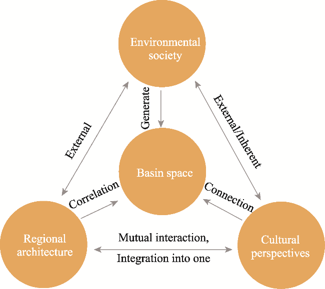
Figure 1 The three dimensions of basin research

3 Research methods

This study adopted the framework of social memory as its methodological foundation for conducting a systematic and multi-layered investigation of typical vernacular settlements in the Zhaozhou Basin, while emphasizing the acquisition of multi-dimensional data and cross-validation to ensure scientific rigor and reliability. Unlike conventional interview and field survey methods, the memory-based approach used in this study focuses on reconstructing the villagers’ collective memories of spatial forms, public rituals, and vernacular dwellings. By transforming qualitative recollections into schematic diagrams and quantifiable indicators, this approach captures not only material features but also the cultural and emotional dimensions embedded in settlement spaces.
Archival research was conducted to trace historical changes in settlement patterns and architectural forms, thereby providing a chronological foundation for understanding long-term spatial evolution. Field observation was essential to verify the physical characteristics of settlement layouts and building structures, to ensure that documented changes correspond to present spatial realities. Oral interviews were indispensable for capturing the residents’ subjective memory narratives, which reveal the cultural meanings and social practices embedded in architectural spaces. Together, these methods complement each other and enable a comprehensive analysis of vernacular settlements through both tangible evidence and intangible recollections.
(1) GIS image analysis provided the technical support at the spatial and environmental level. By employing ASTER GDEM data and combining it with historical maps from the Qing and Republican periods, this study applied terrain and slope analysis tools to precisely model the geographical environment of the settlements. This technique not only reveals the distribution patterns of settlements in terms of elevation, slope, and landform structure but also lays the foundation for interpreting spatial memory and settlement morphology.
(2) Social memory indicator surveys establish a quantitative research pathway. Based on the proposed memory indicator system, this study identified five primary categories: settlement material space, spatial patterns and functions, ancient roads and caravan-related architecture, individual building space and construction, and ritual and spiritual fields, encompassing 15 sub-indicators as the core dimensions. Using the Likert scale, questionnaires were conducted to statistically measure and quantify the villagers’ depth of memory concerning various spatial and cultural elements. This process transforms “memory” from qualitative experience into comparable quantitative data, thereby enhancing the explanatory power and universality of the results.
(3) Oral interviews complement the dynamic dimension of the indicator system. During fieldwork, the research team conducted in-depth interviews focusing on key indicators, and collected narratives from villagers regarding settlement construction, public rituals, ethnic spatial practices, and daily life. These narratives, when cross-referenced with measured memory data, strengthen the logical chain of social memory.
(4) Finally, historical illustrations and documents provide longitudinal comparisons. This study used local chronicles, land deeds, genealogies, and Republican-era maps, combined with oral accounts, to establish a chronological sequence of settlement evolution in the Zhaozhou Basin. Through GIS vectorization and image overlay techniques, a threefold validation (spatial, memory-based, and historical) was constructed, with the aim of restoring the mechanisms of spatial transformation and cultural logic throughout the long-term evolution of settlements.
In conclusion, by integrating GIS-based mapping, social memory indicator surveys, oral interviews, and historical illustration analysis, this study achieved complementarity across the technical, quantitative, and cultural-narrative dimensions. This methodological framework not only deepens our understanding of vernacular settlement spaces in the Zhaozhou Basin but also provides new theoretical and practical perspectives for exploring the interaction between regional architecture and local socio-cultural systems (Figure 2).
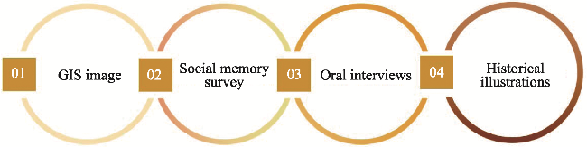
Figure 2 Research methods and process
Ethical considerations were prioritized throughout the research to ensure integrity and confidentiality. Informed consent was obtained from all participants, with clarity on voluntary participation and the use of their responses. Privacy protection measures were implemented, and personal data was anonymized to ensure confidentiality and respect for the participants’ rights.

3.1 Research area: The “Zhaozhou Basin”

The local culture centered on the “Bazi Society of basins” is rooted in the historical legacy of the Nanzhao and Dali Kingdoms. Dali Prefecture contains numerous basins, especially in its eastern region, where settlements developed within a pattern of “large-scale cohabitation and small-scale concentration”. Frequent inter-ethnic interactions and shared regional needs shaped a distinctive spatial structure of basin societies. In the southern Erhai Basin, basins such as Zhaozhou (Fengyi), Menghua (Weishan), Baiya (Midu), Xiangyun, and Binchuan form a connected regional network between mountains and rivers. At the southern tip of Erhai Lake, ancient Zhaozhou served as a key transportation and political hub during the Nanzhao and Dali periods. Its advantageous position (Figure 3) and subtropical plateau monsoon climate, with elevations of 1700-1900 m, make it a representative research area. Based on the 1944 Fengyi County map, Ming-Qing chronicles, and Republican-era maps, the basin primarily covers Fengyi Town in Dali City, Xiaguan to the south, and northern Midu County. Villages often adapted to the terrain and water systems by aligning courtyards along slopes or near streams to achieve ecological balance.
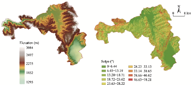
Figure 3 Elevation and slope of the Zhaozhou Basin
Thirty representative villages across different terrain and historical contexts were selected, with Zhihua and Gaocang receiving detailed investigation due to their abundant cultural heritage. These four cases—Zhihua, Beitangtian, Gaocang, and Hanyi—combine historical significance, spatial typology, and reliable data to ensure representativeness for the memory analysis.
GIS methods were applied to integrate the Qing and Republican historical maps with modern elevation data (ASTER GDEM, 30 m, 2024). Digital elevation modeling and slope analysis revealed basin elevations between 1643 m and 1852 m that are concentrated around Fengyi and spread toward northern Midu and Xiaguan (Figure 3). Field studies further traced the architectural spatial narratives within these settlements to establish a methodological pathway for the study of vernacular architecture in the “Bazi Society of basins”.

3.2 Social memory as a method

As an anthropological research method, the “Bazi Society of basins” examines social issues within basin spaces, while focusing on social dynamics and ideologies to transcend geographical and administrative boundaries and explore socio-cultural meanings. When redefined in the context of architecture, the “Bazi Society of basins” can serve as a methodology that starts from geographical and natural conditions to study settlement spaces and architectural forms. This approach extends beyond the architectural entity itself to include the vernacular landscape. By integrating environmental psychology and oral interviews, it delves into the social ideologies behind material forms from a vernacular cultural perspective, gradually deepening through analyses of landscape environments, spatial construction, and conceptual interpretation. Borrowing from anthropology’s concept of the “Bazi Society of basins”, this method can be redefined as an architectural research framework.
In related research, anthropologists have employed “social memory” as a method for reconstructing the historical logic of architectural spatial construction through oral histories. This approach explores the architectural memory underlying material spatial forms, focusing on the social agency involved in the formation of vernacular settlement and architectural spaces while tracing the causal factors behind spatial development.
This methodology necessitates the creation of “communicative memory”, which originates from the informal oral processes of ethnic groups during the historical construction of settlements and architectural spaces within basin societies. The importance of this memory lies not only in its nature but also in why it is remembered, how it connects with other events and spatiotemporal relationships, and whether it conveys specific social memory. The spatial scope of this memory corresponds to the “territoriality” defined by Duara (2005), which refers to a range delineated by pre-existing regional boundaries, such as the sacred domain of a temple defined by the deities worshipped within the community.
This research method requires particular attention to establishing a complete memory logic chain. This involves addressing the diversity, similarity, and differences in memories and ensuring the validity of memory texts. Memory is socially constructed, with individual memory relying on the framework of collective memory. Halbwachs, who first introduced the concept of “collective memory”, argued that social memory examines how individual thoughts are integrated within society and constrained by structural arrangements (Halbwachs, 2002). While his insights are unique, they have limitations. For example, Gao noted in A Review of Research on Social Memory Theory that how people construct and narrate the past largely depends on their current ideas, interests, and expectations. Memories serve the needs of the present, so they are inherently fragmented (Connerton, 2000). Therefore, in practice, it is essential to establish a chronological sequence of memory chains and systematically conduct timely interviews with human groups within the social organizational structure.
In conclusion, this study builds on the concept of social memory to explore how vernacular settlement and architectural spaces are utilized, thereby achieving a degree of “communicative memory”. It investigates the construction of architectural spaces, including the creation of vernacular landscapes (Figure 4), while focusing on significant structures to identify the unique characteristics of settlement and architectural space construction within the “Bazi Society of basins”.
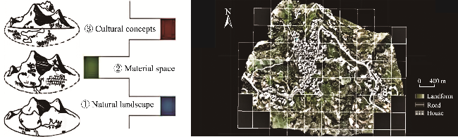
Figure 4 Three-layer cognitive structure of vernacular settlements and GIS-based spatial analysis of the basin
By linking these theoretical perspectives on collective and communicative memory to the Zhaozhou Basin case, this study highlights how social memory provides a lens for uncovering the internal logic of settlement formation, the cultural mechanisms shaping architectural spaces, and the interaction between human ideologies and material environments. This theoretical foundation directly supports the research objective of reconstructing the intrinsic mechanisms behind the evolution of vernacular settlement and architectural forms.

3.3 Construction of a memory indicator system

3.3.1 Selection of representative villages

Over its long history of development and ethnic integration, the Zhaozhou Basin has formed a distinctive spatial structure of vernacular settlement and cultural landscapes within specific natural and cultural contexts. This study explores the humanistic ideologies behind vernacular settlement and architectural spaces from the perspective of the “Bazi Society of basins”.
Historical and local documents were collected and organized to deepen our understanding. These include unpublished internal manuscripts such as Draft History of the Hui People in Zhihua, Dali and Ancient Township Zhihua. Field visits were conducted to key spatial nodes of significant heritage within the settlements. Given the advanced age and limited number of surviving historical witnesses from the existing families in the village, much of the information relied on oral accounts from descendants, as well as preserved materials such as land deeds and family genealogies. Six representative villages were selected for investigation (Table 1).
Table 1 Characteristics of the six sample villages selected for investigation
Serial No. Sample village Historical characteristics Terrain pattern Building type Settlement type
1 Zhihua
Village
Zhaozhou Administrative Center in Yuan Dynasty Local terrace Local customs and dwellings, the main temple, mosque and caravan architecture are abundant in heritage Ancient traffic roads run through or near, and there are many historical remains in the settlements
2 Beitangtian
Village
Residence of Azhali Buddhist and Qingping official in past dynasties Mid-mountain region There are many temples, main temples and ancestral halls
3 Gaocang Village Guards stationed in Ming Dynasty Mainly flat land Local dwellings, main temples, etc. The architectural heritage is seriously damaged
4 Houshan Village Yi nationality cottage Slow slopes at the foothills Local dwellings, main temples, etc. Geographical forms are changeable
5 Zhaozhou Town Zhaozhou town ruins Flat ground Street shops, part of the courtyard Within the boundary of Zhaozhou Town Wall, the old street is left behind
6 Hanyi
Village
Guards stationed in Ming Dynasty Mainly flat land Local dwellings, main temples, etc. The architectural heritage is seriously damaged
Based on the research approach of the “Bazi Society of basins”, this study developed questions for the oral interviews that focused on aspects such as social structure, cultural rituals, spatial morphology, and construction logic. Memory tracing analysis was conducted in conjunction with field investigations. By corroborating the findings from oral interviews with historical documents, this study reconstructed the spatial forms of vernacular settlement and architecture through memory landscapes. This process allowed for the extraction and refinement of memory characteristics associated with the spatial environment of vernacular settlement and architecture in the Zhaozhou Basin.

3.3.2 Quantification of social memory indicators

Based on preliminary field research, various elements and indicators associated with the social memory of the Zhaozhou Basin were identified and refined. Using the maximum variance method in environmental spatial factor analysis, evaluation factors with a load factor value greater than 0.8 were extracted and categorized into five main groups. Each of these five extracted factor components had characteristic values greater than 2, with a cumulative variance contribution rate of 85.66% and communalities greater than 0.8, indicating that the five categories of factors effectively explain most of the variables and demonstrate high reliability. Consequently, the memory-related indicator system was established with spatial and psychological environmental perceptions as the evaluation goals. This system comprises five primary categories of settlement material space and place, settlement forms and spatial patterns, ancient pathways and caravan-related architecture, individual architectural spaces and construction, and ritual fields and spiritual spaces, encompassing a total of 15 sub-indicators (Table 2).
Table 2 Investigation and analysis table of the memory index layer (Unit: %)
Memory index layer B Analytic layer C Have a deep
memory
Moderate memory General memory Can’t
remember
No
impression
Settlement material
space place B1
Characteristics of landscape B1-1 0 31.78 10.78 38.78 18.66
Settlement pattern B1-2 0 41.40 25.68 17.58 15.34
Marker B1-3 21.78 17.67 27.86 28.98 3.71
Settlement form and
spatial pattern B2
Settlement pattern B2-1 1.68 38.59 18.58 29.80 11.35
Spatial pattern B2-2 0 28.78 38.58 15.23 17.41
Spatial distribution B2-3 4.58 18.48 32.29 17.89 26.77
Traces of ancient roads
and caravan buildings
B3
Ancient tea-horse road B3-1 0 16.86 28.89 27.97 29.28
Caravan space B3-2 12.78 30.89 17.87 6.78 31.68
Ancient road scenery B3-3 2.90 14.56 34.79 12.80 34.95
Single building space
and construction B4
Architectural pattern B4-1 6.78 38.89 12.87 10.28 31.18
Spatial function B4-2 3.67 23.77 29.98 21.89 20.6
Visual memory B4-3 0 19.20 20.89 32.00 27.68
Ritual field and spiritual
space B5
Ritual belief B5-1 12.90 17.89 31.81 21.90 29.87
Spiritual space B5-2 23.70 21.89 29.89 2.90 31.87
Field trait B5-3 0 20.99 29.89 8.98 41.98
The survey was conducted during periods when the village populations were most active, such as traditional festivals including the Spring Festival and Mid-Autumn Festival, and it was divided into two phases. The first phase, conducted from December 2022 to January 2023, involved a one- month preliminary investigation to familiarize the researchers with the actual conditions of the study area and provide a foundation for designing the questionnaire. The second phase, from July to September 2023, focused on distributing questionnaires over a three-month period, with surveys conducted on three weekdays, two weekend days, and public holidays each week.
The survey used a Likert scale to evaluate the depth of memory, with five levels of “Deep Memory”, “Moderate Memory”, “General Memory”, “Unclear Memory”, and “No Impression” assigned corresponding values. A total of 200 questionnaires were distributed randomly, with 167 responses collected and 151 deemed valid, yielding a response rate of 90.41%. The collected data are summarized in Table 2.

3.3.3 Data and indicator analysis

According to the statistical results of the questionnaire data, the sample exhibited randomness in its characteristics. Most of the valid responses came from young and middle-aged individuals aged 25 to 40, followed by middle-aged and elderly individuals aged 41 to 70. An analysis of the questionnaire sources revealed that the respondents were primarily local villagers, accounting for 79.89%, with non-local tourists making up a smaller proportion of 20.11%.
The survey found that most respondents had a moderate memory level of their family’s historical and cultural heritage. Due to records in family genealogies and oral transmission by older generations, the spatial memories of vernacular settlement and architecture were relatively profound, with higher memory measurements. The most prominent aspects were the settlement forms and functional markers of architectural spaces, which accounted for 41.4%.
In the dimension of settlement spatial memory, some respondents recalled childhood events related to the construction of the state city and its walls. However, in terms of specific construction events, most respondents reported only a general memory atmosphere, indicating that many heritage sites had been destroyed, which diminished the prominence of these memories. Historical memories of Zhaozhou’s ancient pathways, including the Tea Horse Road, showed moderate recall at 30.89%, with some respondents expressing only vague recollections. Memories of ritual spaces and spiritual domains had a moderate recall rate of 21.89%, which may be related to changes in current religious festival activities.
An analysis of the collected sample data indicated that deeper memory measurements were closely related to spatial locations integral to daily life. These included dimensions such as the usage of settlement and architectural spaces, public temple spaces, home and daily living spaces, and ritual transmission spaces (Figure 5).
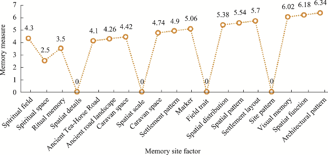
Figure 5 Statistical results of memory measures

4 Research results: Establishing the rule of in-depth memory depiction

Statistical analysis of the memory measurements from respondents indicates that their memories are often closely tied to daily life events (Gao, 2011), with significant emphasis on events that hold practical or personal meaning. The experimental data reveal that people tend to assign specific meanings to observed events, which subsequently influence their memory. The memory indicators show higher measurements associated with settlements, public architectural spaces, and household spaces. The questionnaires collectively demonstrated that the memory schematics of Zhaozhou Basin villagers are relatively rich and influenced by various factors, including their values, intentions, emotions, moods, and past experiences. These findings form the foundation for establishing the rule of in-depth memory depiction.

4.1 Villager schema 1: In-depth depiction of settlement geographical memory

Memories of the spatial layout of certain settlements in Zhaozhou have attracted the attention of local villagers, particularly regarding the methods of spatial division within the Zhaozhou Basin (such as the “Four Gates Boundaries”, “Beyond the Four Gates”, and the “Thirteen Settlements of Midu”). Villagers also recalled how traditional road networks and settlement boundaries often took natural conditions into account, like aligning routes with terrain contours and watercourses. Such practices reflected an ecological adaptation that linked spatial organization not only to social divisions but also to environmental constraints and opportunities. In oral interviews, many villagers were able to draw memory maps of their settlement spaces. For example, Mr. Ma, a villager from Zhihua Village in the Zhaozhou Basin, analyzed the settlement layout under the influence of geographical, cultural, and social norms. Drawing on historical records and field investigations, he recalled overlapping historical spatial forms of settlements, enclosed farming fields, and the Wei-Suo system, thus identifying the driving factors behind the formation of settlement spatial morphology.
As discussed above, the memory characteristics of villagers correspond closely with the historical attributes and geographical patterns of different settlements. For instance, Zhihua Village, as the administrative center of Zhaozhou during the Yuan Dynasty (Sample 1), is particularly strong in the residents’ memories of settlement boundaries and land cultivation systems, reflecting its historically significant “territoriality”. By contrast, Beitangtian Village (Sample 2), located in a mid-mountain region and historically associated with Qingping officials, is remembered by villagers more for its temples, ancestral halls, and other religious spaces. Similarly, in Gaocang and Hanyi Villages (Samples 3 and 6), where garrisons were stationed during the Ming Dynasty, the oral interviews revealed that villagers recalled the “Wei-Suo field system” and “defensive buildings” with greater frequency. These quantitative survey data and the memory diagrams drawn by villagers mutually reinforce each other, indicating a strong correspondence between settlement morphology, historical characteristics, and social memory.
This comparison demonstrates that the quantitative survey results in Table 2 not only supplement the details of oral memories but also reveal differentiated spatial memory patterns across settlement types in the minds of villagers. Such patterns provide empirical support for further exploration of the relationship between the “territoriality” defined by basin societies and the spatial forms of vernacular settlements.

4.2 Villager schema 2: In-depth depiction of public temple memory

The construction memories related to public temples, which are integral to the spiritual and religious lives of the community, have garnered attention from some villagers. With the strong influences of new rural development initiatives, rapid urbanization, and industrial development, the traditional vernacular settlement culture and architectural wisdom of the Zhaozhou Basin are at risk of disappearing. The preservation of the remaining vernacular architectural heritage has become an urgent task. The new socio-cultural context has reconstructed the use patterns of certain public ritual spaces, thus creating a more orderly organization of public settlement spaces.
Field observations revealed that population growth and increased density have intensified the frequency of secular daily activities. To accommodate the demand for public activities, some public temples (e.g., the Benzhu Temple in Gaocang Village and the Benzhu Temple in Zhaozhou City) have been gradually repurposed or transformed into public facilities. However, certain public temples still retain spatial memories in the collective consciousness.
For instance, at the Bianzhi Temple near Fengyi Town, the temple’s caretaker has preserved many relics of the ancient temple and used his illustrative language to create a spatial schematic of Bianzhi Temple’s environment, which showcases a hierarchical and progressive spatial relationship (Figure 6). Similarly, in the Hanyi Village on the southern side of the basin, villagers guided the research team to view the location of the temple’s water source as remembered in their collective memory, which provided a spatial recollection of the temple’s environment.
Figure 6 Bianzhi Temple and the temple space layout diagram drawn by the temple master
These cases illustrate the functional transformation of temples in village social life. Once serving mainly as ritual and spiritual centers, some temples are now repurposed as community activity spaces or heritage sites. This shift shows how temples can adapt to modern needs while still acting as anchors of collective memory.

4.3 Villager schema 3: In-depth depiction of vernacular dwelling memory

The Zhaozhou Basin is rich in caravan architectural heritage. However, with the rapid pace of urbanization, this valuable architectural cultural legacy is at risk of disappearing. The survey for this study included many descendants of caravan workers, including elderly individuals knowledgeable about caravan activities. In-depth investigations were conducted into the architectural relics associated with well-known caravan leaders and horse drivers, including Ma, who was also invited to create memory schematics.
In the homes of several caravan descendants, many precious historical materials were uncovered, such as land deeds from the Qing Dynasty, old photographs of houses before demolition, and partial floor plans. Through oral memory interviews, the construction process of some caravan courtyards was explored, and memory schematics were used to reconstruct models of certain architectural spaces.
For instance, oral accounts from descendants of large courtyard households revealed that the floor plan and spatial arrangement followed the traditional Dali layout of a three-hall courtyard with a screen wall (San Fang Yi Zhao Bi, literally “three rooms with one facing screen wall”, a typical residential layout in Dali). In this spatial arrangement, the main residence where the caravan leader typically lived was in the north-facing main house. The main house consisted of three rooms: a central living room flanked by two bedrooms. Notably, one wing of the courtyard housed an extended structure used as a stable for horses. The second floor mainly served as a granary for storing crops and food. Gun holes were carved into the second-floor walls for anti-theft purposes, allowing the occupants to observe external activity and enhancing the building’s defensive capabilities (Figure 7).
Figure 7 Spatial analysis of a caravan residence—from land deed to layout plan
In summary, these three case studies reveal that important spatial nodes have undergone notable changes, such as settlement boundaries, public temples, and courtyard layouts. Despite these shifts, the villagers’ narratives consistently highlighted the social rituals, religious spaces, and agricultural practices as central elements of their collective memory. At the same time, while certain vernacular architectural forms have been preserved, such as ancestral halls and caravan courtyards, others including stables and defensive features, are gradually disappearing, which reflects both continuity and loss within the cultural landscape. By connecting these findings to Halbwachs’ theory of collective memory, cultural geography’s notion of symbolic landscapes, and historical anthropology’s view of architecture as social practice, this study establishes a solid theoretical grounding for interpreting memory categories.

5 Discussion

5.1 Social memory as an expression of community environmental spatial characteristics

Social memory is an expression of community environmental spatial characteristics that reflects the resonance and continuity of individuals and groups within specific geographical, cultural, and historical contexts. It is not only a representation of material spatial forms but also a comprehensive manifestation of human consciousness, value systems, and emotional attachment. In the vernacular settlement and architectural spaces of the Zhaozhou Basin, social memory is preserved and reconstructed through the geographical layout of settlements, public temple belief sites, and the construction forms of vernacular dwellings. For comparison, the preservation of the village of Hallstatt in Austria illustrates how collective memory is embedded in settlement patterns and lakefront layouts. Like Zhaozhou, Hallstatt relies on the integration of geographical features and cultural traditions to sustain its identity. However, whereas Hallstatt’s preservation is largely policy- and tourism-driven, the Zhaozhou Basin highlights bottom-up practices rooted in the villagers’ lived memories, showing both a shared reliance on collective memory and distinct local approaches.
This memory reflects the community’s perception of and attachment to the environment, which shapes the cultural symbolic meaning of the environmental space. It becomes a bridge connecting history and reality, the material and the spiritual, and deeply revealing the dynamic interplay between regional culture and human activities. Rural communities are shaped by social memory, which also serves as the research pathway for the “Bazi Society of basins” team in the field of historical anthropology. The memories of Zhaozhou Basin villagers were triggered during the survey questionnaire conducted in this study.
This investigation integrates individuals’ memories and perceptions of local material and spiritual spaces, and links these memories to their surrounding social environments, thus evoking attention to the past and present of rural society. Through the research pathway of the “Bazi Society of basins”, this study calls for the regeneration of social memory, which holds special value for maintaining rural social order and promoting rural revitalization. In practice, the “memory deep description” method can also inform rural renewal and heritage conservation projects by providing cultural context for planning proposals, thus ensuring that new interventions align with collective memory and local identity.
In current rural spatial planning practices, there are already cases of “memory reuse”. For example, in some traditional villages in Northwest Yunnan, such as the Shuhe Ancient Town in Lijiang and the Dukezong restoration project in Shangri-La, public spaces including old opera stages, ancestral halls, and watchtower ruins have been transformed through restoration and functional regeneration into village museums, community activity centers, or intangible cultural heritage experience sites. These projects not only preserve and extend the villagers’ collective memory but also revitalize historical spaces, enabling them to serve contemporary public life once again.
By employing historical texts and combining them with the research methods established through the rules of in-depth memory depiction, this study continually documents the endangered settlement culture, analyzes the spatial archetypes of vernacular architecture, and explores the fundamental historical memory evolutionary process of traditional settlement spaces. From settlements and architecture to key spatial nodes within villages, this study restores historical architectural imagery, with the aim of leaving a written record of historical materials for future generations of Zhaozhou to reflect upon and remember.

5.2 Social memory as a pathway for environmental spatial regeneration

As a pathway for environmental spatial regeneration, social memory revitalizes traditional environmental spaces by evoking the collective recognition and emotional attachment of communities to historical places and cultural practices. In the vernacular settlement and architectural spaces of the Zhaozhou Basin, social memory not only preserves cultural heritage such as temples and traditional dwellings but also provides an essential foundation for the reconstruction and continuity of environmental spaces through oral histories, ritual traditions, and local documents.
This memory-driven spatial regeneration is not merely the restoration of material forms but also the revival of cultural spirit, and serves as a significant driving force for the inheritance and innovation of regional culture. It offers profound insights into the sustainable development of urban and rural spaces. During this investigation, village residents actively adjusted and innovated their social memories, thus making adaptive choices. This not only helps to unify rural social groups and shape social order but also revitalizes social memory, thereby achieving the reflective preservation and transmission of rural social memory.
Under the conditions of the modern era, fully leveraging the carriers of social memory allows for more effective protection and preservation of traditional minority cultures, strengthening the cohesion and awareness of village communities. This, in turn, enables better utilization of rural social memory to shape social order and maintain rural social structures, thereby promoting the healthy functioning of rural society.
As a pathway for environmental spatial regeneration, social memory requires attention not only to the integrity of cultural heritage transmission but also to inclusivity and adaptability in the process of modernization. This will ensure a dynamic balance between memory and space, and genuinely provide sustainable cultural significance and living value to communities.

5.3 Memory reconstruction as an exploration of interdisciplinary research methods

The reconstruction of social memory and its methodological significance can be specifically addressed by highlighting how it informs the study of vernacular settlement and architectural spaces. Although research on vernacular settlement and architecture increasingly exhibits a diversified character, existing studies often struggle to fully reveal the underlying causes behind the formation of material spaces. Building on the foundational research of the “Bazi Society of basins” team, this study positions the “Bazi Society of basins” as an architectural research method and explores the integrity, diversity, and relationship between vernacular settlements, architectural spaces, and corresponding regional ideologies of habitation from the perspective of “social memory” to uncover their formative reasons.
By collecting foundational data, conducting field investigations, and recording interviews, more systematic research outcomes can be achieved. Starting from the spatial analysis and spatial elements emphasized in architectural studies, this approach is expanded to incorporate methods from historical anthropology and sociology, such as surveys on concepts of habitation and investigations into the formation of ideologies. This integrated research framework enables a deeper exploration of issues related to the material spatial forms that are connected to concepts of habitation, potentially offering an expansion of research perspectives.
Clarifying the holistic social characteristics of the “Bazi Society of basins” and reconstructing the overall spatial form of society through “memory reconstruction” are particularly beneficial for understanding the cultural causes of vernacular settlement and architecture in the “Bazi Society of basins”. Although future research may not be able to provide a fully comprehensive synthesis for such broad issues, it should aim to advance our understanding by presenting the development of research on vernacular settlement and architecture in the “Bazi Society of basins”. This represents a step forward in expanding the study and recognition of vernacular architecture.

6 Conclusions

This study took the concept of “Bazi Society” proposed by anthropologists as its theoretical foundation and adopted “social memory” as the methodological framework to conduct a systematic investigation of vernacular settlements and architectural spaces in the Zhaozhou Basin. The main contributions can be summarized in three aspects.
(1) Construction of the “Thick Description of Memory” method. By combining questionnaire surveys, oral interviews, and historical illustrations, we proposed the “Thick Description of Memory” approach and visualized the villagers’ spatial cognition through memory diagrams, which provides a new methodological tool for the study of vernacular settlements and architecture.
(2) Proposal of the social memory pathway of basin spaces. Through case studies of Zhihua Village, Beitangtian Village, Gao Cang Village, and Hanyi Village, this study revealed the correspondence between social memory and historical functions as well as geographical patterns. Based on this, we put forward the “social memory pathway of basin spaces”, which illustrates how local communities shape settlements and architectural spaces through collective memory.
(3) Verification of the applicability of interdisciplinary methods. This study integrated GIS analysis, the social memory indicator system, oral history, and historical document analysis, to achieve cross-validation across architecture, anthropology, and history. This demonstrates the effectiveness of interdisciplinary approaches in the study of Bazi Society.
In conclusion, through methodological innovation, pathway construction, and interdisciplinary practice, this study not only deepens our understanding of vernacular settlements in the Zhaozhou Basin but also provides a new theoretical framework and practical value for the study of regional architecture and cultural heritage.
Furthermore, the establishment of a theoretical paradigm suitable for studying the vernacular settlement and architecture of the “Bazi Society of basins” may enable the “Basin” to continue as a vibrant and enduring research subject by portraying it as a beautiful homeland shared by regional ethnic groups.
The introduction of technical methods, such as GIS schematic analysis and the application of memory quantification metrics, aids in capturing spatial features and memory expression. However, these methods risk simplifying the complex emotions and social relationships embedded in memory through precise measurements. This risk highlights the need to emphasize the excavation of intangible cultural elements and respect the participatory rights of community members when relying on social memory for environmental and spatial regeneration, to avoid tendencies toward over-instrumentalization and oversimplification into mere symbols. Theoretically, this study links social memory with spatial research, which offers a new lens on the relationship between collective memory and vernacular forms. Methodologically, it establishes a replicable “memory deep description” framework that integrates qualitative and quantitative analysis. Future research may integrate GIS with oral histories for spatial-temporal reconstruction and apply the “memory deep description” method in cross-regional comparative studies.
At the same time, this study contributes to ecological architectural conservation by demonstrating how vernacular settlements in the Zhaozhou Basin have adapted to terrain, water resources, and local climate. This ecological perspective, combined with social memory analysis, underscores the importance of integrating environmental adaptability with cultural continuity in future conservation practices.
Future research should be based on historical materials such as official archives, local chronicles, and inscriptions, while also integrating the method of social memory to explore in depth the relationship between the local reconstruction of Bazi society and vernacular architecture within specific historical timeframes. The focus is not merely to supplement spatial studies with historical facts, but rather to reveal how local communities, through specific historical events, constructed the material spaces of the basin and experienced processes of reorganization and division. On this basis, a coordinate axis can be established between material spatial phenomena and the spatiotemporal sequences of human society, allowing for a multi-perspective and comprehensive examination of architectural historical facts.
Accordingly, this paper proposes three additional research directions.
(1) Strengthening the cross-analysis of historical documents by fully utilizing the mutual corroboration of official archives, local chronicles, inscriptions, and oral records to construct a multi-dimensional system of historical investigation.
(2) Incorporating participatory approaches by introducing methods such as villager participation and community co-construction, so that the research not only remains at the academic level but also serves local cultural identity and practice.
(3) Constructing a spatial-memory identification and intervention model by combining GIS technology with social memory data to establish a coupling model between spatial features and memory elements, thereby providing operational tools for rural planning, heritage protection, and spatial regeneration.
In summary, this study expands the research pathway of vernacular settlements and architecture by integrating social memory with interdisciplinary methods. Looking ahead, with the inclusion of richer historical materials and participatory approaches, research on the “Bazi Society” will achieve greater systematic depth and practical relevance. Nevertheless, this study has certain limitations, including a limited sample size, relatively narrow geographic coverage, and gaps in available historical records. These constraints may influence the generalizability of the findings. Acknowledging these boundaries provides a more objective understanding of the study’s scope and highlights the directions for further research.
[1]
Ackerman R E. 1976. Ancient cultures of Siberia and Pacific Basin. Current Anthropology, (2): 771-773.

[2]
Andersen D W, Picard M D. 1973. Tectonics and depositional history of Rocky Mountain intermontane basin. AAPG Bulletin, 57(4): 18-21.

[3]
Anna-Maria V. 2009. Evaluation of a sustainable Greek vernacular settlement and its landscape: Architectural typology and building physics. Building and Environment, 44: 289-290.

[4]
Connerton P. 2000. How societies remember. Translated by BiR. Shanghai, China: Shanghai People’s Publishing House. (in Chinese)

[5]
Cun Y J, Ma J X. 2020. Methods and issues in researching Bazi Society in the Yunnan-Guizhou Plateau. Journal of Guangxi University for Nationalities (Philosophy and Social Science Edition), 42(6): 2-5. (in Chinese)

[6]
Cun Y J, Ma J X. 2022. Bazi society: A perspective of historical anthropology. Open Times, (4): 19-26. (in Chinese)

[7]
Ding C B, Xiao D W. 2022. Content and method of studying minority traditional villages and dwellings based on cultural geography. South Architecture, (2): 72-76. (in Chinese)

[8]
Duara P. 2005. Culture, power, and the state. Nanjing, China: Jiangsu People’s Publishing House.

[9]
Duff A I. 2007. Culture and ecology of Chaco Canyon and the San Juan Basin. Journal of Anthropological Research, 63: 121-122.

DOI

[10]
Fan X, Ma X. 2020. Field survey of Guxin Village, Shexian County, Handan. Ancient Architecture and Garden Technology, (1): 81-83, 87. (in Chinese)

[11]
Frampton K. 2007. Studies in tectonic culture:The poetics of construction in nineteenth and twentieth century architecture. Translated by WangJ Y. Shanghai, Beijing, China: China Architecture and Building Press. (in Chinese)

[12]
Gao P. 2011. A review of research on social memory theory. Journal of Northwest University for Nationalities (Philosophy and Social Science Edition), (3): 112-120. (in Chinese)

[13]
Halbwachs M. 2002. On collective memory. Translated by Bi R. Shanghai, China: Shanghai People’s Publishing House. (in Chinese)

[14
Huffman T N, Earley F L. 2017. Apishapa rock art and Great Basin Shamanism: Power, souls, and pilgrims. The Journal of Archaeology, Consciousness and Culture, (10): 119-144.

[15]
Jacobs J. 2006. A geography of big things. Cultural Geographies, 13: 1-27.

DOI

[16]
Liu H. 2019. Research on the spatial patterns of vernacular settlement in the Jinqu Basin. Diss., Beijing, China: Beijing Forestry University. (in Chinese)

[17]
Ma J. 2017. Zhao Zhou and Tiesuo Qing in the Ming Dynasty: Geographical environment and ethnic construction centered on the “Bazi” in Western Yunnan. Dali National Culture Research Series, (1): 229-262. (in Chinese)

[18]
Na W, Li J, Li S, et al. 1979. Pathways for the rational use of farmland in the mountainous areas of Changshun County, Guizhou Province. Natural Resources, (2): 54-63. (in Chinese)

[19]
Pakiser L C, Press F, Kane M F. 1960. Geophysical investigation of Mono Basin, California. Geological Society of America Bulletin, (1): 415-447.

[20]
Potter P E. 1977. Paleocurrents and basin analysis. Berlin, Germany: Springer-Verlag.

[21]
Rapoport A. 2020. House form and culture. Translated by Zhang M. Taipei, China: Jingyu Xiang Publishing House. (in Chinese)

[22]
Stewart J H. 1942. Native cultures of the Intermontane (Great Basin) Area. American Antiquity, (7): 335-336.

[23]
Wang D. 2019. Residential civilization and home life:Architectural anthropology research in southwest ethnic regions. Beijing, China: China Architecture and Building Press. (in Chinese)

[24]
Willard B. 1946. Origin of the Lackawanna Basin. Pennsylvania Journal of Geology, (2): 246-251.

[25]
Wu J P. 1992. On the cultural influence and settlement types in the formation of ethnic settlement. Geographic Research, 11(3): 50-57. (in Chinese)

[26]
Xu W, Wei N. 2017. Fractals of valley settlements:Theoretical models and practical guidance. Beijing, China: China Architecture and Building Press. (in Chinese)

[27]
Yang M. 2021. Investigation and analysis of Hakka Dwellings and cultural geographic factors in the Fujian-Guangdong-Jiangxi Border Area. Ancient Architecture and Garden Technology, (6): 55-58, 64. (in Chinese)

[28]
Yang Z, Li J, Jia M, et al. 2023. Research on the water adaptation spatial patterns of traditional settlements in Xiong’an New Area. Ancient Architecture and Garden Technology, (4): 70-75. (in Chinese)

[29]
Zhao M, Liao D. 2015. “Bazi Society” in the Yunnan-Guizhou Plateau:A historical anthropology perspective on the southwest frontier. Kunming, China: Yunnan University Press. (in Chinese)

[30]
Zhao W. 2022. Research on the spatial patterns and dynamic mechanisms of traditional villages in the Fen River Valley. Diss., Xi’an, China: Xi’an University of Architecture and Technology. (in Chinese)

[31]
Zheng Y, Zhang Y, Li Y. 2023. Analysis of the spatial layout and natural topography of the military defense system of Zhenbao Town along the Ming Great Wall. Ancient Architecture and Garden Technology, (5): 118-122. (in Chinese)

Outlines

/