Ecosystems and Ecosystem Services

Metropolitan Expansion Pattern and Its Landscape Ecological Pattern Response: A Case Study of Hangzhou, China

  • CHEN Youjun , 1 ,
  • ZHANG Xiaoyao 2 ,
  • HU Xinyue 2 ,
  • YU Hu , 2, *
Expand
  • 1. Tourism College of Zhejiang, Hangzhou 311231, China
  • 2. Institute of Geographic Sciences and Natural Resources Research, Chinese Academy of Sciences, Beijing 100101, China
*YU Hu, E-mail:

CHEN Youjun, E-mail:

Received date: 2024-04-01

  Accepted date: 2024-11-01

  Online published: 2025-08-05

Supported by

The National Natural Science Foundation of China(42471274)

Abstract

Rapid urbanization significantly influences urban renewal and the construction of new spaces in metropolises within developing countries, particularly affecting the ecological patterns and security of urban landscapes. This study conducts an in-depth analysis of landscape ecological change indicators in Hangzhou from 1990 to 2020, summarizing typical driving models and formation mechanisms behind these changes while proposing optimization strategies. The findings indicate that since 1990, driven by urban expansion, Hangzhou’s landscape ecological pattern has experienced overall stability alongside localized drastic transformations, revealing three distinctly different stages around West Lake, along the Beijing-Hangzhou Grand Canal, and across the Qiantang River. This evolution is primarily propelled by public service facilities, tourism development, industrial parks, landscape ecological corridors, and other forms of spatial expansion. Such processes reflect a comprehensive interplay among population urbanization dynamics, land use policies for urban areas, adjustments in administrative divisions, as well as the snowball effect stemming from capital-driven growth and wealth accumulation associated with new urban space development. The results presented herein serve as a representative case for understanding both the characteristics and driving forces behind changes in China’s urban landscape ecological patterns; they also hold significant implications for predicting and optimizing regulatory frameworks concerning spatial expansion policies in other nations and regions.

Cite this article

CHEN Youjun , ZHANG Xiaoyao , HU Xinyue , YU Hu . Metropolitan Expansion Pattern and Its Landscape Ecological Pattern Response: A Case Study of Hangzhou, China[J]. Journal of Resources and Ecology, 2025 , 16(4) : 1014 -1026 . DOI: 10.5814/j.issn.1674-764x.2025.04.008

1 Introduction

In the past century, global urbanization has profoundly influenced human society. As a worldwide phenomenon, urban expansion represents one of the most significant anthropogenic impacts on the terrestrial environment (Horn and Van Eeden, 2018; Amponsah et al., 2022; Zhuang et al., 2023). By 2030, the land area occupied by cities globally may increase threefold (Alberti, 2005). The expansion of urban construction land is characterized by spatial scale enlargement, morphological adjustments, density renewal, and temporal succession (Wachsmuth et al., 2016). However, there remains a paucity of detailed studies examining urban landscape ecology across various industrial clusters, which constrains our understanding of the interplay between the development of functional urban clusters and landscape ecology at medium and micro scales. To sustain vibrant economic and social growth in urban areas, it is essential to harmonize the relationship between urban expansion and landscape ecology to ensure that urban ecosystems evolve towards livable ecological environments.
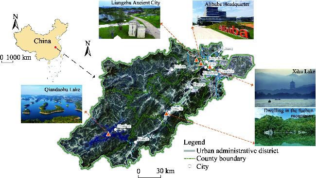
During the process of urban expansion, the ongoing growth and concentration of populations and industries significantly alter the landscape ecological pattern (Salvati et al, 2018), profoundly impacting urban life, habitation, and production activities (Grimm et al., 2008). The transformation of agricultural land into developed urban areas results in impervious surfaces such as roads, standalone commercial complexes, and densely populated residential zones, thereby transforming the original natural ecological landscape pattern (Tanner and Fuhlendorf, 2018; Wang et al., 2019). This alteration in landscape configuration leads to spatial characteristics marked by high overall fragmentation and localized patchiness, which disrupts the integrity of urban ecosystems, affects biodiversity distribution, and influences travel behaviors among urban residents. Concurrently, the outward spread associated with urban expansion heightens both the frequency and intensity of natural disturbances while introducing new disruptions or prolonged pressures that inflict unprecedented damage on the landscape ecological patterns (Feng et al., 2020), consequently altering nutrient cycling and energy flow within natural systems (Berling-Wolff and Wu, 2004; Lu et al., 2023). Conversely, changes in landscape patterns can reflect significant transformations in the structure, processes, and functions of urban ecosystems. Such shifts may render heat waves, waterlogging events, and air pollution as potential threats to urban ecology (Gasper et al., 2011; Gibb et al., 2020), leading to increased ecological vulnerability while diminishing resilience within cities (Strohschon et al., 2013; Pickett et al., 
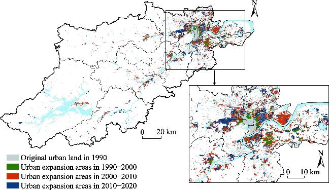
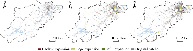
2014). Nevertheless, research on the interplay between urban spatial expansion and changes in landscape ecological patterns has largely overlooked the differentiated impacts and responses induced by the new-type spatial development model. Most pertinent studies have quantified urban expansion within a spatiotemporal framework to ascertain the correlation between urban expansion and alterations in landscape ecological patterns (Jaeger and Schwick, 2014; Li et al., 2015). The scope of these investigations ranges from individual cities to multiple cities and urban agglomerations. For instance, Darrel and Potere (2010) conducted a comparative analysis of landscape pattern changes across 120 cities globally, while Ran et al. (2023) examined landscape patterns and ecosystem health in 212 major Chinese cities. Nearly all findings indicate that metropolitan expansion and urban expansion lead to fragmentation, complexity, and heterogeneity in landscape patterns (Bosch et al.,
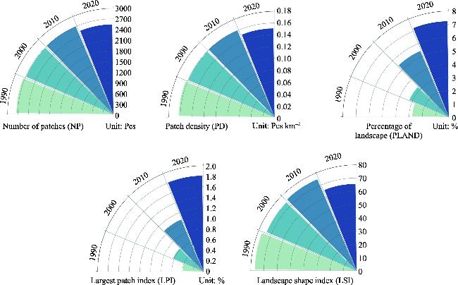
 2020; Wu et al., 2011). Methodologically, the impact of urbanization on landscape patterns is typically assessed quantitatively through indices of landscape patterning as well as Morphological Spatial Pattern Analysis (MSPA), with most indicators being integrated into spatiotemporal gradient analyses (Salvati, 2014; Zhang and Wang, 2023). Additionally, some studies incorporate nighttime lighting data to monitor shifts in urban landscapes and simulate economic activities within these areas (Li et al., 2019). However, there remains a scarcity of comprehensive investigations into the evolution of landscape ecological patterns under varying models of urban expansion; thus, it is imperative to analyze their underlying driving mechanisms.
China’s urbanization is notable for its rapid pace and extensive scale. The accelerated trajectory of metropolitan expansion in China commenced post-1990, particularly following the real estate reforms implemented in 1998. This growth of urban metropolitan areas has been accompanied by the development of commercial districts, residential neighborhoods, tourist attractions, subway systems, and major transportation hubs, resulting in a multifaceted new urban landscape (Cai et al., 2020). After 2010, with the ongoing enhancement of development models for satellite cities surrounding metropolises, the outward sprawl of these urban centers has significantly altered landscape ecological patterns (Yu, 2021), often impacting regional environments, climate change dynamics, mobility issues, and their interrelation with sustainability through processes such as urban expansion and land degradation or landscape transformation. In contrast to Western nations, the urban expansion arising from China’s metropolitan growth exhibits greater diversity in spatial manifestations and formation mechanisms (Oueslati et al., 2015; Rubiera et al., 2016). In major metropolitan regions like Beijing, Shanghai, and Hangzhou, much attention is directed towards analyzing overall spatial characteristics—including suburbanization trends, dual-center and sub-center structures within development zones (Wang et al., 2020; Gao et al., 2023). However, there remains a lack of awareness regarding the landscape ecological challenges posed by this urban expansion. This paper investigates the fundamental characteristics and patterns governing changes in landscape ecology during metropolitan growth phases to inform more targeted policy formulation aimed at optimizing regulatory frameworks.
Therefore, based on the basic geographic information data, land use data and urban landscape change data from 1990 to 2020, this paper applies the urban spatial expansion and landscape indices to systematically investigate the urban expansion pattern and its landscape ecological pattern driving type. The objectives of the study include: 1) To deeply analyze the characteristics of temporal dynamics and spatial changes of landscape ecological patterns based on the case of Hangzhou Metropolitan Area; 2) To identify the expansion modes of the metropolitan area, and the main types of driving forces in its landscape ecological patterns; and 3) to propose a regulatory strategy for the sustainable development of landscape ecology in the metropolitan area.

2 Materials and methods

2.1 Study area

Hangzhou is a prominent metropolis within China’s Yangtze River Delta city cluster (Figure 1), recognized as one of the six largest urban agglomerations globally. The forest coverage rate in Hangzhou is 67%. As of 2023, Hangzhou boasts a permanent population of approximately 12.204 million, with a population density of 735 persons km-2 and a GDP reaching 1.81 trillion yuan, alongside an urbanization rate of 83.29%. In the same year, Hangzhou ranks 35th on the list of the world’s wealthiest cities and is home to 22 unicorn companies, placing it seventh worldwide in terms of unicorn count. The landscape ecological patterns in Hangzhou is influenced by topographical features, demographic factors, industrial development, and enhancements in ground transportation infrastructure. Over the past four decades, rapid socio-economic advancement has been paralleled by significant urban expansion; specifically, the built-up area surged from 69 km2 in the 1990s to an impressive 801.63 km2 by 2020—an increase that includes an additional transformation of 135 km2 between 2019 and 2020 alone. This extensive conversion has resulted in substantial ecological land being repurposed for urban construction purposes, profoundly impacting the ecological configuration of its urban landscape.
Figure 1 Overview and location of Hangzhou Metropolitan Area

2.2 Methods

In order to describe in detail the impact of urban landscape ecological patterns, this paper introduces the urban spatial expansion index and landscape pattern analysis (Chen et al., 2013), analyzes the interplay between urban expansion and changes in landscape ecological patterns (Zhou et al., 2014), and employs the Landscape Expansion Index (LEI) to reflect the typical driving pattern of urban construction land expansion.

2.2.1 The Urban Spatial Expansion Index

The rate and intensity of urban expansion are critical indicators for assessing the characteristics of urban spatial growth (Hu et al., 2021). Specifically, the rate of urban expansion (Mur) quantifies the temporal and spatial dynamics associated with changes in urban land area, effectively reflecting the magnitude of alterations within a defined timeframe (Zhang et al., 2022). Conversely, the intensity of urban expansion (Iur) measures the vigor of land area growth during a specific period and serves as a key indicator for characterizing the spatial heterogeneity inherent in urban expansion intensity (Zhai et al., 2020).
The formulas are as follows:
Mur=ΔUijΔtij×ULAij×100
Iur=ΔUijΔtij×TLAij×100
where ∆Uij is the urban land expansion area of the i-th study unit in period j; ∆tij is the time span of period j ; ULAij is the urban land area of the i-th study unit in period j; and TLAij is the total land area of the i-th study unit.

2.2.2 Landscape Pattern Index

Urban land use expansion can exert significant and irreversible impacts on landscape patterns (Ouyang and Zhu, 2020). The continuous increase in urban land area will, to some extent, induce corresponding changes in landscape characteristics (e.g., number, size, shape). Consequently, analyzing the landscape pattern attributes associated with urban expansion can enhance our understanding of the spatial dynamics during specific periods within the urban growth process. So, we selected five widely recognized landscape pattern indices (Table 1) that possess clear definitions: Number of patches (NP), percentage of landscape (PLAND), largest patch index (LPI), landscape shape index (LSI), and patch density (PD). Fragstats 4.2 software was employed to characterize the alterations in landscape patterns throughout the period of urban land expansion from 1990 to 2020.
Table 1 Landscape Pattern Index and its indicative function
Landscape Pattern Index Unit Symbol Ecological significance Relationship with urban land expansion
Number of patches Pcs NP Number of patches of a selected landscape type Higher the value, higher the dispersion of the urban land landscape
Patch density Pcs km-2 PD Number of patches per km2 land area Higher the value, higher the fragmentation of the urban land landscape
Percentage of landscape % PLAND The percentage of a certain landscape area in the total landscape area, used to determine the dominant landscape elements in the landscape Higher the value, higher the expansion intensity of the urban land landscape
Largest patch index % LPI The percentage of the largest patches in the whole landscape Higher the value, higher the landscape-dominance of the urban land landscape
Landscape shape index - LSI Reflect the variability or complexity of patch shapes in the landscape Higher the value, more complicated the shape of urban land landscape

2.2.3 Landscape Expansion Index

The Landscape Expansion Index (LEI) effectively characterizes the dynamic evolution of urban landscape expansion and delineates the spatial patterns associated with this growth. This approach partially addresses the limitations of existing methods in capturing dynamic information during the landscape expansion process. In this study, we employ both the Landscape Expansion Index (LEI) and Area Weighted Landscape Expansion Index (AWLEI), as proposed by Wu et al. (2012), to quantitatively assess the scale and patterns of urban land and landscape expansion in Hangzhou.
The formulas are as follows:
LEI=APAoAP+Ao
$A W L E I=\frac{\sum_{i=1}^{n} L E I_{i}}{n}$
where LEI represents the Landscape Expansion Index of new urban land patches; AP denotes the area of these urban land expansion patches; and Ao refers to the area of original patches adjacent to the urban land expansion patches. The value of LEI ranges from [0,100], with an enclave expansion mode occurring when LEI = 0; a fringe expansion mode when LEI is in (0, 50); and an edge expansion mode when LEI falls within [50, 100). Additionally, infill expansion occurs when LEI is in [50, 100) (Zhang et al., 2021). AWLEI stands for Area Weighted Landscape Expansion Index; LEIi indicates the Landscape Expansion Index for i-th patch; n represents the total number of expansion patches within this category.

2.3 Data collection

The data utilized in this study primarily comprise land use data and fundamental geographic information. Specifically, the land use data were sourced from the Resource and Environment Science Data Center of the Chinese Academy of Sciences (http://www.resdc.cn), featuring a spatial resolution of 30 m × 30 m. This paper selected land use data for four specific years at ten-year intervals: 1990, 2000, 2010, and 2020. To extract urban land, this research binarized the land use data across different periods and categorized all non-urban land types accordingly. The basic geographic information was obtained from the National Center for Basic Geographic Information (http://www.resdc.cn) and includes administrative boundary data as well as river and lake system information for Hangzhou.

3 Results

3.1 Spatio-temporal characteristics of urban expansion

From the perspective of temporal change, the spatial expansion of Hangzhou city from its center to periphery between 1990 and 2020 can be categorized into three distinct stages. During this period, the area designated for urban construction in Hangzhou increased consistently, rising from 463.05 km² in 1990 to 1217.95 km² in 2020, resulting in a net increase of 754.91 km² and an overall expansion rate of approximately 16.30% (Table 2). Throughout the study duration, the urban construction land underwent a transformation characterized by “slow development followed by rapid growth”, which includes phases of slow growth, rapid expansion, and subsequent optimization and adjustment.
Table 2 The area, rate and intensity of urban land expansion in Hangzhou
Period Growth
area (km²)
Growth rate (%) Growth Intensity
Index (%)
1990-2000 89.95 1.94 0.0534
2000-2010 380.02 6.95 0.2254
2010-2020 337.74 3.69 0.2003
Initially, during the slow-growth phase from 1990 to 2000, urban land expansion was marked by gradual development with an increase of only 89.95 km²—an expansion rate of merely 1.94% and an intensity factor of just 0.0534%. This era coincided with the early stages of China’s reform and opening-up policy when urban construction began emerging from previous developmental constraints. Consequently, the growth rate for urban land area remained relatively subdued.
The rapid expansion phase occurred from 2000 to 2010, during which Hangzhou experienced the most significant urban land expansion in terms of both area and rate, achieving a total of 380.02 km²—the highest in the past three decades. This surge was primarily driven by the establishment of development zones and reforms in the urban housing system, two pivotal factors contributing to China’s urbanization, alongside the swift development of the city’s economy and related industries.
The subsequent optimization and adjustment stage spanned from 2010 to 2020; although Hangzhou’s urban land expansion continued at a high rate and intensity, it decelerated compared to the previous decade, covering an area of 337.74 km² with an expansion rate and intensity of 3.69% and 0.2003%, respectively. Acknowledging the adverse effects associated with rapid growth during earlier years, Hangzhou initiated measures to gradually regulate urban expansion intensity, aiming for a model characterized by coupled socio-economic-spatial development (He et al., 2019).
From the perspective of spatial changes, urban land expansion is characterized by the outward growth from the original urban core to peripheral areas (Figure 2). This spatial expansion manifested as a continuous outward progression, predominantly concentrated in northern Hangzhou— specifically in Shangcheng District, Gongshu District, Xihu District, Binjiang District, Xiaoshan District, and Qiantang District—which exhibited a relatively rapid increase from 1990 to 2010. Furthermore, emerging urban districts such as Qiantang and Binjiang served as primary drivers for this accelerated expansion during the period. Guided by the fifth iteration of Hangzhou’s urban master plan, construction activities in Fuyang District, Tonglu County, Jiande City, and Chun’an County along the Qiantang River basin were restricted; consequently, these areas experienced a comparatively slow rate of development. From 2010 to 2020, construction land within Gongshu District, Shangcheng District, and Xiaoshan District continued its encroachment into Yuhang District—a fringe area of the city—indicating an onset of suburbanization trends within Hangzhou.
Figure 2 Spatial distribution of urban land expansion in Hangzhou, 1990-2020

3.2 Landscape ecological responses to urban expansion

The landscape ecological changes in Hangzhou serve as a spatial visual representation of the land use transformations induced by urban expansion. An analysis of patch numbers reveals that the NP index of landscape ecology exhibited a fluctuating downward trend from 1990 to 2020, decreasing from 2748 in 1990 to 2547 in 2020 (Figure 3). This indicates that with the rapid advancement of urbanization in Hangzhou, the vacant areas between the original older urban districts (such as Shangcheng District, Xiacheng District, and Xihu District) are progressively being filled, resulting in a pronounced dense and continuous distribution of urban landscapes alongside an increase in compactness.
Figure 3 Landscape index performance in Hangzhou, 1990-2020
Concurrently, new urban clusters expanding on the periphery (including Xiaoshan District and Binjiang District) adopt a clustered development model within their urban planning and construction frameworks, thereby also reflecting a relatively compact ecological pattern for their urban landscapes. Further examination of patch density reveals that the PD index trends align with those observed for the NP index; both demonstrate a fluctuating downward trajectory with an overall reduction of 7.31% (Figure 3), suggesting that the structural complexity of Hangzhou’s urban landscape ecological pattern is diminishing while simultaneously indicating some alleviation in landscape fragmentation.
During the study period, the rapid expansion of urban construction land in Hangzhou and continuous agglomeration led to an increase in the area of dominant patches, thereby significantly enhancing their degree of dominance across various landscape types. The PLAND index and LPI index for urban landscapes in Hangzhou exhibited a consistent and stable upward trend (Figure 3). Specifically, the PLAND index rose from 2.76% in 1990 to 7.24% in 2020, while the LPI index increased from 0.39% to 1.81%. Over this three-decade span, both indices demonstrated considerable changes. The LSI indices for urban land landscapes in Hangzhou during four analyzed periods from 1990 to 2020 were recorded as follows: 76.93, 73.97, 75.24 and 65.71 respectively; with a significant decrease compared with earlier years (Figure 3). Despite a slight increase over time, the overall trend of the LSI index indicates a decline within Hangzhou City’s urban landscape metrics. This suggests that with effective implementation of urban planning and land use policies, the expansion pattern of urban construction land in Hangzhou is becoming increasingly regularized and simplified.
In general, as urbanization progresses, the urban landscape of Hangzhou has evolved from an initial state characterized by irregularity and structural fragmentation to one marked by clustering and regularity. This transformation suggests that urban expansion in Hangzhou exemplifies a “diffusion-convergence” process, which aligns with the hypothesis of “diffusion-convergence” proposed by Dietzel et al. (2005) to a certain extent.

3.3 The pattern and type effect of urban expansion

3.3.1 Expansion patterns

From 1990 to 2020, the spatial expansion of urban land use in Hangzhou can be categorized into three primary modes: marginal, infill, and enclave (Table 3, Figure 4). Among these, the edge expansion mode consistently predominates, averaging 89.59%. However, notable variations exist in the spatial expansion patterns of urban land use across different periods. Between 1990 and 2000 and from 2000 to 2010, Hangzhou’s urban land space exhibited characteristics of enclave expansion, marginal expansion, and infill expansion respectively. Specifically, during the period from 1990 to 2000, enclave expansion constituted 5.24%, marginal expansion accounted for a significant 94.75%, while infill expansion was minimal at just 0.01%. In contrast, from 2000 to 2010, enclave expansion rose to 16.13%, with marginal expansion decreasing slightly to account for 83.79% and infill remaining low at only 0.08%. This indicates that leapfrog development is a crucial form of outward urban growth characterized by constructing new developments away from existing built-up areas within designated zones or clusters. Notably during the period between 2010 and 2020, the proportion of infilled expansions reached zero, suggesting that the capacity for further spatial extension has been exhausted due to saturation within established urban areas.
Table 3 Proportion of LEI value in different level, 1990-2020 (Unit: %)
LEI level 1990-2000 2000-2010 2010-2020
LEI=0 5.24 16.13 9.76
0<LEI<50 94.75 83.79 90.24
50≤LEI<100 0.01 0.08 0
Figure 4 Spatial distribution of urban expansion patterns in Hangzhou, 1990-2020
Consequently, it is evident from the preceding analysis that the spatial expansion of urban land use in Hangzhou during the study period was predominantly characterized by marginal expansion, with enclave expansion serving as a supplementary mode. The pattern of spatial expansion for urban land use in Hangzhou progressively extends outward along the peripheries of existing urban areas. Concurrently, certain patches of considerable size are detached from their original clusters to facilitate spatial growth, gradually evolving into new industrial or residential enclaves—such as development zones or newly established urban districts—which have emerged as significant focal points for future urban construction.
Based on the spatial differentiation characteristics of the three expansion modes, urban land in Hangzhou underwent significant spatial expansion from 1990 to 2000, primarily centered around existing urban land patches within the city center (Figure 5). Additionally, some marginal expansion areas emerged in Xiaoshan District on a limited scale, closely associated with the construction of Hangzhou Xiaoshan Airport, which signified new industrial space development. This period marked a departure from the previous single-center marginal expansion model that relied heavily on the integration of Shangcheng District, Xiacheng District, and West Lake District. From 2000 to 2010, as edge expansion further progressed within the central urban area, notable agglomerations of edge expansion patches developed in Xiaoshan District, Qiantang District, and along the coastal areas of Qiantang River; these spaces were predominantly allocated for business districts, residential zones, and tourism developments. Furthermore, there was a significant increase in enclave expansion patches during this timeframe concentrated mainly in Linping District and Xiaoshan District. Between 2010 and 2020, multi-center marginal expansions across central cities—including Xiaoshan District, Qiantang District, Linping District—and coastal regions along Qiantang River are expected to expand dramatically; concurrently, the synergistic effects driven by this multi-core approach will gradually mature.
Figure 5 Spatial distribution of typical urban expansion patterns in Hangzhou, 1990-2020

3.3.2 Driver types

The alteration of the landscape ecological pattern across various stages of urban expansion in Hangzhou is driven by the emergence of new urban spaces, the revitalization of existing city areas, and the development of residential zones to facilitate population urbanization (Li et al., 2018; Zhang and Han, 2024). In light of these dynamics, this study categorizes the driving forces behind urban spatial expansion in Hangzhou into four distinct categories: growth propelled by public service facilities, initiatives for recreational urbanization, development within central commercial districts, and enhancement of ecological landscape corridors (Figure 5).
(1) Public service facility-driven urban expansion
The urban expansion driven by public service facilities exhibits a “point with surface” characteristic, representing an effective approach to promote both marginal and infill expansion. Typically, the construction of large-scale transportation infrastructure—such as urban expressways, intercity railways, and subways—facilitates the diffusion and re-agglomeration of human flow and logistics, thereby stimulating the development of significant nodes along these routes or other ancillary facilities in the vicinity, including residential communities, industrial parks, and commercial districts. A quintessential example is the expansion of Qianjiang New City in Hangzhou. Between 1990 and 2000, Qianjiang New City experienced small-scale marginal expansion primarily centered around existing urban land parcels. From 2000 to 2010, with projects such as the city balcony of Qianjiang New City, riverside landscape belt, civic center, Hangzhou Grand Theater, and International Conference Center coming to fruition, new edge expansion patches proliferated further within Qianjiang New City alongside emerging enclave expansions. During this period, however, overall fragmentation was pronounced with limited agglomeration among these patches. The period From 2010 to 2020 saw the initiation of developments like Qianjiang New City 2.0 and Exhibition New City as well as Hangzhou Asian Games Village; consequently expanding towards the eastern part of the city gradually. At this stage, there was a slight deceleration in urban land expansion rates while newly added patches continued predominantly through marginal means; nevertheless connectivity among these urban land patches improved significantly leading to a marked reduction in overall landscape fragmentation.
(2) Central business city-driven urban expansion
It is a kind of urban expansion mode driven by the aggregation of business scale, which has certain cultivation nature, and the expansion scale is relatively small, and is dominated by marginal expansion and enclave expansion. The urban expansion of Linping District in Hangzhou is a typical type. 1990-2000, Linping District had only a weak marginal expansion, and the expansion patches were mainly concentrated in the central and southeastern regions. As the 21st century progressed, the arrival of Wal-Mart and Yintai Liqun stores drove the development of transportation and real estate in Linping District. During this period, the urban land coverage of Linping District expanded significantly, with new enclave expansion patches scattered in the eastern part of the district, initially forming Linping New City. From 2010 to 2020, more businesses and developers would be attracted to gather in Linping New City due to the advantages of convenient transportation and commercial development. At this time, the number of exclave-type expansion patches and edge-type expansion patches increased simultaneously.
(3) Urban recreation-driven urban expansion
In the post-industrialization era, the development of the urban tourism industry has emerged as a significant driver of urban expansion in Hangzhou. Fueled by advancements in tourism, the construction of public facilities has been further enhanced to accommodate the needs of seasonal tourists and local employers. The urban expansion pattern observed in Chun’an County, Hangzhou exemplifies a typical tourism-driven model. During the early stages of reform and opening up, Chun’an County explicitly defined its urban strategy focused on tourism development; however, at this time, its urban expansion activities were relatively inconspicuous. Since the onset of the 21st century, with the rise of mass tourism and recognition as a 5A scenic area at Qiandao Lake, Chun’an County has experienced substantial urban expansion characterized by significant increases in new land patches—predominantly marginal and enclave expansions. Nevertheless, during this period, Chun’an’s urban land growth remained nascent with spatial distribution appearing discrete and fragmented. From 2010 to 2020, due to the establishment of ecological functional zones and regulatory policies from Hangzhou regarding urban land expansion scale, Chun’an’s rate of land expansion gradually decelerated; only limited fringe expansions occurred around existing urban patches. At this stage, the spatial structure of land use within Chun’an County matured progressively while exhibiting more concentrated spatial distribution patterns alongside increasingly regularized landscape forms.
(4) Natural corridor integrated urban expansion
The construction of landscape ecological corridors aims to mitigate unchecked urban expansion. And, it is gradually evolving into urban green spaces that enhance leisure tourism while preserving its fundamental role in environmental protection. To counteract the tendency for expansive “big cake” urban land development driven by mere economic interests, natural corridors have been effectively employed to regulate such sprawling growth in Hangzhou’s urban development. The city’s expansion influenced by landscape ecological corridors has primarily undergone a developmental trajectory characterized as “crossing the river- walking along the river”. From 1990 to 2000, Hangzhou implemented a cross-river development strategy that alleviated spatial constraints on urban land expansion. This enhancement of cross-river connectivity facilitated gradual growth in the eastern region of Qiantang River; however, this expansion remained largely confined to Xiaoshan District across from the central city. Between 2000 and 2010, urban land expanded westward along Qiantang River with patches predominantly emerging at its periphery. In the subsequent decade, further growth occurred on both banks of Qiantang River with increasing density, culminating in a coordinated development pattern featuring multiple functional blocks parallel to the river.

3.3.3 Formation mechanism

From the perspective of influencing mechanisms, the urban expansion of Hangzhou is propelled by a complex interplay of urban topography, historical context, transportation networks, infrastructure development, and advancements in science and technology. Firstly, the western region of Hangzhou is characterized by hilly and mountainous terrain, while the eastern part features a plain with an intricate river network. The Qiantang River traverses the city from west to east before flowing directly into the sea. Historically, Hangzhou served as a central hub for Jiangnan along the Beijing-Hangzhou Grand Canal—an essential north-south artery in China—leveraging its natural harbor at Qiantang River to develop concentrically around West Lake and its port facilities. Following its designation as Zhejiang Province’s capital, Hangzhou significantly enhanced its capacity to attract population and industry, initiating an expansion trend oriented along the canal’s axis from point-based growth towards a more linear north-south orientation. Post-1990s developments aimed at creating new industrial spaces led to a strategic dispersal towards western suburbs where real estate investments could be secured at lower costs. Such intensive suburban expansions have notably altered Hangzhou’s ecological landscape pattern; transitioning from linear development alongside the Beijing-Hangzhou Grand Canal to cross-river growth on both banks of Qiantang River has transformed what was once a singularly centered urban layout into one that embraces multiple centers.
Moreover, large-scale infrastructure projects such as Xiaoshan Airport have further catalyzed this urban expansion process through enhanced external connectivity. Consequently, Hangzhou’s urban structure has become increasingly intricate; shifting from single-core growth centered around West Lake to multi-centered development patterns. After 2000, efforts aimed at broadening Hangzhou’s urban scale and elevating its status among China’s first-tier cities resulted in incorporating Xiaoshan and Yuhang into central areas via administrative adjustments. This interventionist approach facilitates access for managers seeking extensive land resources and industrial opportunities within surrounding regions while simultaneously promoting construction initiatives like Qianjiang New City through substantial infrastructural investment coupled with intelligent technological applications.
In summary, it is evident that Hangzhou has undergone three distinct phases of urban expansion: initially around West Lake; subsequently along the Canal; followed by cross-river developments across Qiantang River. Throughout these phases—driven by public service facility enhancements, central business district proliferation, recreational space creation, and ecological corridor establishment—the city’s periphery continues expanding while addressing renewal needs through leapfrog strategies influenced by land use conditions alongside administrative authority dynamics.

4 Discussion and conclusions

The influence of urban expansion on the transformation of landscape ecological patterns in the West is both cyclical and gradual (Chen, 2009). Worldwide, there are two predominant modes of urban spatial expansion: the extension model, exemplified by countries such as the United States, Canada, and Australia, which incrementally enhances urban spatial capacity around central areas; and the content model represented by Japan, South Korea, and Singapore that prioritizes vertical construction through taller buildings while optimizing underground space utilization (Liang, 2024). China’s strategy for urban spatial expansion has assimilated certain characteristics from Western nations but is significantly shaped by its administrative framework within a context defined by a large population relative to limited land resources and complex topography. Firstly, Hangzhou's limited land availability necessitates that construction indices prioritize new industrial spaces while public service facilities are adapted from existing city infrastructure during initial development phases. This requires optimization and adjustment of functional spaces within the urban fabric alongside strategic placement of significant projects and facilities. Secondly, for industries demanding substantial land use—such as key developments like Alibaba’s headquarters or G20 Convention Center—marginal expansions occur at the city’s periphery. Thirdly, the intricate interplay between topography, river networks, and transportation does not imply that all available spaces can be utilized for construction purposes. Given constraints posed by sites such as Liangzhu Ancient City World Heritage Site and Qiantang River Financial Harbor, establishing basic service facilities with seamless connectivity to central urban areas presents challenges; thus leapfrog enclave space expansion strategies are employed.
These three approaches collectively shape ongoing transformations in Hangzhou’s landscape pattern. Initially centered around West Lake during earlier phases of study development—the urban landscape pattern along Beijing-Hangzhou Grand Canal evolves through collaborative constructions parallel to this network encompassing blocks and industrial zones. Ultimately driven by leapfrog expansions along Beijing-Hangzhou Grand Canal results in an emergent urban landscape pattern characterized by a transition from point-based developments to comprehensive surface spread across Qiantang River while maintaining connections with Hangzhou’s original old city across the waterway. In this paper, we examine the phase transitions of landscape ecological patterns through the lens of urban land use structures to analyze the expansion patterns and driving forces behind urban landscape changes during the urbanization process. This significant endeavor to integrate urban ecological transformations with humanistic processes elucidates the interconnections among ecological, economic, and social elements within urban environments, thereby enhancing our understanding of the causal relationships underlying ecological changes in urban landscapes.
Firstly, this paper employs the Landscape Ecological Pattern Index (LEPI) to characterize and analyze the effects of urban expansion on the landscape ecological patterns of Hangzhou, China, from 1990 to 2020. It elucidates the typical driving models and formation mechanisms underlying these changes. Our findings are as follows: Between 1990 and 2020, Hangzhou’s area expanded from 463.05 km² to 1217.95 km², exhibiting a developmental trajectory characterized by “slow development-fast development-slow development.” The spatial transformation from center to periphery reveals a pattern marked by rapid fragmentation and renewal, filling and expansion, as well as plate expansion; spatially represented by swift fragmented renewal transitioning from central areas outward toward filling and plate expansion. This temporal-spatial evolution reflects a shift from industrialization towards an urban service-oriented economy underpinned by urban industrial transformation policies and supportive measures aimed at enhancing green spaces and living environments. The adjustment in urban developmental direction—encompassing comprehensive urban planning, revitalization of older districts, establishment of new industrial zones, and construction of residential areas—serves as a primary factor influencing alterations in the aforementioned landscape ecological patterns. Since 1990, changes in Hangzhou’s urban landscape have predominantly manifested through the conversion of natural or semi-natural landscapes such as arable land, green spaces, water bodies, and unused lands into residential areas for both urban-rural populations along with industrial sites and public service facilities (He et al., 2019). During the decade spanning from 2000 to 2010—stimulated by ongoing industrialization policies—the extent of urban land in Hangzhou peaked within nearly three decades with an increase of approximately 380.02 km² over ten years; this underscores the phased impact exerted by urban development policies. In the 1960s, Hangzhou was designated as a “comprehensive industrial city,” vigorously promoting industries such as iron production, cotton textiles manufacturing, and steamboat operations. Post-2000 saw Hangzhou adopt strategies emphasizing “industry revitalizing cities,” during which time secondary industry proportions stabilized around fifty percent; following this period after 2009 led to prioritizing service industries strategically. Throughout this decade marked by rapid large-scale expansions driven largely through extensive developments like numerous industrial parks alongside real estate booms fueled by substantial influxes of workers seeking residence or employment opportunities resulted in significant transformations within surrounding landscapes’ ecological frameworks. Post-2010 witnessed shifts influenced primarily due to financial crises wherein Hangzhou redefined its identity towards becoming a modern service-oriented tourism hub while systematically phasing out traditional industrial enterprises via outward relocations coupled with efforts focused on transforming aging infrastructures alongside developing adjacent tourist regions—a transition that also corresponded with declines in construction scale efficiency.
Secondly, the alterations in landscape ecological patterns induced by urban expansion in Hangzhou exhibited a transition from irregularity and fragmentation to clustering and functionalization, thereby validating the “diffusion-integration” hypothesis within the context of urban expansion (Dietzel et al., 2005). The spatial growth of Hangzhou was predominantly concentrated in its core urban area, constrained by natural landscapes such as West Lake and the Qiantang River water system. With evolving urban planning concepts, Hangzhou initiated the development of distinctive industrial parks in peripheral areas including Xiaoshan District, Yuhang District, Qiandao Lake, among other functional zones. Adjustments to land use structures were made during urban planning efforts to enhance both landscape and ecological functions within satellite cities, ultimately creating a cohesive functional landscape that aligns with Hangzhou’s main city. Evidently, this evolutionary process reflects a series of impacts stemming from shifts in policy regulation—from initial absence to refined governance—and from lackluster development planning towards systematic layered implementation. Urban expansion in Hangzhou encompassed three modes: edge expansion, infill expansion, and enclave expansion. Throughout these processes of growth, changes in landscape ecological patterns manifested diversely across four driving types: public service facility-driven; urban recreation development-driven; central business district-driven; and ecological landscape corridor-driven. These categories illustrate how policymakers facilitated industrial economic growth through constructing public service facilities and industrial parks while attracting substantial numbers of workers into residential areas— thereby stimulating real estate markets. In earlier phases, rapid urbanization resulted in fragmented landscapes characterized by intermingling rural-urban interfaces alongside emerging urban villages and industrial enclaves. Subsequently—following industry relocations—there has been an increase in green spaces and recreational lands which have contributed positively toward patch integrity while promoting more organized construction practices within the cityscape. In later stages marked by transitions from an industrial-centric model towards modernity, Hangzhou began vacating traditional industries while vigorously advancing sectors like modern services tourism along with rural economies—all complemented by developing ecological landscape corridors that spurred rapid economic progress for the city. This transformation journey also involved diverse strategies encompassing old city revitalization initiatives renovation projects targeting aging industrial zones as well as suburban expansions.
Ultimately, the transformations in Hangzhou’s urban landscape ecological patterns epitomize China’s urbanization trajectory, reflecting fundamental characteristics of land use structures and responses to landscape ecological changes during metropolitan expansion. This phenomenon bears resemblance to the late industrialization pathways observed in numerous developed nations. In terms of driving forces, these changes represent an inevitable outcome of transitioning from government-led urbanization to a model driven by a synergy between governmental and market forces. To achieve staged industrial development objectives, the government facilitated alterations in land use structures through initiatives such as constructing industrial parks, revitalizing older districts, and renewing aging industrial zones— thereby instigating shifts in landscape ecological patterns. Regarding driving forms within urban landscape ecological transformations prompted by urbanization, three distinct processes have been experienced sequentially. This progression reflects an evolution in the comprehensive power of urban expansion from weak to strong, small-scale to large-scale endeavors, and from singular influences to multifaceted dynamics. Throughout this process, capital investment and social engagement gradually converged with governmental oversight to foster overall transitions in urban land use and landscape ecological patterns—from fragmentation towards infill development and functional patching. Moreover, China’s urban policy framework alongside its methods for developing industrial parks as well as concepts surrounding green development have played pivotal roles; specifically indicating that changes within China's urban landscapes and ecological frameworks illustrate how various forces—including government entities, capital investments, societal contributions—have achieved equilibrium and compromise while pursuing their respective goals throughout the ongoing process of urbanization.
Considering the availability of statistical data, this paper only considers part of the administrative area of Hangzhou City, and does not take into account the impact of administrative division adjustment from 1990 to 2000. In the follow-up study, technical methods, such as gridding assignment, are adopted to deepen the study on the changes and effects of administrative division adjustment on urban landscape pattern, in order to understand more comprehensively the policy factors in the process of ecological sustainability of urban landscape in China.
[1]
Alberti M. 2005. The effects of urban patterns on ecosystem function. International Regional Science Review, 28(2): 168-192.

[2]
Amponsah O, Blija D K, Ayambire R A, et al. 2022. Global urban sprawl containment strategies and their implications for rapidly urbanising cities in Ghana. Land Use Policy, 114: 105979. DOI: 10.1016/j.landusepol.2022.105979.

[3]
Berling-Wolff S, Wu J G. 2004. Modeling urban landscape dynamics: A case study in Phoenix, USA. Urban Ecosystems, 7(3): 215-240.

[4]
Bosch M, Jaligot R, Chenal J. 2020. Spatiotemporal patterns of urbanization in three Swiss urban agglomerations: Insights from landscape metrics, growth modes and fractal analysis. Landscape Ecology, 35(4): 879-891.

[5]
Cai Z Y, Liu Q, Cao S X. 2020. Real estate supports rapid development of China’s urbanization. Land Use Policy, 95: 104582. DOI: 10.1016/j.landusepol.2020.104582.

[6]
Chen J H. 2009. Urban sprawling and polarization: Critique of the spatial development trend of the internationalization city. Academic Monthly, 41(4): 11-18. (in Chinese)

[7]
Chen L D, Sun R H, Liu H L. 2013. Eco-environmental effects of urban landscape pattern changes: Progresses, problems, and perspectives. Acta Ecologica Sinica, 33(4): 1042-1050. (in Chinese)

[8]
Darrel J G, Potere D. 2010. Global analysis and simulation of land-use change associated with urbanization. Landscape Ecology, 25(5): 657-670.

[9]
Dietzel C, Herold M, Hemphill J J, et al. 2005. Spatio-temporal dynamics in California’s Central Valley: Empirical links to urban theory. International Journal of Geographical Information Science, 19(2): 175-195.

[10]
Feng X H, Xiu C L, Bai L M, et al. 2020. Comprehensive evaluation of urban resilience based on the perspective of landscape pattern: A case study of Shenyang City. Cities, 104: 102722. DOI: 10.1016/j.cities.2020.102722.

[11]
Gao C, Feng Y J, Wang R, et al. 2023. 50-year urban expansion patterns in Shanghai: Analysis using impervious surface data and simulation models. Land, 12(11): 2065. DOI: 10.3390/land12112065.

[12]
Gasper R, Blohm A, Ruth M. 2011. Social and economic impacts of climate change on the urban environment. Current Opinion in Environmental Sustainability, 3(3): 150-157.

[13]
Gibb R, Redding D W, Chin K Q, et al. 2020. Zoonotic host diversity increases in human-dominated ecosystems. Nature, 584(7821): 398-402.

[14]
Grimm N B, Faeth S H, Golubiewski N E, et al. 2008. Global change and the ecology of cities. Science, 319(5864): 756-760.

DOI PMID

[15]
He H M, Zhang J X, Cui G H. 2019. “Constant” and “change” in urban strategic planning: Review and thinking on Hangzhou strategic planning. Urban Planning Forum, (1): 60-67. (in Chinese)

[16]
Horn A, Van Eeden A. 2018. Measuring sprawl in the Western Cape Province, South Africa: An urban sprawl index for comparative purposes. Regional Science Policy & Practice, 10(1): 15-24.

[17]
Hu P, Li F, Hu D, et al. 2021. Spatial and temporal characteristics of urban expansion in Pearl River Delta urban agglomeration from 1980 to 2015. Acta Ecologica Sinica, 41(17): 7063-7072. (in Chinese)

[18]
Jaeger J A G, Schwick C. 2014. Improving the measurement of urban sprawl: Weighted Urban Proliferation (WUP) and its application to Switzerland. Ecological Indicators, 38: 294-308.

[19]
Li F Z, Zheng W, Wang Y, et al. 2019. Urban green space fragmentation and urbanization: A spatiotemporal perspective. Forests, 10(4): 333. DOI: 10.3390/f10040333.

[20]
Li G D, Sun S, Fang C L. 2018. The varying driving forces of urban expansion in China: Insights from a spatial-temporal analysis. Landscape and Urban Planning, 174: 63-77.

[21]
Li Q Y, Fang C L, Li G D, et al. 2015. Quantitative measurement of urban expansion and its driving factors in Qingdao: An empirical analysis based on county unit data. Journal of Resources and Ecology, 6(3): 172-179.

DOI

[22]
Liang C. 2024. The multi-scale spatial pattern optimization of urban fringe based on ecological adaptivity: A case study of Xiamen. Diss., Tianjin, China: Tianjin University.

[23]
Lu W L, Zhang D, Ren Q, et al. 2023. Impacts of future urban expansion on natural habitats will intensify in China: Scenario analysis with the improved LUSD-urban model. Landscape Ecology, 38(10): 2547-2567.

[24]
Oueslati W, Alvanides S, Garrod G. 2015. Determinants of urban sprawl in European cities. Urban Studies, 52(9): 1594-1614.

PMID

[25]
Ouyang X, Zhu X. 2020. Spatio-temporal characteristics of urban land expansion in Chinese urban agglomerations. Acta Geographica Sinica, 75(3): 571-588. (in Chinese)

DOI

[26]
Pickett S T A, McGrath B, Cadenasso M L, et al. 2014. Ecological resilience and resilient cities. Building Research & Information, 42(2): 143-157.

[27]
Ran P L, Frazier A E, Xia C, et al. 2023. How does urban landscape pattern affect ecosystem health? Insights from a spatiotemporal analysis of 212 major cities in China. Sustainable Cities and Society, 99: 104963. DOI: 10.1016/j.scs.2023.104963.

[28]
Rubiera Morollón F, González Marroquin V M, Pérez Rivero J L. 2016. Urban expansion in Spain: Differences among cities and causes. European Planning Studies, 24: 207-226.

[29]
Salvati L. 2014. Agro-forest landscape and the ‘fringe’ city: A multivariate assessment of land-use changes in a sprawling region and implications for planning. Science of the Total Environment, 490: 715-723.

[30]
Salvati L, Zambon I, Chelli F M, et al. 2018. Do spatial patterns of urbanization and land consumption reflect different socioeconomic contexts in Europe? Science of the Total Environment, 625: 722-730.

[31]
Strohschon R, Wiethoff K, Baier K, et al. 2013. Land use and water quality in Guangzhou, China: A survey of ecological and social vulnerability in four urban units of the rapidly developing megacity. International Journal of Environmental Research, 7: 343-358.

[32]
Tanner E P, Fuhlendorf S D. 2018. Impact of an agri-environmental scheme on landscape patterns. Ecological Indicators, 85: 956-965.

[33]
Wachsmuth D, Cohen D A, Angelo H. 2016. Expand the frontiers of urban sustainability. Nature, 536(7617): 391-393.

[34]
Wang C Y, Sun X F, Wang M, et al. 2019. Chinese cropland quality and its temporal and spatial changes due to urbanization in 2000-2015. Journal of Resources and Ecology, 10(2): 174-183.

DOI

[35]
Wang X X, Shi R T, Zhou Y. 2020. Dynamics of urban sprawl and sustainable development in China. Socio-Economic Planning Sciences, 70(1): 100736. DOI: 10.1016/j.seps.2019.100736.

[36]
Wu J G, Jenerette G D, Buyantuyev A, et al. 2011. Quantifying spatiotemporal patterns of urbanization: The case of the two fastest growing metropolitan regions in the United States. Ecological Complexity, 8(1): 1-8.

[37]
Wu P, Zhou D, Gong H. 2012. A new landscape expansion index: Definition and quantification. Acta Ecologica Sinica, 32(13): 4270-4277. (in Chinese)

[38]
Yu B B. 2021. Ecological effects of new-type urbanization in China. Renewable and Sustainable Energy Reviews, 135(2): 110239. DOI: 10.1016/j.rser.2020.110239.

[39]
Zhai Y G, Qu Z Y, Lv M. 2020. Analysis of urban expansion in northwest minority area: A case study of Hohhot City. Science of Surveying and Mapping, 45(4): 97-104. (in Chinese)

[40]
Zhang M, Zheng L J, He Y H. 2022. Characteristics and influencing factors of urban expansion in the Yangtze River Economic Belt in recent 30 years. Science of Surveying and Mapping, 47(8): 186-196. (in Chinese)

[41]
Zhang X, Han H. 2024. Characteristics and factors influencing the expansion of urban construction land in China. Science Report, 14(1): 16040. DOI: 10.1038/s41598-024-67015-8.

[42]
Zhang X M, Du H M, Wang Y, et al. 2021. Watershed landscape ecological risk assessment and landscape pattern optimization: Take Fujiang River Basin as an example. Human and Ecological Risk Assessment: An International Journal, 27: 2254-2276.

[43]
Zhang X S, Wang Y D. 2023. Spatial and temporal heterogeneity analysis of urban expansion and ecological landscape in rapid urbanization area in Central China: A case study of Wuhan City. Resources and Environment in the Yangtze River Basin, 32(8): 1583-1593. (in Chinese)

[44]
Zhou X, Chen L, Xiang W N. 2014. Quantitative analysis of the built-up area expansion in Su-Xi-Chang Region, China. Chinese Journal of Applied Ecology, 25(5): 1422-1430. (in Chinese)

PMID

[45]
Zhuang Q W, Shao Z F, Li D R, et al. 2023. Impact of global urban expansion on the terrestrial vegetation carbon sequestration capacity. Science of the Total Environment, 879: 163074. DOI: 10.1016/j.scitotenv.2023.163074.

Outlines

/