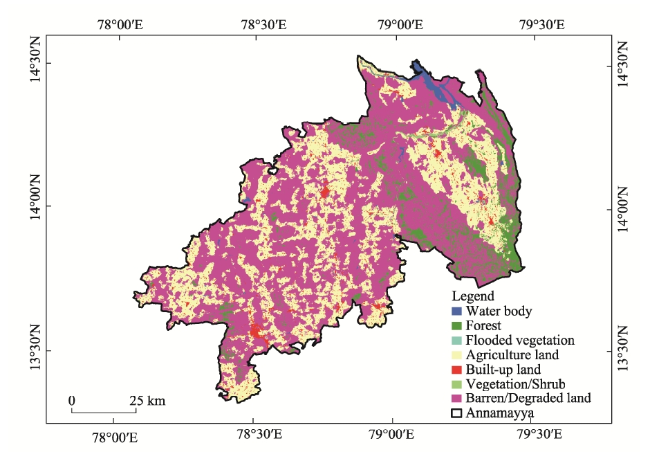
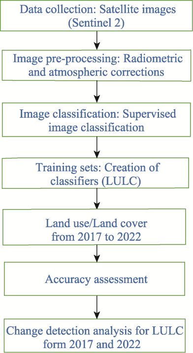
The study of land use and land cover (LULC) changes has received considerable scholarly interest because of its substantial effects on ecosystems, climatic patterns, and socio-economic structures. The use of remote sensing and GIS has become essential in the field of monitoring and comprehending these transitions. These techniques enable researchers to examine the temporal and geographical patterns of changes occurring in various landscapes (Areendran et al.,
2013; Butt et al.,
2015; Rizk and Rashed,
2015). This literature review examines the significant contributions made by prior research in the domains of temporal remote sensing, GIS analysis, and LULC transitions, therefore providing a foundation for the publication titled “Temporal Remote Sensing and GIS Analysis of LULC Transitions” (Pattanaik et al.,
2011; Ayele et al.,
2018; Langat et al.,
2021). The study of remote sensing data across time has seen significant development, progressing from single-date studies to more sophisticated multi-temporal techniques that effectively capture and represent dynamic changes. The importance of time-series data in the identification and characterization of LULC changes is emphasized in the research conducted by Li et al. (
2016) and Dutta et al. (
2018). The usefulness of long-term datasets in capturing progressive and abrupt transformations is shown by the usage of Landsat and Sentinel satellite images, as evidenced in the studies conducted by Roy and Inamdar (
2019) and Verburg et al. (
2008). A variety of change detection techniques have been devised for the analysis of LULC transitions, including both pixel-based and object-based methodologies. The first research conducted by Lu et al. (
2004) demonstrated the effectiveness of post-classification comparison. Subsequent studies by Defries and Rosenzweig (
2010) have further advanced the field by using more sophisticated methodologies, including spectral mixture analysis and decision trees. The use of machine learning methods, as shown by Clewley et al. (
2014), has enhanced the precision and effectiveness in identifying changes in land cover. The utilization of GIS in comprehending LULC transitions surpasses mere change detection, as it encompasses the spatial study of the factors influencing these changes and their subsequent impacts (Pande et al.,
2021; Hussain et al.,
2022). The importance of spatial measurements in identifying urban development patterns has been highlighted in urban expansion research, as evidenced by the work of Angel et al. (
2012). Furthermore, the examination of landscape fragmentation, as expounded upon by McGarigal and Marks (
1995), has provided insights into the ecological consequences of LULC changes. The utilization of GIS methodologies has facilitated the examination of the spatial framework surrounding LULC transformations, as well as the identification of the fundamental factors driving these alterations. In their study, Wang et al. (
2016) used spatial measures to evaluate the patterns of urban growth, emphasizing the significance of GIS in evaluating alterations in fragmentation and connectedness. Moreover, the integration of GIS with machine learning techniques, as emphasized by Li et al. (
2016) and Yang et al. (
2021), has resulted in improved precision in LULC categorization and detection of changes. The factors influencing LULC changes exhibit spatial and temporal variations. The authors Seto et al. (
2012) highlight urbanization as a significant factor, whilst Lambin and Meyfroidt (
2011) delve into the intricate relationship between changes in land use and the spread of agriculture. The necessity of monitoring and controlling LULC transitions, such as deforestation (Gibbs et al.,
2010) and habitat loss (Hansen et al.,
2016), is underscored by their significant environmental impacts. Despite the significant progress made in temporal remote sensing and GIS methods, there is still a lack of comprehensive research that combines these tools to fully understand the spatiotemporal dynamics of LULC shifts. The publication, produced by Rajasekhar et al. (
2020), addresses this gap in knowledge by providing a comprehensive examination of LULC changes. This study is conducted via the integration of multi-temporal satellite images with GIS approaches. The paper contributes to the current body of knowledge by addressing methodological problems and highlighting the significance of precise data processing. It presents a comprehensive framework for monitoring and comprehending the intricacies of LULC changes. Rajasekhar et al. (
2018a) and Kadam et al. (
2021) are scholars who possess specialized knowledge in the fields of remote sensing, GIS analysis, and environmental science. The researchers have accumulated a combined study experience of more than ten years, covering a diverse array of studies pertaining to the dynamics of land use, landscape ecology, and spatial analysis (Rajasekhar et al.,
2018a;
2018b;
2019c;
2021). The collective endeavours of the researchers have resulted in the creation of innovative approaches for examining LULC changes, specifically emphasizing the use of temporal remote sensing and GIS methods. In their work, Ramachandra et al. (
2019) provides a thorough examination of the complex relationship of land use changes, temporal dynamics, and GIS spatial analysis, drawing upon their collective knowledge. The use of temporal remote sensing and GIS analysis in LULC research has significant implications for promoting sustainable development and effective environmental management. The incorporation of research findings, such as those shown by Verburg et al. (
2008), may enhance the effectiveness of land-use planning and policy development. Verburg et al. (
2008) underscored the significance of taking into account the socio-economic factors that underlie changes in land cover. These observations contribute to the optimization of resource allocation and the reduction of negative environmental consequences. Despite notable advancements, there are still persistent issues in the field. These challenges include the need for data with enhanced spatial and temporal resolution, the development of more effective classification algorithms, and the incorporation of social and economic elements into LULC models in a more comprehensive manner (Rajasekhar et al.,
2019a,
2019b,
2020; Kadam et al.,
2021). In addition, the emergence of cloud computing and big data analytics provide novel prospects for effectively managing the extensive volume of temporal remote sensing data. The integration of temporal remote sensing and GIS analysis has significantly transformed our comprehension of LULC changes. This amalgamation has provided us with a profound insight of the intricate dynamics between natural phenomena and human interventions (Jiang and Tian,
2010; Li et al.,
2011,
2021; Areendran et al.,
2013; Munthali et al.,
2019). The objective of this publication is to contribute to the expanding field of knowledge by offering comprehensive research that utilizes these approaches to investigate the temporal patterns and factors influencing LULC changes.
