
Journal of Resources and Ecology >
Structural Characteristics and Formation Mechanisms of Ancient Canal Villages and Towns Based on Spatial Perception —The Case of Pushi in Western Hunan, China
Received date: 2024-08-27
Accepted date: 2025-01-10
Online published: 2025-05-28
Supported by
Humanities and Social Science Research Youth Fund Project of Ministry of Education(23YJC850017)
Key Project of Teaching Research and Reform in Hunan Province(HNJG-2022-0094)
Research Project on Degree and Graduate Teaching Reform at Changsha University of Science and Technology(1205015)
The spatial configuration of historical canal villages and towns is crucial to their overall structural framework. Moreover, it serves as a fundamental element in the manifestation of architectural style, the promotion of vitality, and the enhancement of environmental conditions. This study used Google Maps and field research to examine the spatial perception of Xiangxi Pushi Ancient Town by analyzing node space, street space components, and visual data. It investigates the spatial structure characteristics of ancient canal villages and towns at three levels: point-like space, line-like space, and point-line association. Furthermore, this study evaluates these characteristics based on three perspectives: macroscopic, mesoscopic, and microscopic. The text subsequently elucidates its formation mechanism, along with the cultural aspects of watersheds following the construction of canals. The results showed that the point space of Pushi Ancient Town is relatively complete; however, the overall structure is loose, and the core is not strong. The linear space utilizes the main street as its framework, while certain internal and external streets and lanes have isolation and insufficient connectivity. Simultaneously, some important nodes are marginalized, and the connectivity and overall synergy between the point and line spaces require improvement. This study provides a theoretical foundation and practical reference for examining the sustainable development of villages and towns, as well as watershed culture in the post-canal era.
TANG Chengjun , QIU Tian , LI Yiling . Structural Characteristics and Formation Mechanisms of Ancient Canal Villages and Towns Based on Spatial Perception —The Case of Pushi in Western Hunan, China[J]. Journal of Resources and Ecology, 2025 , 16(3) : 671 -686 . DOI: 10.5814/j.issn.1674-764x.2025.03.006
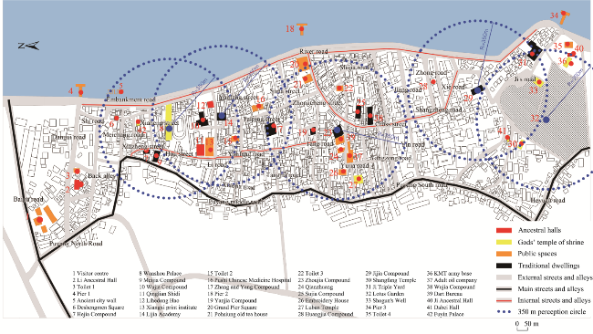
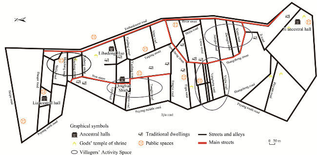
Figure 1 Distribution of spatial elements in Pushi Ancient Town |
Table 1 Classification of spatial perception elements in Pushi Ancient Town |
| Spatial structure characteristics | Form | Number* | Examples |
|---|---|---|---|
| Point-like spaces | Ancestral halls | 2, 11, 12, 40 | Li Ancestral Hall, Ji Ancestral Hall, Qinglian Shidi, etc. |
| God’s temple of the shrine | 8, 27, 30, 33, 36, 41, 42 | Wanshou Palace, Shangfang Temple, Luban Temple, Dabei Palace, etc. | |
| Public spaces | 1, 3, 4, 5, 6, 13, 15, 16, 18, 20, 21, 22, 24, 26, 32, 34, 35, 37, 39 | The visitor center, Pier, Ancient City Wall, Money Farm, Square, Lotus Garden, etc. | |
| Traditional dwellings | 7, 9, 10, 14, 17, 19, 23, 25, 28, 29, 31, 38 | Yanjia Compound, Jiajia Compound, Jijia Triple Yard, etc. | |
| Line-like spaces | External streets | Baipu Road, Puyang North Road, Puyang Middle Road | |
| Main streets | Hou Street, Shangzheng Street, River Road | ||
| Internal streets | Taiping Street, Tangjia Road, Zhongzheng Street, Jijia Road, etc. | ||
Note: The meaning of the numbers in this column refers to Figure 1. |
Table 2 Research indicator system and interpretation |
| Dimensions | Indicators | Translate | Interpretation or formula |
|---|---|---|---|
| Macroscopic | Densities | Measures the closeness and overall completeness of the connections between nodes in the network | P is the network density; L represents the number of connections present in the network; and n denotes the number of nodes |
| Mesoscopic | Lambda analysis | According to the degree of correlation (K value) between nodes, the network nodes are divided into different sets, thus reflecting the network hierarchical clustering relationship. In this case, the larger the K-value, the greater the degree of association and the more solid the structure of the relationship between the nodes | The edge correlation of any pair of points within the point set itself is greater than the edge correlation of any pair of points consisting of a point from the point set and a point external to the point set, and a point set can be said to be a Lambda set by satisfying the above condition |
| Microscopic | Proximity centrality | Denotes the sum of the shortest paths between a node and other nodes, with smaller values representing closer centrality | centrality of node i; signifies the shortest path length between node i and node j; n indicates the total number of nodes inside the network |
| Degree centrality | Measuring individual power in a spatial network presents the degree of linkage of individuals in the network | is the relative centrality of point i; is the absolute centrality of point i (i.e., the degree of the point) |
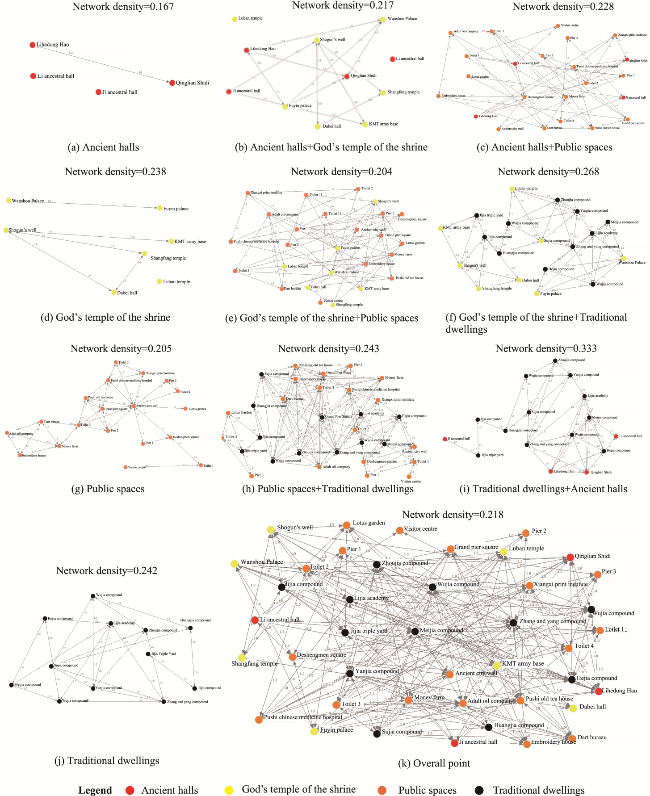
Figure 2 Point-like space spatial social network topology |
Figure 3 Point-like spaces spatial network clustering map |
Table 3 Mean statistics of point-like spaces spatial hierarchy parameters |
| Parameters | Types | |||
|---|---|---|---|---|
| Ancient halls | God’s temple of the shrine | Public spaces | Traditional dwellings | |
| Proximity centrality | 4.000 | 12.000 | 44.105 | 67.000 |
| Degree centrality | 0.667 | 1.200 | 2.667 | 3.684 |
Note: The values in the table are averages of four types of point spaces. |
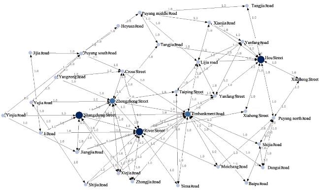
Table 4 Statistics on the current status of some line-like spaces in the ancient town of Pushi |
| Name | Width | Length | Properties |
|---|---|---|---|
| Shangzheng Street | 3-6 m | 520 m | Stone road, front shop, back house, and imitation ancient buildings (e.g., Sujia courtyard, Wujia compound, etc.) |
| Hou Street | 2-4 m | 310 m | Stone road, front shop, and back house, with historical buildings (e.g., Qinglian Shidi, Xiangxi painting house, Meijia compound, etc.) |
| River Street | 4-8 m | 750 m | Concrete road, near the Yuan River |
| Tangjia Street | 2-3 m | 185 m | Stone-paved roads, residential houses, mostly historical buildings (e.g., Zhoujia compound, dart boards, money farm, etc.) |
| Zhongzheng Street | 5-7 m | 500 m | Stone Road, front shop, back house, antique buildings |
| Yangzong Street | 2-4 m | 140 m | Stone road, shops, modern buildings |
| Taiping Street | 2-5 m | 230 m | Slate roads, shops, and antique buildings (e.g., Pushi Chinese Medicine Hospital, Lijia Academy, Wu’s compound, etc.) |
| Cross Street | 7 m | 230 m | Asphalt road, commercial, modern buildings |
| Jijia Street | 2-3 m | 220 m | Stone road, front shop and back house, antique buildings (Jijia compound, Jijia triple compound, etc.) |
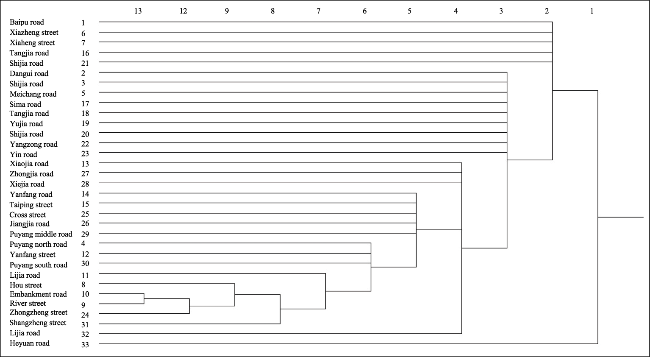
Figure 4 Line-like space spatial structure network topology diagram |
Figure 5 Line-like space spatial clustering map |
Figure 6 Point-like spaces and line-like spaces texture map |
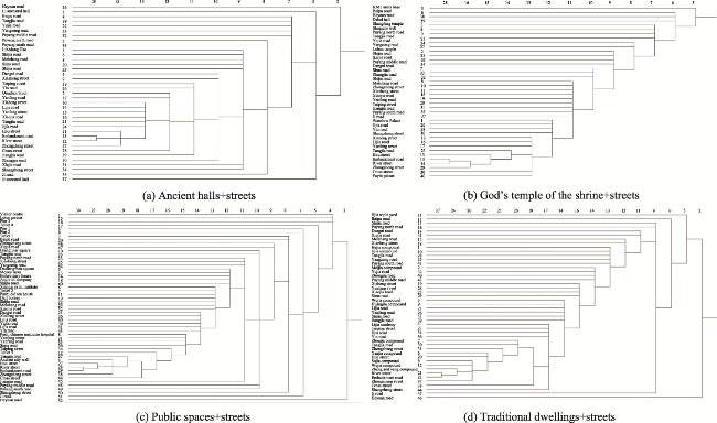
Figure 7 Point-like space and line-like space network topology diagrams |
Figure 8 Point-like space and line-like space cluster analysis |
Table 5 Mean statistics of point-space and line-space rank parameters |
| Parameters | Types | |||
|---|---|---|---|---|
| Ancient halls + streets | God’s temple of the shrine + streets | Public spaces + streets | Traditional dwellings + streets | |
| Proximity centrality | 65.500 | 68.947 | 97.654 | 75.422 |
| Degree centrality | 10.722 | 11.053 | 13.137 | 15.422 |
Note: The values in the table are averages of four types of point spaces. |
| [1] |
|
| [2] |
|
| [3] |
|
| [4] |
|
| [5] |
|
| [6] |
|
| [7] |
|
| [8] |
|
| [9] |
|
| [10] |
|
| [11] |
|
| [12] |
|
| [13] |
|
| [14] |
|
| [15] |
|
| [16] |
|
| [17] |
|
| [18] |
|
| [19] |
|
| [20] |
|
| [21] |
|
| [22] |
|
| [23] |
|
| [24] |
|
| [25] |
|
| [26] |
|
| [27] |
|
| [28] |
|
| [29] |
|
| [30] |
|
| [31] |
|
/
| 〈 |
|
〉 |
