Human Activities and Sustainable Development

Identification of Popular Areas for Hiking Tourism in Northwest Yunnan and Their Opportunities for Villagers to Increase Their Income

  • ZHAO Ouyi ,
  • WANG Jiaxue , *
Expand
  • Faculty of Geography, Yunnan Normal University, Kunming 650500, China
* WANG Jiaxue, E-mail:

ZHAO Ouyi, E-mail:

Received date: 2024-04-02

  Accepted date: 2024-12-20

  Online published: 2025-05-28

Supported by

Yunnan Provincial Department of Culture and Tourism Project(01300206020618018)

Abstract

Promoting sustainable livelihoods for villagers is an essential strategy for rural revitalization in areas enriched with heritage sites. Northwest Yunnan, despite being one of China’s poorest regions, is globally renowned for the Three Parallel Rivers and its premier hiking destinations, so exploring sustainable income-increasing opportunities for its villagers is important for its rural revitalization. By using density analysis, logical matrix construction and cluster analysis with GPS data, this study explored the spatial distribution characteristics of hiking tourism in Northwest Yunnan and identified the hiking popular areas. A revenue generation framework, informed by Sustainable Livelihood Approach (SLA) and customized to the unique hiking characteristics of such popular areas, was constructed to analyze income opportunities for villagers in these areas, so as to offer theoretical support for the hiking tourism development and rural revitalization in this region. The results showed that: (1) The distribution of hiking points of interest (POIs) in Northwest Yunnan was relatively centralized with three agglomeration areas from north to south, namely, the Deqin Agglomeration Area, the Lijiang-Shangri-La Agglomeration Area, and the Dali-Yangbi Agglomeration Area. (2) Northwest Yunnan mainly had three popular hiking areas and eight hiking sub-areas correspondingly. (3) The income-generating opportunities for villagers mainly included unique accommodation and food service, guide and gear transportation services, equipment supply, tourism product sales, and logistics support for hiking races. It indicated that due to the differing temporal-spatial characteristics, and themes of activities in each hiking sub-area, the approaches to revenue generation are uniquely distinctive for each sub-area. The diverse tourism-related livelihoods of villagers enrich tourists’ experiences while the nature of tourist activities guides the villagers’ livelihood choices. Hiking tourism serves as a vital avenue for economic growth in areas like Northwestern Yunnan, where villagers can significantly boost their income by offering a variety of tourism services.

Cite this article

ZHAO Ouyi , WANG Jiaxue . Identification of Popular Areas for Hiking Tourism in Northwest Yunnan and Their Opportunities for Villagers to Increase Their Income[J]. Journal of Resources and Ecology, 2025 , 16(3) : 655 -670 . DOI: 10.5814/j.issn.1674-764x.2025.03.005

1 Introduction

Rural revitalization plays an important role in the development of impoverished areas and the improvement of people’s lives. As livelihood is the cornerstone of well-being, the sustainable development of villagers’ livelihoods marks a vital route to achieving rural revitalization by breaking through the bottlenecks in agriculture, rural communities, and farmer welfare (Chen, 2023). However, the challenge of finding sustainable livelihoods opportunities in relatively impoverished World Heritage sites, while balancing conservation and development, presents a particularly thorny issue. Tourism greatly enhances the scale, scope, and intensity of human mobility, thereby making tourism flow a vital driver in the transformation and redevelopment of various areas (Wang et al., 2018). As an inherently eco-friendly and low-impact form of travel, hiking is considered a significant means to boost economic growth in mountainous regions under the premise of conservation (Boller et al., 2010). Understanding the distribution of hiking tourists assists in identifying well-known hiking spots, and tailoring the sustainable livelihoods framework according to the unique characteristics of each area contributes to directing the villagers towards enhancing their income by sustainable livelihoods.
Tourism flow, a geographical concept with distinct spatial attributes, was first introduced by Pearce and later elaborated by McIntosh (Pearce, 1987; McIntosh et al., 1994) as the directional movement of tourists from their origin to their destinations. Broadly, tourism flow encompasses the collective movement of tourists, funds, and information between destinations or between source and destination areas (Ma et al., 1999). In a narrower sense, it refers to the collective movement of tourists with similar needs, involving their travel routes, range, and behavioral patterns (Tang and Guo, 1998). Tourists are the primary agents of tourism activities, making tourist flow a central topic in tourism studies (Yan et al., 2017). Xu and Xie (1995) noted that tourism flow should be narrowly defined as the movement of tourists, and most researchers use passenger flow to represent and study tourism flow. Traditional tourism flow research mainly focuses on the spatial-temporal distribution and structure (Yan et al., 2017), network structure characteristics (Ji et al., 2017; Wang et al., 2021), scale prediction (Dai et al., 2018; Zhang and Zhao, 2020), and influencing factors (Song et al., 2021). With the advent of the internet and big data, data collection methods for tourism flow have shifted from traditional methods such as surveys (Zhang et al., 2024), statistical yearbooks (Cao and Tian, 2014), and travel agency routes (Peng et al., 2014) to digital footprints (Luo and Liang, 2016), geotagged photos (Lu et al., 2021), online travelogues (Wang et al., 2021), and social media data like Weibo (Yan et al., 2017; Cai et al., 2023).
The tourism industry is one of the fastest-growing sectors in terms of revenue generation and job creation. According to the 2019 report by the World Travel & Tourism Council on the impact of travel and tourism, the industry accounts for about 10.4% of global GDP and provides around 319 million jobs, equating to 10% of total global employment (Sanjeev and Birdie, 2019). Over the past two decades, tourism has made a substantial contribution to China’s economic growth. The World Travel & Tourism Council (WTTC) estimated that the industry’s direct and indirect impacts on the Chinese economy amounted to approximately 152 billion USD, creating 54 million jobs. Tourism not only generates employment through industrial linkages but also drives regional economic growth, encouraging villagers to engage in tourism activities, increase income, and reduce household poverty. This, in turn, significantly affects livelihood choices and the income of tourism communities. Liu et al. (2017) explained from the perspective of tourism flow direction effects that tourists often originate from wealthier domestic regions and travel to less developed areas, enabling tourism spending to transfer wealth from more to less developed regions. Truong et al. (2014) discovered that tourism holds the potential to significantly increase the absolute income of the impoverished population through semi-structured interviews with tourism consultants in Sapa, Vietnam, staff from the Vietnam National Administration of Tourism, and local university personnel. Wang et al., focusing on rural China, found that higher levels of specialization in tourism are associated with greater reductions in economic, environmental, and living poverty (Wang et al., 2020). Using panel data from 30 provinces in China from 1999 to 2008, Zhao confirmed that overall tourism development significantly boosts rural per capita income (Zhao, 2011). Current research on tourism and villagers’ income includes evaluating the effect of tourism on increasing villagers’ income (Guo and Li, 2016; Wu et al., 2022), analyzing factors and conditions that facilitate income enhancement through tourism (Li and Li, 2023), and exploring various pathways and models for income generation from tourism (Jiang, 2010; Sun et al., 2021). The primary tourism types contributing to income growth include rural tourism (Zhou et al., 2023), ecotourism, and heritage tourism (Chen, 2020). In the mentioned studies, only those related to ecotourism have included hiking as a type of ecotourism product, without specifically researching it as a significant form of tourism that can contribute to villagers’ income enhancement and rural revitalization. While hiking tourism and ecotourism both involve interacting with nature, they should not be conflated. Ecotourism emphasizes environmental conservation and educational purposes, whereas hiking tourism focuses more on physical activities and personal experiences in natural settings (Neupane, 2020). Precisely, hiking tourism is a form of outdoor, self-guided travel where walking is the primary mode of transportation across the majority of a destination’s areas (Jin et al., 2012).
Hiking has been one of the most popular outdoor tourism activities in Western developed countries for over twenty years. Statistical data shows that the proportion of the population participating in hiking is 44% in Switzerland (approximately 2.7 million people), 25% in France (approximately 16 million people) and 15% (about 47.86 million people) in America. Moreover, the percentage of the population aged 14 and above who hike is as high as 47% (approximately 38.84 million people) in Germany and 27.3% (approximately 5.3 million people) in Australia (Koenig, 2021). In recent years, developing countries like Nepal, Malaysia, Morocco, and China have witnessed rapid growth in hiking tourism, thanks to their rich natural and cultural resources and unique hiking trails. According to the “China Hiking Tourism Development Report (2019),” approximately 4% of the total population engages in hiking, indicating a vast potential for the expansion of hiking activities in China. Hiking tourism is now regarded as an effective way to develop local tourism, especially in remote mountainous areas endowed with natural or semi-natural landscapes. These regions often have high tourism potential, and since hiking aligns with sustainable development strategies, promoting hiking tourism becomes a crucial path to economic growth in these areas. By providing facilities and services for hikers, a significant amount of employment and income opportunities can be generated for the local economy (Boller et al., 2010). Research on the relationship between hiking tourism and villagers’ income encompasses areas such as community participation systems and their evolution (Guo, 2010), livelihood changes (Gurung and Seeland, 2008), and tourism-based poverty alleviation (Li et al., 2012). A commonality in these studies is the use of similar research methods, including observation, surveys, in-depth interviews, and literature review. Case studies often focus on destinations like Yubeng, known for their significant community involvement in tourism benefit-sharing mechanisms. Li and Yang (2010) argued that a community-led model for tourism can ensure greater fairness in participation opportunities and income distribution, but it may lead to inefficiencies in the development of the tourism economy. Previous studies have mainly focused on the fairness of income distribution from the villagers’ perspective, with less consideration given to the efficiency of income generation in relation to the needs of hikers. In addition, giving much attention to unique areas like Yubeng as case studies can lead to other regions blindly copying this model, ignoring developmental differences and resulting in severe homogenization. In contrast, by adhering to the principle of “maximizing similarity within a region and minimizing it between neighboring regions”, identifying and delineating popular tourism areas dose contribution to clearly defining the development direction and functional positioning of regional tourism (Liu and Wang, 2007). It guides villagers in seeking income opportunities, enabling them to offer services and products that meet market demands while leveraging their unique strengths.
Rural revitalization is vital for the advancement of underprivileged areas and the uplift of people’s living conditions, following the successful conclusion of the poverty alleviation campaign and the achievement of a moderately prosperous society. It aims to enhance the overall development of impoverished areas by addressing agricultural, rural, and farmers’ shortcomings, ultimately achieving common prosperity for all the people. Northwest Yunnan, located in the western border of China, has long been an economically and socially disadvantaged area within Yunnan Province and the nation as a whole due to its unfavorable location and special geographical environment. The region suffers from weak infrastructure and a significant lag in economic development (Pu and Bai, 2015). Due to its fragile ecological environment, a large population of ethnic minorities, and the significant challenges it faces, the income of residents there remains relatively low compared to other regions in Yunnan (Li et al., 2020). The path to rural revitalization in Northwest Yunnan is still a long and arduous journey.
Given the abundant tourism resources in Northwest Yunnan and the strict limitations imposed by natural conditions and spatial planning on the development of other industries, the development of the tourism industry has become the obvious choice for local economic revitalization and cultural rejuvenation (Zhang and Xiong, 2015). With the ongoing transformation of the tourism industry in Yunnan Province, Northwest Yunnan is also in the process of transitioning its outdoor tourism sector towards green, healthy, and sustainable practices. Hiking tourism, as a low-barrier and widely appealing form of travel, holds immense development potential. There is significant untapped potential in the cultivation of the hiking tourism consumer base, which, in turn, offers substantial income-generating opportunities for local villagers (An, 2017). The exceptional natural environment in Northwest Yunnan provides a unique resource for the development of outdoor tourism. Renowned hiking destinations such as Meili Snow Mountain, Shangri-La, and Tiger Leaping Gorge exhibit significant brand effects, exerting considerable influence on the advancement of regional hiking tourism (Ji, 2021). In a region like Northwestern Yunnan, characterized by its vast area and rural or suburban landscape, tracking hikers and gathering their needs using traditional methods is challenging due to the dispersion of tourists and numerous trails. GPS data, real-time recorded and uploaded by hikers to outdoor social platforms, offers accurate, rich, and timely hiking information and provides reliable resources for identifying various characteristics of hiking tourism. Utilizing GPS data to identify popular hiking areas and exploring the differences among them can effectively uncover income opportunities for villagers in each hiking zone. This approach maximizes the use of local resource advantages, enhances villagers’ income levels, and drives rural revitalization.
With Northwest Yunnan as the study area, density analysis is utilized based on the GPS, to explore the spatial distribution characteristics of hiking tourism in Northwest Yunnan. Then the popular hiking areas are identified by the means of logical matrix construction and cluster analysis. A revenue generation framework is constructed to analyze income opportunities for villagers in these areas, so as to offer theoretical support for the hiking tourism development and rural revitalization in this region. Building upon such analysis, the income generation possibilities among local villagers are explored according to the revenue generation framework constructed by referring to the Sustainable Livelihoods Approach developed by the British Department for International Development (DFID-SLA), with the ultimate aim of offering theoretical insights for the development of hiking tourism and rural revitalization in Northwest Yunnan.

2 Materials and methods

2.1 Study area

Northwest Yunnan is situated at the southwestern border of China, along the southeastern edge of the Qinghai-Tibet Plateau, in the region of the Hengduan Mountains. It shares its northern border with the Tibet Autonomous Region and Sichuan Province, while its western border adjoins Myanmar. To the east, it borders Chuxiong Autonomous Prefecture, and to the south, it shares boundaries with Baoshan City, Lincang City, and Pu’er City. This region includes Dali Bai Autonomous Prefecture, Deqin Tibetan Autonomous Prefecture, Nujiang Lisu Autonomous Prefecture, and Lijiang City, encompassing a total of 24 counties and autonomous counties. The overall land area measures approximately 88632 km2, accounting for 22% of the entire province, with a total population of 5.635 million, representing around 12% of the provincial population (Ming and Tong, 2016).
The disadvantaged location and unique geographical environment of Northwestern Yunnan have historically made it one of the less developed areas in Yunnan and across China, economically and socially. The region suffers from weak infrastructure and significantly lagging economic development (Pu and Bai, 2015). However, this region boasts abundant tourism resources, such as the World Natural Heritage “Three Parallel Rivers”, the World Cultural Heritage Old Town of Lijiang and the World Memory Heritage Naxi Dongba Literature Manuscripts (Li, 2021). The region is home to several perennially snow-capped mountains, such as Jade Dragon Snow Mountain, Haba Snow Mountain, Baima Snow Mountain, and Meili Snow Mountain, which are among the world’s lowest latitude snow-capped mountains in the Northern Hemisphere. Inhabited by various ethnic groups, including the Bai, Naxi, Lisu, and Dulong ethnicities, the region boasts diverse cultures with distinctive characteristics (Liu and Wang, 2014). Blessed with unique natural landscapes and rich, diverse ethnic cultures, Northwestern Yunnan sees tourism as a key livelihood strategy for many villages and towns, leveraging the industry’s low entry barriers, quick return on investment, and strong comprehensive economic impact (Sun and Liu, 2015).
Its significant scientific value, aesthetic significance, and unique minority cultures hold immense appeal for hikers seeking unspoiled natural beauty. Destinations such as Meili Snow Mountain, Tiger Leaping Gorge, Shangri-La, Lugu Lake, Old Town of Lijiang, Jade Dragon Snow Mountain, Haba Snow Mountain, Cangshan Mountain, Nujiang River, Dulong River, Biluo Snow Mountain, and Gaoligong Mountain are all highly renowned among hiking enthusiasts (Zhao and Wang, 2023). Hiking tourism has become a vital pathway for economic development and rural revitalization in Northwestern Yunnan. The region’s underdeveloped economic status, coupled with its rich tourism resources and potential hiking development, make it an excellent case study for researching income opportunities for local villagers in hiking tourist areas.

2.2 Data source and processing

The administrative division data used in this study was based on the standard map basemap provided by the Geographic Information Bureau of the National Bureau of Surveying and Mapping (http://bzdt.ch.mnr.gov.cn/). The GPS data for this study was obtained from the “2bulu” outdoor tourism website (https://www.2bulu.com/). A total of 9929 hiking trajectories, 180 599 points and related information like hiking dates in Northwest Yunnan were collected from the website, covering four prefectures and cities, namely Dali Bai Autonomous Prefecture, Lijiang City, Deqin Tibetan Autonomous Prefecture, and Nujiang Lisu Autonomous Prefecture.
To ensure the authenticity and accuracy of the collected data, this study adopts the following filtering rules: (1) Data from 2010 to 2022 were selected to analyze the overall development of hiking tourism in Northwestern Yunnan over a decade. Any spatial unit frequently traversed by the same trajectory during this period was considered part of a closely connected hiking sub-area; (2) Data outside the study area was removed; (3) Trajectories not intended for hiking tourism, such as those labeled for surveys or maintenance work, were excluded; (4) Data missing key attributes like hiking time, or those with duplicate attributes, were deleted; (5) Abnormal data with speeds exceeding 15 km/h was also removed. Subsequently, the “Join” tool in ArcGIS 10.4 was employed to connect the trajectory routes with associated points and related information in accordance with their common names. This process resulted in a final dataset comprising 3376 trajectories, with a total of 171158 associated points.

2.3 Methods

2.3.1 Kernel density analysis

Kernel density analysis is a vital spatial analysis method in GIS. It involves calculating the density of discrete elements, including point and line features, within their surrounding neighborhoods. This process generates a smooth two-dimensional surface, with the surface values peaking at the locations of the features and gradually decreasing as the distance from the features increases. It is used to assess the spatial aggregation and dispersion patterns of these features (Silverman, 1986). The formula is:
λ ^ h ( s ) = i = 1 n 3 π h 4 1 ( s s i ) 2 h 2 λ 2
where, λ ^ h ( s ) represents the estimated density at location s; n represents the number of points to be studied, h represents the location of the i-th point feature within a radius spatial range; s represents the location of the point feature under estimation; si represents point features falling within a circular area centered at s; λ represents the kernel function parameter that adjusts the smoothness of the density estimate.

2.3.2 Logical matrix method

In a given region, the connection between different spatial units occurs when the same recreational route traverses them (Jansen-Verbeke and Spee, 1995). The strength of spatial unit connections directly determines the delineation of hiking areas (Liang et al., 2019). Townships represent the most basic administrative units in China and play a foundational role in rural and national socio-economic development. Dividing hiking tourism areas based on townships facilitates the systematic management of hiking tourism using existing administrative resources, thereby avoiding issues arising from incongruent boundaries and unclear responsibility divisions.
In this study, townships were taken as spatial units, and the strength of their connections was measured by the number of shared hiking trajectories passing through them. A logical matrix of size i×j was constructed, where i represents spatial units and j corresponds to hiking trajectories. If trajectory j passes through township i, the value Cjk is marked as “1”; otherwise, it is designated as “0”.

2.3.3 K-means clustering

The K-means clustering is a typical distance-based clustering method that employs distance as the evaluation metric for similarity. During the clustering process, several points that are close in distance will be grouped into the same cluster, while those far apart will be assigned to different clusters (Li et al., 2019). In this study, the K-means clustering method from SPSS software was utilized to identify hiking tourism popular hiking areas in Northwest Yunnan. The constructed logical matrix served as input data for K-means clustering, using the squared Euclidean distance as the clustering criterion to measure the dissimilarity between different spatial units. Spatial units that share more common trajectories are considered to have higher tourism connections and, consequently, lower dissimilarity. They exhibit more similar characteristics, making them more likely to be assigned to the same hiking area (Liang et al., 2019). During clustering, the best K value for delineating hiking tourism areas in Northwest Yunnan was determined by seeking the finest classification within an interpretable range.

3 Results

3.1 Density characteristics of hiking POIs

As shown in Figure 1, the distribution of hiking POIs in Northwest Yunnan is relatively concentrated with three agglomeration areas from north to south, namely, the Deqin Agglomeration Area, the Lijiang-Shangri-La Agglomeration Area, and the Dali-Yangbi Agglomeration Area. Specifically, the Dali-Yangbi Agglomeration Area is roughly centered around the Eight Peaks of Cangshan, with Dali Town and Yinqiao Town as the main hubs. It extends to include towns along the Erhai Lake coast, such as Xiaguan Town and Xizhou Town, as well as Cangshan West Town to the west of Cangshan.
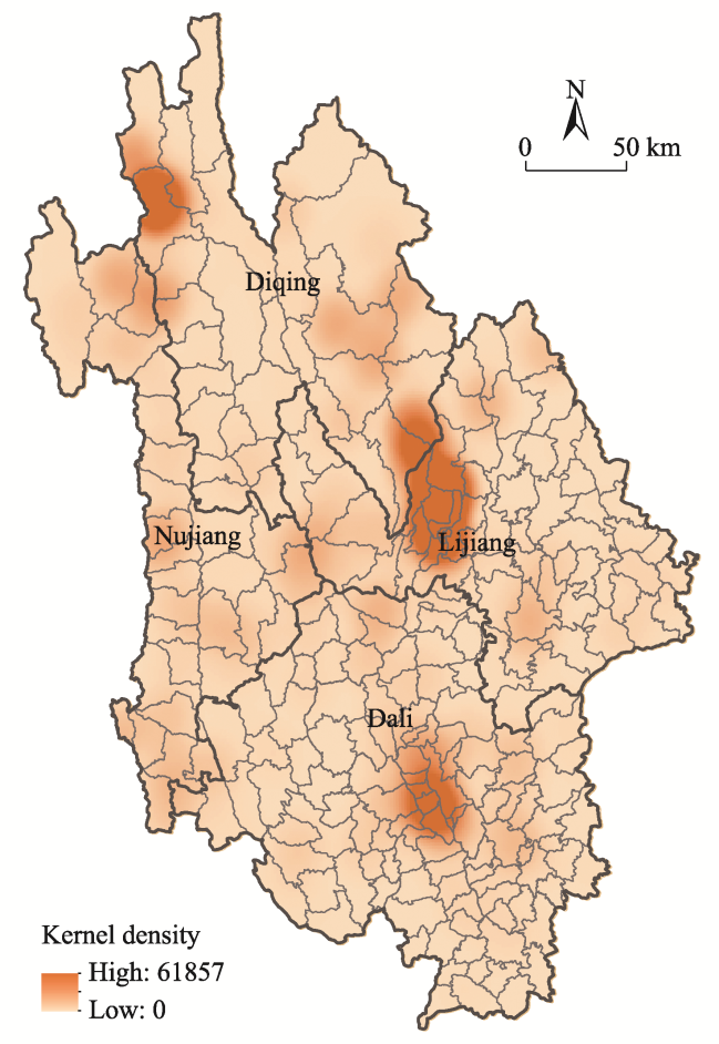
Figure 1 Hiking POI kernel density in Northwest Yunnan
The Lijiang-Shangri-La Agglomeration Area consists of a primary hub centered around Jade Dragon Snow Mountain and Old Town of Lijiang, as well as a secondary hub focused on Tiger Leaping Gorge. The primary hub includes areas like Baisha Town, Dayan Street, Huangshan Town, Lashi Town, Shuhe Street, Xi’an Street, and Xianghe Street. The secondary hub encompasses Tiger Leaping Gorge Town and Longpan Township, among others. The Deqin Agglomeration Area aligns closely with the region of Meili Snow Mountain and encompasses areas such as Yunling Township and Foshan Township.

3.2 Identification of popular hiking areas

Considering the research scale and objectives, results with cluster numbers ranging from five to twenty-five were generated as alternatives. The corresponding Silhouette scores for each cluster number were calculated, and a K value of nine yielded a silhouette coefficient of approximately 0.4, indicating an ideal clustering result (Figure 2). Each cluster could be reasonably interpreted, and there were substantial differences between the clusters. Therefore, a cluster number of nine was selected.
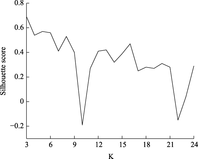
Figure 2 Silhouette coefficient analysis of clustering in Northwestern Yunnan hiking area
The nineth cluster contained townships scattered in their locations, with few trajectories passing through them. As a result, most of their Cjk values turned to 0, indicating high similarity among them. During clustering, these townships were grouped into a single cluster with significant dispersion and lacking apparent spatial clustering. Therefore, it was considered an outlier and excluded from the study. Figure 3 revealed the final clustering results. Northwest Yunnan had three major hiking areas: the Northern, the Central, and the Southern, along with eight subzones. The Northern Hiking Area consists of Hiking Sub-area (1). The Central Hiking Area is composed of Hiking Sub-area (2), (3), (4), (5), and (6). The Southern Hiking Area includes Hiking Sub-area (7) and (8). The number of hiking trajectories for different months in each hiking sub-area was calculated (Figure 4). By comparing the spatiotemporal hiking behavior of different hiking sub-areas, the theme of each of them were assigned (Table 1).
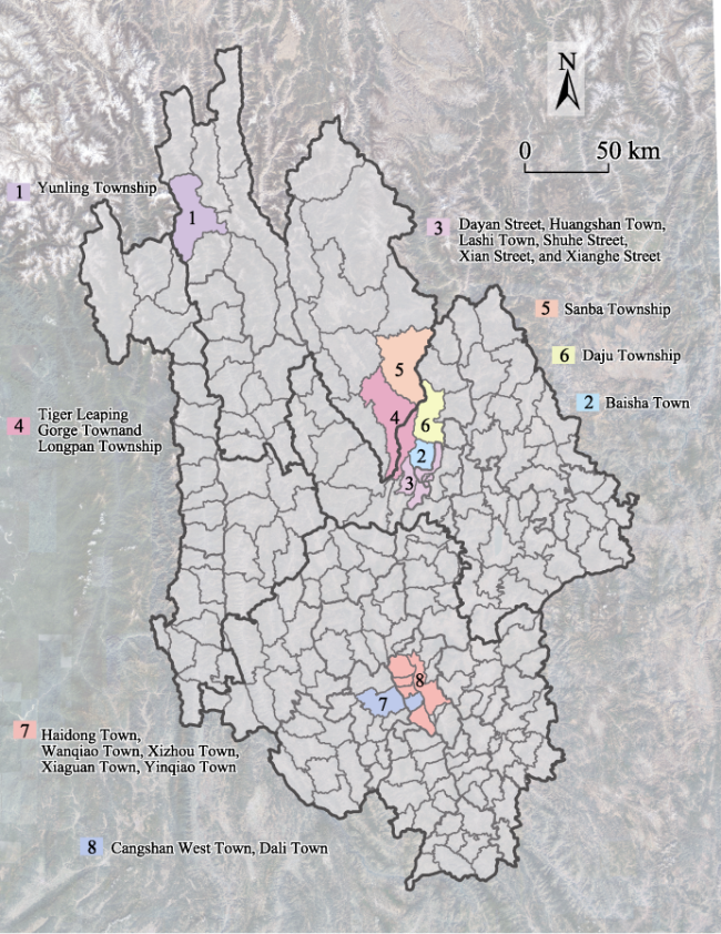
Figure 3 Clustering of hiking areas
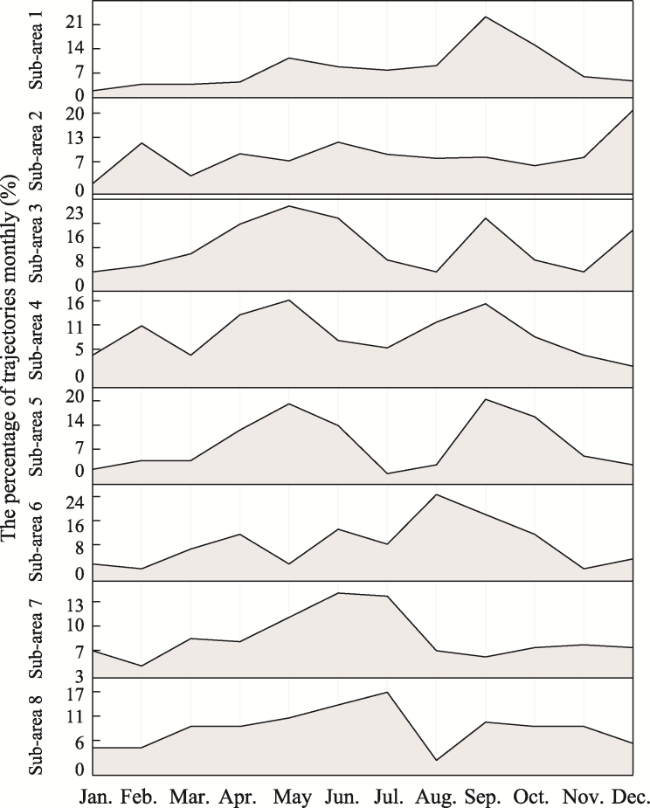
Figure 4 The percentage of trajectories monthly for each hiking sub-area
Table 1 Characteristics and themes of hiking activities in each sub-area
Hiking areas Sub-areas Spatial characteristics Temporal characteristics Themes
North 1 Hiking around mountains but not reaching the summit August-October, followed by May- June Snow mountain exploration
Pilgrimage hiking,
Spring and autumn flower viewing
Winter sun observation
Center 2 Hiking at altitudes above 3000 meters without summit activities peak month in December Mountain climbing
Meadow crossing
Forest oxygen bath
Spring flower appreciation
Old town strolling
3 Hiking around lakes or in the ancient town without summit activities April-June Exploring ancient pathways
Strolling through ancient towns
Flower and mushroom picking
Photography and bird watching
4 Hiking around rivers without summit activities April-May followed by August-September Distance viewing of snow-capped mountains
Cliff hiking
Spring flower appreciation
Summer wave listening
5 Hiking to reach the summit April-June and September-October Easy hiking
Spring flower appreciation
Overlooking the sea of clouds
Camping adventure
6 Hiking to reach the summit August-October Summiting the peak
Enjoying distant views of the snow-capped mountains
Snow mountain photography
South 7 Hiking around lakes with summit activities May-July followed by March-April Leisurely hiking
Rice field photography
Stream tracing with waterfall gazing
Ascending peaks through stone steps
8 Hiking in the mountains with summit activities May-July followed by March-April Leisurely hiking
Stream tracing
Temple visits
Vegetarian dining
Spring and summer flower appreciation
Geological study tours
The first sub-area is located in Yunling Township, Deqin County. It is renowned for the “Yubeng Hiking Route” that traverses the Meili Snow Mountain range. Considering the seasonal distribution of trajectories, the peak hiking season primarily falls in May and from August to October. Hiking trajectories make up over 10% of the total in almost every month, with September exceeding 20%. It might due to the fact that Yunling Township lies to the west of the eastern hills of Meili Snow Mountain with various sceneries of flowers and plants in spring and autumn. In May each year, the area is lush with rhododendrons covering the hillsides. In September and October, buckwheat flowers bloom, and the oleander turns red. During this time, Yubeng transforms into a sea of flowers with stunning and richly layered scenery. On the contrary, from June to August, it is the local rainy season with concentrated precipitation, making it a climate-sensitive area for mountaineering. After October, precipitation decreases, and there are more sunny days, making it the perfect season to enjoy the sight of the sun shining on the golden mountains. Although there is a higher probability of seeing this phenomenon in January, it’ is also prone to snowfall and road closures. This hiking sub-area primarily focuses on mountain circuit hikes. Due to local legislation prohibiting the ascent of the main peak of Meili Snow Mountain, there is no summiting activity in the area. The main hiking themes include snow mountain exploration, pilgrimage hiking, spring and autumn flower appreciation, and winter sun observation. Therefore, this sub-area is called Meili Snow Mountain Hiking Sub-area.
The second sub-area is located at the southern foothills of the Jade Dragon Snow Mountain and includes only one spatial unit, Baisha Town. Its distribution of hiking activities by season is relatively even, with a peak occurring only in December, accounting for 20%. This hiking sub-area is suitable for visits throughout the year, but it is most popular in November and December. During this time, there is heavy snowfall, creating stunning snowscapes, making it the best season for both sightseeing and photography. There are extreme values in February and June. In February, temperatures are still low, providing the opportunity to experience thrilling skiing while enjoying the snowy scenery. June is the peak tourist season, with many visitors heading to Baisha Ancient Town. However, due to the rainy season and minimal snowfall during this time, it is not suitable for climbing Jade Dragon Snow Mountain. Given the above reasons, the sub-area is named as Jade Dragon Snow Mountain Hiking Sub-area. Overall, this sub-area offers varied seasonal experiences: in spring, it is ideal for a romantic and colorful eco-hike through blooming landscapes; in summer, one can enjoy leisurely strolls in the comfortably cool and misty ancient town of Baisha; and in winter, it becomes a perfect spot for mountain climbing, skiing, and photography, making it a year-round hiking destination.
The third sub-area is located in Old Town of Lijiang and includes famous attractions such as Dayan Old Town and Shuhe housing clusters. From April to June, it is the peak period for hiking activities, with spikes occurring in September and December. April and May offer the most beautiful scenery in the old town, where hikers can leisurely stroll through the ancient city with its charming small bridges and flowing streams. Late spring is the best time to appreciate the blooming flowers around Lashihai Lake, with thousands of peaches and roses in various colors. During the summer, the old town experiences its rainy season, allowing hiking tourists to enjoy the misty charm of the ancient city and explore the Tea Horse Ancient Road. September brings clear skies and lush greenery, with cool autumn weather and golden maple leaves falling in the ancient city. December transforms Lashihai Lake into a “bird paradise”, making it the best time for bird watching and photography. Due to the above reasons, the name Old Town of Lijiang Hiking Sub-area is given to this sub-area.
Sub-area four is located near Tiger Leaping Gorge. From April to May, the climate is comfortable with clear skies. The meadows are adorned with vibrant flowers, creating enchanting scenery. It’s also an ideal time to appreciate the tranquil and lush greenery of the Jinsha River around Tiger Leaping Gorge. In August and September, influenced by heavy rainfall, the water levels in the upper reaches of the river rise dramatically. It vigorously crashes against the rocky cliffs on both sides, allowing hikers to experience the tumultuous and majestic nature of Tiger Leaping Gorge, complete with the roaring sounds of the turbulent waters. Consequently, the sub-area is named as Tiger Leaping Gorge Hiking Sub-area.
The fifth sub-area is located at the foot of Haba Snow Mountain and includes major hiking destinations such as Haba Snow Mountain and Black Lake. Hiking activities are concentrated mainly in the periods of April to June and September to October, with peaks occurring in May and October. These two months offer favorable temperatures, lower precipitation, and pleasant scenery. Haba Snow Mountain Natural Reserve is a paradise for various species of rhododendrons and is home to over a dozen varieties of wild rhododendron flowers. In May, rhododendrons bloom gradually from the village of Haba at an altitude of 2700 m to the high-altitude lakes at 4200 m. By October, Haba Snow Mountain becomes colorful with orange and yellow tall trees, warm-colored fallen leaves, complemented by white sheep, black cattle, and Yi ethnic pastoralists dressed in red and blue attire. At an altitude of 4200 m on the shores of Black Lake, the blooming Nepal rhododendron flowers and the magnificent reflection of snow-capped mountains in the tranquil lake waters can be admired. Hence, the sub-area is named as Haba Snow Mountain-Sub-area.
The sixth sub-area is situated to the east of Jade Dragon Snow Mountain and includes prominent attractions like the Snow Lotus Peak of Jade Dragon Snow Mountain and Maoniuping. Known for its high mountain meadows and stunning natural beauty, Maoniuping is an ideal destination for hiking and various outdoor activities. Hiking activities are concentrated from August to October, with August being the peak month, and minor peaks occurring in April and June. During the summer season, Maoniuping serves as an exclusive pasture for Tibetan herders in the mountains. Hikers can experience the pastoral culture, enjoy picturesque meadows, vibrant mountain flowers, and extensive fir forests. Snow Lotus Peak is the prime location for viewing the Thirteen Peaks of Jade Dragon Snow Mountain and offers distant vistas of Haba Snow Mountain to the north. Accordingly, this sub-area is entitled as Snow Lotus Peak Hiking Sub-area.
The seventh sub-area, situated along the coast of Erhai Lake in Dali, is renowned for its stunning azure lake and picturesque mountain scenery at the foot of the Cangshan Mountains. It is an ideal spot for lakeside hiking and mountain climbing. The sub-area experiences its peak season from May to July and a secondary peak season from March to April, offering ideal weather and splendid natural beauty for hiking and outdoor activities. Shuanglang on the east coast offers picturesque lake views, creating a “Divine Light of Erhai Lake” effect when sunlight filters through the clouds onto the lake, creating a stunning visual effect against a backdrop of continuous mountains. This scenic beauty makes it an ideal location for photography enthusiasts seeking to capture natural landscapes. From April to July, the landscape turns lush green, where blue waters meet the sky and rice fields. The northern peaks of Cangshan Mountain are dotted with forests, grasslands, and streams. Hiking activities decrease in August, likely due to excessive rainfall affecting the scenery. The area around Erhai Lake also offers various tourism services and activities like lake cruises and photography tours around Erhai Lake.
The peak hiking season for the eighth is from May to July, followed by March to April as the secondary peak period. In May, various species of rhododendrons bloom in full splendor on the summit of Cangshan. In late spring and early summer, the weather is usually clear and pleasant, with lush vegetation along the hiking trails. Walking on these trails feels like being in a natural oxygen bar. On clear days, hikers can enjoy panoramic views of Erhai Lake and the picturesque scenery of Dali. Cangshan features numerous streams flowing between its peaks, and hidden within the mountains are various temples. During the leisurely hike, hikers can escape the hustle and bustle of everyday life, visit temples, and savor vegetarian meals, seeking moments of inner tranquility. With an average summer temperature of 19 ℃, Cangshan is an ideal place to escape the summer heat. Additionally, its magnificent summer landscapes attract many hiking enthusiasts. Thus, the name Cangshan Hiking Sub-area is given to this sub-area.
Overall, the peak period for hiking activities in the 8 sub-areas of Northwest Yunnan is primarily during late spring and early summer, aligning with its general climatic characteristics. Hikers tend to prefer seasons characterized by clear skies and minimal wind, avoiding the rainy season and colder weather.

3.3 Income opportunities for villagers

Hiking tourism, as a sustainable mode of travel and a means to distribute tourist flow, has globally created substantial economic and social benefits. It significantly contributes to job creation, economic growth, environmental sustainability, rural development, and income diversification (Arabatzis and Grigoroudis, 2010; Stoeckl et al., 2010; Lukoseviciute et al., 2022). The 1998 United Kingdom (UK) Day Visits Survey showed that 35% of countryside visits in England had walking as the main activity (Sandbach et al., 2001). New Zealand, a renowned international hiking destination, sees hikers spending more time and money than other tourists, according to the local tourism board. On average, hikers spend about 3000 USD per visit, compared to US$2800 for other tourists, with their stays averaging 19 days versus 16 days for non-hiking visitors. In Peru, international hikers spend an average of 130 to 150 USD per day, benefiting many tour operators and travel agencies. In African countries like Uganda and Rwanda, the cost for gorilla hiking tours in 2020 ranged from 600 to 1500 USD per person per hour, lasting 10 to 15 days. To aid gorilla conservation, 10% to 20% of tourism revenue is returned to the local communities (Koenig, 2021). Different regions have diverse resource environments and hiking activities, leading to varied income generation methods and opportunities for villagers.
Traditional research often uses the DFID-SLA framework to analyze livelihood strategy choices, measuring livelihood capitals including human, physical, and financial aspects. This approach considers factors affecting villagers’ livelihood capabilities but overlooks external market demands, lacking specificity. Hiking tourism, deeply reliant on natural environments, sees its income generation heavily influenced by environmental characteristics and tourist demands. Building on the DFID-SLA framework, this paper introduces improvements from the demand side, replacing livelihood capital with tourism activity characteristics, including the peak period of activities, spatial features, and themes. Using classification methods and bases from previous research, and considering the common patterns in the development of eight major hiking sub-areas, villagers are categorized into tourism-led, tourism-employed, and other types (Xu and Bao, 2022; Zheng and Wu, 2023). Sustainable tourism income results encompass job creation for villagers, personal income promotion, and overall economic growth in villages. A systematic framework for tourism income generation is summarized by referring to typical domestic and international tourism income-generating experiences and cases (Table 2). In order to broaden and innovate income-generating channels, the types of tourism in the cases in the table are expanded to those closely related to hiking tourism, such as rural tourism, eco-tourism and outdoor tourism.
Table 2 Revenue generation framework
Tourism
destination
Characteristics of tourism activities Livelihood strategies Tourism income
results
Peak season Space Theme Tourism-led Tourism-employed Others
Lake Tana Biosphere Reserve in Ethiopia
(Bires and Raj, 2020)
Early Oct. Lakes
Islands
Monasteries
Boating
Sacred sites visiting
Hiking
Bird watching
Photography
Fish products
Souvenir shops
Hotels
Restaurants
Travel agencies
Handicrafts
Boatman tour guides
Hotel staff
Restaurant staff
Travel agents
- Tourism-involved households: 45.2% earn >10001 ETB/year
Non-tourism households: Average <10000 ETB/year
Shikoku Pilgrimage Hiking Trail in Japan
(Tian, 2019)
Apr.-May
Oct.-Nov.
The 88 sacred sites on
Japan’s Shikoku Island linked to the Kobo Daishi
Spiritual pilgrimage
Temple blessings
Forest hiking
Island sightseeing
Old street strolling
Shelter
Accommodation
Supply point
In summer and winter: Non-mountainous area guides
Mountain guides
Mountaineering guides across Japan
High-altitude guides
- 100-120 USD per hiker per day
Kabaka heritage trail in Uganda (Ahebwa et al., 2016) Year-round Tombs
Palace
Mosques
Cultural performance
Traditional culture tour
Coffee tasting
Hundred stairs climbing
Souvenir stores
Restaurants
Traditional clothing stores
Tour guides
Cultural dancers
Ticket sales
- 61.7% families: 36-179 USD monthly
18.4% families: 179-357 USD
6.8% families: >357 USD
Hetu Town in Anhui (Su et al., 2019) Apr-Oct., esp. Jun.-Aug. Mountain peaks
Forests
Reservoirs
Hiking to enjoy flowers
Watching clouds and mist
Rafting
Fishing
Restaurants
Country family inns
Agritourism
Transportation
Specialty stores
Sanitation worker
Gardener
Tour guides
- Over 60000 tourist visits
Income increased in 68.9% families
Aoluguya Community in Inner Mongolia (Rongna and Sun, 2022) Jul.-Sep., Dec.-Jan. Forests
Grasslands
Wetlands
Reindeer culture visit
Birch bark culture
experience
Feeding reindeer
experience
Tourist product shops
Inns
Reindeer display
Reindeer food sales
Employment in scenic areas or tourism
companies
Reindeer photography
- Over 1.35 million tourist visits
Lujia Village in Zhejiang (Li et al., 2023) Sep.-Nov. Farm
Field
Village
Tour train
Woodcraft and white tea culture experience
Local food tasting
Agricultural culture experience
Cycling to enjoy autumn
Camping
Family farm
Homestays
Agritourism
Local specialty stores
Camping sites
Staff for farms Land
transfer and rental
Collective equity
dividends
Per capita income
increase: from 14719 yuan in 2011 to 49850 yuan in 2021;
Gross output value growth: from 217.7 million yuan in 2016 to 244.1 million yuan in 2018
Hailuogou Scenic Area in Sichuan (Liu et al., 2019) Feb., Jul.-Aug., Oct. Snow
mountain
Park
Cable car
Glacier sightseeing
Hot spring bathing
Tibetan and Yi cuisine tasting
Spring flower viewing
Inn and restaurant
Agritourism
Tourist specialty products
Hot spring bath
Rural transportation
Restaurant and hotel services
Horticultural pruning
Carrying stretchers
Scenic area ticket sales
- Over 1.26 million tourist visits average annual cash income per tourism- involved household: 91800 yuan;
Total tourism income: 1.25 billion yuan in 2015
Azheke Village in Yunnan (Xu and Bao, 2022) Dec.-Mar.
Sep.-Oct.
Village roads and
alleys
Terraced fields
sightseeing
Folk craft experience
Food and drink
hospitality
Ethnic costume rental
Local specialty stores
Sanitation worker
Ticket sales
Tour guides
Team reception
- 14 jobs created for local villagers;
Tourism businesses started for 9 families;
Tourism-involved families increase from 1 to 17
It is evident that the livelihood strategies of various tourist destinations are closely linked to the characteristics of tourist activities. On the one hand, the diverse tourism-based livelihoods of villagers enrich tourists’ experiences, while on the other, the activity patterns of tourists guide the livelihood choices of the villagers. In most tourist destinations, livelihood strategies are primarily focused on tourism operations and service jobs. The most common forms of tourism operations include accommodation, catering, and sales of tourism products. Additionally, roles such as guides and ticket sellers are also prevalent in the tourism workforce. Research indicates that combining traditional livelihoods with tourism, resulting in diversified income-generating methods, can lead to more ideal outcomes for sustainable income growth from tourism. Consequently, villagers tend to engage in tourism-related activities during the peak season and revert to traditional livelihoods like agriculture and handicrafts during the off-season (Zheng et al., 2022; Zheng and Wu, 2023).
Many areas in Northwestern Yunnan and across Yunnan Province have alleviated poverty through tourism development, leading to significant increases in villagers’ incomes and regional economic growth (Liao, 2008; Wang and Wang, 2018). However, challenges such as homogeneity of tourism products, insufficient poverty alleviation through tourism, and widening income gaps have emerged (Dong, 2021). In Northwestern Yunnan’s hiking tourism, product homogeneity and competitive overlap within different areas are particularly noticeable. Hence, this paper, based on the income generation framework and considering the spatial-temporal characteristics and thematic labels of each hiking area in Northwestern Yunnan, further analyzes villagers’ income generation directions and opportunities (Table 3).
Table 3 Income-generating opportunities for villagers in each hiking sub-area
Hiking areas Hiking sub-areas Main townships/street districts Main villages Income-generating opportunities
North Meili Snow Mountain
Hiking Sub-area
Yunling Township Yubeng Village Accommodation and food service
Guide and gear transportation services
Center Jade Dragon Snow
Mountain Hiking Sub-area
Baisha Town Yuhu Village,
Baisha Village,
Wenhai Village
Accommodation and food service
Temporary safety rescue
Hiking gear supply
Guide and gear Transportation services
Tourist merchandise supply
Old Town of Lijiang Hiking Sub-area Dayan Street
Huangshan Town
Lashi Town
Shuhe Street
Xi’an Street
Xianghe Street
- Accommodation and food service
Tourist merchandise supply
Hiking club creation
Tiger Leaping Gorge Hiking Sub-area Tiger Leaping Gorge Town
Longpan Township
Changsheng Village,
Lengdu Village, Yongsheng Village, Hetaoyuan Village
Energy supplements supply
Hiking photography
Guide and gear transportation services
Haba Snow Mountain Sub-area Sanba Township Haba Village,
Lanjia Village
Camping service
Guide and gear transportation services
Snow Lotus Peak Hiking Sub-area Daju Township Xuehua Village Guide and hiking Photography
Energy supplements supply
South Erhai Lake Hiking Sub-area Haidong Town
Wanqiao Town
Xizhou Town
Xiaguan Town
Yinqiao Town
- Logistics support for hiking races
Accommodation and food service
Hiking photography
Cangshan Hiking Sub-area Cangshan West Town
Dali Town
Guangming Village Logistics support for hiking races
Unique rest stop
Hiking gear supply
Meili Snow Mountain Hiking Sub-area consists solely of Yunling Township. The hiking routes primarily revolve around the village of Yubeng, where residents can look out at the snowy mountains from their windows. Accommodation, food hosting, and horse rental have always been core components of the local tourism model. Guide services are also one of the primary sources of income for villagers in the tourism industry. However, these services have long operated spontaneously, with tourists typically selecting locals who speak Mandarin well and have ample experience to serve as guides. This setup lacks standardized management and training. With the forceful entry of external operators, the hiking region urgently needs to establish an autonomous “Tourism Reception Group” based on the existing “Parents Council”. This group would be responsible for training and managing all matters related to tourism hospitality, including but not limited to the training of guides. To enhance the visitor experience and meet the diverse needs of hikers, it is proposed to categorize guides based on the season and type of hiking. As the peak tourism seasons in the Meili Snow Mountain Hiking Sub-area are spring and autumn, and the main types of hiking are pilgrimage and mountaineering, guides can be divided into four categories: spring pilgrimage, winter pilgrimage, spring mountaineering, and winter mountaineering. For mountaineering guides, depending on the difficulty of the route, it may be necessary to hold a certified mountaineering guide license obtained through training. The villagers can create Tibetan--style “Snowscape Inns”, offering accommodations and dining with Tibetan characteristics by improving the architectural appearance and facilities in the area. Meili Snow Mountain is considered a sacred mountain in Tibetan Buddhism, and Yubeng Village is a Tibetan settlement. To meet the experiential needs of hiking tourists for local customs and culture, the Tibetan residents can serve as guides. While guiding tourists on a pilgrimage hike, they can introduce Tibetan traditional culture, accompany and guide hiking tourists to participate in the waterfall ceremony, providing an immersive experience of Tibetan pilgrimage customs (Peng, 2017). Over the past twenty years, as the Yubeng village community has engaged in tourism-driven poverty alleviation, the number of guesthouses in the village has seen a rapid increase. However, the growth in the number of tourists has not been as swift, and the effectiveness of tourism in poverty alleviation has been relatively low. Villagers who have mules can offer services such as guiding hikers with their mules and providing transportation, particularly in areas with high altitudes or limited transportation access (Sun and Liu, 2015).
Jade Dragon Snow Mountain Hiking Sub-area is located in Baisha Town and primarily involves villages such as Yuhu Village, Baisha Village, and Wenhai Village at the foot of Jade Dragon Snow Mountain. Yuhu Village is a typical Naxi traditional village known for its ancient stone buildings with distinctive features. These buildings can be utilized to create Naxi-style secluded accommodations for overnight stays for hiking tourists (Wang and Lu, 2022). The events of Torch Cup and “CunBA” can provide the villagers with periodic income opportunities, such as selling snacks, beverages, souvenirs, and more. The villagers can also integrate the traditional Naxi caravan heritage by utilizing the traditional advantage of raising horses in every household to provide transportation services for hiking tourists. They can also act as guides, leading hiking tourists to explore the snow-capped mountain meadows and learn about Naxi culture before and after hiking on Jade Dragon Snow Mountain (Wang and Lu, 2022). Yuhu Village typically serves as the starting point for the Jade Dragon Grand Canyon hiking route. This route is long, features significant changes in elevation, and is relatively challenging, requiring high-quality hiking equipment. Therefore, the villagers from Yuhu Village can provide hiking equipment such as hiking poles, waterproof jackets, hats, backpacks, and more to meet the needs of hikers. The unstable geological structure and climatic conditions in and around the Jade Dragon Snow Mountain area contribute to frequent natural disasters such as earthquakes, avalanches, landslides, and collapses. The high occurrence of extreme weather conditions increases the likelihood of safety incidents. Additionally, the undeveloped nature of the Jade Dragon Snow Mountain region, coupled with its complex geographical environment, has led to a high number of cases where inexperienced hikers get lost or stranded (Li and Guan, 2022). Local villagers, being familiar with the surrounding terrain, can undergo professional training to serve as temporary safety rescue personnel. They can provide paid rescue services to assist and rescue injured or stranded hikers in the event of emergencies. Baisha Village is located at the heart of the Old Town of Baisha scenic area, where relatively intact traditional residential buildings and folk customs have been preserved to this day. Local villagers can operate ethnic restaurants and sell tourism souvenirs, agricultural products, and local snacks. Wenhai Village is a quaint ancient town with a unique folk culture. Villagers in this village jointly invest and operate eco-friendly inns, providing accommodations of various standards, traditional snacks, and local specialty cuisine for hiking tourists.
Old Town of Lijiang Hiking Sub-area is centered around Old Town of Lijiang and consists of six urban spatial units: Dayan Street, Huangshan Town, Lashi Town, Shuhe Street, Xi’an Street, and Xianghe Street. Compared to other hiking areas, the commercialization level in the old town is higher, with homestays and bars having long been symbols of tourism in Lijiang. Local residents can either run bars, restaurants, guesthouses, and similar establishments themselves or lease their own residential courtyards to external operators for providing relevant services (Ai, 2021). Due to the popu-larity of Lijiang and its rapidly transforming social structure, some local residents struggle to meet market demands in terms of business concepts, decorative designs, service methods, and financial investment. One solution is to lease traditional residential properties to external operators who possess advanced concepts, sufficient funds, and operational skills, enabling them to engage in more professional and large-scale operations. Residents with singing and dancing talents can also become resident singers or dancers in such venues. Local residents with traditional craftsmanship can fully utilize their skills to develop tourism souvenirs and artistic collectibles with Naxi characteristics (Li and Guan, 2022). Due to the favorable geographical location of Old Town of Lijiang and the high influx of tourists, along with the abundant hiking resources in the vicinity, local residents can establish hiking clubs to collectively organize various types of hiking activities.
Tiger Leaping Gorge Hiking Sub-area covers villages like Changsheng Village, Lengdu Village, Yongsheng Village, and Hetaoyuan Village. This sub-area is a mature hiking tourism area with a history of guesthouse operations that have gone through various stages of development. Building on this foundation, local residents can also run tourist convenience stores, selling food and beverages to hikers. Additionally, during the peak tourism season, they can capitalize on high foot traffic areas by setting up mobile vending stalls. The construction of various spaces should make extensive use of local materials, incorporate elements of the Naxi Dongba culture, and reflect the regional characteristics. The Tiger Leaping Gorge hiking trail, a segment of the ancient Tea Horse Road, is characterized by its winding and hard-to-distinguish paths. Hikers, especially without a guide, can easily lose their way. As one of the world’s top ten classic hiking trails, Tiger Leaping Gorge attracts numerous international tourists, necessitating guides with adequate foreign language skills. Therefore, villagers can opt for seasonal jobs as horsemen or guides, depending on the hiking season’s demand (Zhu, 2012). The spectacular scenery of Tiger Leaping Gorge often entices hikers to capture their moments, but due to the absence of companions or limited photography skills, there is a need for relatively professional photographers. Villagers could develop their interest and improve their photography skills to engage in hiking travel photography and videography.
Haba Snow Mountain-Sub-area consists of one township, Sanba Township. The main hiking routes involve Haba Village and Lanjia Village. Due to the natural beauty of Haba Snow Mountain and Black Lake, especially during the Rhododendron bloom in May and the autumnal colors in October, offering professional hiking guide services can attract eco-tourism enthusiasts. Consequently, local guides should undergo professional training to not only deeply explain the natural features of Haba Snow Mountain and Black Lake, like the ecosystems at different altitudes, varieties of wildlife and flora (especially various wild rhododendrons), and the geological history of the landscape, but also to introduce the local ethnic history, customs, traditional festivals, music, and dance. Given the lengthy duration required to summit Haba Snow Mountain, villagers can provide camping services at locations like Lanhuaping campsite, including setting up tents, hosting bonfire parties, and showing movies under the stars. Additionally, developing homestay businesses that offer accommodation and dining services with local characteristics can enhance visitors’ comfort and authenticity of experience. For hikers with less physical strength, horseback services to ascend the mountain can be offered, as well as the transportation of equipment and supplies, which is particularly crucial for long-distance trekking and mountaineering activities.
Snow Lotus Peak Hiking Sub-area is situated in Daju Township and mainly involves Xuehua Village. The Snow Lotus Peak hiking trail is a relatively lesser-known route with few online guides and itineraries, making it somewhat unfamiliar to most hikers. Due to the scarcity of guides, villagers of Xuehua Village can serve as guides, leading tourists safely through the hiking path while explaining the local natural scenery and culture. The alpine meadows and the peacefully grazing herds of cattle and horses provide excellent photography opportunities. Villagers can organize photography events or even offer photography guidance services to help enthusiasts capture these beautiful scenes. As the development of Snow Lotus Peak is not yet mature, with almost no supply or rest stations along the way, villagers could set up supply points to provide food and drinks for hikers. They can also rent out essential hiking gear such as mountaineering boots, backpacks, and trekking poles.
Erhai Lake Hiking Sub-area includes five towns along the Erhai Lake coast: Haidong Town, Wanqiao Town, Xizhou Town, Xiaguan Town, and Yinqiao Town. Dali has extensive experience in organizing hiking competitions. The annual Dali Hiking Tourism Festival has become a major hiking event with significant influence and recognition in the southwestern region. It has a strong brand effect, convenient transportation, and well-equipped facilities. The Erhai Lake Ecological Corridor provides an excellent competition venue. This hiking area should leverage its favorable geographical location and economic capacity to further advance hiking competitions. It can designate lakeside towns like Haidong, Wanqiao, and Xizhou as venues for entry-level hiking events. Local residents can actively participate in this endeavor by providing essential services such as dining and accommodations for the competition participants, thus generating additional income for themselves and contributing to the success of the events. Integrating ethnic customs, pastoral scenery, and the picturesque views of Erhai Lake, distinctive homestays can be developed, each with its unique charm: Bai ethnic-themed homestays, rural-style homestays, and lakeside homestays. By conducting photography training and competitions, photography talents can be identified and nurtured. This initiative can lead to the development of customized photography services for hikers, offering an alternative to traditional travel photography. These services can capture the essence of the hiking experience, blending the natural beauty of the trails with the unique cultural and scenic backdrops provided by each type of homestay.
Cangshan Hiking Sub-area is composed of Cangshan West Town and Dali Town. Leveraging its abundant mountain hiking resources, this hiking area can serve as a supplementary and upgraded location for hiking competitions, hosting professional hiking competitions and races here. Cangshan is dotted with temples of various sizes, making it an excellent place for hikers to explore temples and enjoy vegetarian meals. It can serve as a unique resting point for hiking enthusiasts (Zhao, 2022). Guangming Village in Cangshan West Town serves as a walnut cultivation and processing hub in Dali Prefecture. Villagers participate in walnut farming through cooperatives and share profits. Guangming Village has the potential to be developed into a walnut-themed rest stop for hikers, encompassing walnut-themed guesthouses, a walnut-themed square, and a year-round flower garden.

4 Discussion and conclusions

This study analyzes the spatial distribution characteristics of hiking tourism in Northwest Yunnan, identifies popular hiking areas, explores the development themes of each hiking area, and investigates opportunities for income generation for local villagers. The specific conclusions are as follows.
(1) The distribution of hiking POIs in Northwest Yunnan was relatively centralized with three agglomeration areas from north to south, namely, the Deqin Agglomeration Area, the Lijiang-Shangri-La Agglomeration Area, and the Dali-Yangbi Agglomeration Area.
(2) In the northwestern part of Yunnan Province, there were three main hiking areas: the Northern Adventure Hiking Area, the Central Comprehensive Hiking Area and the Southern Leisure Hiking Area. The Northern Adventure Hiking Area consists of Meili Snow Mountain Hiking Sub-area; the Central Comprehensive Hiking Area encompasses Jade Dragon Snow Mountain Hiking Sub-area, Old Town of Lijiang Hiking Sub-area, Tiger Leaping Gorge Hiking Sub-area, Haba Snow Mountain Sub-area, Snow Lotus Peak Hiking Sub-area; and the Southern Leisure Hiking Area is composed of Cangshan Hiking Sub-area, and Erhai Lake Hiking Sub-area.
(3) In the revenue generation framework from the demand side, livelihood capital was replaced by tourism activity characteristics, including the peak period of activities, spatial features, and themes. The primary income-generating avenues for villagers in Northwestern Yunnan included unique accommodation and food service, guide and gear transportation services, equipment supply, tourism product sales, and logistics support for hiking races. Due to the varied activity times, spaces, and themes across different sub-areas hiking sub-areas, their methods of income generation also possessed distinct characteristics. For instance, there can be accommodation and hosting services that showcase different ethnic styles, sales of diverse tourism products, guides of various categories and levels, and photography with unique themes.
This study, utilizing data from 2010-2022, identifies hiking hotspots that largely coincide with the regions covered by popular hiking routes identified in the existing study (Zhao and Wang, 2023), but it differs in research objectives, methods, and focus areas. For one thing, the existing study aims to explore the distribution characteristics of hiking routes, hence employing line density analysis. In contrast, this study primarily divides popular hiking areas into sub-areas based on towns and townships, grouping areas frequently crossed by the same trajectory into a single hiking sub-area, and refining their advantages and themes for targeted analysis of different sub-areas’ income generation directions and opportunities. For another, the implications of both are distinct; hiking sub-areas fundamentally represent a form of tourism zoning, dividing tourism regions based on the degree of spatial unit connectivity, while popular hiking routes indicate the concentration of hiking paths within a region.
Overall, the livelihood strategies of tourist destinations are closely associated with the characteristics of tourism activities. The variety of tourism livelihoods available to villagers can enrich tourists’ experiences, while the tourists’ activity characteristics guide villagers’ livelihood choices. Hiking tourism is an important means of economic growth for villagers in impoverished areas with World Heritage Sites like Northwestern Yunnan. By offering a range of tourism services, such as professional guiding, unique accommodations, catering hospitality, tourism product sales, and photography services, villagers can effectively increase their income. In hiking sub-areas with well-developed tourism, like Jade Dragon Snow Mountain, Tiger Leaping Gorge, and Cang Mountain, where hiking activities are relatively abundant, the methods for villagers to increase income are relatively fixed. To avoid homogenization and enhance competitiveness, emphasizing local characteristics is significant. In sub-areas like the Meili Snow Mountain Hiking Sub-area, which have clear high and low seasons, a diversified livelihood approach that combines traditional livelihoods with tourism can yield more ideal results for sustainable tourism income growth. Thus, villagers can engage in tourism-related livelihoods during peak seasons and in traditional livelihoods like agriculture and handicrafts during off-seasons. For relatively niche hiking destinations like Snow Lotus Peak, professional guiding services are needed to tap into development potential.
In summary, this study, from the perspective of market demand, used K-means clustering based on the connectivity of various hiking towns and townships to identify hiking tourism sub-areas in Northwestern Yunnan over the past decade, and revealed income generation opportunities for villagers in these hiking sub-areas through a tailored income generation framework. It not only offers practical insights into generating income for villagers in the hiking tourism areas of Northwestern Yunnan, but also serves as a reference for fostering sustainable livelihoods through tourism development, especially hiking tourism, in underdeveloped regions that are home to World Heritage Sites or other protected areas. This is of significant value for promoting economic development and rural revitalization in the region. Moreover, the study contributes to protecting the local ecological environment, preserving local cultural characteristics, and enhancing the tourist experience. The research innovatively combines the characteristics of hiking tourism activities with market demand, providing a new theoretical framework and practical pathway for the sustainable development of rural hiking tourism, and expanding the application of tourism zoning methods in rural revitalization.
However, this study has limitations in data usage and method selection. GPS data has advantages incomparable with traditional research data and methods, but due to its broad sourcing and uncontrollable uploading process, it also presents potential result inaccuracies caused by data quality issues. Additionally, the study does not delve deeply into livelihood capitals closely related to livelihood strategy choices, such as natural capital, human capital, physical capital, and financial capital. Future research could combine survey questionnaires and in-depth interviews to conduct more thorough investigations into the sustainable livelihoods systems of various hiking sub-areas, to fully understand the livelihood strategies and needs of villagers, providing a basis for formulating more effective tourism development policies.
[1]
Ahebwa W M, Aporu J P, Nyakaana J B. 2016. Bridging community livelihoods and cultural conservation through tourism: Case study of Kabaka heritage trail in Uganda. Tourism and Hospitality Research, 16(2): 103-115.

[2]
Ai J. 2021. Research on the role of cohesion in the development of tourist cities from the perspective of social structure—Taking an example of Lijiang in Yunnan. Commentary on Cultural Industry in China, 31(2): 351-365. (in Chinese)

[3]
An J. 2017. A preliminary study on the development of outdoor sports industry in Northwest Yunnan. Bulletin of Sport Science & Technology, 25(5): 5-6.

[4]
Arabatzis G, Grigoroudis E. 2010. Visitors’ satisfaction, perceptions and gap analysis: The case of Dadia-Lefkimi-Souflion National Park. Forest Policy and Economics, 12(3): 163-172.

[5]
Bires Z, Raj S. 2020. Tourism as a pathway to livelihood diversification: Evidence from biosphere reserves, Ethiopia. Tourism Management, 81: 104159. DOI: 10.1016/j.tourman.2020.104159.

[6]
Boller F, Hunziker M, Conedera M, et al. 2010. Fascinating remoteness: The dilemma of hiking tourism development in peripheral mountain areas. Mountain Research and Development, 30(4): 320. DOI: 10.1659/MRD-JOURNAL-D-10-00018.1.

[7]
Cai X Q, Xu Y, Li T Y, et al. 2023. Research progress on the spatio-temporal relationship of domestic tourism flows. Resource Development & Market, 39(9): 1191-1198. (in Chinese)

[8]
Cao S, Tian Z M. 2014. Numerical analysis on outgoing diffusion of Beijing inbound tourist flows. Journal of Capital Normal University (Natural Science Edition), 35(2): 62-68.

[9]
Chen L. 2023. Study on optimization of sustainable livelihood development paths for farmers in the core water source area of the South-to-North Water Diversion Project. Agricultural Economy, (11): 98-99. (in Chinese)

[10]
Chen W. 2020. The endogenous power of poverty alleviation by salt cultural heritage tourism in Sichuan—From the perspective of community participation. Social Scientist, (1): 82-89. (in Chinese)

[11]
Dai W, Ding L, Liu P X, et al. 2018. Study on distribution of tourist source and forecast in urban tourism flow: A case study of Nanjing City. Resource Development & Market, 34(5): 676-681. (in Chinese)

[12]
Dong P H. 2021. The study of spatial effect to ethnic village communities participating in tourism poverty alleviation in the border mountainous areas of western Yunnan. Diss., Kunming, China: Yunnan Normal University. (in Chinese)

[13]
Guo L F, Li R Y, 2016. Analysis on the threshold effect of tourism development on poverty alleviation and relevant empirical test: Based on the province panel data in China. Journal of Business Economics, (6): 81-91. (in Chinese)

[14]
Guo W. 2010. Study on the “Alternate System Mode” regarding rural residents’ participation in tourism development and community empowerment effectiveness. Tourism Tribune, 25(3): 76-83. (in Chinese)

[15]
Gurung D B, Seeland K. 2008. Ecotourism in Bhutan. Annals of Tourism Research, 35(2): 489-508.

[16]
Jansen-Verbeke M, Spee R. 1995. A regional analysis of tourist flows within Europe. Tourism Management, 16(1): 73-80.

[17]
Ji W. 2021. A research on the development path of sports tourism in Northwest Yunnan under the construction of “Tourism Loop in West Yunnan”. Journal of Wenshan University, 34(6): 28-33. (in Chinese)

[18]
Ji X F, Liu C Y, Li J M. 2017. Temporal-spatial evolution characteristics of regional aviation network driven by tourism. Economic Geography, 37(11): 205-212. (in Chinese)

[19]
Jiang H Z. 2010. Study on the interaction relationship between the development of the ethnic village tourism and new countrysile construction in Guizhou and its implementation path. Journal of Anhui Agricultural Science, 38(22): 12096-12098. (in Chinese)

[20]
Jin Q, Jia S F, Li T. 2012. The occurrence, development and prospect of hiking tourism in China. Proceedings of the third international (China) walking forum, Zhaoqing Municipal People’s Government and International Citizen Sports Federation, 2012-10-20. Zhaoqing, China: China Volkssport Association. (in Chinese)

[21]
Koenig S.. 2021. International mountain hiking tourism guide development chapter (2021). Tongren, China: International Mountain Tourism Alliance. http://www.imtaweb.net/xsyj/yjbg//gjsdtblyznjspfzp. (in Chinese)

[22]
Li C. 2021. A study on the brand differentiation of tourism destination in Northwest Yunnan. Journal of Sichuan Tourism University, (4): 55-59. (in Chinese)

[23]
Li D H, Wang Y, Lu L. 2023. Sustainable livelihood effect of integrated rural tourism development under the goal of common prosperity: Based on a case study of Lujia Village, Anji County, Zhejiang Province. Journal of Natural Resources, 38(2): 511-528. (in Chinese)

[24]
Li J M, Li J. 2023. Research on the three distribution mechanism of traditional village tourism promoting common prosperity. Journal of Southwest University for Nationalities (Social Sciences), 44(3): 200-207. (in Chinese)

[25]
Li P, Guan X. 2022. Discussion on the development strategy of tourism creative products in Lijiang Ancient City from the perspective of tourist perception. Times of Economy & Trade, 19(10): 120-124. (in Chinese)

[26]
Li P, Yang G H. 2010. On the equity and efficiency of community participation in tourism development: Evidence from Yubeng Tibetan Village in Meili Snow Mountain, Yunnan. Forestry Economics, (8): 120-124. (in Chinese)

[27]
Li R, Huang H L, Liu J. 2012. Pattern of anti-poverty and development of scenic spot of mountains tourism: Based on the field survey report about Chongdugou scenic spot. Areal Research and Development, 31(1): 94-98. (in Chinese)

[28]
Li Y, Liu J, Yan Z, et al. 2019. Spatial behavior patterns of tourists based on satellite navigation data—A case study of Gulangyu. Chinese Landscape Architecture, 35(1): 73-77. (in Chinese)

[29]
Li Y, Song S, Zhang H, et al. 2020. Research on the cultivation mechanism of new farmers in deeply impoverished areas in northwest Yunnan Province. Practical Rural Technology, (9): 126-127. (in Chinese)

[30]
Liang J, Zhao M, Shen P. 2019. Clustering of rural hiking tourism communities in city outskirts based on GPS Data. Tourism Tribune, 34(8): 129-140.

[31]
Liao J J. 2008. A study on community participation models for tourism poverty alleviation in Yunnan. China Economist, (5): 174-178. (in Chinese)

[32]
Liu J, Nijkamp P, Lin D. 2017. Urban-rural imbalance and tourism-led growth in China. Annals of Tourism Research, 64: 24-36.

[33]
Liu J, Wang S. 2014. Research on the status and countermeasures of sports tourism in Northwest Yunnan Province. Journal of Ezhou University, 21(12): 93-95. (in Chinese)

[34]
Liu J, Zhang J H, Jin M L, et al. 2019. The evaluation of households’ livelihood capital and their livelihood strategies in the tourist area: A case study in Hailuogou Scenic Area. Journal of Natural Resources, 34(8): 1735-1747. (in Chinese)

[35]
Liu Z L, Wang B. 2007. New Chinese tourism geography (3rd edition). Tianjin, China: Nankai University Press. (in Chinese)

[36]
Lu S Y, Huang X, Tao Z M. 2021. Spatial patterns and moving trajectory of inbound tourists based on geo-tagged photos: A case study of Nanjing City. Journal of Natural Resources, 36(2): 315-326. (in Chinese)

[37]
Lukoseviciute G, Pereira L N, Panagopoulos T. 2022. The economic impact of recreational trails: A systematic literature Review. Journal of Ecotourism, 21(4): 366-393.

[38]
Luo Q J, Liang S X. 2016. Temporal and spatial characteristics of self-driving tourist flows based on tourism digital footprints: A case study in Yunnan Province. Tourism Tribune, 31(12): 41-50. (in Chinese)

[39]
Ma Y F, Li T S, Liu X P. 1999. A study of inbound tourism in China. Beijing, China: Science Press. (in Chinese)

[40]
McIntosh R W, Goeldner R C, Ritchie J R B. 1994. Tourism: Principles, practices, philosophies (7th edition). New York, USA: John Wiley & Sons.

[41]
Ming Q, Tong S. 2016. Yunnan Geography. Beijing, China: Beijing Normal University Press. (in Chinese)

[42]
Neupane P C. 2020. Prospects and challenges of ecotourism in Nepal. The Conference on Sustainable Tourism Development:Issues, Challenges and Debate, June 2020. Kathmandu, Nepal: Nepal Tourism Board.

[43]
Pearce D G. 1987. Tourism today: A geographical analysis. London, UK: Longman.

[44]
Peng H S, Lu L, Lu X F, et al. 2014. The network structure of cross-border tourism flow based on the social network method: A case of Lugu Lake Region. Scientia Geographica Sinica, 34(9): 1041-1050. (in Chinese)

[45]
Peng Z. 2017. Investigation on community residents’ participation of tourism development in Tibetan Area of Yunnan: Taking Yubeng, Luorong Tibetan villages as an example. Guizhou Ethnic Studies, 38(9): 182-185.

[46]
Pu R, Bai H X, 2015. Study on the interaction between tourism urbanization and the economic development of ethnic areas: A case study in Northwest Yunnan Province. Foreign Trade and Economics, (4): 78-79. (in Chinese)

[47]
Rongna A, Sun J. 2022. Tourism livelihood transition and rhythmic sustainability: The case of the Reindeer Evenki in China. Annals of Tourism Research, 94: 103381. DOI: 10.1016/j.annals.2022.103381.

[48]
Sandbach J, Wills J, Huxford R. 2001. Our countryside: The future: A fair deal for rural England—A government white paper. Proceedings of the Institution of Civil Engineers-Municipal Engineer, 145(1): 81-91.

[49]
Sanjeev G M, Birdie A K. 2019. The tourism and hospitality industry in India: Emerging issues for the next decade. Worldwide Hospitality and Tourism Themes, 11(4): 355-361.

[50]
Song Q, Li K K, Liu J J. 2021. Spatio-temporal characteristics of rural tourist behavior based on UGC Data. Chinese Landscape Architecture, 37(8): 80-85. (in Chinese)

[51]
Stoeckl N, Birtles A, Farr M, et al. 2010. Live-aboard dive boats in the Great Barrier Reef: Regional economic impact and the relative values of their target marine species. Tourism Economics, 16(4): 995-1018.

[52]
Su M M, Wall G, Wang Y, et al. 2019. Livelihood sustainability in a rural tourism destination—Hetu Town, Anhui Province, China. Tourism Management, 71: 272-281.

[53]
Sun J X, Liu X J. 2015. Influence of changes in livelihood means on the natural environment of the ethnic tourist villages. Journal of Guangxi University for Nationalities, 37(3): 78-85. (in Chinese)

[54]
Sun J X, Xu X J, Wang N, et al. 2021. Ways and patterns of tourism’s role in poverty alleviation and rural revitalization. Journal of Natural Resources, 36(10): 2604-2614. (in Chinese)

[55]
Tang S T, Guo L X. 1998. Study on tourism flow system. Tourism Tribune, 13(3): 38-41. (in Chinese)

[56]
Tian Q J. 2019. The enlightenment of the Shikoku pilgrimage in Japan to pilgrimage to Mount Wutai. Journal of Xinzhou Teachers University, 35(3): 7-10. (in Chinese)

[57]
Truong V D, Hall C M, Garry T. 2014. Tourism and poverty alleviation: Perceptions and experiences of poor people in Sapa, Vietnam. Journal of Sustainable Tourism, 22(7): 1071-1089.

[58]
Wang J W, Wang G Q, Liu Y, et al. 2021. Spatio-temporal distribution and network structure of red tourism flow in Jinggangshan. Journal of Natural Resources, 36(7): 1777-1791. (in Chinese)

DOI

[59]
Wang Q, Lu L. 2022. Empirical research on the planning of “Production-Living-Ecological” space in traditional villages: A case of Yuhu Village in Lijiang. Urbanism and Architecture, 19(21): 1-4, 26. (in Chinese)

[60]
Wang S M, He Z L, Guo Y Z, et al. 2020. Does tourism poverty alleviation have spatial spillover effect? Business Management Journal, 42(5): 103-119.

[61]
Wang Y M, Wang M X, Wu D T, et al. 2018. Determinants of inbound tourism flows between provinces in China based on ZINB Model. Economic Geography. 38(11): 234-240.

DOI

[62]
Wang Z Z, Wang J. 2018. Performance evaluation of pro-poor tourism in ethnic minority areas of China based on sustainable development. Journal of Yunnan Minzu University (Social Sciences), 35(5): 89-97. (in Chinese)

[63]
Wu X X, LIu J L, Hu C S. 2022. The study on the poverty alleviation efficiency of tourism in the economic depression area: A case study of the northern Jiangsu Province. Journal of Northwest Normal University (Natural Sciences), 58(6): 109-115. (in Chinese)

[64]
Xu M, Xie Y J. 1995. Introduction to tourism. Beijing, China: International Cultural Publishing Company. (in Chinese)

[65]
Xu Y, Bao J G. 2022. A study of farmer’ livelihoods in “Azheke Plan”: Based on the DFID sustainable livelihood framework. Tropical Geography, 42(6): 867-877. (in Chinese)

[66]
Yan S S, Liang L K, Suo Z H, et al. 2017. Big data based spatiotemporal distribution characters of tourism flow in Luoyang. Economic Geography. 37(8): 216-224. (in Chinese)

[67]
Zhang Y, Wu J F, Wang Z H, et al. 2024. The transfer and diffusion pattern of self-driving tourist flows in the northwestern China. Journal of Arid Land Resources and Environment, 38(1): 200-208. (in Chinese)

[68]
Zhang Y, Xiong L. 2015. Research on industrial structure evolution and its eco-environmental effect in Northwestern Yunnan. Resource Development & Market, 31(1): 60-63. (in Chinese)

[69]
Zhang Y, Zhao J F. 2020. Integrating spatio-temporal bayonet of tourist flows by using system simulation experiment: An active adaptive management method for daily tourism environment carrying capacity. Tourism Tribune, 35(9): 53-62. (in Chinese)

[70]
Zhao L. 2011. Can tourism development reduce the urban-rural income gap? Empirical evidence from China. Tourism Tribune, 26(12): 15-25. (in Chinese)

[71]
Zhao M. 2022. Dali Jizhao Nunnery—A beautiful “net red eco-monastery” deep in the Cangshan Mountains. China Religion, (7): 90-91. (in Chinese)

[72]
Zhao O Y, Wang J X. 2023. Spatial-temporal behaviour of hikers in the southeastern margin of Qinghai-Tibet Plateau: Insights from volunteered geographic information. Geocarto International, 38(1): 2296183. DOI: 10.1080/10106049.2023.2296183.

[73]
Zheng M, Wu Z J. 2023. The influencing mechanism in sustainable tourism income increase for farmers in ethnic villages, southwestern China. Journal of Arid Land Resources and Environment, 37(9): 200-208. (in Chinese)

[74]
Zheng M, Wu Z J, Wang J G. 2022. Ability and increased revenue: Mechanism of sustainable increased tourism revenue of farmers in ethnic villages: A Case study of Dazhai Village in Longji Terraces Scenic Spot. Geography and Geo-Information Science, 38(3): 136-144. (in Chinese)

[75]
Zhou W Y, Liu Q Y, Li Q Y. 2023. The coupling of rural revitalization and rural tourism in former deep poverty areas—Taking Didigu Village, Ebian Yi Autonomous County as an example. Journal of Resources and Ecology, 14(5): 1034-1043.

DOI

[76]
Zhu X. 2012. A research on the forming and acting mechanism of new rural economic elites in rural tourism: Based on a case study of Tiger Leaping George hiking route in Yunnan, China. Tourism Tribune, 27(6): 73-78. (in Chinese)

Outlines

/