National Spatial Function and Planning

The Comprehensive Functional Zoning of County Land Space: A Case Study of 88 Counties in Guizhou Province, China

  • YANG Yuanyuan , 1 ,
  • FANG Shiming , 1, * ,
  • YAO Yao 2
Expand
  • 1. School of Public Administration, China University of Geosciences (Wuhan), Wuhan 430074, China
  • 2. School of public management, Guizhou University of Finance and Economics, Guiyang 500025, China
* FANG Shiming, E-mail:

YANG Yuanyuan, E-mail:

Received date: 2024-05-23

  Accepted date: 2024-07-01

  Online published: 2024-12-09

Supported by

The Guizhou Province 2021 Philosophy and Social Science Planning Project(21GZQN14)

Abstract

Territorial spatial evaluation and zoning management play a pivotal role in territorial spatial planning, which serves as a vital tool for facilitating coordinated regional development. This study focuses on 88 county units in Guizhou Province to establish a comprehensive functional zoning evaluation index system for national land space. The system integrates six aspects of national land space functions: agricultural production, industrial development, human settlement services, tourism services, mineral resource supply, and ecological services. Subsequently, the functional zoning of national land space in Guizhou Province was optimized and adjusted based on this evaluation. The findings reveal several key insights. First, there is significant variability in the evaluation of individual functions of Guizhou Province’s land space, with industrial development and tourism and leisure functions comprising the highest proportions at 30.68%. Second, driven by social and economic development, some counties and regions have undergone functional transformations, transitioning from primary agricultural production areas to key development zones. Third, except for three counties primarily focused on ecological service functions, all other counties and regions exhibit multi-cluster and multi-functional development patterns. This study provides decision support for the rational development and utilization of national land space in the karst mountains of Guizhou Province. Furthermore, the methodological approach and findings of this study serve as a valuable reference for the functional zoning and optimization of national land space.

Cite this article

YANG Yuanyuan , FANG Shiming , YAO Yao . The Comprehensive Functional Zoning of County Land Space: A Case Study of 88 Counties in Guizhou Province, China[J]. Journal of Resources and Ecology, 2024 , 15(6) : 1546 -1557 . DOI: 10.5814/j.issn.1674-764x.2024.06.012

1 Introduction

Territorial spatial zoning enhances territorial management efficacy by amalgamating diverse elements, facilitating optimal regional resource allocation and implementing judicious territorial space utilization (Liu et al., 2005; Lin and Li, 2014). Amidst burgeoning population growth and swift urbanization, intensified competition among land use types exacerbates spatial mismatches (Liu et al, 2014). China’s current spatial control paradigm mainly adopts singular objective or sectoral management approaches, which requires the urgent integration of zoning strategies that harmonize the natural ecological and socio-economic elements (Nian et al., 2014). Multifaceted land utilization entails categorizing national land space into functionally distinct areas that reflect regional disparities in natural and socio-human developmental dynamics (Liu et al., 2011; Xie et al., 2012). Overseas research on territorial spatial zoning, pioneered in Europe and the United States (Neil, 1997; Buitelaar and Sorel, 2010), underscores the imperative for a comprehensive multi-tiered spatial planning regime (Rodenburg and Nijkamp, 2007; Verburg and Overmars, 2009) that emphasizes multifunctional perspectives in territorial spatial zoning analysis (Steiner et al., 2000; Li et al., 2021a).
Although research on the functional zoning of land space has been relatively abundant (Wang et al., 2022), there are relatively few studies on using zoning optimization to identify the dominant functions of regional land space from a comprehensive multifunctional perspective (Xu et al., 2022). This is especially true in the southwestern mountainous areas with more vulnerable ecological environments, which are yet to be enriched (Li et al., 2021b; Sun et al., 2022). Therefore, this study selected 88 county units in Guizhou Province with typical karst landscape characteristics as the research object, incorporated the actual situation of Guizhou Province, formulated the basic concept of county territorial spatial unit zoning in Guizhou Province, constructed the territorial spatial unit zoning index system, summarized the territorial spatial unit zoning operation method, and optimized the county zoning index system scheme in Guizhou Province. The results of this study will provide some reference for the rational development and utilization of national land space in the karst mountains of Guizhou Province and for the functional zoning and optimization of national land space.

2 Study area

Located in the inland hinterland of southwestern China, Guizhou Province boasts unique topography and landscapes that are characterized by limited moisture and nutrients, which leads to a lower productivity level. Spanning from 24°37′-29°13′N and 103°36′-109°35′E, it shares borders with Sichuan, Chongqing, Hunan, Guangxi, and Yunnan. With a land area of 1.761×10⁵ km², it stands as the sole Chinese Province devoid of plains and is distinguished as a significant hub of karst formations (Fig. 1). Arable land predominantly occupies gentle slopes, steep slopes, hills, and valleys, and features fragmented plots with high soil erosion. Rich in mineral resources, Guizhou has had to allocate substantial land for transportation and energy infrastructures for its economic growth, often leading to extensive land occupation through excavation and mining activities. Unfortunately, those extensive mining practices have inflicted severe harm upon the local land resources and ecosystems. Addressing this issue is imperative for sustaining ecological balance and conserving the natural resources in the region.
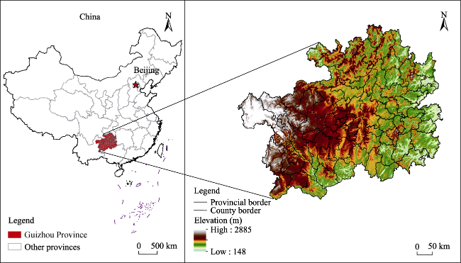
Fig. 1 Schematic diagram of the location and topography of the study area

3 Materials and methods

3.1 Data sources

This study used 88 counties (cities, districts and special zones) in Guizhou Province as the research units to develop a national spatial zoning indicator system for Guizhou Province in 2020. The required data included: 1) Socio- economic data from the China County Statistical Yearbook (2021), the Guizhou Provincial Statistical Yearbook (2021), the statistical bulletins of national economic and social development of each county and district (2020), and some missing data were collected or converted through public channels; 2) Industrial statistical data mainly from the Foresight Industry Research Institute (https://f.qianzhan.com/) and other public sources; 3) Ambient air quality index data from the environmental status bulletins of cities and states in 2020, with some data supplemented by county and city bulletins; 4) Digital inclusive finance index data from Peking University’s Digital Finance Research Center (https://idf.pku.edu.cn/index.htm); 5) Tourism statistics collected from the Department of Culture and Tourism of Guizhou Province (https://whhly.guizhou.gov.cn/) and the statistical yearbooks of each city and state (2021) and other public sources; 6) Mineral data collected from the Guizhou Mining Cloud (http://www.minecloud.com.cn/) and other public sources; 7) Ecological data collected from the China Ecosystem Assessment and Ecological Security Database (https://www.ecosystem.csdb.cn/); 8) Traffic accessibility data calculated from the data processed after vectorization of the roads in the Guizhou Provincial Traffic Map (2020); 9) Land data collected from the Resource and Environment Science and Data Center (https://www.resdc.cn/); and 10) The data of administrative divisions of counties and cities in Guizhou Province obtained from the National Basic Geographic Information Center (http://ngcc.sbsm.gov.cn/). The administrative divisions of Guizhou Province are based on the naming in 2020, but Qianxi City was renamed on March 16, 2021, so it is still called Qianxi County in this study.

3.2 Construction of the comprehensive evaluation index system of national land space

Territorial spatial function refers to the capacity and characteristics within a region that are beneficial to regional development based on its socio-economic and natural resource endowments and its industrial development, which change under the combined influences of the socio-economic base, resource endowments, and locational conditions (Ma et al., 2019; Liu et al., 2020; Liu and Zhou, 2021).
Considering the socio-economic conditions and resource endowment of Guizhou Province, and account for the availability of data, the above basic principles of the evaluation index system were followed to build the Guizhou Province Territorial Spatial Evaluation Index System from six functions of “agriculture-industry-habitat-tourism-minerals-ecology”.
The agricultural production function measures the production capacity of agricultural products in the region in terms of the production capacity of arable land. It mainly consists of eight secondary indicators, such as arable land and grain sowing area, grain and economic crop production.
The industrial development function measures the development level and scale of secondary and tertiary industries in the region in terms of the developmental capacity of those industries. It is the key indicator of the industrial development of the region, mainly consisting of six secondary indicators: the output value of the secondary and tertiary industries, the number and output value of industrial enterprises above the scale, and the grade and scale of industrial parks.
The tourism and leisure function is a comprehensive consideration of Guizhou Province's rich tourism resources and attractions as one of the important aspects of Guizhou Province’s territorial spatial function. It measures the regional tourism services and leisure indicators in terms of tourism resources and tourism carrying capacity, mainly consisting of tourism facilities and tourism resources, the number of tourists and tourism income, as four secondary indicators.
The mineral resource supply function is a comprehensive consideration of Guizhou Province’s rich mineral resources and attractions as one of the important aspects of Guizhou Province’s territorial spatial function. Considering that Guizhou Province is rich in mineral resources, which constitute an important strategic embodiment and functional subject of China and Guizhou Province, the supply capacity of regional mineral resources was measured in terms of the richness and output value of mineral resources, mainly consisting of four secondary indicators: mineral reserves and production, mineral output value and the proportion of GDP.
The ecological service function mainly considers how Guizhou Province, as a national ecological civilization test area, can realize development and protection and also achieve sustainable ecological development. It measures the ecological service level in terms of ecology, environment and resources, consisting of six secondary indicators: forest coverage, biodiversity, water conservation, rock desertification, soil conservation and erosion.
The complete spatial evaluation index system of Guizhou Province is shown in Table 1.
Table 1 Spatial functional classification and evaluation index system of Guizhou Province
Function type Code Indicator name (unit) (effect) Weight
Agricultural production function A1 Arable land area (ha) (+) 0.135
A2 Grain sown area (ha) (+) 0.130
A3 Grain production (t) (+) 0.165
A4 Economic crop yield (t) (+) 0.125
A5 Food production per capita (kg) (+) 0.135
A6 Grain yield per unit area (t ha-1 ) (+) 0.105
A7 Agricultural output value (million yuan) (+) 0.090
A8 Facility agriculture land area (ha) (+) 0.115
Industrial development function B1 Secondary and tertiary industry output value (billion yuan) (+) 0.185
B2 Secondary and tertiary industry output value to GDP ratio (%) (+) 0.165
B3 Industrial park grade and scale (dimensionless) (+) 0.205
B4 Average output value of secondary and tertiary industries on construction land (yuan ha-1 ) (+) 0.160
B5 Number of industrial enterprises above the scale (+) 0.135
B6 Total industrial output value above scale (million yuan) (+) 0.150
Human settlement services function C1 Per capita disposable income (yuan) (+) 0.165
C2 Traffic accessibility (dimensionless) (+) 0.135
C3 Per capita education expenditure (yuan) (+) 0.145
C4 Number of practicing (assistant) physicians per 1000 population (persons per 1000 population) (+) 0.140
C5 Number of beds per 1000 people (+) 0.135
C6 Ambient Air Quality Index (AQI) (dimensionless) (-) 0.125
C7 Digital Inclusive Finance Index (dimensionless) (+) 0.155
Tourism and leisure function D1 Abundance and rank of tourist sites (dimensionless) (+) 0.355
D2 Level of tourism infrastructure development (dimensionless) (+) 0.215
D3 Number of visitors received (10000 people) (+) 0.255
D4 Total tourism revenue (million yuan) (+) 0.175
Mineral resource supply function E1 Mineral production (million t) (+) 0.295
E2 Mineral reserves (million t) (+) 0.235
E3 Mineral output value (million yuan) (+) 0.255
E4 Mineral output as a share of GDP (%) (+) 0.215
Ecological service function F1 Forest cover (%) (+) 0.180
F2 Biodiversity maintenance and conservation index (dimensionless) (+) 0.164
F3 Water source connotation importance index (dimensionless) (+) 0.164
F4 Stone desertification sensitivity index (dimensionless) (-) 0.164
F5 Soil conservation importance index (dimensionless) (+) 0.164
F6 Soil erosion sensitivity index (dimensionless) (-) 0.164

3.3 Evaluation methods and steps

3.3.1 Standardization of indicators

To eliminate the influence and errors brought by such disparate data, the collected data must be processed by a standardization method before evaluation. To ensure that the data values all range from 0-1 after processing, this study adopted the standardization method of extreme difference, in which Equation (1) was used for positive indicators and Equation (2) was used for negative indicators. The formula are as follows:
y i j = x i j min x i j max x i j min x i j
y i j = max x i j x i j max x i j min x i j
In the formula, yij represents the standardized data value; xij denotes the original data value; min(xij) indicates the minimum value in the dataset; and max(xij) represents the maximum value in the dataset. The forward indicators are calculated using formula (1), while the reverse indicators are calculated using formula (2).

3.3.2 Calculation of index weights and functions

Various indicator weighting methods have been studied and improved by scholars for many years, and they can generally be divided into objective calculation methods (principal component analysis, CRITIC weighting method, entropy method, etc.) and subjective calculation methods (expert scoring method, hierarchical analysis method, multivariate analysis method, etc.). Although all scoring methods have certain advantages, there are also certain shortcomings. To combine the advantages of these two methods and reduce the influence brought by subjective calculation methods, this study selected the structural entropy weighting method combined with the two methods to determine the weights of the spatial evaluation indexes of Guizhou Province. The scoring method first adopted a combination of fuzzy analysis and the expert scoring method to obtain the “typical ranking” of each function of land space, and then reduced the “typical ranking” by the “blindness” analysis and entropy value method.
The system score of each function of the homeland space was calculated by formula (3), and counted as F. The formula is as follows:
$F=\sum_{y=1}^{n} W_{y} D_{x y}$
where F is the score of each territorial spatial function; Wy is the weight of indicator y; and Dxy is the standardized value of the y-th indicator of the x-th evaluation unit.

3.4 National spatial comprehensive planning

According to the spatial function classification and evaluation index system for Guizhou Province, the scores for various sub-functions across the 88 counties and districts were calculated. The analysis considered the spatial distribution of these scores and identified each region’s dominant functions. However, due to socio-economic complexities and resource variations, regions can excel in multiple functions, and not just a single aspect like the main functional area planning or ecological zoning. To fully capture a region’s characteristics and functions, a comprehensive territorial zoning scheme is essential. The scheme adopted here integrated the results of the single-function evaluations to comprehensively highlight each region’s strengths and dominant functions.
(1) Multi-dominant function determination. The evaluation system of the six aspects of “agriculture-industry- habitat-tourism-minerals-ecology” provided functional evaluation values for the Province’s 88 counties and districts, which can be ranked in accordance with the highest to lowest scores. The Province’s evaluation unit before the median region can then be selected, that is, the single-function score of the top 44 (out of 88) regions. At the same time, to further reflect the superiority of the dominant function, as well as to avoid higher ranking with a score that is lower and cannot be the dominant or advantageous function of the region, the function evaluation scores of the 44 regions are considered in the top sub-function ranking Fxy. They must also meet the criterion of being 1.25 times the average score of the 88 counties and districts in that sub-function. In other words, the selected unit must meet two criteria: ①Fxy greater than or equal to the median county of the evaluation unit’s sub-function score, i.e., it must be among the top 44 counties in the sub-function score; and ② Fxy F ¯ × 1.25. By the above method, all eligible functions were selected for each county and district, and the top three superior functions were selected according to the sub-functions. For counties with more than three functions, the optimal three functions were determined by ranking all sub-functions. For a district that did not meet the two conditions above, the function with the highest ranking among all its sub-functions was selected.
(2) Initially determine the comprehensive spatial classification combination of the national territory. Using the spatial clustering method of double distance, in which the selected advantageous functions are expressed and combined in a spatial distribution, the advantageous function combination can be considered consistent for the units that are directly accessible at that distance. By this method, we initially determined the comprehensive spatial classification combination of Guizhou Province.
(3) Final program determination. For the comprehensive spatial classification portfolio of Guizhou Province determined in the previous step, optimization and adjustments were made based on consultation with experts in relevant fields and regional administrators. Some units were found to be dominant for three sub-functions that were not reasonable, so they were reselected and divided according to their other sub-functions in order. At the same time, according to the actual situation for isolated units, this step allowed us to judge whether they should be retained alone or grouped around the area that can be directly reached in space. Finally, the adjusted zoning results were combined according to the principle of “same function and similar development” to obtain a homogeneous combination. They were named according to the superimposed combination of advantageous functions, which is a comprehensive functional area of the national space. The comprehensive functional zoning was divided into different sub-functional zones according to the principles of spatial proximity, the same city and state, the same level of advantages, and other considerations. The naming rule was “area + combination of advantageous functions”, forming a comprehensive zoning scheme of “comprehensive functional zone + sub-function”.

4 Results

4.1 Evaluation of the individual functions of land space in Guizhou Province

The evaluations of the six functions of 88 counties and districts in Guizhou Province were calculated by formulas (1) to (3), and the results were correlated with the administrative division data for the 88 counties and districts in Guizhou Province. The evaluation results were then classified into five levels using the equidistance method, and the spatial distributions of the six individual functions in Guizhou Province were obtained (Fig. 2).
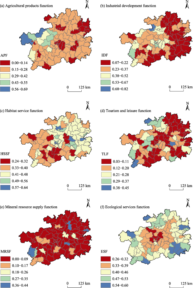
Fig. 2 Spatial distributions of the single-function evaluation results of the land space in Guizhou Province

Note: APF-Agricultural production function area; IDF-Industrial development function area; HSSF-Human settlement services function area; TLF-Tourism and leisure function area; MRSF-Mineral resource supply function area; ESF-Ecological service function area.

The counties with a strong agricultural production function (APF) in Guizhou Province are concentrated, mainly in Bijie City, Liupanshui City, Zunyi City, Anshun City and some other areas, and all eight counties and districts in Bijie City have the highest scores and the best performance in this function (Fig. 2a). The counties with a strong industrial development function (IDF) are mainly concentrated in the urban cluster of Qianzhong, the counties where the city (state) governments are located, the counties with a high level of economic development, and a high proportion of counties in Guiyang and Liupanshui, among which Nanming District, Xixiu District, and Buzhou District have the best performance in this function (Fig. 2b). The counties with a strong human settlement services function (HSSF) are mainly concentrated in Guiyang, Zunyi City, Qiandongnan Prefecture, Tongren City, and some other areas; and Guiyang City and Qiandongnan Prefecture have particularly high overall numbers (Fig. 2c). The counties with a strong tourism and leisure function (TLF) are mainly concentrated in areas with rich tourism resources and a good ecological environment, such as Liu- panshui City, Zunyi City, Qiandongnan Prefecture, Qiannan Prefecture and other counties; and the four counties in Liupanshui City have tourism and leisure as the leading function (Fig. 2d). Counties with a strong mineral resource supply function (MRSF) are mainly concentrated in Zunyi City, Bijie City and Qiandongnan Prefecture and some other areas; and half of the counties in Bijie City have higher values for this function (Fig. 2e). Counties and districts with a strong ecological service function (ESF) are mainly distributed in areas with a good ecological environment, such as Qiandongnan, Qiandongnan, Qiannan, Zunyi and some other areas, particularly five counties and districts in Qiandongnan which have rich forest resources (Fig. 2f).

4.2 Comprehensive functional zoning scheme of the land space in Guizhou Province

According to Guizhou Province’s single-function evaluation results, the 88 counties and districts can be grouped into 10 functional types and 24 sub-functional areas under a comprehensive territorial zoning scheme. This classification follows the principles of adjacent merging and accounts for various grade advantages within each functional combination. These areas were classified according to the naming rules described in the previous section to yield a comprehensive functional zoning scheme (Fig. 3) and a zoning naming table (Table 2) for Guizhou Province.
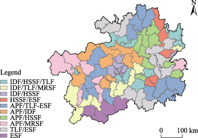
Fig. 3 Spatial distribution of the comprehensive functional zoning combinations of the land space in Guizhou Province

Note: APF-Agricultural production function area; IDF-Industrial development function area; HSSF-Human settlement services function area; TLF-Tourism and leisure function area; MRSF-Mineral resource supply function area; ESF-Ecological service function area. IDF/HSSF/TLF represents three types of integrated functional zones, indicating that the region can function as a comprehensive area dominated either by IDF, HSSF, or TLF. The meanings of the other composite legends are similar.

Table 2 Comprehensive functional zoning of the land space in Guizhou Province
Type area Sub-functional area code Sub-functional area name
Agricultural products and industrial development functional area N1 Qianzhong City cluster agricultural products and industrial development sub-functional area
N2 Xixiu-Pingba agricultural products and industrial development sub-functional area
Agricultural products and habitat
services functional area
N3 Sub-functional area for agricultural products and habitat services in three regions of northeast Qianjiang
N4 Sansui agricultural products and habitat services sub-functional area
Agricultural products and mineral
resource supply function area
N5 Puding-Zhenning agricultural products and mineral resource supply sub-functional area
N6 Tianzhu agricultural products and mineral resource supply sub-functional area
N7 Pu’an agricultural products and mineral resource supply sub-functional area
Agricultural products, tourism and
leisure and ecological services
functional area
N8 Zunyi Qianbei agricultural products, tourism and leisure and ecological services sub-functional area
N9 Sub-functional area of agricultural products, tourism and leisure and ecological services in four regions of western Qian
N10 Qiannan-Qiandongnan Southeast agricultural products, tourism and leisure and ecological services sub-functional area
Industrial development and habitat
services functional area
N11 Guiyang industrial development and habitat services sub-functional area
N12 Tongren Wuling Mountains industrial development and habitat service sub-functional area
N13 Sub-functional area for industrial development and human settlement services in the urban cluster of Qianzhong in the same city of Kaidu
Industrial development, habitat
service and tourism and leisure
functional area
N14 Zunyi Qianzhong City cluster industrial development, habitat services and tourism and leisure sub-functional area
N15 Huaxi-Longli Qianzhong City cluster industrial development, habitat services and tourism and leisure sub-functional area
Industrial development, tourism and leisure and mineral resource supply functional area N16 Liupanshui-Qianxinan industrial development, tourism and leisure and mineral resources supply sub-functional area
N17 Sub-functional area for industrial development, tourism and leisure and mineral resources supply in Qiannan-Guizhou Central City Cluster
Industrial development, tourism and leisure and ecological services
functional area
N18 Liupanshui industrial development, tourism and leisure and ecological services sub-functional area
N19 Zunyi Wumeng Mountain District industrial development, tourism and leisure and ecological services sub-functional area
Tourism, leisure and ecological
services functional area
N20 Tongren-Qiannan tourism and leisure and ecological services sub-functional area
N21 Qiannan tourism and leisure and ecological services sub-functional area
Ecological service function area N22 Yinjiang-Yanhe ecological service sub-functional area
N23 Bijie Wumeng Mountain ecological service function area sub-functional area
N24 Qianxinan-Qiannan ecological services sub-functional area
From the zoning results, the ecological service function is a single functional zoning, while all other comprehensive zoning areas are combinations of 2-3 dominant functions. This scheme indicates that seven counties in Guizhou Province (Yinjiang County, Yanhe County, Hezhang County, Weining County, Wangmu County, Chengheng County and Luodian County) are developed mainly by their ecological service function, but all the other counties are developed in multi-cluster and multi-functional ways.
From the perspective of leading functions, several patterns emerge.
(1) There are 36 counties and districts that have developed with the agricultural production service function as one of the leading functions. All these areas have 2-3 leading functions in total. While developing agricultural production, they also developed industry, habitat service, mineral resource supply service, ecological service and tourism and leisure at the same time. In the new situation with the full realization of the production service function of arable land, they also play a role in the national space.
(2) There are 42 counties and districts with industrial development function as one of the leading functions, and 15 of these counties and districts also have the human settlement service function as a leading function. This indicates that industrial development can also improve and enhance the living environment and quality of residents at the same time.
(3) There are 27 counties and districts with human settlement service function as one of the leading functions, mainly in conjunction with industrial development.
(4) There are 47 counties and districts with tourism and leisure function as one of the leading functions, indicating that there are many counties and districts in Guizhou Province that are suitable for the vigorous development of tourism industry since they have rich tourism resources. At the same time, because of the unique natural scenery and ecological environment in Guizhou, the leading areas in this category are also counties and districts with ecological service. There are 33 counties and districts in this category.
(5) There are only 13 counties and districts with mineral resource supply function as one of the leading functions, mainly in conjunction with agricultural production service function and industrial development, or the tourism and leisure function.
(6) There are 40 counties and districts with ecological service function as one of the leading functions, mainly in conjunction with other functions. There are seven counties and districts with ecological service as the single-function development, and this type of function is also mostly co- leading with tourism and leisure function.

4.3 Suggestions for adjusting the zoning of main functions in Guizhou Province

The main functional area strategy is the basic foundation and guideline for the development and protection of national land space. After the organizational reform of the Ministry of Natural Resources in 2018, main functional area zoning has become an important component of national land space planning, and it has become the main focus of the high- quality construction of China’s national land space pattern together with urban and rural planning and land use planning. In adjusting the main functional zoning of Guizhou Province, we mainly adhere to the premise of giving priority to ecological protection as well as the development and protection of the whole territorial space, while also highlighting the leading and advantageous functions of the region, and making comprehensive adjustments with reference to the results of the territorial spatial evaluation in this study and the actual situation of the county (Table 3).
Table 3 Adjustment results of the main functional area zoning in Guizhou Province
Classification type Adjusted level (pcs) Specific counties (cities, districts, special zones)
Key development
areas (41)
National level
(24)
Guiyang City (10): Nanming District, Yunyan District, Huaxi District, Wudang District, Baiyun District, Guanshan Lake District, Kaiyang County, Xifeng County, Xiuwen County, Qingzhen City
Zunyi City (4): Honghuagang District, Huichuan District, Buzhou District, Renhuai City
Anshun City (2): Xixiu District, Pingba District
Bijie City (2): Qixingguan District, Qianxi County
Qiandongnan Prefecture (2): Kaili City, Majiang County
Qiannan Prefecture (4): Duyun City, Fuchuan City, Weng’an County, Longli County
Provincial level
(17)
Liupanshui City (3): Zhongshan District, Shuicheng County, Panzhou City
Zunyi City (3): Chishui City, Xishui City, Tongzi County
Qianxinan (4): Xinyi City, Xingren City, Anlong County, Zhengfeng County
Qiannan Prefecture (3): Guiding County, Changshun County, Huishui County
Tongren City (4): Bijiang District, Wanshan District, Yuping County, Songtao County
Agricultural product
main production areas
(26)
National level
(26)
Liupanshui (1): Liuzhi Special Zone
Zunyi City (7): Suiyang County, Zheng’an County, Daozhen County, Buchuan County, Fenggang County, Meitan County, Yuqing County
Anshun City (1): Puding County
Bijie City (4): Jinsha County, Nayong County, Dafang County, Weining County
Tongren City (2): Dejiang County, Sinan County
Qianxinan (2): Zhengfeng County, Pu’an County
Qiandongnan Prefecture (8): Sansui County, Zhenyuan County, Cengong County, Tianzhu County, Liping County, Rongjiang County, Congjiang County, Danzhai County
Qiannan Prefecture (1): Dushan County
Key ecological function
areas (21)
National level
(10)
Anshun City (3): Guanling County, Zhenning County, Ziyun County
Bijie City (2): Weining County, Hezhang County
Qianyinan (2): Wangmu County, Zuheng County
Qiannan Prefecture (3): Libo County, Pingtang County, Luodian County
Provincial level
(11)
Tongren City (4): Jiangkou County, Shiqian County, Yinjiang County, Yanhe County
Qiandongnan Prefecture (6): Shiping County, Huangping County, Leshan County, Jinping County,
Jianhe County, Taijiang County
Qiannan Prefecture (1): Sandu County
Total 88
With reference to the adjustment principles and evaluation results, the main functional area zoning of Guizhou Province was ultimately adjusted to 41 key development zones, 26 main agricultural production zones and 21 key ecological functional areas, the results of which are shown in Table 3.
(1) Key development zones. Mainly in combination with the results of the spatial evaluation of land in this study, the industrial development function, human settlement service function and mineral resource supply function are the leading functions of these counties, which belong to the Qianzhong urban agglomeration as the national key development zones for adjustment, while the other counties and regions are the provincial key development zones for adjustment. They include three new national key development zones, one in Guiyang City (Kaiyang County), one in Zunyi City (Renhuai City) and one in Bijie City (Qianxi County); 11 new provincial key development zones, including one in Liupanshui City (Panzhou City), three in Zunyi City (Chishui City, Xishui City, Tongzi County); two in Qianxinan Prefecture (Anlong County, Zhengfeng County); three in Qiannan Prefecture (Guiding County, Changshun County, Huishui County); and two in Tongren City (Yuping County, Songtao County).
(2) Main production area of agricultural products. The adjusted number of counties and districts in this region is 14 less than in the previous results, and they were all adjusted to focus on the development of the region, although this adjustment does not mean that these regions are not the main embodiment of agricultural production, such as Kaiyang County, Panzhou City, Qianxi County, Songtao County, and others. Agricultural production still remains in the forefront of these counties and districts in Guizhou Province, but the adjustments to secondary and tertiary industry development are the key development direction in order to achieve a higher quality of economic development.
(3) Key ecological function area. The number of counties in this region remains unchanged from the previous results. In the evaluation results of this study, only Zhenning County, which is a key ecological function area in the main functional zoning, has the main function of producing agricultural products and supplying mineral resources. All the other counties have ecological service functions or combinations with other functions, but considering the premise that the ecological background remains unchanged or is protected and developed, we insist that it must not be adjusted and remain protected as an important ecological function area in our Province. In addition, since Libo County has become a national key ecological function area by policy in 2011, and received the central financial transfer payments, it was finally adjusted to be a national key ecological function area.
Of course, under the premise of the “three spaces” and the comprehensive use of land and space, the counties and districts classified here are only divided by their most prominent functions, although the other functions should not be ignored. At the same time, main functional zoning is only one of the components of territorial spatial planning, and the development of a county needs to be combined with the latest developments in “three zones and three lines”, land use planning, urban development and other results for a more detailed planning strategy for the whole area.

4.4 Policy suggestions for synergistic development of the different main functional regions in Guizhou Province

Emphasizing county spatial zoning, this study underscores coordinated regional development for ensuring a balanced and sustainable growth model across diverse functions. Based on the results, we make the following recommendations.
(1) Coordinate and promote the preparation and implementation of territorial spatial planning. While adhering to the requirement of “whole-area planning and comprehensive planning”, we should carry out comprehensive planning of the regional space.
(2) Optimize the spatial layout and reasonable allocation of construction land. Taking the integration of multiple regulations as the guide, with the goals of optimizing the spatial structure, improving urban facilities, strengthening comprehensive service functions and enhancing urban development quality, and according to the principle of “central concentration, group expansion and regional coordination”, the regional population and capacity for attracting industry will be improved and the industrial structure and spatial layout will be optimized.
(3) Guizhou Province should actively integrate into national strategies like “One Belt, One Road” and “Western Development”, thereby aligning with state, provincial, and municipal development plans. We should implement regional coordination strategies and initiatives, including the “Five-Year Plan for a Stronger Provincial Capital”, the “Li-Cong-Rong”(“Li-Cong-Rong” stands for Liping County, Congjiang County and Rongjiang County.) project linking the Guangdong-Hong Kong-Macao-Great Bay Area, and the “Fourteen-Year Plan for Guizhou’s Development”, and respond to the State Council’s support for western development in the new era.
(4) Adopt innovative regional cooperation and mutual assistance mechanisms. Taking the Qianzhong City cluster, city circle and town cluster as opportunities, we should encourage the mechanism of deep integration between regions in combination with their main functions and advantages, carry out inter-regional cooperation in multiple fields and ways, and promote cooperation mechanisms such as the regional transfer of industries to achieve regional transfer and park co-construction.
(5) Improve the development mechanism of market integration. We should give full play to the role of the market mechanism, remove all policy and mechanism obstacles that restrict development, at both early and pilot stages, and actively innovate to create market integration development mechanisms, such as accelerating the free flow of factors between urban and rural areas, promoting the integration of regional market construction and improving regional trading platforms and systems.

5 Discussion

Territorial spatial zoning is a complex, multifaceted and systematic project, which is influenced by natural, humanistic, socio-economic and other conditions. Based on the interpretation of the existing territorial spatial classification system, this study is oriented from the perspectives of “how to construct the zoning index of county territorial spatial units in Guizhou Province” to “how to reflect and integrate the territorial spatial functions” and “the comprehensive and coordinated development of territorial space”. The project is oriented to the problems of “comprehensive and coordinated development”. Taking Guizhou Province, a national ecological civilization pilot area, as the research object, we constructed an index system for the evaluation of Guizhou Province’s land space from six functions: agriculture-industry-habitat-tourism-minerals-ecology, and analyzed the single-function evaluation and spatial distribution results of the 88 counties and districts in Guizhou Province. Based on the evaluation results and the spatial distribution of individual functions in 88 counties and districts in Guizhou Province, we compared the evaluation results and the main functional zoning, and developed the comprehensive functional zoning scheme, as well as the development mode and strategy of the comprehensive functional zoning. Using the three steps of multi-dominant function determination, preliminary determination of the combined integrated territorial spatial classification and final scheme determination, the 88 counties and districts in Guizhou Province were divided into 10 functional types and 24 sub-functional areas to generate an integrated territorial spatial functional zoning scheme. By comparing and verifying the results of the spatial function classification with the main functional zoning, the functions of almost all areas were consistent, except for some counties and districts which needed to be adjusted to industrial development functional zones due to their industrial and economic development situations. This consistency indicates that the spatial zoning results of Guizhou Province adopted in this study are credible, and the spatial evaluation index system of Guizhou Province constructed in this study can be used for screening the dominant functions of different counties and districts in Guizhou Province. The spatial evaluation index system of Guizhou Province can provide a scientific basis and guidance for the rational layout and coordinated development of the different main functional zones and the enhancement of county economies and competitiveness under the premise of identifying the dominant functions of the different counties.

6 Conclusions

This study systematically organized the research findings and aligned them with Guizhou Province’s realities to propose a county territorial spatial unit zoning framework. It established an index system, outlined operational methods, and devised a zoning index scheme for Guizhou's 88 counties and districts. Considering the socio-economic conditions and resource distribution, it constructed an evaluation system based on agriculture, industry, habitat, tourism, minerals, and ecology.
(1) There are large variations in the evaluation of the individual functions of land space in Guizhou Province.
In terms of quantity, the categories of industrial development function (30.68%) and tourism and leisure function (30.68%) are the most numerous single-function types, with each occurring in 27 counties and districts. Next in descending order are the agricultural production function (28.41%), mineral resource supply function (26.14%), habitat service function (23.86%), and ecological service function (22.73%).
(2) There are some differences between the results of the single-function evaluation and the results of the main function zoning.
In the comparison between the main agricultural production areas and the results of single-function evaluation of land space in this study, the number of consistent units was 31. The number of units in the single-function evaluation of land space was nine less than the number of main agricultural production areas, 10 of which were adjusted to key development zones (Kaiyang County, Renhuai City, Chishui City, Qianxi County, Guiding County, Dushan County, Changshun County, Panzhou City, Anlong County, Yuping County), and the key ecological function zones are adjusted from Weining County is the largest county in Guizhou Province, with a land area of 6298 km² and a residential population of 1.28 million in the seventh census, so it is a relatively large area with a large population.
From the perspective of leading functions, three main patterns emerged. 1) There are 37 counties and districts that have developed with agricultural production service function as one of the leading functions, and each of these areas has 2-3 leading functions. While developing agricultural production, they also developed industry, habitat service, mineral resource supply service, ecological service, tourism and leisure in the full realization of their production service function of arable land, and at the same time they represent a national space. 2) There are 42 counties and districts with industrial development function as one of the leading functions, and 15 of them also had the human settlement service function as a leading function, indicating that industrial development can also improve and enhance the living environment and quality of residents at the same time. 3) There are 27 counties that prioritize human settlement services alongside industrial development. Additionally, 47 counties focus on tourism and leisure, benefiting from their abundant tourism resources. Counties emphasizing ecological services, owing to their unique natural scenery, total 33. Mineral resource supply is a leading function in only 13 counties, often paired with agricultural and industrial roles. Ecological service is a primary function in 40 counties, often in conjunction with others, while seven counties specialize in single-function ecological service development, frequently alongside tourism and leisure activities.
[1]
Buitelaar E, Sorel N. 2010. Between the rule of law and the quest for control: Legal certainty in the Dutch planning system. Land Use Policy, 27(3): 983-989.

[2]
Li P X, Zhou J, Liu S W. 2021a. Assessment and integration of natural elements in national spatial planning: Progress and prospects. Ecology and Environmental Sciences, 30(12): 2431-2440. (in Chinese)

[3]
Li Z Y, Li Y Y, Wang L, et al. 2021b. Study on the functional characteristics and division optimization of “Production-Living-Ecological” of geographical space in Yunnan Province. Ecological Economy, 37(6): 94-101. (in Chinese)

[4]
Lin J Y, Li X. 2014. The division of main functional areas in Dongguan based on spatial autocorrelation. Geographical Research, 33(2): 349-357. (in Chinese)

[5]
Liu C F, Li P J, Liu L C, et al. 2020. Ecological restoration zoning of provincial land space in northwest ecologically fragile area. Transactions of the Chinese Society of Agricultural Engineering, 36(17): 254-263. (in Chinese)

[6]
Liu Q Q, Zhao H F, Wu K, et al. 2014. A study on potential land use conflict identification based on land use competitiveness—A case study of Daxing District, Beijing. Resource Science, 36(8): 1579-1589. (in Chinese)

[7]
Liu Y H, Zheng D, Ge Q S, et al. 2005. Awareness of some issues on conducting comprehensive zoning studies in China. Geographical Research, 24(3): 321-329. (in Chinese)

[8]
Liu Y S, Liu Y, Chen Y F. 2011. Evaluation of regional multifunctionality in China and its decision-making mechanism. Acta Geographica Sinica, 66(10): 1379-1389. (in Chinese)

[9]
Liu Y S, Zhou Y. 2021. Territory spatial planning and national governance system in China. Land Use Policy, 102: 105288. DOI: 10.1016/j.landusepol.2021.105288.

[10]
Ma J S, Li X, Zhu L, et al. 2019. Comparative study of multi-perspective approaches to county-level spatial development suitability assessment methods. Chinese Journal of Agricultural Resources and Regional Planning, 40(11): 193-199. (in Chinese)

[11]
Neil B. 1997. State territorial restructuring and the production of spatial scale: Urban and regional planning in the Federal Republic of Germany, 1960-1990. Political Geography, 16(4): 273-306.

[12]
Nian P H, Cai Y M, Xie X Z, et al. 2014. Comprehensive functional zoning of Hunan Province’s land space based on ecological niche theory. Resource Science, 36(9): 1958-1968. (in Chinese)

[13]
Rodenburg C A, Nijkamp P. 2007. Multifunctional land use. Berlin, Germany: Springer.

[14]
Steiner F, Mcsherry L, Cohen J. 2000. Land suitability analysis for the upper Gila River watershed. Landscape & Urban Planning, 50(4): 199-214.

[15]
Sun C Z, Li P, Deng Y, et al. 2022. Ecological construction zoning of beautiful China based on spatial heterogeneity of ecosystems. Acta Geographica Sinica, 77(11): 2902-2919. (in Chinese)

[16]
Verburg P H, Overmars K P. 2009. Combining top-down and bottom-up dynamics in land use modeling: Exploring the future of abandoned farmlands in Europe with the Dyna-CLUE model. Landscape Ecology, 24(9): 1167. DOI: 10.1007/s10980-009-9355-7.

[17]
Wang Z J, Huang Y P, Xie L R. 2022. Exploration of county-level territorial spatial planning zoning methods—Huangmei County, Hubei Province as an example. Journal of Natural Resources, 37(11): 2837-2855. (in Chinese)

[18]
Xie G D, Cao S Y, Leng Y F, et al. 2012. Functional zoning of sustainable development in China. Resource Science, 34(9): 1600-1610. (in Chinese)

[19]
Xu Y, Guo N, Ru K L, et al. 2022. Spatial zoning characteristics and optimization strategies of Fujian Province from the perspective of carbon neutrality. Chinese Journal of Applied Ecology, 33(2): 500-508. (in Chinese)

Outlines

/