Disaster Prevention and Pollution Control

Toughness Evaluation and Functional Enhancement of Disaster Prevention and Avoidance of Urban Park Green Space

  • WEN Yu , 1, * ,
  • ZHANG Yiyuan 1 ,
  • ZHANG Xinjia 1 ,
  • LONG Tao 2
Expand
  • 1. School of Arts and Design, Yanshan University, Qinhuangdao, Hebei 066000, China
  • 2. Qinhuangdao Architectural Design Institute Limited, Qinhuangdao, Hebei 066000, China
* WEN Yu, E-mail:

Received date: 2023-05-30

  Accepted date: 2023-11-30

  Online published: 2024-12-09

Supported by

The Project of Hebei Social Science Foundation(HB23YS015)

Abstract

Urban park green space effects a critical role in addressing adverse climate and uncertain disaster events. Thus, it is exceedingly significant for evaluating and analyzing the disaster prevention and resilience ability of urban parks and for enhancing their disaster prevention function. Using ArcGIS software, the study analyzed the kernel density pertaining to the spatial distribution of park green space in Haigang District, Qinhuangdao City. The results indicated that there is a spatial mismatch between park green space resources and population distribution in Haigang District. If Tanghe Park is considered as the research object, the Fuzzy Delphi method and analytic hierarchy process are utilized to construct an evaluation index system, and 13 indexes from three dimensions, namely safety, accessibility, and infrastructure were evaluated to analyze the problems pertaining to the disaster-prevention resilience design of the park. Subsequently, the following corresponding strategies are proposed: optimizing the human-oriented spatial layout and building a nested disaster prevention network system; strengthening the park’s multi-disaster comprehensive defense capability and stabilizing the ecological security function; increasing the safe and effective escape area and enhancing the park’s functional space layout; and replenishing emergency infrastructure resources and establishing dynamic emergency management plans.

Cite this article

WEN Yu , ZHANG Yiyuan , ZHANG Xinjia , LONG Tao . Toughness Evaluation and Functional Enhancement of Disaster Prevention and Avoidance of Urban Park Green Space[J]. Journal of Resources and Ecology, 2024 , 15(6) : 1502 -1517 . DOI: 10.5814/j.issn.1674-764x.2024.06.009

1 Introduction

The United Nations Intergovernmental Panel on Climate Change (IPCC) notes that under global warming, the frequency and severity of adverse weather events such as drought, fire, storm, flood, and heat wave are increasing (Fan et al., 2021). The sustainable development of cities is crucially threatened by climate change (Chen et al., 2021), which may occasion disastrous effects. Frequent and exceedingly severe natural disasters have occurred in the country, with a large variety, high frequency, broad region, and heavy loss. Therefore, the urban disaster prevention and reduction system is subjected to severe challenges; thus, academia are dedicating increased research attention to the construction of resilient cities.
“Resilience” implies a “return to the original state”. The term “resilient city” indicates that the urban system possesses the ability to reduce the impact of disasters or emergencies and adapt to them, or the ability to recover quickly when it is damaged by external shocks or damage (Bing et al., 2017). To cope with the impact of environmental factors such as global climate change and natural disasters, China has clearly proposed the construction and development of “resilient cities” in the 14th Five-Year Plan and the outline of the Vision Goal 2035, and many cities such as Beijing, Shanghai, Chengdu, and Xi’an have incorporated “resilient cities” into their urban master plans.
The park green space is a crucial ecological space of the city and an open space that can provide a safe refuge and basic living security for urban residents when disasters occur, which is conducive to enhancing the city’s resilience. The literature analysis indicated that contemporary studies mainly focus on the analysis and evaluation from the population accessibility (Ji et al., 2019), land suitability (Pokhrel, 2019), and service scope (Zhang et al., 2012) of park green space, and the evaluation objects are mostly focused on the park green space in big cities or megacities (Fei et al., 2020); the disaster prevention resilience of parks in small and medium-sized cities is rarely analyzed, and the quantitative evaluation of the park lacks data analysis. The GIS evaluation method is mainly utilized to analyze park green space in large mesoscale regions such as provinces, cities, and districts (Şenik and Uzun, 2021; Alawi et al., 2023), whereas single small-scale parks are rarely analyzed. Consequently, in regard to enhancing the disaster prevention function of parks, a detailed design cannot be formulated owing to a lack of data support. Herein, Qinhuangdao is utilized as an example: based on the spatial distribution relationship between park green space resources and population distribution, if Tanghe Park is considered as a case study, the fuzzy Delphi method and analytic hierarchy process were utilized to construct an evaluation index system. ArcGIS technology and field research were utilized to analyze and evaluate various indicators, and the direction of enhancing the park’s disaster prevention resilience was defined. Thus, a scientific basis for optimizing and enhancing the design pertaining to the disaster prevention resilience of park green space is offered.

2 Research status

2.1 Foreign research status

Web of search as (“Park*” OR “Parkland”) AND (“Disaster Prevention” OR “Disaster Preparedness” OR “Preventing Disaster”) subject retrieval was conducted in the core collection database of Science, and visualization analysis was performed using the Cite Space software. The timeline map of key words in Fig. 1 indicates that physical activity, green infrastructure, risk assessment, urban planning, and professional are the top 5 high-frequency keywords. It can be observed that foreign studies in this field focus more on the following three directions: disaster prevention and avoidance park green space and residents’ health and well-being, risk assessment, and landscape design. Moreover, studies on public health issues and single-factor natural disasters are considerably concentrated, mostly focusing on single disasters such as infectious diseases (Kawlra and Sakamoto, 2023), heat wave (Brown et al., 2015; Wong et al., 2021), earthquake (Villagra et al., 2014; Anhorn and Khazai, 2015), and flood (Carter et al., 2018). From 2019 onwards, the key words that exhibit high emergence are “Green Infrastructure”, “Sustainable Development”, “Urban”, “Challenge”, and “Framework”, which indicates that the sustainable development-based construction of green infrastructure as a method of enhancing the city’s ability to cope with disaster challenges is one of the main research topics.
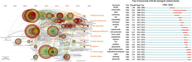
Fig. 1 Timeline map and high emergence keyword map of international research, 1984-2022

2.2 Domestic research status

A topic search was conducted on China National Knowledge Network (CNKI) using “Park” AND “Disaster Prevention” as the search methods. The keyword timeline map depicted in Fig. 2 indicates that the first literature in this research field appeared in 1996, which may be related to the effective role of urban parks in disaster prevention during the Great Hanshin Earthquake (1995) in Japan. After the Wenchuan earthquake (2008), the research direction gradually shifted to exploring the planning, design, and construction of urban disaster prevention and avoidance park green space, and researchers evaluated the accessibility (Ji et al., 2019), layout rationality (Liang et al., 2010; Zhu et al., 2010), safety (Ma et al., 2005; Zhu and Su, 2013), and suitability (Ye et al., 2010) of park green space (Chen et al., 2019). According to the keyword timeline map depicted in Fig. 2, the keyword “resilience” appeared in #1 urban park cluster during the 2019-2022 period, indicating that more scholars began to consider the analysis pertaining to the resilience of urban parks. Since 2019, the high-emergence key words are “Space Syntax”, “Urban Park”, and “Plain- calamity combination”, indicating that the disaster prevention design of urban parks based on a plain-calamity combination is a popular research topic in contemporary research (Mu et al., 2020), and that space syntax is often applied in designing the park spatial layout (Zhang et al., 2019).
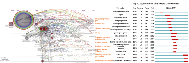
Fig. 2 Timeline map and high emergence keyword map of China, 1996-2022

3 Spatial distribution of park green space in Haigang District, Qinhuangdao City

Qinhuangdao is located on the coast of Bohai Sea, which is vulnerable to the combined flood disaster occasioned by immense rainfall and high storm surge (Xu et al., 2022). In addition, some scholars predicted that the probability of moderate and strong earthquakes in Qinhuangdao is expected to be higher based on the seismic activity characteristics and the historical seismic activity and local structural characteristics of Qinhuangdao (Zhao et al., 2016). Therefore, it is particularly crucial to enhance the disaster prevention and avoidance function of Qinhuangdao park green space. Located in the east of Qinhuangdao City, Haport District is the main urban area of Qinhuangdao and the largest central urban area of Hebei Province. It covers an area of 701 km². According to the 7th census conducted in 2020, the port district exhibits a permanent population of 1024876; thus, it the most densely populated urban area in Qinhuangdao. The seismic fortification intensity of urban areas is 7 degrees. Small cities, medium-sized cities, and large Type II cities with a ≤7 degree seismic fortification intensity in the Guidelines for Disaster Prevention and Risk Prevention Design of Urban Green Spaces should be configured according to the following three levels: medium term sheltered green space-short term sheltered green space-emergency sheltered green space.

3.1 Basic information of park green space

A complete design code represents a guide for the planning and construction of disaster prevention and risk aversion parks; however, there is no unified standard for the construction of both disaster prevention and risk aversion parks. Based on the research conducted by Ji et al. (2019) and Fei and Gao (2020), we can comprehend current standards and guidelines such as “Emergency shelter for earthquake disasters - Site and its facilities” (GB21734-2008), “Code for design of disasters mitigation emergency congregate shelter” (GB5143-2015), “Code for the design of public park” (GB51192-2016), “Standard for classification of urban green space” (CJJT85-2017), and “Guidelines for Design of Urban Green Space Disaster Prevention and Refuge” (2018); moreover, the construction standard of disaster prevention and avoidance park green space (Table 1) is addressed, and on this basis, the park green space in Qinhuangdao is classified and evaluated.
Table 1 Standard for the construction of green space for disaster prevention and avoidance parks
Type of park Classification of safe-haven green spaces Area (ha) Effective evacuation area per capita (m2 person-1) Service radius (m) Disaster prevention facilities
Comprehensive park Long term sheltered green space ≥50 ≥5 ≤2500 Basic facilities; General facilities; Comprehensive facilities
Medium term sheltered green space ≥20 ≥2 ≤1500 Basic facilities; General facilities
Short term sheltered green space ≥5 ≥2 ≤1500 Basic facilities; General facilities
Community park Emergency sheltered green space ≥0.2 ≥1 ≤500 Basic facilities
Specialized parks Zoo: Not suitable - - - -
Botanical garden: Short term sheltered green space ≥1 ≥2 ≤1500 Basic facilities; General facilities
Historic garden: Not suitable - - - -
Heritage park: Not suitable - - - -
Amusement park: Not suitable - - - -
Garden Emergency sheltered green space ≥0.2 ≥1 ≤500 Basic facilities

Note: Basic facilities (Emergency tent facilities; Medical care and epidemic prevention facilities; Emergency water supply facilities; Emergency power supply and lighting facilities; Emergency communication facilities; Emergency sewage facilities; Emergency toilets; Emergency waste storage and transportation facilities; Emergency passage; Emergency signs, Distribution site); General facilities (Emergency firefighting facilities; Emergency supply reserve facilities; Emergency command management facilities);Comprehensive facilities (Emergency parking; Emergency apron; Emergency bath facilities; Emergency function introduction facilities).

According to the type and area scale of green space construction standards for disaster prevention and avoidance parks categorized in Table 1, 18 park green spaces in the harbor area were classified, among which 2 were medium term sheltered green space, 8 were short term sheltered green space, and 8 were emergency sheltered green space. Based on the combination of field investigation and park satellite image, the evacuable population of each park can be estimated by deducting the water area, buildings, and collapsed area of buildings (Fig. 3).
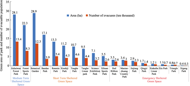
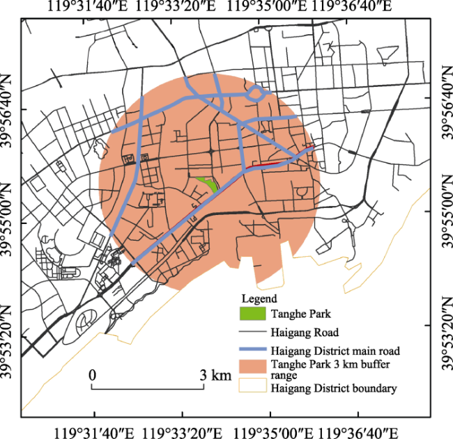
Fig. 3 Green area of park and number of evacuable population in Haigang District

3.2 Park green space distribution

The balance between park green space layout and resident population distribution is a crucial indicator for measuring the service function of park green space, as well as a critical basis for evaluating the quality of the urban residential environment (Xing et al., 2020). The population kernel density map of the harbor area (Fig. 4) indicates that the kernel density value represented by the red area in the figure is the highest, which mainly gathers in the southwest and gradu- ally diffuses to the east, with the population gathering in a class “one” zonal pattern. The location information of Hai-gang District park is obtained by Baidu Map POI, and the road network data of Haigang District, Qinhuangdao is obtained from OpenStreetMap (OSM). Based on ArcGIS software, the transportation network is established through the urban road network data. According to the park classification and service radius standard depicted in Table 1, the service coverage capability of 18 parks in the Haigang District is analyzed with a 500, 1000, and 1500 m radius, respectively (Fig. 5). The results indicate that the green space of the park in Haigang District is relatively concentrated in the southern area, and that the spatial distribution pattern is scattered, and the overall distribution is non-uniform.
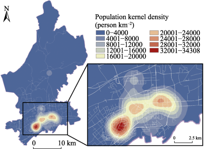
Fig. 4 Population kernel density
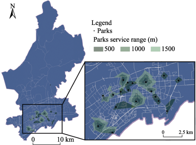
Fig. 5 Park service coverage
The population kernel density map is superposed with the park service coverage map to obtain the spatial distribution diagram of the park service-covered population in the study area (Fig. 6). Figure 6 indicates that there are service blind areas of different degrees in areas with high-population kernel density. The southwest and southeast are densely populated; however, few parks are distributed, and there are large blind areas, which directly leads to the decline of disaster avoidance space service efficiency and disaster avoidance ability. In the most populated area in the southwest, there is only one Jinjiang community park with an area of 2.9 ha. However, if it is utilized as an emergency sheltered green space, its internal basic disaster prevention facilities can meet only the short-term shelter needs of 23000 individuals for one to three days, and it is difficult to accommodate more individuals and longer service needs. As a nearby short term sheltered green space, Tanghe Park can accommodate more residents in the event of disaster.
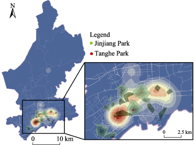
Fig. 6 Overlay of population kernel density and park service coverage

4 Qinhuangdao Tanghe Park disaster prevention evaluation

4.1 Index selection

Optimizing and enhancing the disaster prevention resilience design of Tanghe Park can crucially promote the development of urban resilience. By combing and referring to the domestic and foreign literature on the relevant index system of emergency shelters and urban green space, as well as to the standard specifications such as “Earthquake Emergency Shelter Sites and Supporting Facilities”and “Urban Green Space Disaster Prevention and Risk Avoidance Design Guidelines”, the indicators are screened according to the principles of objectivity, scientificity, and operability; subsequently, the Fuzzy Delphi method is utilized to construct an evaluation system containing 13 secondary indicators from the three dimensions, namely safety, accessibility, and infrastructure (Table 2). Safety is the primary feature of shelters (Wang et al., 2014). Secure emergency shelters can ensure the safety of residents' lives and property. Accessibility is the basic demand of residents who exhibit the need for parks, and traffic accessibility effects a major role in realizing the service function of shelters (Lu et al., 2022); the enhancement of infrastructure and support capacity is not only the basic guarantee for the resettlement of victims, but also the main factor affecting the disaster prevention function of park green space (Xu and Zhang, 2020).
Table 2 Evaluation index system of disaster prevention resilience in Tanghe Park
First level A Weight Second level B Weight Evaluation criterion Comprehensive weights Index
reference
Safe 0.5499 Geological
conditions
0.1733 A. There is a development fault Neither A nor B is present-10 points 0.0953 Zhu and Su (2013); Ji et al.
(2021); Şenik and Uzun (2021);
Alawi et al. (2023)
B. Disaster prone areas In A and B, 1 item-5 points
C. In the flooding danger area such as tsunami A, B, and C possess more than 2 items-0 points
Topography and landforms 0.2751 A. The terrain is higher A. To assign 1-5 points according to the terrain height 0.1513
B. Slope B. 5 points for less than 15°; 0 points for more than 15°
Plant isolation 0.1092 Plant species selection and
collocation
To assign 1-10 points according to the fire prevention effectiveness 0.0600
Refuge area 0.1375 A. Service scope of the public asylum needs A. 10 points 0.0756
B. The service scope does not meet the citizen’s asylum needs B. 5 points
Hazard source 0.2183 A. Range of impact of the
building collapse
A. 1-4 points according to influence range (larger score; lower score) 0.1200
B. Close to the gas station B. 3 points for >100 m; 0 for 0-100 m
C. Close to the flood risk zone C. 3 points for > 100 m; 0 for 0-100 m
Security
environment
0.0866 A. Security system A. To assign 1-3 points according to the perfection degree 0.0476
B. Emergency plan B. To assign 1-4 points according to the perfection degree
C. Manager C. To assign 1-3 points according to the perfection degree
Accessibility 0.2098 Space accessible 0.6667 A. Entrances and exits A. To assign 1-3 points according to the perfection degree 0.1399 Ma et al. (2022); Alawi et al. (2023); Lv et al. (2023)
B. The evacuation route in the park B. To assign 1-3 points according to the perfection degree
C. Distance from the main road C. 4 points less than 500 m; 2 points for 500-1500 m; 0 points greater than 1500 m
Rescue
accessible
0.3333 A. Distance to the fire station A. 5 points for 0-1 km; 3 points for 1-3 km; 0 points for greater than 3 km 0.0699
B. Distance to the hospital B. 5 points for 0-1 km; 3 points for 1-3 km; 0 points for greater than 3 km
Infrastructure 0.2402 Living facilities 0.4171 A. Power supply facilities A. To assign 0-2 points according to the perfection degree 0.1002 Zhu and Su (2013); Wu et al. (2015); Ji et al. (2021)
B. Water supply facilities B. To assign 0-2 points according to the perfection degree
C. Shump facilities C. To assign 0-2 points according to the perfection degree
D. Toilet D. To assign 0-2 points according to the perfection degree
E. Blowdown E. To assign 0-2 points according to the perfection degree
Medical
facilities
0.2242 Medical relief station To assign 1-5 points according to the perfection degree 0.0539
Command
facilities
0.1185 A. Emergency command center A. To assign 1-5 points according to the perfection degree 0.0285
B. Broadcasting station B. To assign 1-5 points according to the perfection degree
Publicity
facilities
0.0838 A. Disaster prevention
identification system
A. To assign 1-5 points according to the perfection degree 0.0201
B. Billboards B. To assign 1-5 points according to the perfection degree
Firefighting facilities 0.1564 A. Fire equipment A. To assign 1-5 points according to the perfection degree 0.0376
B. Fire passage B. To assign 1-5 points according to the perfection degree
Compared with the traditional Delphi method, the fuzzy Delphi method can effectively reduce the number of surveys and the number of participating experts, and can scientifically and objectively obtain the consensus of expert opinions. Therefore, the analytic hierarchy process is utilized to determine the index weight. In the scoring process, experts with professional backgrounds in fields such as landscape architecture and urban planning are invited to provide weight scores. ArcGIS technology and the field investigation method are utilized to analyze each index, and the five-level Likert scale is applied for grading, where very good (8.5-10.0 points), good (7.0-8.4 points), average (5.5 -6.9 points), poor (3.0-5.4 points), and very poor (0-2.9 points) represent the scores.

4.1.1 Security

When utilizing a refuge after a disaster event, safety principles must be observed to prevent secondary hazards to residents and ensure safety in the space (Wang, 2019). Zhu and Su (2013) utilized geological conditions, landforms, and plant isolation indicators to evaluate the safety of disaster prevention parks. Alawi et al. (2023) classified the proximity to flood water sources, gas stations, building collapse hazards, and management indicators as safety dimension indicators, thereby evaluating the earthquake resilience of public open spaces such as squares and parks. Şenik and Uzun (2021), also observed that these indicators are crucial for evaluating refuge sites.
(1) Geological Conditions. According to China’s “Earthquake Emergency Shelter Site and Supporting Facilities” standards, the geological conditions of parks and other shelters should avoid earthquake fault zones, flood, landslide, debris flow, and other areas prone to natural disasters and earthquake secondary disaster sources.
(2) Topography and landforms. Terrain is a leading factor for inducing geological disasters. Terrain with a slope greater than 20% (7.2°) is prone to varying degrees of landslides, collapses, and secondary disasters (Chen et al., 2016), while areas with a slope greater than 15% (8.53°) are not suitable for disaster prevention (General Office of the Ministry of Housing and Urban-Rural Development of the Individuals’s Republic of China, 2018).
(3) Plant Isolation. Plants with high moisture content and low oil content can more effectively block the spread of fire occasioned by earthquakes and other disasters, and the branches and leaves of trees can block heat radiation and alleviate the spread of fire (Wang and Zhang, 2014).
(4) Refuge Area. Appropriate per capita effective refuge area can provide favorable living conditions for asylum seekers and facilitate safe evacuation and management, especially when evacuating secondary disasters (Chu et al., 2013).
(5) Hazard Source. Emergency shelters close to dangerous sources can lead to secondary disasters. When an earthquake occurs, buildings are prone to damage and collapse, and building collapse and falling objects are the main factors affecting evacuation and refuge (Cai, 2018), and also the causative factor for many casualties in the case of large earthquakes (Song et al., 2019). Meanwhile, evacuation centers should be situated far away from flood danger areas and gas stations to prevent fire risks (Şenik and Uzun, 2021).
(6) Security Environment. The increase in the frequency of natural disasters can exert a negative impact on the safe operation of parks. Therefore, satisfactory public security work in parks and appropriate management methods are strong guarantees for park management (Li et al., 2018).

4.1.2 Accessibility

The evaluation of space accessibility includes two components: refuge accessibility and rescue accessibility. Refuge accessibility refers to the convenience with which individuals can reach the refuge place within a safe time limit after the disaster, whereas rescue accessibility refers to the ease of contact between emergency shelter and rescue facilities (Cui et al., 2022). Ma et al. (2022), Lv et al. (2023), and Alawi et al. (2023) evaluated the service status of park green space in disaster prevention based on accessibility indicators such as distance from main roads, distance from fire stations, and distance from medical institutions.
(1) Space accessible. The urban road is the preferred escape path, but also a crucial channel for fire, emergency, and disaster relief. The park’s entrance and exit should be connected with the urban road; the number of entrances and exits is large, and the more open the space, the more residents will be able to quickly transfer to the park for refuge during the disaster. Due to the optimally-planned and rational space road system in the park, individuals can conduct daily visits and can be easily evacuated in case of emergencies.
(2) Rescue accessible. The distance between the fire station and the location of the fire directly influences the disaster relief outcome. The higher the accessibility of the fire station, the higher the fire protection benefit. Hospital accessibility is also directly related to the opportunity and efficiency with which residents can receive medical services. Therefore, by considering the distances to fire stations and hospitals, the park’s disaster resistance was evaluated.

4.1.3 Infrastructure

Zhu et al. (2010), Wu et al. (2015), and Ji et al. (2021) have built infrastructure evaluation indicators covering five aspects: life, medical care, command, publicity, and fire protection. Thus, they evaluate the disaster reduction capacity of emergency shelters.
(1) Living facilities. The living facilities of the disaster prevention park mainly include domestic water, electricity, emergency toilets, and tent accommodation facilities to ensure the basic living needs of personnel.
(2) Medical facilities. The availability of basic medical facilities and medicines, as well as proximity to medical services, is a crucial factor for assessing the suitability of a shelter (Anhorn and Khazai, 2015), enabling the timely treatment of injured or sick individuals and reducing the risk of deterioration and death.
(3) Command facilities. When a disaster occurs, the emergency command center allocates resources, transmits information, and provides medical assistance and other emergency commands, thus providing an effective guarantee for the safety management of the park and realizing effective emergency response (Ning and Yao, 2021).
(4) Publicity facilities. Through the display of publicity facilities, the public can be familiarized with the information pertaining to the park, understand self-rescue skills and how to utilize emergency equipment, and other information, which can enhance the public’s awareness of disaster prevention and self-rescue ability (Tang et al., 2020).
(5) Firefighting facilities. In the event of a fire, to reduce its impact on the park and the surrounding environment, a certain number of emergency firefighting facilities should be equipped, and the surrounding fire station resources should be comprehensively utilized (Ji et al., 2021).

4.2 Results and analysis

4.2.1 Security

4.2.1.1 Geological conditions

Chen et al. (2020) extracted the distribution of geological disaster points in regions where geological disasters had occurred to measure the degree of vulnerability to geological disasters, and found that there was a significant correlation between the degree of vulnerability to geological disasters and the number of disaster points. Therefore, fault zone data, geological disaster point data since 1990, and ASTER GDEM 30 m resolution digital elevation data of Haigang District were obtained from National Data Sharing Center for Seismic Science, Resources and Environmental Science and Data Center of Chinese Academy of Sciences and geospatial data cloud platform. After ArcGIS projection, the seismic fault zone, geological disaster, and crucial variable elevation in the study area were analyzed. Figure 7 indicates that the topography of the Haigang District is high in the north and low in the south, and that it gradually decreases from the mountainous area to shallow sea. Geological disaster points gather in the northern mountainous area, which is the area with high-incidence geological disasters, whereas the southern area is the area with low-incidence geological disasters. Tanghe Park is located in the southern zone of the city, avoiding the Luanxian-Letting earthquake fault zone, far away from the high-incidence geological disasters, and the surrounding terrain is flat.
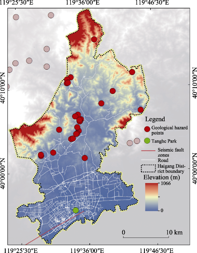
Fig. 7 Geological disaster ponits of Haigang District

4.2.1.2 Topography and landforms

In the ArcGIS software, the high-resolution remote sensing image is combined with the spatial contour of Tanghe Park obtained by Autonavi AOI data for vectorization processing, and the TIN surface is created with the elevation point as the input variable. According to the TIN surface, the digital elevation model (DEM) with 1 m resolution is generated. Figure 8 idncites that the highest point of elevation within the site is located at the eastern and southern edges of the park, among which the highest point is approximately 8.656 m, and the lowest point is approximately 2.326 m at the western edge of the park, with a 6.33 m height difference. The elevation of most areas in the park is 3.592-4.088 m, and the overall topography is not quite undulating. The elevations of municipal roads in the north and east of the park are 3.592-4.088 m and 2.326-3.592 m, respectively, which are lower than the elevation of the park. The elevation of the road on the south side is similar to the park’s boundary, and gradually decreases to the inside of the park, which enables the road’s surface runoff to import into the park and into the Tang River on the west side, thereby alleviating urban waterlogging and effecting a flood discharge role.
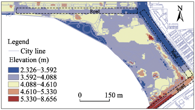
Fig. 8 Elevation of Tanghe Park
Based on DEM data, the park’s slope is extracted using ArcGIS software, and the slope factors are divided into five grades: 0-2°, 2°-4°, 4°-8°, 8°-15°, and >15°. Figure 9 indicates that 71% of the areas in the park exhibit slopes ranging from 0° to 2°, and only 1% of the areas exhibit>15° slopes, which is not suitable for hedging. Therefore, most of the areas in the park are gentle, and 99% of the sites can be utilized as disaster prevention and hedging areas.
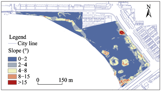
Fig. 9 Slope of Tanghe Park

4.2.1.3 Plant isolation

The fire damage degree is affected by the fire spread speed, whereas the slope directly affects the fire spread speed. The experimental study reveals that the difference in the fire spread speed between the flat slope and the gentle slope between 0 and 20° is limited, and that when the slope exceeds 20°, the spread speed is 2 to 10 times that of the gentle slope (Wang and Zhang, 2014). The aforementioned observation may be rationalized as follows: with the decrease in the infiltration amount of effective precipitation, the soil water content decreases in the area with a greater slope, leading to less water content in vegetation, relatively more plants (e.g., hay and dead grass), and faster forest fire spread in the event of fire (Wang et al., 2020). Therefore, the outer terrain of the city park is designed as a gentle slope. Combined with vegetation planting, the fire isolation belt is installed, thereby isolating the fire and protecting the park. According to the slope analysis of Tanghe Park (Fig. 9), the relief degree of the park’s northeastern and southeastern edges is between 2° and 8°, which is suitable for setting fire forest belts. The current trees in the south direction of the park are Sophora japonica, boxwood, and shrubs with strong fire resistance; however, young pinus vulcanis with poor fire resistance are also present. The current trees in the park’s north direction are Ginkgo biloba with high water content (Fig. 10), and its linear planting method exhibits a low radiant heat shelter ratio (Wang et al., 2013), which can reduce the fire resistance effectiveness.
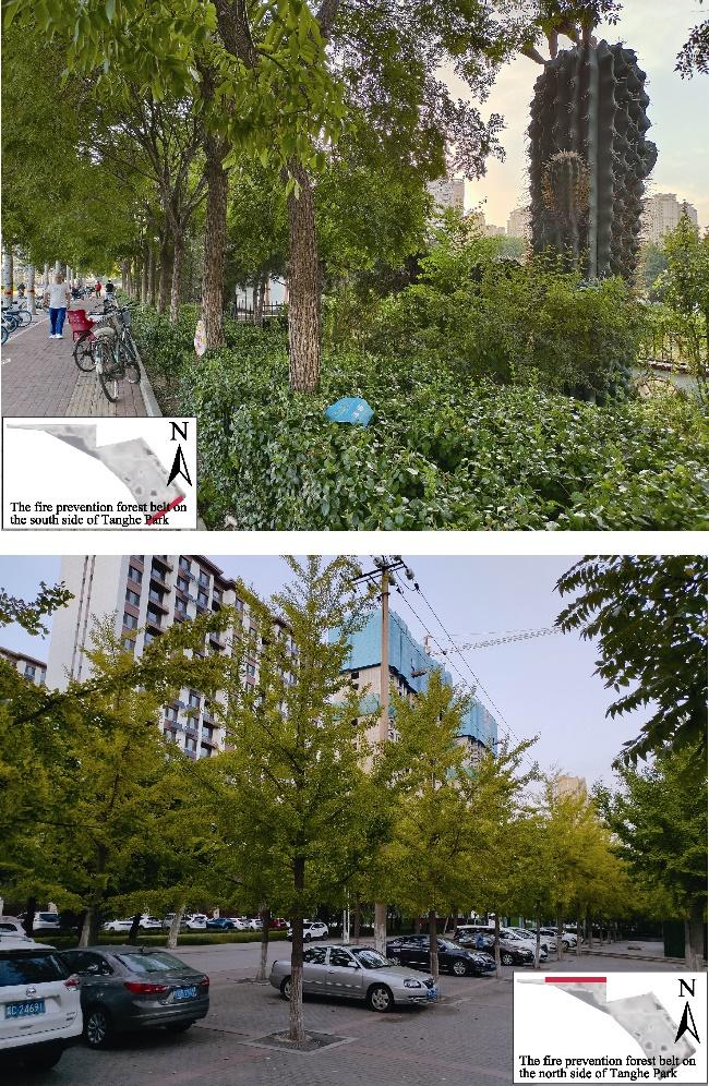
Fig. 10 Outer fireproof forest belt

4.2.1.4 Analysis of refuge area

The demand for asylum is affected by population density and by the refuge area in parks. The higher the population density, the smaller the refuge area per capita in parks, and the higher the demand. The vector data pertaining to the subdistrict administrative divisions of Haigang District is established using ArcGIS, and the population density data layer of Haigang District is generated by inputting the census data of Haigang district into corresponding streets. The layer is set as a 50 m×50 m cell network through raster, and Formula (1) is substituted to calculate the average serving population density of the 6 streets covered in the buffer zone of Tanghe Park as 48799 individuals (Fig. 11). Deducting the area of water which should not be utilized as disaster prevention in the park, the area of the steep (>15°) slope, the fixed building area in the park, and the area of building collapse, the effective refuge area in the park is approximately 96132.7 m2, referring to the requirements of the per capita effective refuge area (≥2 m2) in Table 1, and does not consider the plant area. Because the park area can meet the needs of 46602 individuals, the actual area is not sufficient to meet the population density covered by the park.
$ N=\sum \bar{P} \times n \times s / 10^{6}$
where, N denotes the average density of total service population (individuals); $ \bar{P}$denotes the average population density per street (individuals); n denotes the number of each street grid; and s denotes the area (m2) of grid cells (50 m×50 m=2500 m2 herein).
Fig. 11 Population density

4.2.1.5 Hazard source analysis

The vector data of the buildings in Tanghe Park are derived from the mapping data of the waterbeam map downloader. The ArcGIS buffer analysis tool is utilized for calculating the influence range of building collapse, utilizing 50% of the height of the surrounding buildings as the radius. When an earthquake occurs, there are still vehicles driving on the roads; therefore, the road is a crucial emergency evacuation and rescue channel. The collapsed building located in the northeast of the park covers the first-level road entrance and exit of the park (Fig. 12). Although the second-level road located in the north can be chosen, there are multiple steps, which affect the traffic patency, thus somewhat reducing the rescue efficiency. The collapse of buildings in other directions did not affect the park.
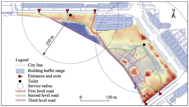
Fig. 12 Buffer of surrounding buildings
If the gas station POI data of Baidu Map is utilized as a reference, a 100 m buffer is established, and the result is depicted in Fig.13. The gas station's danger area does not affect Tanghe Park. Based on historical data analysis, Datang River, located in the south of Tanghe Park, does not represent an area with high flood risk. However, considering the impact of river surges and surges during flood season and global climate change, which may exacerbate the frequency and intensity of floods, it is necessary to strengthen protection preparations. According to the analysis of the 100m buffer range of Datang River, part of Tanghe Park is located in the flood risk zone. Consequently, it is necessary to strengthen, reinforce, and update the existing flood control facilities in the park.
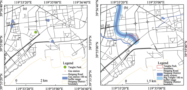
Fig. 13 The hazard influence range around Tanghe Park (a) Gas station, (b) Flood risk areas

4.2.1.6 Security environment analysis

By conducting field investigation, the study finds that there is a lack of an effective security system and emergency plan in the park. Currently, the security personnel in the park mainly focus on dissuading citizens from jumping over railings or going to potentially dangerous areas such as deep water, and fail to consider the multiple, high-probability, and sudden incidents that affect the system’s normal operation, as well as the emergency plan and response mechanism under normal extreme weather conditions. In addition, the existing park management staff is insufficient, and problems (i.e., difficulties barring citizens from seek for help) exist.

4.2.2 Accessibility analysis

4.2.2.1 Space accessibility

Although Tanghe Park meets the requirement on the number of evacuation places, they are mainly concentrated in the north and south side, and the east side has no entrance; therefore, owing to poor accessibility, Tanghe Park is not conducive to evacuation. Moreover, parts of the park evacuation route connection points are not smooth and do not meet the barrier-free access design standards, thereby affecting the patency of evacuation. The first and second grade park roads in the park do not meet the requirements of “Design Code for Disaster Prevention and Refuge Places”, namely that the main channel should be ≥7 m and the secondary channel should be ≥4 m; therefore, it is necessary to adjust the existing plants on both sides of the road and to widen the rescue road in case of disaster.
The main and secondary roads with main traffic functions and no less than 20 meters are often utilized as evacuation channels for disaster relief. Figure 14 indicates that Tanghe Park is < 500 m away from the urban main road (west section of Hebei Avenue). In case of disaster, this road can be converted into a rescue channel and an evacuation channel to ensure the passage of disaster relief vehicles, the delivery of emergency materials, and the evacuation of personnel.
Fig. 14 Distribution of main roads around Tanghe Park

4.2.2.2 Rescue accessibility

(1) The distance to fire station
If Baidu Map fire station POI data is considered as the reference point, GIS is utilized to establish 1 km and 3 km buffer zones respectively, and the distance from the park to the fire station is analyzed. The results (Fig. 15) indicate that the 1 km service range of a fire station could cover the park.
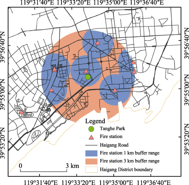
Fig. 15 Distribution of fire station service area around Tanghe Park
(2) The distance to hospital
GIS buffer analysis is conducted on the POI data of hospitals obtained from Baidu Map (Fig. 16). Therefore, the service range of four medical facilities could cover the Tanghe Park with the 1 km linear distance as the buffer zone. There are 32 hospitals within 3 km of Tanghe Park, indicating that there are abundant medical service resources situated around the park.
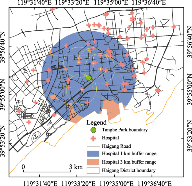
Fig. 16 Distribution of medical services around Tanghe Park

4.2.3 Infrastructure

4.2.3.1 Living facilities and medical facilities

(1) Living facilities
The living facilities in the disaster prevention park mainly include domestic water, electricity, emergency toilets, and tent accommodation facilities. Currently, the water resource availability in the park is relatively low, and the existing water supply system is apparently an insufficient method of responding to emergencies. The emergency measures of the power system are not sufficiently considered. There is only one emergency lighting facility comprising a solar photovoltaic battery, which is prone to collapse in disaster. Shelter facilities, sewage facilities, and temporary toilets are critically insufficient for meeting the needs of emergency shelters in times of disaster (Fig. 17).
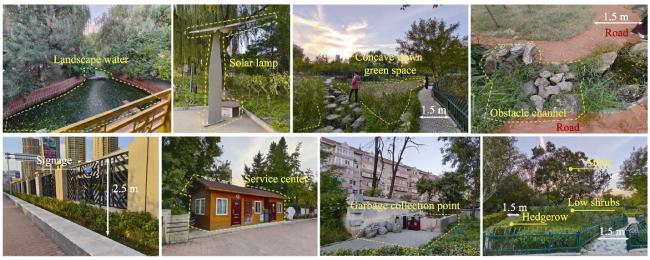
Fig. 17 Current scenario of Tanghe Park infrastructure
(2) Medical facilities
Facilities that usually exist for other purposes and can be urgently requisitioned in special periods are referred to as “rapid emergency medical facilities”, which are exceedingly crucial rescue facilities when public health events and major disasters occur. However, there are no special emergency medical and epidemic prevention places and facilities in the park.

4.2.3.2 Command and publicity facilities

(1) Command facilities
An independent command center has not been established in the park, and a service center is installed at the southeast entrance. Indoor broadcasting, image monitoring, and wired communication equipment are complete, but not comprehensively covered in the park. In addition, due to early construction, most of the equipment pertaining to the service center is old and exhibits poor compatibility; thus, it is impossible to achieve the interconnection of basic information such as the disaster scenario, rescue force input, and material reserve.
(2) Publicity facilities
The contents of the publicity board in the park are mostly legal education for citizens and civilized etiquette, and only a layout map of the park exists at the entrance; the lack of standard indicating tools indicates that facilities are relatively simple and are not eye-catching. In the event of a disaster, residents’ judgment and action decline owing to panic and a lack of error-free instruction facilities; thus, it is difficult to achieve a safe, orderly, and calm refuge.

4.2.3.3 Fire-fighting facilities

The landscape water body in the park and in the west of the Datang River can be utilized as fire water; however, the impurities in the water should be treated to prevent excessive blockage of the fire water supply network. Although there are special fire protection channels in the park, there are insufficient emergency fire protection facilities such as firefighting tools and equipment.

4.2.4 Evaluation result

Based on the preceding analysis, disaster prevention and resilience evaluation is performed on 13 indicators pertaining to the three dimensions of the park. The disaster prevention and resilience evaluation scores that indicate Tanghe Park’s safety, accessibility, and infrastructure are 3.6362, 1.8183, and 1.2603, respectively, and the total score pertaining to the comprehensive disaster prevention and resilience of Tanghe Park is 6.0195. The evaluation level is “general”, indicating that there is still a large optimization space in the disaster prevention enhancement and avoidance resilience functions of Tanghe Park, especially in the infrastructure dimension; thus, the park’s disaster resistance capability should be further enhanced as a method of effectively reducing the damage occasioned by disasters. The results indicate that the contribution values of disaster prevention resilience criteria are ranked as follows: 1) Safety: topography and landforms> hazard source> geological conditions> refuge area> plant isolation> security environment; 2) Accessibility: space accessibility> rescue accessibility; and 3) Infrastructure: living facilities> medical facilities> firefighting facilities> command facilities> publicity facilities.

5 Suggestions and countermeasures

Based on the preceding analysis, it can be observed that there is a spatial mismatch between the park green space resources and the population distribution in the harbor area, and that the difficulty with which the current park green space layout comprehensively meets the population shelter needs during the disaster is increased. Based on the park disaster prevention toughness evaluation results, the park’s comprehensive disaster prevention toughness can be described as follows: the safety level and accessibility condition is quite satisfactory; and park site safety, away from the earthquake fault zone and disaster-prone area, is favorable. Moreover, although the terrain slope is relatively gentle, the natural catchment ability is insufficient, and failed to through the terrain construction and plant configuration, combining the disaster prevention function and landscape function. The safe and effective refuge area is insufficient, and there is a lack of sufficient open space, inducing an insufficient bearing capacity in the event of a disaster. The infrastructure dimension conditions are not excellent: the emergency facilities are not configured, indicating that the functions should be enhanced; the emergency management is absent; and the intelligent emergency plan cannot be dynamically generated according to the actual disasters scenario. The comprehensive evaluation results indicate that in the park, there is still a large room for optimization and improvement in the design of disaster prevention toughness. Therefore, the following proposals are offered:

5.1 Optimizing the human-oriented spatial layout and building a nested disaster prevention network system

Human-orientation is the basic requirement, value measure, and core meaning of urban development and spatial resource allocation. The distribution of population density and access preference directly affect the number and frequency of users of green space in disaster prevention parks. Therefore, the location of parks should be rationally distributed according to the urban structure and population distribution, thereby meeting the needs of urban residents who can reach refuge places as soon as possible after disasters. In addition, based on the urban structure, a hierarchical nested network system with relatively independent and multi-level coordination of each district is formed to ensure that when disasters occur and when traffic is affected, each district possesses its own system aimed at ensuring the need for risk aversion is met.

5.2 Strengthening comprehensive defense against multiple disasters and stabilizing the ecological security function

Disaster prevention parks effect different roles in the process of disaster prevention, disaster avoidance, disaster relief, and post-disaster reconstruction. Disaster prevention and landscape, ecology, and recreation and other multi-functional balance factors pertaining to the “plain-calamity combination” principle fundamentally guide the park green space disaster prevention function; thus, construction is enhanced. In the improvement and reconstruction of disaster prevention and the resilience function of urban parks, factors such as the current scenario of the park site, topography, and surrounding environment should be comprehensively combined; and landscape elements (e.g., park road, square green space, facilities, water features, and plants) should be utilized as the breakthrough point, combined with vertical terrain design, while strengthening comprehensive disaster prevention, reduction, and emergency functions. It is also necessary to enhance the park’s ecological conservation, landscape beautification, leisure, and recreation functions, and to enhance the resilience of the regional ecological environment as a whole from the improvement of disaster prevention functions.

5.3 Increasing the safe and effective escape area and enhancing the functional space layout of parks

The size of the effective refuge area determines the living space and refuge conditions of the asylum workers. Since the area of park land breaks through the red line with considerable difficulty, the proportion of open space, semi-open space, and covering space in the park can be appropriately increased when the disaster prevention and resilience function is improved, and certain effective space can be released through plant allocation and facility layout. Moreover, the functional connection of each space should be strengthened to realize functional complementarization, thereby facilitating the efficient utilization of various resources in the park during disasters. Moreover, the refuge space-park combination should be comprehensively considered to avoid the repetition of configuration and functional conflict, and to avoid unsafe spaces such as the building collapse danger zone.

5.4 Replenishing emergency infrastructure resources and establishing dynamic emergency management plans

Emergency infrastructure includes six types of facilities: emergency shelter, public security management, medical and sanitation, public sanitation, emergency water, and electricity and material storage. It is difficult for the infrastructure of ordinary parks to support the living security of folk houses during disasters. Therefore, when improving the disaster prevention and resilience function of parks, the city’s comprehensive disaster prevention capacity and overall rescue system should be considered, combined with the functional positioning of disaster prevention parks, disaster prevention facilities should be evaluated, emergency infrastructure resources should be supplemented, and multi-functional facilities should be added from the plain-calamity combination perspective. This strategy can not only effect the role of urban landscape in peacetime, but also perform functional transformation in time of disaster. For example, the variable multifunctional seats can be utilized for storing disaster relief supplies and temporary cooking stoves (Shen and Saito, 2007). In addition, an intelligent operation system can be implanted in the existing facilities and equipment, and artificial intelligence can be utilized to construct an intelligent emergency plan system, which can automatically generate a preliminary solution after extracting critical accident-related information.

6 Conclusions

Global climate change has led to increasing natural risks and frequent urban disasters. Therefore, the park has gradually become a crucial location for refuge and evacuation against disasters. By analyzing the spatial distribution of urban park green space from the disaster prevention and avoidance perspective, the urban comprehensive disaster prevention ability can be enhanced, and by evaluating the disaster prevention and avoidance ability of parks, the focus and direction of improving the resilience of park green space can be clarified.
However, it is often difficult to predict residents’ refuge behavior when disasters occur, and their behavior directly affects the emergency capacity of refuge places (Chen et al., 2019). Therefore, in subsequent studies, factors such as the characteristics of residents’ refuge behavior and the connectivity with other urban disaster prevention spaces should be considered; thus, disaster prevention and the avoidance ability of park green space can be comprehensively evaluated.
[1]
Alawi M, Chu D, Hammad S. 2023. Resilience of public open spaces to earthquakes: A case study of Chongqing, China. Sustainability, 15(2): 1092. DOI: 10.3390/su15021092.

[2]
Anhorn J, Khazai B. 2015. Open space suitability analysis for emergency shelter after an earthquake. Natural Hazards and Earth System Sciences, 15(4): 789-803.

[3]
Bing Q L, Li X, Luo Y. 2017. Urban disaster prevention plan with resilient city theory. Planners, 33(8): 12-17. (in Chinese)

[4]
Brown R D, Vanos J, Kenny N, et al. 2015. Designing urban parks that ameliorate the effects of climate change. Landscape and Urban Planning, 138: 118-131.

[5]
Cai K Z. 2018. Urban design strategies to enhance safety of space in disaster prevention based on the spatio-temporal process of emergency evacuation and refuge in urban blocks. Architectural Journal, (8): 46-50. (in Chinese)

[6]
Carter J G, Handley J, Butlin T, et al. 2018. Adapting cities to climate change-exploring the flood risk management role of green infrastructure landscapes. Journal of Environmental Planning and Management, 61(9): 1535-1552.

[7]
Chen C, Cheng L, Xiu C L. 2019. Research progress and prospect of urban shelters. Journal of Catastrophology, 34(4): 165-171. (in Chinese)

[8]
Chen L, Hu X J, Chen C Y, et al. 2016. Study on transformation of urban disaster prevention and reduction functions: A case study of Tiger Hill Park in Dongshan Island of Fujian Province. Journal of Central South University of Forestry & Technology, 36(7): 134-140. (in Chinese)

[9]
Chen L H, Li L F, Wu F, et al. 2020. Evaluation of the geological hazard vulnerability in the Beiliu City based on GIS and information value model. Earth and Environment, 48(4): 471-479. (in Chinese)

[10]
Chen M X, Xian Y, Wang P L, et al. 2021. Climate change and multi-dimensional sustainable urbanization. Acta Geographica Sinica, 76(8): 1895-1909. (in Chinese)

DOI

[11]
Chu J Y, Ma D X, Su Y P. 2013. Study on site selection of resident emergency congregate shelters based on combination weighting TOPSIS. China Civil Engineering Journal. 46( S2): 307-312. (in Chinese)

[12]
Cui Y G, Pan H, Tan W H, et al. 2022. Research on service performance evaluation of urban disaster prevention park green space: Taking Fuzhou Central City as an example. Journal of Minjiang University, 43(2): 118-128. (in Chinese)

[13]
Fan X, Qin Y Y, Gao X. 2021. Interpretation of the main conclusions and suggestions of IPCC AR6 Working Group I Report. Environmental Protection, 49(17): 44-48. (in Chinese)

[14]
Fei W, Wu J, Shi Y, et al. 2020. Construction of disaster prevention capability evaluation framework of urban park system: Methodology and its application in China. Journal of Environmental Engineering and Landscape Management, 28(1): 9-19.

[15]
Fei W J, Gao X F. 2020. A review on disaster prevention and reduction function of urban green space in China. Journal of Nanjing Forestry University (Natural Sciences Edition), 44(4): 222-230. (in Chinese)

[16]
General Office of the Ministry of Housing and Urban-Rural Develop-ment of the Individuals’s Republic of China. 2018. Guidelines fordesign of urban green space disaster prevention and refuge. https://www.mohurd.gov.cn/gongkai/fdzdgknr/tzgg/201801/20180112_234781.html. Viewed on 2022-11-12. (in Chinese)

[17]
Ji J, Shi W H, Nie L, et al. 2019. Quantitative evaluation method of service quality of urban disaster prevention park. Urban Development Studies, 26(9): 20-24. (in Chinese)

[18]
Ji W J, Qu J S, Xu L. 2021. Disaster mitigation capacity evaluation of emergency shelters of Lanzhou City based on AHP and GIS techniques. Remote Sensing Technology and Application, 36(4): 948-958. (in Chinese)

[19]
Kawlra G, Sakamoto K. 2023. Spatialising urban health vulnerability: An analysis of NYC’s critical infrastructure during COVID-19. Urban Studies, 60(9): 1629-1649.

[20]
Li J M, Liu X, Yao X H, et al. 2018. Challenges and countermeasures of the security event monitoring and early warning in the national park—Based on the research of multi-source information integration sharing. Science & Technology for Development, 14(9): 849-856. (in Chinese)

[21]
Liang H Y, Xiao R B, Liao Y T. 2010. Evaluation of reasonable city parks distribution based on service ability. Chinese Landscape Architecture, 26(9): 15-19. (in Chinese)

[22]
Lu Y R, Deng J F, Han G F, et al. 2022. Research on dynamic evaluation of multidimensional accessibility to urban park. Chinese Landscape Architecture, 38(5): 92-97. (in Chinese)

[23]
Lv W, Han Y F, Zhou W N, et al. 2023. Study on the spatial correlation between the suitability evaluation of emergency shelter and the service scope. Journal of Safety and Environment, 23(3): 694-703.

[24]
Ma Y, Liu B, Zhang K, et al. 2022. Incorporating multi-criteria suitability evaluation into multi-objective location-allocation optimization comparison for earthquake emergency shelters. Geomatics, Natural Hazards and Risk, 13(1): 2333-2355.

[25]
Ma Y J, Su Y P, Liu R X. 2005. Assessment of safety of urban parks for disaster prevention. Safety and Environmental Engineering, (1): 84-86. (in Chinese)

[26]
Mu B, Xing L H, Tian G H. 2020. Adaptation and response of green land ecosystem from the perspective of urban disaster prevention and control. Journal of Henan Agricultural University, 54(5): 862-870. (in Chinese)

[27]
Ning Y H, Yao X. 2021. Design and implementation of emergency command system. Computer Science, 48(S1): 613-618, 628. (in Chinese)

[28]
Pokhrel S. 2019. Green space suitability evaluation for urban resilience: An analysis of Kathmandu Metropolitan City, Nepal. Environmental Research Communications, 1(10): 105003. DOI: 10.1088/2515-7620/ab4565.

[29]
Şenik B, Uzun O. 2021. An assessment on size and site selection of emergency assembly points and temporary shelter areas in Düzce. Natural Hazards, 105: 1587-1602.

[30]
Shen Y, Saito J. 2007. Inspirations from the disaster prevention with public green space in Japan. Chinese Landscape Architecture, (7): 6-12. (in Chinese)

[31]
Song Y, Xie K, Su W. 2019. Mechanism and strategies of post-earthquake evacuation based on cellular automata model. International Journal of Disaster Risk Reduction, 34: 220-231.

[32]
Tang H L, Tian Y P, Kang C X. 2020. Sign setting of emergency shelter under the background of beautiful rural. Packaging Engineering, 41(12): 236-240. (in Chinese)

[33]
Villagra P, Rojas C, Ohno R, et al. 2014. A GIS-base exploration of the relationships between open space systems and urban form for the adaptive capacity of cities after an earthquake: The cases of two Chilean cities. Applied Geography, 48: 64-78.

[34]
Wang J B, Dai S Z, Gou A P. 2014. Emergency service evaluation and planning measures of evacuation space. Planners, 30(10): 104-109. (in Chinese)

[35]
Wang L M, Zhang X L. 2014. Impact analysis of forest fire safety in Badaling Forest Centre of Beijing. Forest Resources Management, (6): 170-174. (in Chinese)

[36]
Wang W G, Chen J W, Su Y P. 2013. Analysis of the design and function of fire prevention forest belts in fire prevention park. Safety and Environmental Engineering, 20(3): 32-35, 41. (in Chinese)

[37]
Wang X. 2019. Research on the suitability of the emergency shelter in Tianjin. Amsterdam, The Netherlands: Atlantis Press.

[38]
Wang Y J, Zhang J Y, Hou J W. 2020. Location selection methods of mountain forest fire monitoring points based on terrain analysis. Forest Resources Management, (2): 135-140. (in Chinese)

[39]
Wong N H, Tan C L, Kolokotsa D D, et al. 2021. Greenery as a mitigation and adaptation strategy to urban heat. Nature Reviews Earth & Environment, 2(3): 166-181.

[40]
Wu J Y, Cai Q Y, Chu J Q, et al. 2015. Function evaluation and planning strategies for disasters prevention of urban greenland: Taking Wuhan City for example. Urban Problems, 241(8): 33-38. (in Chinese)

[41]
Xing L H, Wang Y Q, Liu M S, et al. 2020. Evaluation on the balance of park greenspace and residential population distribution in the major urban area of Zhengzhou City. Journal of Northwest Forestry University, 35(3): 258-265. (in Chinese)

[42]
Xu H Q, Tan J K, Li M Y, et al. 2022. Compound flood risk of rainfall and storm surge in coastal cities as assessed by Copula formal. Journal of Natural Disasters, 31(1): 40-48. (in Chinese)

[43]
Xu X, Zhang J G. 2020. Visualization of domestic urban greenland disaster prevention and reduction based on knowledge mapping method. Journal of Southwest China Normal University (Natural Science Edition), 45(9): 51-58. (in Chinese)

[44]
Ye M W, Wang J, Chen Z L, et al. 2010. Suitability evaluation of urban green park for earthquake disaster prevention and refuge based on 3S technology. Journal of Natural Disasters, 19(5): 156-163. (in Chinese)

[45]
Zhang C Q, Zhang B, Li W H, et al. 2012. Analysis of the disaster prevention and reduction functions of urban greens paces in Beijing City. Geographical Research, 31(12): 2301-2309. (in Chinese)

[46]
Zhang Y Y, Sun Y T, Yao C H. 2019. The application of spatial syntax in the accessibility study of urban parks—A case study of Wuhan. Chinese Landscape Architecture, 35(11): 92-96. (in Chinese)

[47]
Zhao J M, Shen W K, Li M, et al. 2016. Seismicity feature and seismic risk in the future of Qinhuangdao Area. North China Earthquake Sciences, 34(1): 70-75. (in Chinese)

[48]
Zhu L J, Su Y. 2013. Assessment of safety of disaster-prevention parks: A case study of Bishagang Park. Chinese Agricultural Science Bulletin, 29(7): 191-196. (in Chinese)

DOI

[49]
Zhu P J, Zhang J, Xiao H, et al. 2010. Emergency refuge function of urban green space: GlS-based pattern optimization. Journal of Natural Disasters, 19(4): 34-42. (in Chinese)

Outlines

/