Disaster Prevention and Pollution Control

Urban and Rural Flood Adaptation and Its Planning Application in Floodplains

  • JIA Meng , 1, 2 ,
  • ZHANG Yue , 1, *
Expand
  • 1. School of Architecture, Tsinghua University, Beijing 100084, China
  • 2. Architecture Design & Research Institute Ⅰ, China Architecture Design & Research Group, Beijing 100044, China
* ZHANG Yue, E-mail:

JIA Meng, E-mail:

Received date: 2023-05-15

  Accepted date: 2024-01-03

  Online published: 2024-12-09

Abstract

Humanity’s struggle with floods has revolved around living near water bodies and attempting to prevent and control inundations. With the expected increase of floods in the future due to global climate change and acknowledging the rising uncertainty of weather phenomena, humans should learn to cope with natural floods. Gilbert F. White’s flood adjustment approach, which is used in floodplain management, can harmonize the relationship between humans and floods by regulating people’s development behavior in floodplains and adjusting the management of land use and the flood resistance standard of buildings in such areas so as to alleviate flood disasters and promote the coordinated development of the economy, society, and environment in these areas. The US, EU, France, and the Netherlands have formulated relevant policies and implemented practices under the guidance of White’s principles. In recent years, flood resilience theory and resilience planning have become the focus of flood management. However, flood adjustment still has some limitations, such as lack of independence, lack of comprehensiveness and systematization, limited application scenarios, unresolved contradiction with human survival and development needs, and an insufficient spatial scale, necessitating further research and verification. Cities in the floodplains of China should learn to harmoniously coexist with floods and thus achieve ecological environmental protection and sustainable development through flood adaptation planning of urban-rural integration.

Cite this article

JIA Meng , ZHANG Yue . Urban and Rural Flood Adaptation and Its Planning Application in Floodplains[J]. Journal of Resources and Ecology, 2024 , 15(6) : 1488 -1501 . DOI: 10.5814/j.issn.1674-764x.2024.06.008

1 Introduction

The past few decades have seen rapid population and economic growth in flood-prone areas, leading to a fast increase in the human and economic costs of floods globally (UNISDR, 2009). Between 1980 and 2013, floods caused more than 220000 deaths worldwide, with direct economic losses exceeding USD 1 trillion. With increasing effects of climate change (Solomon et al., 2007), floods are expected to continue to increase in frequency and intensity in the future (Werritty, 2006). Consequently, there is growing concern regarding flooding, its long-term negative impacts on economic growth, and the hazards, risks, and disaster management associated with it. Social and economic development factors have a far greater impact on flooding than climate change, and if no measures are taken, flood-related losses could increase 20-fold by the end of the 21st century (Winsemius et al., 2016).
Frequent flood disasters have led people to rethink the reasonableness of singularly targeted flood control engineering measures and actively seek other solutions. Geographers White et al. (2001) have summarized a variety of explanations behind the increase in flood losses, arguing that the basic dilemma of flood hazards lies in the imbalance between flood exposure, response, and adaptation capacities during the use and development of floodplains (IPCC, 2011). Human beings should not try to control nature but rather should learn to live harmoniously with naturally occurring floods (White, 1942; Burton, 1962; Burton et al., 1978).
In the early 21st century, the flood management community embraced the ideas of White et al., recognizing that sustainable flood mitigation solutions must be achieved through integrated action (White, 1993; APFM, 2003; UNDP, 2004; UNISDR, 2004; Cheng, 2005). There has been a major shift in flood risk management worldwide: from a control-oriented approach to flood prevention to a risk-based, holistic approach with an emphasis on a systems perspective and sustainability (Harvey et al., 2009; Green, 2010).
China has a large population, most of which live in the floodplain and valley plain. The conflict between people and floods, which has a long history, has been exacerbated due to the increase in population and the acceleration of urbanization. Historically, destructive and frequent floods have had a major impact on urban development. Understanding how people cope with floods, how cities expand under the threat of floods, and how modern urban and rural construction learn lessons from historical floods in the context of global climate change all require urgent and in-depth research.
In order to solve this problem, based on Gilbert F. White’s flood adjustment theory (White, 1942), this paper reviews research on the subject of flood adaptation, flood adjustment, flood resilience, and floodplain management, covering ancient literature and research done over the last 30 years. This study reviews four typical historical flood adaptation measures and examines planning applications across different countries with varying economic development levels. The paper does a comparative analysis of these measures in order to provide suggestions for establishing flood adaptation planning models in China.

2 Review of the history and development of flood adaptation

2.1 Settlement proximity to flood-prone areas

Rivers play an important role in the history of human civilization. Globally, agricultural settlements are often distributed along rivers and floodplains, providing abundant food for surrounding urban dwellers, and these settlements are often flooded. Studies on the relationship between cities and floods in historical periods have shown that almost all early cities originated in river regions (Gregory et al., 2019). Places near river deltas and crossroads are preferred for new city sites (Cronon, 1991). Cities in the Rhine Delta are denser than those located farther upriver (Disse and Engel, 2001; Glaser and Stangl, 2003).
A city is a spatial aggregation of population, production, and other factors. In the agricultural era, human life, production, agricultural development, and urban construction all needed a large number of water sources. Most cities around the world are built along rivers and rely on flowing water for sustenance, drainage, and transportation. Flowing water provides transportation and enables handicraft production, commerce, and personnel exchanges. There is a close relationship between the rise and development of cities and rivers and floods.
Although floods have a negative impact on human beings, they make the soil fertile and the land flat, facilitating agricultural production (Mumford, 1961). The world’s first cities were built on the floodplains of the Tigris and Euphrates rivers. Subsequently, early urban civilization expanded into the flood-prone Nile, Indus, and Yellow River valleys, causing an urban revolution (Childe, 1950). Richard White points out that, in the abstract, river flow and human labor are different manifestations of energy. Human efforts in controlling a river make humanity closely connected, even inseparable, from the energy of the environment. Floods and cities have always maintained a symbiotic relationship of dynamic balance. Upstream rivers in the UK benefit from mild rainfall throughout the year, producing a relatively stable flow with low sediment content that feeds canals and navigable rivers, while rivers in countries such as China and India have more seasonal flow regimes, more extreme flooding, and higher sediment loads (Tvedt, 2021). Research in Europe has focused on the Rhine, Danube, and several major rivers in Spain and Italy, examining historical floods to explore the impact of flooding on urban development.
Petrić et al. (2018) studied policies concerning settlement relocation along the Drava River, a tributary of the Danube, after floods since the 16th century. They found that although floods have threatened the life and property of local residents, they have also endowed the land with nutrient-rich alluvial. Human society has always had communities that co-existed with floods. These communities function normally during periodic floods and even take advantage of the ecological benefits of floods, exemplifying human adaptation to flooding.
The ancient Chinese people, for a great period of time, had an intuitive understanding of the relationship between cities and floods, as recorded in the Notes on Water Classics. As early as prehistoric times, Chinese cities were spatially distributed near rivers. From the pre-Qin period to the Qing Dynasty, all important cities were characterized by closeness to water and rivers. Moreover, the larger the river flow, the larger the population, the larger the spatial scale, and the higher the level of an adjacent city. Zhang (2003) proposed that no ancient cities in China lacked water. Similarly, Ma (1998) contended that advantageous geographical positions along rivers governed site selection for most cities in China.
Wang et al. (2023) studied the relationship between cities and floods, revealing that the frequency of floods is related to the topography and altitude of a city. Although it was known that a city’s proximity to a river system will lead to serious flooding problems, the spatial distribution of historic cities still tended to be close to rivers. These cities were subject to the sudden and instantaneous nature of floods. Urban site selection was constrained by a lack of suitable options that offered long-term solutions. The relative fertility of the floodplain encouraged people to prefer the risk of flooding to leaving (Burton et al., 1993).

2.2 Early flood prevention strategies

The earliest way for humans to avoid floods was to evacuate to hills and highlands when floods hit. This primitive non- engineering measure was a kind of spontaneous adaptation to floods. Flood avoidance included the use of planning measures to keep buildings away from floodplains as well as the construction of elevated structures or urban flood control works to protect residents when floods came. In China and Europe, the geographical locations of cities were carefully selected to avoid flood threats (Barriendos and Rodrigo, 2006). He (2014, 2020) found that the capitals and provincial capitals of the Qing Dynasty were all distributed in a region near rivers or at the junction of two rivers or along the tributaries of large rivers. These cities could not only have their water needs met but could also avoid floods and other water disasters.
Wu (1995, 2009) systematically studied the flood control strategies, measures, and features of the flood control system of ancient Chinese cities from the perspective of city planning and urban water system layout. He believed that city site selection and perfect urban water system construction were key factors in urban flood control. Flood adaptation with Chinese traditional wisdom has existed since ancient times, and Wu (2009) categorized it as prevention, guidance, storage, elevation, strengthening, and relocation.
Based on the study of flood control strategies in the ancient Yellow River floodplain, Yu and Zhang (2007) summed up the reasons why disasters shaped three different forms of waterlogging and proposed three response strategies to floods: site elevation, construction of walls and levees, and digging pits in low places.
The flood adaptation of Chinese traditional wisdom has led to spatial and temporal symbiosis and synchronization interaction with floods in the limited time and space. On the one hand, space symbiosis and layered sharing, typical cases such as the water network city in Jiangnan area and the concept of Taipingmen (second-floor gates) in South China. Additionally, it is time symbiosis and time-sharing, human activity regulations in detention and retention basins have been observed: when water recedes, people move forward, and when water rises, they move back.

2.3 Victorian municipal engineering outlook on flood control

As productivity increases, reservoirs and levees are built and extended into high-risk areas of floodplains. According to the flood control mindset, people believe that floods should be stopped whenever they happen and that floods mean disaster. Flood control engineering measures have been the most important steps taken by humans to prevent floods over a long historical period, which reached its peak with the development of industrialization in the early 20th century. These measures include the construction of reservoirs, flood storage and detention areas, levees, flood diversion channels, flood diversion areas, and river regulation projects besides engagement in water and soil conservation, establishing emergency measures, and performing storm drainage management.
In Europe, during the Victorian era, engineering measures were regarded as a panacea for all flood management problems. In contrast, in the United States, until the early 1940s, flood protection was largely an individual responsibility, with scant integrated consideration of economic and social resilience at the national or regional level (White, 2008). For example, major government intervention in the Mississippi River was carried out under the US Army Corps of Engineers’ flood control policy, including the construction of levees and other works.
Studies by the Federal Emergency Management Agency (FEMA) concluded that large-scale engineering measures could greatly reduce the impact of flood disasters. Engineering measures are widely believed to have eliminated flood risks; however, flood risks in floodplains are still increasing. The Great American Flood of 1927 was caused by levee failure (Burton, 2008; Hinshaw, 2006). Moreover, residual risks remain and although short-term flood risk has been reduced, the public’s blind reliance on and trust in flood control engineering measures may instead increase long-term flood risk, which may be attributed to a deep-rooted belief in the technological control of nature, leading to a public perception that floodwaters are held back by levees or upstream dams. This perception causes a decline in flood risk awareness, which consequently attracts development to floodplains and leads to increased potential losses (Siegrist and Gutscher, 2008). This phenomenon is known as the levee or escalator effect.
It has been suggested that the expansion of urbanization in floodplains is the main reason behind the increase in flood losses. Studies on the effects of urbanization on hydrological processes began in the 1960s. Research has shown that urban development and increased human activities in Europe have had a significant impact on river runoff, resulting in increased historical flooding (Brázdil et al., 1999). Konrad’s (2003) research shows that urbanization leads to a 100%-600%, 20%-300%, and 10%-250% increase in the flood peak that occurs once in 2 years, 10 years, and 100 years, respectively. Furthermore, Li et al. (2019) showed that the continuous expansion of cities has significantly changed the conditions that contribute to urban flood disasters.
In the study of urban flood control based on the relationship between a city and the environment, water is considered a management element of flood control from a social perspective (Winsemius et al., 2016).
Kondolf and Pinto (2017) studied the relationship between cities and rivers and the social connection function of rivers and pointed out that the connectivity of rivers occurs in horizontal and vertical dimensions. As shown in Table 1, flood control strategies stem from the political top-down considerations and flood control works built along the vertical dimension of a river. These strategies reduce the horizontal connections across the river. The construction of levees, flood walls, storage dams, and other projects severely limit the lateral connection between the two sides of a river and the visual view of the river. Accordingly, Backouche’s (2008) study on the Seine River in Paris in the 18th century pointed out that in order to improve vertical connectivity, the horizontal connectivity between the river and the city was sacrificed.
Table 1 Comparison of river functions and stakeholders in different ages
Age Dimension Contact
dimension
River function Bank type Representative river Problem Stakeholders
Industrial age Area Lengthwise Exploration, development, shipping traffic, and flood control Artificial vertical integration of a bank Mississippi River and Colorado River Ecological influence Central government or capital group
Agricultural age Region Crosswise and vertical Life, fishing, laundry, business, leisure, swimming, and sewage Natural levee Ganges River River
pollution
Local people

2.4 Adaptive concept of harmonious symbiosis with nature

2.4.1 Human adjustment to floods

Gilbert Fowler White (1911-2006), known as the “father of floodplain management” in the United States (Kates and Burton, 2008), pointed out in his book Human Adjustment to Floods that human beings cannot solely rely on single engineering measures to control floods but must adhere to the idea of active human adaptation to and harmonious coexistence with floods. Comprehensive and reasonable measures should be taken to adjust the relationship between human beings and floods, stop the irrational use of urban land space in floodplain areas, and actively avoid the danger of floods (White, 1942).
White is a famous geographer in the United States. He has done extensive research in the fields of geography, public policy, floodplain management, water resources, and environmental protection measures. He served as President Franklin D. Roosevelt’s New Deal cabinet secretary, helping to manage the nation’s environmental and resource affairs. Moreover, White was the president of the Association of American Geographers in 1961, helped draft the National Flood Insurance Act in 1968, and was elected a member of the National Academy of Sciences in 1973. In 1985, the Association of State Floodplain Managers named its highest award in his and Jim Goddard’s honor.
White sees choice as the central dilemma of survival. He famously said that floods are “acts of God”, but flood losses are largely acts of man. Human encroachment on floodplains is the main cause of annual flood losses.
White began a study of floods that involved various disasters and environmental problems; however, we also needed to consider the temporal, political, and philosophical context (Fig. 1). In the 1920s and 1930s, a series of extreme environmental events and the Great Depression occurred in the United States. Roosevelt’s New Deal placed great emphasis on government intervention. Deeply influenced by American pragmatic philosophy and John Dewey, White later founded the “Chicago School” (Burton, 2008) at the University of Chicago to study natural disasters. Changes in political and social consciousness led to a shift in perspective, and White’s “Human adjustment to floods” played a key role in redefining how disasters and human responses are studied.
Fig. 1 The historical background of human adjustment to floods
White adopted a geographical approach to flood response. He looked up the causes of floods in the literature, conducted field trips, and performed analyses of flood area composition. According to White, the flood problem consists of four basic elements: the flood, the environmental characteristics of a floodplain, the people who live in the flood plain, and the ways in which the people adapt to floods.
Urbanization often occurs in areas prone to flood hazards. At the heart of the flood problem is how to deal with the relationship between floodplains and developers, that is, how to deal with the relationship between land and people. The increase in flood risk in the floodplain is caused by the long-term disordered and excessive development behavior of people on the floodplain, resulting from the long-term development and extension of competition for land between people and water in the floodplain. Humanity’s adaptation to floods translates to orderly human resistance to floods and flood disasters.
The approach of positive interaction between humans and nature introduces the concept of sustainable development: coexistence with rivers, that is, humans should try to maintain and improve the inherent basic functions of rivers rather than eliminate them; moreover, people should coexist with floods, that is, the construction of a human flood control system should maintain the risk of floods to within a tolerable range rather than eliminate floods.
Specific measures for flood adaptation proposed by White include increasing land elevation, flood mitigation, cost-benefit analysis, emergency measures, structural adjustment, land use adjustment, post-disaster relief, and flood insurance.
The term “non-engineering measure” was proposed in the late 1950s and promoted by White. This term was used in the official documents of the United States in 1964. Although engineering measures for flood control should be implemented, non-engineering measures should also be put in place to obtain comprehensive economic and social benefits.
A comprehensive flood adaptation solution is an exhaustive application of the above engineering and non-engineering measures, thoroughly considering all influencing factors and comparing the benefits and costs of each measure under a unified standard (White, 1942).
White believed that human beings can make a series of adjustments and adaptations in the face of natural disasters, and these adjustments are feasible when individuals or societies have to deal with extreme natural events. These adjustments and adaptations may be transient or become part of the cultural fabric of a society over time (Burton et al., 1993).
In the 1980s, some “radical critics” argued that most disasters were primarily the result of marginalization, poverty, and deprivation rather than extreme meteorological and geophysical conditions (Hewitt, 1983). Recently, research has focused on local peculiarities, looking beyond meteorological and geophysical threats and on social and cultural aspects of risk, including increased resilience and reduced human vulnerability (Chester, 2005; Chester and Duncan, 2010).
As shown in Fig. 2, White’s (1942) flood adjustments have guided the world of natural disaster research and the development of government mitigation policies. In Europe, the Victorian tradition in the field of municipal engineering regarded engineering measures as a panacea for all flood management problems, and it was only in the early 2000s that this change made its way into the realm of public policy, as exemplified in the UK Institution of Civil Engineers report entitled “Learning to Live with Rivers” (Fleming et al., 2001) and the European Union's Water Framework Directive (WFD) 2000/60/EC. This directive seeks to establish comprehensive watershed management plans beyond developing engineering solutions, particularly in the context of climate change. This approach places great emphasis on the cost-benefit analysis of natural variability and flood adaptation schemes.
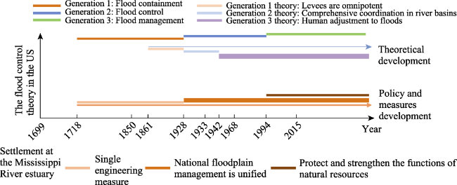
Fig. 2 The development of the flood control act and floodplain management policy in the United States
In the 21st century, non-engineering measures have been widely adopted. Flood insurance and flood warning systems as well as flood risk management and integrated flood management have received increased attention, including in the most prosperous regions and countries such as Europe, the United States, the United Kingdom, Australia, and Japan, which have begun to gradually recognize their significance. As can be seen from the “River Space” and “Natural Building” schemes in the Netherlands and the “Making Room for Water” policy in the United Kingdom, flood hazard mitigation, river restoration compatible with flood mitigation, and river flat restoration have been employed as measures to reduce flood risk downstream. It has also been suggested that agricultural land can coexist with periodic flooding (Opperman et al., 2009). The practice in Yokohama, Japan, shows that flood control and flood adaptation can be implemented simultaneously to prevent flood damage.

2.4.2 Flood resilience

During the 20th century, the world’s population and the proportion of the urban population rose sharply. Industrialization and urbanization brought new problems associated with population, resources, and the environment, which made flood control complicated (Cheng, 2005).
In the 21st century, the role of flood control engineering measures has weakened. However, in practice, many cities continue to rely on these measures to prevent flood damage.
Almost all analyses of future flood risk assume that the future climate will be similar to what it was in the past, treating the world as static. However, historical climate change is unpredictable even on a time scale of decades (Baecher and Galloway, 2021). Milly et al. (2008, 2015) proposed that “stability is dead,” believing that man-made climate change is changing precipitation patterns and flood risk. People are increasingly becoming aware of the impact of climate change. Continued reliance on stability to assess flood risk has been questioned (Fig. 3).
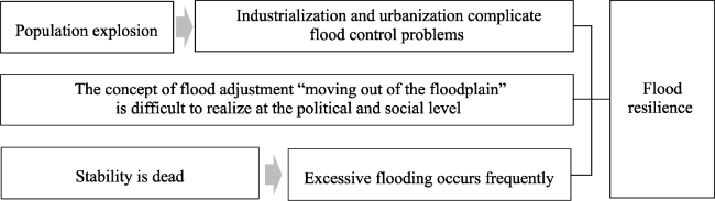
Fig. 3 The background of the concept of flood resilience
Most scientists assume that climate change will lead to a future different from the past. The extent to which flood risk will change in the future is completely unknown. Some believe that certainty is unquantifiable while others believe that it is at least difficult to quantify (Baecher and Galloway, 2021). Cities need to deal with extreme events that exceed the capacity of flood control engineering measures, making strategies to deal with super-standard floods a topic of scholarly inquiry (Cheng, 2020).
It is risky for cities to continue relying on flood control engineering measures to prevent flood damage. Resilience is the best policy for survival in an unpredictable world (Gunderson et al., 2002). Academics are increasingly advocating flood resilience as a key aspect of flood management (Liao, 2012).
Resilience is defined as the ability of a system to maintain its basic function, structure, feedback, and properties while undergoing change (Walker et al., 2004). The resilience of human-inhabited areas to disasters refers to the ability to absorb the effects of disasters and reorganize when damaged (Berkes, 2007). In contrast to engineering resilience, the concept of flood resilience is developed on the basis of ecology and social ecology, which emphasizes the ability to tolerate floods, on the one hand, and the ability to recover and reorganize in the event of physical and socio-economic damage, on the other hand (Liao, 2012). According to Whittle et al. (2010), flood-bearing resilience covers four layers of meaning: resistance, resilience, adaptability, and system self-perfection. Tourbier (2012) defined flood resilience at four levels: spatial, structural, social, and flood risk.
Recent studies on flood resilience emphasize various scales, including land (Vis et al., 2003), region (Miller et al., 2009) and river basins and cities (Schelfaut et al., 2011), encompassing communities, individual buildings, and other dimensions. These studies delve into theoretical constructs, evaluations, and strategic considerations. The incorporation of resilience approaches at the scale of individual buildings underscores the capacity of physical structures to withstand flood disasters. Conversely, the adoption of resilience approaches at the urban and regional levels underscores the accumulation of community experience, placing great emphasis on social structures and spatial characteristics (De Bruijn, 2005; Whittle et al., 2010; Liao, 2012).
Proponents of the flood resilience strategy advocate for an approach in which space is intentionally left for floods and focus is placed on the interaction between humans and nature. The approach includes two types of measures: structural and non-structural. The first measure involves structural approaches such as the development of flood detention areas and green rivers using building materials and other structural measures. Based on an evaluation, Vis et al. (2003), who advocated the use of resilience measures such as “flood detention” and “green river channels”, indicated that resilience strategies are more flexible than resistance strategies besides being more adaptable and offering better long-term benefits. From the residential perspective, Bowker (2007) proposed measures that could mitigate the impact of floods on homes and property even when the said measures could not prevent the total damage caused by floods.
Choi et al. (2010) categorized measures into four categories: runoff management, flood adaptation, water diversion, and construction. The second measure involves non-structural approaches such as watershed management, disaster warning, and public education. Wardekker et al. (2010) and Schelfaut et al. (2011) proposed strategies of flood resilience that primarily comprised risk notification and preparedness, enactment of policies on floods, and the institution of flood management methods.
In practice, flood control and flood adaptation approaches can be implemented simultaneously; however, flood control can compromise flood resilience (Holling and Meffe, 1996; Liao, 2012). Studies on ecosystems and social ecosystems (Folke et al., 2002) have shown that coping with rare, large floods requires situational learning from frequent, small floods. Community-scale flood adaptation projects combined with floodplain restoration approaches (Folke et al., 2010) act as catalysts for dynamic social learning processes in which people observe the hydrology, geomorphology, and ecology of rivers in close proximity. An improved understanding of rivers may eventually lead to the recognition of flooding not only as a hazard but also as a socio- ecological issue. If a community fails to learn, this recognition is prevented and flood control compromises flood resilience (Liao, 2012). In order to gain credibility, the theory on societal learning needs confirmatory evidence from empirical research.
Liao (2014) proposed specific urban flood resilience design strategies from the perspective of architecture, infrastructure, and open space construction, offering the forward-looking argument that existing flood control engineering measures should be completely replaced by non- engineering measures, which is fully forward-looking.
To break the pattern of regular destruction caused by flooding, a new relationship between humans and nature needs to be established urgently. Although flood adaptation measures in modern cities have received increasing attention, research on flood control has been insufficient. Infrastructure that improves a region's flood-bearing capacity at the system level has also not been studied adequately. Whether modern cities can exist in areas that flood is a matter of choice. The paradigm shifts from flood control to flood adaptation approaches faces enormous challenges because existing flood control regimes are difficult to shake, existing levees and dams are complex and expensive to replace or dismantle, and a large-scale change in the status quo seems unlikely in the short term (Liao, 2014).

2.5 Comparison of different flood adaptation measures

In summary, the four flood adaptation measures for flood prevention were not only present in different historical periods that gradually evolved with an increase in human productivity (Fig. 4), but also exist simultaneously in different parts of the world due to differences in economic development, varying levels of sophistication of engineering technology, and different natural geography environments.
Fig. 4 Review of the history and development of flood adaptation
The comparison is shown in Table 2.
Table 2 Comparison of four flood adaptation measures
Flood adaptation measures Time Typical rivers, countries, and regions Economic development level Urbanization rate Man-water-land relationship Purpose Main strategy Advantages Disadvantages
Near-flood settlement 3500 BC-3000 BC Tigris, Euphrates, Nile, Indus, and Yellow Rivers Low Low Flood is the first priority Obtain
benefits from floods
Observe the seasonal rules of floods, evacuate when a flood comes Make the soil fertile and the land flat for agricultural production, transportation Injury to human life, destroys crops and
villages
Build a city wall to avoid flooding 2500
BC
China; Europe Low Low The city is the first priority Use the city wall to protect humans and buildings Site selection in high places, construction of walls, digging pits in low places Using the benefits of near flood, urban population can afford the construction of city wall Need maintenance and strong leadership not robust
Build levees to prevent the flood 18th century The US, Mississippi; Europe Middle High Humanity is the first priority Control floods Sees engineering measures as a panacea for all flood management problems Expansion of urban built-up areas into flooded areas Aggravating flood, destroys the ecological environment
Adequate flooding 1968-present The US; The EU; France; Netherlands; Japan High High Flood is the first priority Balance with nature Floodplain
management
Coexistence with rivers, coexistence with floods Limited land resources are difficult to re-distribute

3 Planning on the application of flood adaptation strategies

Among environmental design strategies, the planning and design practice of “social remolding of the riverfront” consists of flood risk control and river environment-guided urban planning (Kondolf and Pinto, 2017). Other practices involve bringing about environmental restoration and regeneration through urban renewal projects. Tort-Donada et al. (2020) identified, classified, and analyzed major urban river regeneration projects conducted in France and Spain since 1990, developing a summary of common hydraulic engineering approaches to urban renewal. Regarding urban riparian spaces and landscape utilization, Verbrugge and van den Born (2018) found that urban residents pay substantial attention to the landscape significance of rivers.

3.1 Floodplain management planning

In floodplain management, planning involves practices such as flood risk zoning to evaluate spatial distribution, flood land use planning, and flood emergency planning. The planning utilizes a flood risk map and takes into consideration results from a flood risk analysis.
A flood risk map is a forecast flood-coverage map compiled by credible government and academic institutions. It converts the evaluation results of urban flood risk into spatial information that contains economic indicators for public reference. The map is used as a primary reference for government management efforts, flood insurance and compensation evaluations, and the identification of reasonable flood evacuation paths and refuge locations for people.
In floodplain management, social and environmental factors should be considered equally to maintain and enhance a flood area that functions as a natural resource function. The floodplain should be treated as part of the larger ecosystem of the basin; moreover, the living environment should be improved and the water storage depressions in the tidal flats and highlands should be restored. At the national level, coordinated management of water resources in the upper, middle, and lower reaches of the whole basin should be carried out. In addition, the activities of industries involved in shipping, flood control, disaster reduction, and ecosystem management should be closely integrated with actions taken to manage floods.
The United States is a pioneer in floodplain management. It promulgated the Flood Insurance Act of 1968 and the Flood Disaster Prevention Act of 1973, with floodplain management entering the institutionalization stage. In the early 21st century, the US government proposed that all flood control projects should strive to accommodate future flood changes caused by climate change. In 2015, Obama raised flood protection standards but Trump later rescinded the measure. The 2018 National Defense Authorization Act states that additional funds should be directed to projects built in 100-year flood plains that are at risk of flooding two- thirds of a foot above the base flood level. In 2021, Biden issued a presidential order aimed at restoring scientific responses to the climate crisis (Baecher and Galloway, 2021).

3.2 Architectural design

Construction of water-blocking structures is prohibited in a flood passage area. New buildings can be built in the floodplain area, provided that the foundation elevation is higher than the flood level that occurs once in 100 years. Flood insurance covers buildings with walls and roofs but does not cover water buildings, underground buildings, water conservancy projects, and water conservancy facilities.
Some traditional flood adaptation strategies are still valid in modern times. Examples include sublevel stilts, buoyant foundations, flood roofs, impervious floors, flood walls, and the use of waterproof building materials and waterproof seals that resist moisture and mold. A ground floor that serves as an urban open space while accommodating flooding was popularized in Yokohama, Japan. Maasbommel in the Netherlands built buoyant structures or “amphibian houses” located on land. These structures float when flooding occurs (Liao, 2014).

3.3 Infrastructure design

In areas where the rigid structure of established infrastructure makes it difficult to respond quickly to disruptions (Hallegatte, 2009), flood adaptation strategies can be redesigned at the system level using existing technologies to decompose a system into a collection of multiple functional elements that have redundancies and operate flexibly to improve resistance to floods (Fiering, 1982). For example, transport systems can be “amphibious”, with permanent elevated roads built in high-density areas and temporary walkways raised to maintain mobility in low-density areas when flooding occurs. Public boats and amphibious vehicles can also be used to switch back and forth between the two modes of transport.
Proponents of urban resilience advocate for urban planning based on risk assessment, identification of safe areas, and prioritization of infrastructure projects (World Bank, 2012). For example, Japan has built a super levee with a section width of 300 to 500 m in a flood management system that takes into account roads, parks, and buildings. In line with urban resilience, the United Nations International Strategy for Disaster Reduction’s (UNISDR’s) Ten Key Points for Urban Resilience call for resilient infrastructure, fast rebuilding, and superior recovery (UNISDR, 2017). Similarly, New York has emphasized the need for strengthening coastal protection and improving the resilience of infrastructure subsystems such as transportation and communications.
The building of spatial data infrastructure is also important, with such infrastructural systems including INSPIRE, TA2030, Digital Europe, Urban Agenda for the EU, and ESPON (Bilgin and Anbaroğlu, 2022). INSPIRE provides geographic information on factors such as public facilities, environmental monitoring facilities, production and industrial facilities, and agricultural and aquatic facilities as well as energy and mineral resources. The information is used in decision-making to support policy formulation, implementation, monitoring, and evaluation. For example, based on such information, Roberti et al. (2020) carried out research on landslides using artificial intelligence technology.

3.4 Open spaces and urban design

The coexistence of multiple functions can be achieved through design at different times to restore the optimum flood retention functionality of a floodplain. For example, Houston City builds surface retention ponds in floodplains and connects them with river channels. In Europe, sunken grasslands between buildings and large areas of green space set aside by cities are used to store flood water. The areas are called “green rivers”, emphasizing their multiple roles as green spaces and rivers (Vis et al., 2003).
Blakely (2007) proposed that urban design should be done by taking into consideration the geographical location of the study area, its scale of development, and an assessment of natural risks that threaten residential areas due to climate change. In addition, the corresponding urban design guidelines of a specific area should be formulated according to the potential types of natural risks the area faces. Urban design can be used in the rearrangement of different types of open spaces, including in the allocation of frequently used spaces such as playgrounds, parking lots, and high grounds with low flood frequency. The design approach can also be used to establish multi-purpose open spaces such as parks near riverbanks to allow for periodic flooding and to reduce peaks during extreme floods (Liao, 2014). A new design trend is to incorporate flood detention properties in non- green open spaces, where surface and underground channels are interconnected in a network to accommodate large volumes of flood water.
Improving the flood adaptability of cities can enhance the ecological service function of urban rivers. Flood water is introduced into riverside parks and directed into open green spaces and open spaces, re-naturalizing river channels and open spaces, restoring aquatic and riparian habitats, and forming new ecosystems so that green spaces, greenways, and floodplains that are distributed in a city are interconnected with each other to form a unified system that copes with floods. The unification also makes the flood management process more visible, enhancing public awareness and understanding (Verbrugge et al., 2019).

4 Discussion

In floodplain management, the strategy of improving flood adaptation has had a profound impact on flood research, hazard and risk management, environmentalism, and climate change. However, the strategy has some limitations that highlight the need for further research and verification. Regions have unique problems that often require highly specific solutions. China can offer solutions to local and foreign flood-related problems by incorporating Chinese wisdom into research and practice.

4.1 The insufficiency of flood adaptation

4.1.1 Lack of independence, comprehensiveness, and systematicness

Flood adaptation primarily offers value by enabling people to deal with floods, acting as a guiding ideology for flood management. Flood adaptation technology optimizes the combination and selection of various flood control measures after full cost-benefit calculation and economic rationality analyses are conducted. Flood adaptation technology consists of management and decision-making technology that relies on quantitative calculations. However, at present, the available flood adaptation technology cannot be adopted as a complete and independent flood control technology system. Instead, it has to be combined with traditional flood control and drainage engineering systems, with the engineering measures complementing each other.
Factors that influence flooding are complex and variable, and the quantitative relationship between losses and benefits caused by floods also requires highly complex computational models. However, ecology, environmental science, and catastrophology have not yet developed specific methods for the identification of the negative impact of floods on the ecological environment of a floodplain and evaluating the magnitude of its impact. In the face of substantial uncertainty regarding future climate change, it is increasingly difficult to predict the frequency of floods, with the frequent occurrence of non-standard floods making absolute safety impossible. Moreover, quantifying and incorporating the damage to social culture, social psychology, and life endangerment caused by floods into the unified framework of economic cost-benefit analysis is relatively difficult.
Among the various measures of flood adaptation technology, the utilization of non-engineering methods and flood insurance are relatively popular. There is a paucity of research on technical plans and applications, a lack of systematic and mature technical measures and planning schemes, insufficient operable instrumentalized applications, and an inadequate degree of data integration. In the recent past, in-depth flood resilience planning that employs flood adaptation theory has primarily been aimed at resolving socio- political issues. In addition, research has focused on the social space, examining social policies and community support. The engineering technology utilized in flood adaptation needs to be enhanced through the development of the approaches involved and the enhancement of the rate of innovation.

4.1.2 The clash between human survival and development needs has not been fundamentally resolved

Floodplain management strategies and flood adaptation technologies have been created from the development practices involved in the management of the Mississippi River floodplain in the United States. The higher economic prosperity observed in the Mississippi River floodplain is commonly observed in the relationship between floodplains and other areas in the rest of the world. However, the variance in population density, natural environments, river attributes, and levels of economic development of different countries still determine how some countries and regions develop flood areas, with some countries and regions developing these areas to obtain high incomes. But in some other countries, the high population densities and poverty in flood areas compel them to modify the areas in an effort to address the extreme scarcity of land and resources. In many cases, increases in the populations in flood-prone areas compel regions to develop floodplains because land is scarce. The fundamental reason why people develop and settle in floodplains involves efforts to survive, find residences, and achieve economic development.
The main issue in flood management is disaster prevention. However, flood adaptation technology is not developed enough to achieve flood control and disaster reduction in highly urbanized areas and densely populated areas. Flood adaptation technology enables people to stop competing with water for land by reducing losses because it enables them to move and leave flooded areas relatively easily. In densely populated areas, serious problems involving humans and floods over land use are almost inevitable. Consequently, further research is needed on the application of flood adaptation technologies. Despite the acute need for such research, minimal resources have been allocated to the development of the technologies and the long-term practical verification of technological application is lacking.

4.1.3 The spatial scale of flood adaptation is limited

Currently, the spatial scale at which flood adaptation is applied is limited. The scope of discussion regarding the potential flood inundation area on both sides of a river is insufficient. Additionally, the flooding process is not widely viewed as a process involving material and energy exchanges between the land and the natural environment on both sides of a river. It is crucial that the discussion on flooding is expanded to include a broad national space. While flood adaptation also involves the coordination and compensation of the upstream and downstream areas of a river basin, at present, most studies on flood resilience are focused on urban areas. Therefore, research and practice on resilience at large spatial scales needs to be further expanded.

4.2 The flood adaptation model in China

4.2.1 The Chinese traditional flood adaptation model

The key issue in flood planning is the approach of allocating limited land resources to humans and flooding areas. The traditional Chinese flood adaptation model acknowledges the hierarchy involved in the sharing of land resources between humans and water, allocating land resources based on changes in the factors being considered at a given time. The model requires people to surrender land to floods during the flood season and to use the land for agricultural cultivation after water has retreated (Yu and Zhang, 2007; Wu, 2009) (Fig. 5).
Fig. 5 Co-existing with floods under the Chinese traditional flood adaptation model
The Chinese flood adaptation model cultivates harmony with nature, an approach that is in line with the traditional Chinese concept of the ecological civilization of “unity of nature and humans.” From this perspective, flood control and disaster reduction should be transformed into flood adaptation so as to create a sustainable development path where people co-exist with floods.

4.2.2 The flood adaptation planning model in densely populated areas in contemporary China

China has made great strides in the construction of flood control engineering systems, but it still faces substantial flood losses (Xiang et al., 2018) as rapid urbanization continues. While high-quality development approaches and refined management techniques are needed in China’s current stage of economic and social development, it is difficult to apply these approaches and techniques when single engineering measures are involved (Han and Kasperson, 2011).
Flood adaptation planning is an overarching planning appoach for land development, utilization, and spatial layout planning in areas likely to be inundated by floods. In China, under the existing urban and rural built environments and social development strategic planning for high-population- density built-up areas with Chinese characteristics, flood adaptation technology and flood resilience strategies should be employed in the unified planning of the layout of urban and rural areas, particularly in flood-prone areas.
The flood adaptation planning model employed in densely populated areas in contemporary China utilizes strategies such as relocation, storage, and drainage. Relocation refers to the adjustment of the industrial layout of flood plains through land management, while storage refers to the establishment of an effectively integrated urban-rural water network system of ditches, pits, and ponds. Drainage refers to the development of county-scale vertical planning, the establishment of cross-county flood control, and a joint drainage control system (Fig. 6). The specific planning tech niques and methods suitable for China’s national conditions and level of economic development should be explored in practice.
Fig. 6 Application of a model of urban and rural flood adaptation planning in floodplains with Chinese characteristics

5 Conclusions

By examining the issue of flood adaptation, this paper identifies four typical flood adaptation measures employed in different periods and conducts a comparative analysis of the measures. This study examines White’s human adjustment to floods, which influenced the approaches utilized in research, policies, and applications in the US, the EU, and other countries in the past 50 years. The approach proposed by White has similarities with Chinese traditional flood adaptation approaches. China should create a flood adaptation planning model and utilize its associated techniques in the management of urban and rural flood-prone areas, particularly those that are densely populated. The issue of effectively managing flood-prone areas is likely to continue to be a worthwhile research topic in the future.
[1]
APFM (Associated Programme on Flood Management). 2003. Integrated Flood Management: Concept paper (Technical Document No.1). Geneva, Switzerland: APFM.

[2]
Backouche I. 2008. From Parisian River to national waterway. Pittsburgh, USA: University of Pittsburgh Press.

[3]
Baecher G B, Galloway G E. 2021. US flood risk management in changing times. Water Policy, 23(S1): 202-215.

[4]
Barriendos M, Rodrigo F S. 2006. Study of historical flood events on Spanish rivers using documentary data. Hydrological Sciences Journal, 51(5): 765-783.

[5]
Berkes F. 2007. Understanding uncertainty and reducing vulnerability: Lessons from resilience thinking. Natural Hazards, 41(2): 283-295.

[6]
Bilgin G, Anbaroğlu B. 2022. Extending INSPIRE to accommodate urban drone logistics. Geocarto International, 37(26): 12536-12560.

[7]
Blakely E J. 2007. Rebuilding urban places after disaster: Lessons from Hurricane Katrina. Journal of the American Planning Association, 73(3): 357-358.

[8]
Bowker P. 2007. Flood resistance and resilience solutions:An R&D scoping study. London, UK: DEFRA Report.

[9]
Brázdil R, Glaser R, Pfister C, et al. 1999. Flood events of selected European Rivers in the sixteenth century. Climatic Change, 43(1): 239-285.

[10]
Burton I. 1962. Types of agricultural occupance of flood plains in the United States. Diss., Chicago, USA: University of Chicago.

[11]
Burton I. 2008. Gilbert White: Progress in geography. Progress in Human Geography, 32(3): 448-450.

[12]
Burton I, Kates R W, White G F. 1978. The environment as hazard. New York, USA: Oxford University Press.

[13]
Burton I, Kates R W, White G F. 1993. The environment as hazard. London, UK: Guilford Press.

[14]
Cheng X T. 2005. Changes of flood control situations and adjustments of flood management strategies in China. Water International, 30(1): 108-113.

[15]
Cheng X T. 2020. Overall consideration needs to be paid on prevention of exceed standard floods. China Water Resources, (13): 8-10. (in Chinese)

[16]
Chester D K. 2005. Volcanoes, society, and culture. Cambridge, UK: Cambridge University Press.

[17]
Chester D K, Duncan A M. 2010. Responding to disasters within the Christian tradition, with reference to volcanic eruptions and earthquakes. Religion, 40(2): 85-95.

[18]
Childe V G. 1950. The urban revolution. Town Planning Review, 21(1): 3-17.

[19]
Choi G W, Gourbesville P, Río A D. 2010. Analysis of strategies to attain a resilience approach in adaptation to urban flooding. Proceedings of the Korea Water Resources Association Conference. Seoul, Korea: Korea Water Resources Association.

[20]
Cronon W. 1991. Nature’s metropolis:Chicago and the great west. New York, USA and London, UK: W.W. Norton& Co.

[21]
De Bruijn K M. 2005. Resilience and flood risk management. A systems approach applied to lowland rivers. Diss., Delft, Netherlands: Delft University of Technology.

[22]
Disse M, Engel H. 2001. Flood events in the Rhine Basin: Genesis, influences and mitigation. Natural Hazards, 23(2): 271-290.

[23]
Fiering M B. 1982. Alternative indices of resilience. Water Resources Research, 18(1): 33-39.

[24]
Fleming G, Frost L, Huntington S, et al. 2001. Learning to live with rivers. London, UK: The Institution of Civil Engineers.

[25]
Folke C, Carpenter S R, Elmqvist T, et al. 2002. Resilience and sustainable development: Building adaptive capacity in a world of transformations. AMBIO, 31(5): 437-440.

DOI PMID

[26]
Folke C, Carpenter S R, Walker B, et al. 2010. Resilience thinking: Integrating resilience, adaptability and transformability. Ecology and Society, 15(4): 20-28.

[27]
Glaser R, Stangl H. 2003. Historical floods in the Dutch Rhine Delta. Natural Hazards and Earth System Sciences, 3(6): 605-613.

[28]
Green C. 2010. Towards sustainable flood risk management. International Journal of Disaster Risk Science, 1(1): 33-43.

[29]
Gregory S, Wildman R, Hulse D, et al. 2019. Historical changes in hydrology, geomorphology, and floodplain vegetation of the Willamette River, Oregon. River Research and Applications, 35(8): 1279-1290.

DOI

[30]
Gunderson L H, Holling C S, Pritchard L, et al. 2002. Resilience of large-scale resource systems. Washington DC, USA: Island Press.

[31]
Hallegatte S. 2009. Strategies to adapt to an uncertain climate change. Global Environmental Change, 19(2): 240-247.

[32]
Han G Y, Kasperson R E. 2011. Dilemmas and pathways to dealing with flood problems in twenty-first century China. International Journal of Disaster Risk Science, 2(3): 21-30.

[33]
Harvey G L, Thorne C R, Cheng X T, et al. 2009. Qualitative analysis of future flood risk in the Taihu Basin, China. Journal of Flood Risk Management, 2(2): 85-100.

[34]
He Y M. 2014. Static and dynamic investigation of urban scale in the Qing Dynasty. Journal of Southwest University for Nationalities, 35(11): 211-222. (in Chinese)

[35]
He Y M. 2020. Building cities near water: An analysis of the urban distribution law in the agricultural era of China. Jianghan Forum, (7): 87-91. (in Chinese)

[36]
Hewitt K. 1983. Interpretations of calamity. London, UK: Allen and Unwin.

[37]
Hinshaw R E. 2006. Living with nature’s extremes:The life of Gilbert Fowler White. Boulder, USA: Big Earth Publishing.

[38]
Holling C S, Meffe G K. 1996. Command and control and the pathology of natural resource management. Conservation Biology, 10(2): 328-337.

[39]
IPCC (Intergovernmental Panel on Climate Change). 2011. Summary for policymakers. Cambridge, UK and New York, USA: Cambridge University Press.

[40]
Kates R W, Burton I. 2008. Gilbert F. White, 1911-2006, local legacies, national achievements, and global visions. Annals of the Association of American Geographers, 98(2): 479-486.

[41]
Kondolf G M, Pinto P J. 2017. The social connectivity of urban rivers. Geomorphology, 277: 182-196.

[42]
Konrad C P. 2003. Effects of urban development on floods. Reston, USA: U.S. Geological Survey.

[43]
Li C C, Cheng X T, Shen R Z, et al. 2019. New characteristics and formation mechanism of flood and waterlogging disasters in the context of rapid urbanization. Journal of Catastrophology, 34(2): 57-62. (in Chinese)

[44]
Liao K H. 2012. A theory on urban resilience to floods—A basis for alternative planning practices. Ecology and Society, 17(4): 48. DOI: 10.5751/ES-05231-170448.

[45]
Liao K H. 2014. From flood control to flood adaptation: A case study on the Lower Green River Valley and the City of Kent in King County, Washington. Natural Hazards, 71(1): 723-750.

[46]
Ma Z L. 1998. Historical geography of Chinese cities. Jinan, China: Shandong Education Press. (in Chinese)

[47]
Miller N L, Dale L L, Brush C F, et al. 2009. Drought resilience of the California central valley surface-ground-water-conveyance system. Journal of the American Water Resources Association, 45(4): 857-866.

[48]
Milly P C D, Betancourt J, Falkenmark M, et al. 2008. Stationarity is dead: Whither water management? Science, 319(5863): 573-574.

DOI PMID

[49]
Milly P C D, Betancourt J, Falkenmark M, et al. 2015. On critiques of “stationarity is dead: Whither water management?”. Water Resources Research, 51(9): 7785-7789.

[50]
Mumford L. 1961. The city in history:Its origins, its transformations, and its prospects. New York, USA: Harcourt, Brace and World.

[51]
Opperman J J, Galloway G E, Fargione J, et al. 2009. Sustainable floodplains through large-scale reconnection to rivers. Science, 326(5959): 1487-1488.

DOI PMID

[52]
Petrić H, Tamás E A, Lóczy D, et al. 2018. Flood history and river regulation. In: Lóczy D (ed.). The Drava River:Environmental problems and solutions. Germany: Springer.

[53]
Roberti G, McGregor J, Lam S, et al. 2020. INSPIRE standards as a framework for artificial intelligence applications: A landslide example. Natural Hazards and Earth System Sciences, 20(12): 3455-3483.

[54]
Schelfaut K, Pannemans B, Craats I, et al. 2011. Bringing flood resilience into practice: The Freeman Project. Environmental Science & Policy, 14(7): 825-833.

[55]
Siegrist M, Gutscher H. 2008. Natural hazards and motivation for mitigation behavior: People cannot predict the affect evoked by a severe flood. Risk Analysis, 28(3): 771-778.

DOI PMID

[56]
Solomon S, Qin D, Manning M, et al. 2007. Climate change:The physical science basis. Cambridge, UK: Cambridge University Press.

[57]
Tort-Donada J, Santasusagna A, Rode S, et al. 2020. Bridging the gap between city and water: A review of urban-river regeneration projects in France and Spain. Science of the Total Environment, 700: 134460. DOI: 10.1016/j.scitotenv.2019.134460.

[58]
Tourbier J. 2012. A methodology to define flood resilience. EGU General Assembly Conference. Vienna, Austria: European Geosciences Union.

[59]
Tvedt T. 2021. Water and society: Changing perceptions of societal and historical development. London, UK: Bloomsbury Academic.

[60]
UNDP (United Nations Development Programme). 2004. A global report:Reducing disaster risk—A challenge for development. New York, USA: UNDP.

[61]
UNISDR (United Nations International Strategy for Disaster Reduction). 2004. Guidelines for reducing flood losses. Geneva, Switzerland: UNISDR.

[62]
UNISDR (United Nations International Strategy for Disaster Reduction). 2009. Global assessment report on disaster risk reduction:Risk and poverty in a changing climate. Geneva, Switzerland: UNISDR.

[63]
UNISDR (United Nations International Strategy for Disaster Reduction). 2017. How to make cities more resilient: A handbook for local government leaders. Geneva, Switzerland: UNISDR.

[64]
Verbrugge L, Buchecker M, Garcia X, et al. 2019. Integrating sense of place in planning and management of multifunctional river landscapes: Experiences from five European case studies. Sustainability Science, 14 (3): 669-680.

DOI

[65]
Verbrugge L, van den Born R. 2018. The role of place attachment in public perceptions of a re-landscaping intervention in the River Waal (The Netherlands). Landscape and Urban Planning, 177: 241-250.

[66]
Vis M, Klijn F, De Bruijn K M, et al. 2003. Resilience strategies for flood risk management in the Netherlands. International Journal of River Basin Management, 1(1): 33-40.

[67]
Walker B, Holling C S, Carpenter S R, et al. 2004. Resilience, adaptability and transformability in social-ecological systems. Ecology and Society, 9(2): 5. http://www.jstor.org/stable/26267673.

[68]
Wang C S, Zhang R, Zhang S. 2023. A 2000-year spatiotemporal pattern and relationship between cities and floods in the Yangtze River Basin, China. River Research and Applications, 39(7): 1212-1223.

[69]
Wardekker J A, de Jong A, Knoop J M, et al. 2010. Operationalising a resilience approach to adapting an urban delta to uncertain climate changes. Technological Forecasting and Social Change, 77(6): 987-998.

[70]
Werritty A. 2006. Sustainable flood management: Oxymoron or new paradigm? Area, 38(1): 16-23.

[71]
White G F. 1942. Human adjustment to floods: A geographical approach to the flood problem in the United States. Diss., Chicago, USA: University of Chicago.

[72]
White G F. 1993. Testimony and prepared statement for the “Midwest Floods of 1993: Flood control and floodplain policy and proposal:Hearing before the subcommittee on water resources and environment”. 103rd Congress, 1st Session, House Committee on public works and transportation. Washington DC, USA: US Government Printing Office.

[73]
White G F, Kates R W, Burton I. 2001. Knowing better and losing even more: The use of knowledge in hazards management. Global Environmental Change Part B: Environmental Hazards, 3(3): 81-92.

[74]
White I. 2008. The absorbent city: Urban form and flood risk management. Proceedings of the Institution of Civil Engineers—Urban Design and Planning, 161(4): 151-161.

[75]
Whittle R, Medd W, Deeming H, et al. 2010. After the rain-learning the lessons from flood recovery in Hull. Lancaster, UK: Lancaster University Report.

[76]
Winsemius H C, Aerts J C J H, van Beek L P H, et al. 2016. Global drivers of future river flood risk. Nature Climate Change, 6(4): 381-385.

[77]
World Bank. 2012. Building urban resilience: Principles, tools and practice.

[78]
Wu Q Z. 1995. Research on flood control in ancient Chinese cities. Beijing, China: China Construction Industry Press. (in Chinese)

[79]
Wu Q Z. 2009. Research on flood control in ancient Chinese cities. Beijing, China: China Construction Industry Press. (in Chinese)

[80]
Xiang L Y, Zhang D W, He X Y, et al. 2018. Research progress in flood control and disaster reduction. Journal of China Institute of Water Resources and Hydropower Research, 16(5): 362-372. (in Chinese)

[81]
Yu K J, Zhang L. 2007. Flooding experience and adaptive landscape of ancient towns in the Yellow River Plain. Journal of Urban Planning, (5): 85-91. (in Chinese)

[82]
Zhang Y H. 2003. History of Chinese cities. Tianjin, China: Baihua Literature and Art Publishing House. (in Chinese)

Outlines

/