
Journal of Resources and Ecology >
The Territorial Human-Environment Relationship System: Exploring the Spatial Development of the “Three Spaces” in Mountain Outdoor Tourism Destinations
|
LING Xiaopan, E-mail: 835282940@qq.com |
Received date: 2023-10-09
Accepted date: 2024-01-20
Online published: 2024-10-09
Supported by
The Sichuan Provincial Key Research Base of Philosophy and Social Sciences(WRF202401)
The Key Research Base of Sichuan Provincial Department of Education Humanities and Social Science(XXTYCY2023C17)
The Sichuan Provincial Key Research Base for Humanities and Social Sciences in Higher Education(HWYD2024B10)
In the relationship between humans and the environment, all human activities depend on the geographical environment, which serves as the spatial place and material foundation for human life. This study provides a perspective on the human-environment relationship, using a case study of the Dashanbao Mountainous Outdoor Tourism Planning Area in Zhaotong, Yunnan. This study employed methods such as literature review, on-site investigation, and GIS spatial analysis to analyze the functional characteristics of the regional subject, spatial structuring, and spatiotemporally variable ordered processes of Dashanbao as a tourism destination from the perspective of human-environment relationships. The results indicate that under the guidance of the human-environment relationship system philosophy, the construction path of the “ecological space, production space, and living space” includes three main aspects: (1) The formation of five major project blocks and five functional zones to meet the diverse needs of different groups; (2) The establishment of a "multi-core module" structure optimizing the spatial layout of the tourism destination; and (3) With the changes in space and time, the convergence of elements in each block can form a composite mountainous outdoor tourism space with the characteristics of “ecology, life, and production”. The results of this study provide a scientific basis for promoting the sustainable development of tourism regional systems with mountainous characteristics.
Key words: regional system; mountain outdoor; three spaces; construction path
LING Xiaopan , ZHANG Weizhong , WANG Bing , LIU Yong . The Territorial Human-Environment Relationship System: Exploring the Spatial Development of the “Three Spaces” in Mountain Outdoor Tourism Destinations[J]. Journal of Resources and Ecology, 2024 , 15(5) : 1219 -1228 . DOI: 10.5814/j.issn.1674-764x.2024.05.010
Fig. 1 Research framework |
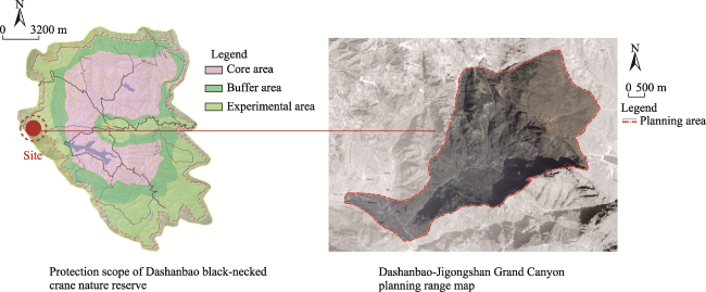
Fig. 2 Range of the Dashanbao mountainous outdoor tourism area |
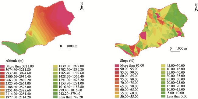
Fig. 3 Vertical height difference and slope chartNote: The slope is expressed as a percentage of the difference in elevation between the two points and their horizontal distance. |
Table 1 Overview of the major tourist attractions around Dashanbao Mountain |
| Area | Scenic spot name | Scenic spot level | Scenic area type | Main source of customers |
|---|---|---|---|---|
| South Sichuan tourism circle | Dinosaur Museum | 4A | Geological science popularization | Chengdu and southern Sichuan |
| Shunanzhuhai | 4A | Natural landscape | Chengdu, Chongqing and Yibin | |
| Buddha treasure ancient town | — | Ancient town ancient street | Luzhou and southern Sichuan | |
| Renaissance stone sea | 4A | Geological landscape | Chengdu, Chongqing and southern Sichuan | |
| Central Yunnan tourism circle | Duoyi River | 3A | Natural landscape | Kunming, Qujing |
| Hoodoos; stone forest | 5A | Geological landscape | Nationwide | |
| Northwest Guizhou tourism circle | A hundred miles of cuckoo | 4A | Flower landscape | Nationwide |
| Zhijin caves | — | Geological cave | Guiyang and cuckoo diversion people from a 100 mile radius | |
| Weining grass sea | — | Wetland lake | Guiyang, northeast Guizhou | |
| Tourism in northeast Yunnan | The Dashanbao National Park | Alpine wetland | Yibin and the special scientific research crowd |
Fig. 4 Land use analysis |
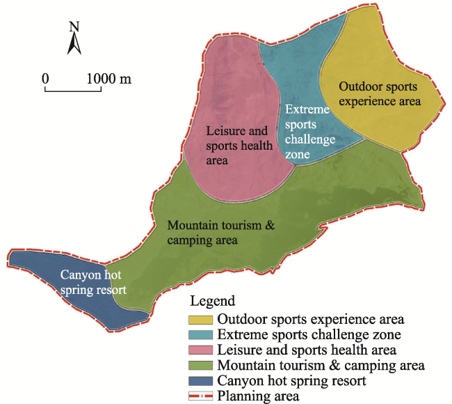
Fig. 5 Functional zones |
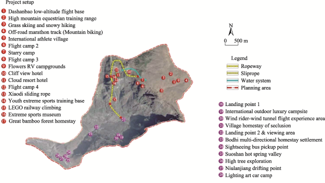
Table 2 Dashanbao Mountain outdoor tourism space optimization projects and their settings |
| Regional location | Space region | Project setting | Core plate |
|---|---|---|---|
| Big cliff hole village | Top of the mountain | Dabao low-altitude flying base, High mountain equestrian training range, Grass sking and sonwy hiking (Mountain biking), Off-road marathon track, International | Outdoor sports experience area |
| Diving tower; diving platform | Half way on the side of big mountain | Flight camp 2, Starry camp, Flight camp3, Flowers RV campgrounds, Cliff View hotel | Extreme sports challenge zone Leisure and sports health area |
| Big old forest- big bamboo forest | Mouth of Luojiagou to the landing point | Cloud resort hotel, Flight camp 4, Xiaodi sliding rope, Youth extreme sports training base, LEGO railway climbing,Extreme sports museum, Great bamboo forest homestay | |
| Luojiagou | Mouth of Luojiagou to the landing point | Sightseeing bus pickup point, Wind rider-wind tunnel flighe experience area, Landing point1, International outdoor lixury campsite | Mountain tourism & camping area |
| Mountain sports and sightseeing area | Along the Niulanjiang | Suoshan hot spring valley, High tree exploration, Niulanjiang drifting point, Lighting art car camp, Village homestay of seclusion, Landing point2 & viewing area, Bodhi multi-directional homestay settlement | Canyon sports resort |
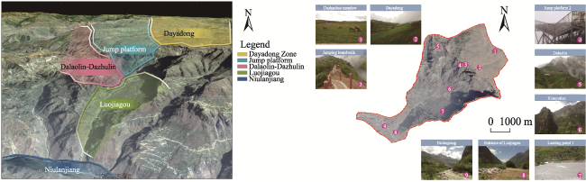
Fig. 6 The supporting facilities for the spatial zone projects |
| [1] |
|
| [2] |
|
| [3] |
|
| [4] |
|
| [5] |
|
| [6] |
|
| [7] |
|
| [8] |
|
| [9] |
|
| [10] |
|
| [11] |
|
| [12] |
|
| [13] |
|
| [14] |
|
| [15] |
|
| [16] |
|
| [17] |
|
| [18] |
|
| [19] |
|
| [20] |
|
| [21] |
|
| [22] |
|
| [23] |
|
| [24] |
|
| [25] |
|
| [26] |
|
| [27] |
|
| [28] |
|
| [29] |
|
/
| 〈 |
|
〉 |
