
Journal of Resources and Ecology >
Quantitative Analysis of Land Degradation in Mongolia from the Perspective of Geographical Zone
|
HAN Tengfei, E-mail: hantf@lreis.ac.cn |
Received date: 2023-12-22
Accepted date: 2024-03-20
Online published: 2024-10-09
Supported by
The National Natural Science Foundation of China(32161143025)
The Science & Technology Fundamental Resources Investigation Program of China(2022FY101905)
The National Key R&D Program of China(2022YFE0119200)
The Mongolian Foundation for Science and Technology(NSFC_2022/01)
The Mongolian Foundation for Science and Technology(CHN2022/276)
The Key R&D and Achievement Transformation Plan Project in Inner Mongolia Autonomous Region(2023KJHZ0027)
The Key Project of Innovation LREIS(KPI006)
The Construction Project of China Knowledge Center for Engineering Sciences and Technology(CKCEST-2023-1-5)
Natural and anthropogenic disturbances accelerate land degradation (LD) in arid, semi-arid, and dry sub-humid areas, leading to reduced land quality and productivity, loss of biodiversity, degradation of ecosystem services, and a decline in the quality of life of local people. To address this issue, the United Nations Convention to Combat Desertification (UNCCD) has set a target for LD neutrality (LDN). However, quantifying and comparing the status of LD at global or regional scales remains challenging due to the lack of coherent quantitative methods and tools. In this study, we focused on Mongolia, a region with significant LD problems, to examine patterns of LD and changes from 2015 to 2020, accounting for regional differences. Trends.Earth was used, as recommended by the UNCCD. The main findings are as follows: (1) Overall, the degraded land area in Mongolia accounted for 12.11% of the total land area, predominantly located in the southwest desert and desert steppe, gradually spreading to the northeast steppe. (2) The areas showing improvement in the land productivity index and degradation were 17.62% and 11.79%, respectively, with the most severely degraded areas concentrated in the southern desert and desert steppe regions. (3) The areas of improvement and degradation in the land cover index were 1.80% and 0.16%, respectively, with degraded areas scattered across regions of steppe, high mountains, and mountain taiga. (4) The areas of improvement and degradation in the land organic carbon index were 1.54% and 0.22%, respectively, with degradation primarily observed in adjacent areas of mountain taiga, steppe, and desert steppe. (5) The improved area (2.999×10⁵ km2) of LDN are more than the degraded area (1.895×10⁵ km2), indicating a positive trend toward LDN in Mongolia.
HAN Tengfei , WANG Juanle , HAN Baomin . Quantitative Analysis of Land Degradation in Mongolia from the Perspective of Geographical Zone[J]. Journal of Resources and Ecology, 2024 , 15(5) : 1185 -1192 . DOI: 10.5814/j.issn.1674-764x.2024.05.007
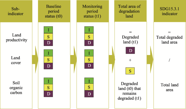
Fig. 1 Calculations steps for SDG 15.3.1 indicator |
Table 1 Data sets utilised in this study |
| SDG15.3.1 Sub-indictors | Data | Resolution | Data resource |
|---|---|---|---|
| Land productivity | MOD13Q1-coll6 | 250 m | LP DAAC-(usgs.gov) |
| Land cover | ESA-CCI | 300 m | www.esa-landcover-cci.org |
| Soil organic carbon | SoilGrids | 250 m | www.soilgrids.org |
Table 2 Relationship between land cover conversion types and land condition |
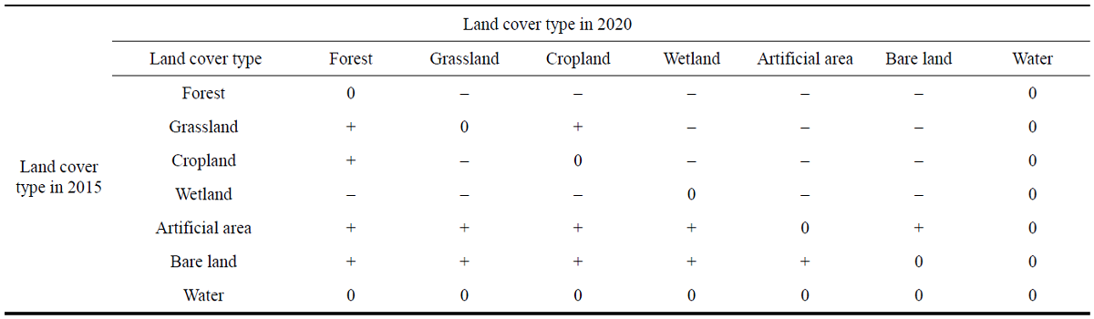 |
Fig. 2 Assessment of land productivity indicators (2015-2020) |
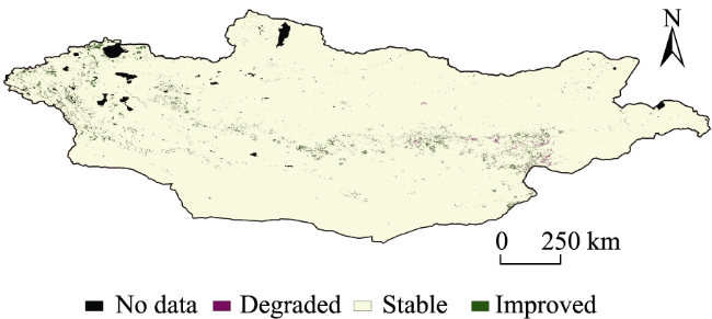
Fig. 3 Assessment of land cover indicators (2015-2020) |
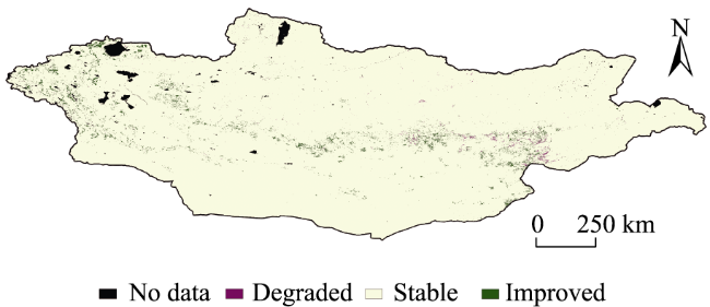
Fig. 4 Assessment of SOC indicators (2015-2020) |
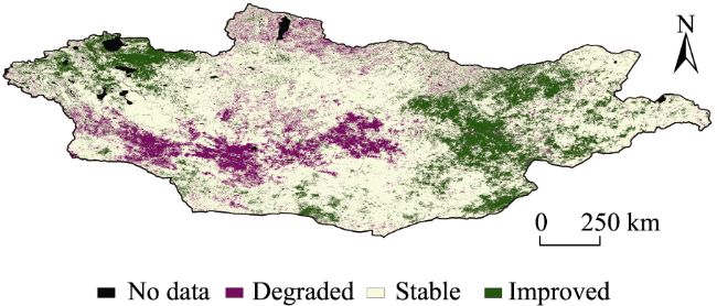
Fig. 5 Evaluation of LDN composite index (2015-2020) |
| [1] |
|
| [2] |
|
| [3] |
|
| [4] |
|
| [5] |
|
| [6] |
|
| [7] |
|
| [8] |
|
| [9] |
|
| [10] |
|
| [11] |
|
| [12] |
|
| [13] |
|
| [14] |
|
| [15] |
|
| [16] |
|
| [17] |
|
| [18] |
|
| [19] |
UNCCD. 1994. Elaboration of an international convention to combat desertification in countries experiencing serious drought and/or desertification, particularly in Africa. Paris, France: UNCCD.
|
| [20] |
|
| [21] |
|
| [22] |
|
| [23] |
|
| [24] |
|
| [25] |
|
| [26] |
|
| [27] |
|
| [28] |
|
/
| 〈 |
|
〉 |
