Special Column: Resources and Ecology of the Mongolian Plateau

Issues, Progress, and Recommendations in the Construction of Ecological Barrier on the Mongolian Plateau from the Perspective of Big Data

  • WANG Juanle , 1, 2, 3, * ,
  • LI Kai 1, 2 ,
  • XU Shuxing 1, 2 ,
  • SHAO Yating 1, 4 ,
  • WANG Meng 1, 2 ,
  • LI Menghan 1, 4 ,
  • ZHANG Yu 1, 4 ,
  • LIU Yaping 1, 4 ,
  • LI Fengjiao 1, 5 ,
  • Ochir ALTANSUKH 6 ,
  • Chuluun TOGTOKH 7
Expand
  • 1. State Key Laboratory of Resources and Environmental Information System, Institute of Geographic Sciences and Natural Resources Research, Chinese Academy of Sciences, Beijing 100101, China
  • 2. College of Resources and Environment, University of Chinese Academy of Sciences, Beijing 100049, China
  • 3. Jiangsu Center for Collaborative Innovation in Geographical Information Resource Development and Application, Nanjing 210023, China
  • 4. College of Geoscience and Surveying Engineering, China University of Mining & Technology (Beijing), Beijing 100083, China
  • 5. College of Geomatics, Xi’an University of Science and Technology, Xi’an 710054, China
  • 6. Environmental Engineering Laboratory, Department of Environment and Forest Engineering, National University of Mongolia, Ulaanbaatar 14201, Mongolia
  • 7. Institute for Sustainable Development, National University of Mongolia, Ulaanbaatar 14201, Mongolia
* WANG Juanle, E-mail:

Received date: 2023-12-27

  Accepted date: 2024-03-20

  Online published: 2024-10-09

Supported by

The National Natural Science Foundation of China(32161143025)

The National Key R&D Program of China(2022YFE0119200)

The Science & Technology Fundamental Resources Investigation Program of China(2022FY101902)

The Mongolian Foundation for Science and Technology(NSFC_2022/01)

The Mongolian Foundation for Science and Technology(CHN2022/276)

The Key R&D and Achievement Transformation Plan Project in Inner Mongolia Autonomous Region(2023KJHZ0027)

The Key Project of Innovation LREIS(KPI006)

The Construction Project of China Knowledge Center for Engineering Sciences and Technology(CKCEST-2023-1-5)

Abstract

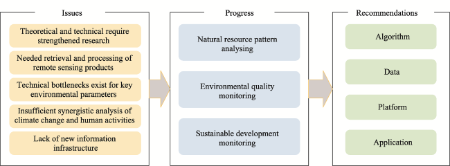
The Mongolian Plateau (MP), situated in the transitional zone between the Siberian taiga and the arid grasslands of Central Asia, plays a significant role as an Ecological Barrier (EB) with crucial implications for ecological and resource security in Northeast Asia. EB is a vast concept and a complex issue related to many aspects such as water, land, air, vegetation, animals, and people, et al. It is very difficult to understand the whole of EB without a comprehensive perspective, that traditional diverse studies cannot cover. Big data and artificial intelligence (AI) have enabled a shift in the research paradigm. Faced with these requirements, this study identified issues in the construction of EB on MP from a big data perspective. This includes the issues, progress, and future recommendations for EB construction-related studies using big data and AI. Current issues cover the status of theoretical studies, technical bottlenecks, and insufficient synergistic analyses related to EB construction. Research progress introduces advances in scientific research driven by big data in three key areas of MP: natural resources, the ecological environment, and sustainable development. For the future development of EB construction on MP, it is recommended to utilize big data and intelligent computing technologies, integrate extensive regional data resources, develop precise algorithms and automated tools, and construct a big data collaborative innovation platform. This study aims to call for more attention to big data and AI applications in EB studies, thereby supporting the achievement of sustainable development goals in the MP and enhancing the research paradigm transforming in the fields of resources and the environment.

Cite this article

WANG Juanle , LI Kai , XU Shuxing , SHAO Yating , WANG Meng , LI Menghan , ZHANG Yu , LIU Yaping , LI Fengjiao , Ochir ALTANSUKH , Chuluun TOGTOKH . Issues, Progress, and Recommendations in the Construction of Ecological Barrier on the Mongolian Plateau from the Perspective of Big Data[J]. Journal of Resources and Ecology, 2024 , 15(5) : 1113 -1124 . DOI: 10.5814/j.issn.1674-764x.2024.05.001

1 Introduction

“Ecological Barrier (EB)” refers to an ecosystem with specific protective functions. This term describes the characteristics of an ecosystem in a particular area whose structure and functions meet the ecological requirements for human survival and development. It also has a protective effect on surrounding regions by providing stable and continuous ecosystem services to surrounding and local areas. From 2021 to 2035, China will focus on the “Three Zones and Four Belts” as the core, and implement protection and restoration projects for crucial ecosystems. The “Three Zones” include the Qinghai-Tibet Plateau Ecological Barrier Zone, the Yellow River Key Ecological Zone, and the Yangtze River Key Ecological Zone. The “Four Belts” consist of the Northeast Forest Belt, the Northern Sand Control Belt, the Southern Hilly and Mountainous Belt, and the Coastal Belt. Among these ecological regions, the Northern Sand Control Belt serves as an important barrier in Northern China, involving cross-border areas with the Mongolian Plateau (MP), and has special ecological security significance.
The MP is situated in a transitional zone between the Siberian taiga and the arid grasslands of Asia. Traditionally defined geographically, the MP extends from the Greater Khingan Range in the east to the Altai Mountains in the west, with the Saihan and Yablonoi mountain ranges marking the northern boundary, and the Yin Mountains marking the southern boundary. It encompasses the entire territory of Mongolia and Inner Mongolia. The MP is a major arid and semi-arid region in the northern hemisphere and a focal point for climate change research. This plays a crucial role in the construction of ecological security barriers in northern China and the entire northern region of Asia.
In recent years, due to climate change and the intensification of human-environment relations, the ecological system has become severely imbalanced, attracting widespread attention domestically and internationally. The EB zone of the MP is not only crucial for the survival and development of the Chinese nation, but also significantly influences the civilization and geopolitical landscape of Asia. During the 2022 Shanghai Cooperation Organization (SCO) Summit, the leaders of China, Mongolia, and Russia expressed their commitment to extend the development plan for the China-Mongolia-Russia Economic Corridor for five years. During the 10th Anniversary Summit of the Belt and Road Initiative in 2023, the leaders of China and Mongolia jointly proposed implementing the United Nations Convention to Combat Desertification, actively participating in global desertification environmental governance, strengthening cooperation with neighboring countries, supporting desertification prevention and control in Belt and Road countries, leading policy dialogues, and sharing information to jointly address sand and dust storm disasters.
However, for historical reasons, this region has long been neglected and there is a serious lack of high-resolution and high-temporal scientific data. Although much research exists on diverse subjects, most studies have focused on the local level, or have focused with a coarse resolution at the large regional level. For example, scholars have expressed varied perspectives on and understanding of trends in land degradation and restoration in the MP (Li et al., 2019; Guo et al., 2021; Bai et al., 2023; Zheng et al., 2023). They also have different views on sandstorm development and attribution (Wu et al., 2022; Zhang et al., 2023). With the overall increase in the livestock and population in the MP, the continuous increase in grazing pressure in locally resource-rich areas has exacerbated the conflict between grassland ecosystems and the development of animal husbandry. Leveraging the dividends of the big data era and making full use of big data and Artificial Intelligence (AI) technologies to support the construction and sustainable development of EB on MP have become inevitable aspects of development.
Faced with these technological trends, this study identified issues in the construction of EB on MP from a big data perspective. This includes the issues, progress, and future recommendations for EB construction-related studies using big data and AI. These issues cover the current status of theoretical studies, technical bottlenecks, and the insufficient synergistic analyses of EB construction. Research progress introduces advancements in scientific research driven by big data in three key areas of MP: natural resources, ecological environment, and sustainable development. Recommendations for the development of big-data-driven studies in MP are proposed. The review framework is illustrated in Fig. 1.
Fig. 1 Review study framework

2 Issues in the EB construction on the MP

2.1 Theory and technology require strengthened research

Research on ecological services provides theoretical support for the construction of EB (Braat and de Groot, 2012; Wang et al., 2024). The MP is a typical ecologically vulnerable area, and conducting vulnerability analyses, ecological service function evaluations, and ecological carrying capacity accounting in this region is of great significance for the construction of the EB. The primary functions of grassland ecosystems include acting as windbreaks, sand fixation, soil conservation, water source conservation, climate regulation, and biodiversity protection (Fang et al., 2022). Ecological carrying capacity refers to the population size or economic scale that can be supported within a certain time and space under the premise that the ecosystem can resist disturbances and recover after disturbances (Gu, 2012; Zhang et al., 2022b). Cao et al. (2015), based on the assessment method of ecological carrying capacity using ecosystem services, evaluated the population size that can be supported by the direct consumption of ecosystem services by humans at a certain consumption level. Lane et al. (2014) selected key parameters representing land use and consumption characteristics such as food, freshwater, energy, habitat, climate, and environment to construct a carrying capacity assessment model for the Australian federal government and states. However, in the MP, there is a lack of capacity to conduct a real-time analysis of ecological vulnerability using intelligent computing and big data. Due to the lack of data-intensive computing support, the preparation and dynamic evaluation of annual data for ecological service functions have not been achieved. For pastoral production, there is a lack of public participation and handheld terminal computing tools for grass-animal balance assistance management.

2.2 Needed retrieval and processing of remote sensing products

Background data on natural resources and the environment are fundamental for various scientific research activities, including EB studies. Traditional scientific field investigations as part of resource and environmental studies are important for obtaining first-hand background data. Scientific field investigations involve significant human, financial, and time costs, and it is not possible to obtain data for large geographical regions, such as MP. For example, in the early 2010s, the project named “Integrated Scientific Expedition in North China and Its Neighboring Area”, covering the MP, Siberia, and the Far East of Russia, consisted of nine thematic investigations, including macro-scale Remote Sensing (RS), soil surveys, water resources investigations, water environment and aquatic biology investigations, lake surveys, forest and grassland ecosystem and nature reserve investigations, social and economic surveys, human living environment surveys, and aerosol and soil respiration fixed-point investigations. Data obtained through field scientific investigations are often limited to specific “points” or small-scale local areas, have certain limitations, and are restricted by costs related to manpower, finances, and time, making it difficult to establish continuous monitoring in the whole region. With the development of RS technology, particularly high-resolution RS data, and the extensive application of AI algorithms in the field of RS, the accuracy of RS information retrieval and extraction continues to improve. The refinement level of the RS inversion products for resource and environmental applications has gradually increased. The MP is a vast territory with strong regional differences. Organizing, obtaining, and producing key parameters for the ecological barriers of the MP from diverse sources of data requires massive imaging and computing resources. Therefore, it is necessary to have a high-precision RS product supply capability that is automated, integrates multiple data sources, and satisfies the needs of multi-scale applications.

2.3 Technical bottlenecks exist for key environmental parameters

In recent years, researchers have utilized satellite data with resolutions of 30 m, 10 m, and higher (e.g., Landsat, Sentinel 1/2, China’s GF1/2, SPOT, and QuickBird), and hyperspectral satellite data to extract high-precision thematic information related to land use/land cover and vegetation community characteristics. Various deep learning frameworks have been proposed by the research community, including TensorFlow, PyTorch, and Keras, providing foundational codes and models that significantly lower the barriers to applying and developing deep learning. Several key algorithms have been developed for various tasks, including FasterR-CNN/YOLO/RetinaNet for object recognition (Xu and Wu, 2020), U-Net/SegNet/DeepLab for image semantic segmentation (Qiu et al., 2023), and MaskR-CNN/SOLO for instance segmentation (Su et al., 2020). The integration of RS technology with ground measurements is crucial for obtaining key surface ecological and environmental parameters of the MP. Many scholars have utilized point-monitoring data to conduct resource and environmental element monitoring of the MP (Lamchin et al., 2016). However, these efforts have only yielded inversion results for local areas that lack machine learning and intelligent computing capabilities, thereby preventing the research outcomes from extending to larger geographic regions. In the aforementioned research, another key concern is that high-resolution and large area deep learning methods face challenges, such as difficulty in accurately establishing sample training libraries, long training time, and susceptibility to model overfitting.

2.4 Insufficient synergistic analysis of climate change and human activities

Under the combined impact of climate change and human activities, a warming climate, melting ice and snow, overgrazing, and inadequate grassland ecological protection over the past few decades have prevented desertification reversals in the MP. The livestock population in Mongolia has increased from 30.4 million in 2000 to 71.12 million in 2022 (https://www.1212.mn). Since its market-oriented transition in the 1990s, Mongolia has adopted a system of private livestock ownership by households, and public pasture ownership. This production method has evolved into a herder-dominated system of seasonal nomadism, rotational grazing, and camp-based grazing. Two-thirds of the herders have reduced the number of pastoral migrations, leading to a rapid increase in the number of livestock, reduced herd mobility, overgrazing near water sources and residential areas, and an imbalance in grass-animal spatiotemporal distribution in remote pastures. Overgrazing has been observed in the desert grasslands of the southwest and parts of the central and northern regions. In the Dayan region of western Mongolia, two-thirds of the monthly income of herders (approximately $310 USD) comes from animal husbandry, with 70% of the cash income deriving from the sale of cashmere, leading to a continuous increase in the number of goats (Lkhagvadorj et al., 2013). However, due to their grazing habits, goats cause more damage to pasturelands than sheep, and the unregulated increase in the population of goats has accelerated land degradation in the MP. Therefore, animal husbandry needs to be optimized. However, the potential of big data and intelligent computing technology for human activity and climate change regulation still needs to be explored, and end-to-end decision-making tools for sustainable grassland management in MP are lacking.

2.5 Lack of new information infrastructure

Driven by big data, the application of AI methods and cloud-computing technology can provide support for EB construction. E-science utilizes heterogeneous resources distributed across the Internet, including computing clusters, storage devices, and scientific instruments. By establishing a homogeneous environment, these resources can collaboratively serve users worldwide, enabling the sharing of computational resources across an entire wide-area network. Geoscience-related e-science research has undergone rapid development and application since the beginning of the 21st century. The Chinese Academy of Sciences has established an information platform for route selection and comprehensive management of geological surveys using PDA and web technologies (Zhu et al., 2011). By employing various network technologies, an integrated environment for hydro-ecological research in the Heihe River Basin has been developed that connects ecological-hydrological fixed-point monitoring systems and sensor networks to databases, model libraries, high-performance computing, and visualization environments (Li et al., 2023c). Informatization has been integrated into various disciplines under the impetus of Big Data, and resource science plays a crucial role in human life. Information technology can enhance the processing speed of big data, enabling rapid qualitative and quantitative resource analyses. However, the field of big data in resource science is still in its early stages, and there is a lack of collaborative platforms for EB studies in the MP.

3 Research progress on the construction of the ecological barrier in the Mongolian Plateau

In the MP, as the core region of the China-Mongolia-Russia Economic Corridor, research on regional resources and environmental ecology has attracted more attention. Fields related to EB construction include food consumption, land degradation, desertification, salinization, ecological fragility, sandstorms, carbon storage, animal husbandry, grass yield, poisonous weeds, and evapotranspiration, et al. This section selectively analyzes the progress of research in this area from the perspectives of natural resources, the ecological environment, and regional sustainable development, revealing advances made through the utilization of big data, including RS, surveys, and statistical methods.

3.1 Analysis of the natural resource pattern

3.1.1 Land cover

Land cover data comprehensively represent the elements covering the Earth's surface with temporal and spatial attributes. It typically includes various types, such as forests, grassland, water bodies, buildings, and barren land. The acquisition of land cover data provides fundamental scientific support for regional sustainable development, ecological environmental quality assessment, resource management, and assessing climate change. Global-scale publicly available land cover data are widely used; however, unique land cover types in the MP are lacking.
In the context of land cover situation in the MP, an object-oriented RS interpretation method was employed to establish rules and reference threshold ranges for land cover classification. High-resolution land cover data for Mongolia for 1990, 2000, 2010, and 2020 were obtained at a 30 m resolution. Based on the land cover conditions in Mongolia, an RS land cover classification system was established, comprising 11 categories: forest, meadow steppe, real steppe, desert steppe, barren, sand, desert, ice, water, cropland, and built area (Wang et al., 2022a). Subsequently, research on the sustainable development of MP was conducted using these data. The study found that over the past 30 years, the land cover change rate on the MP was 0.16%, but the trends varied for different land cover types and Sustainable Development Goals (SDGs) indicators. Cropland (SDG2) has shown a growth trend over the past five years, contrary to its initially significant decline. Water resources (SDG6) have noticeably declined, posing a significant threat to arid and semiarid regions. The building area (SDG11) continues to increase; however, the long-term upward trend has slowed in recent years. The forest area (SDG15) has decreased, but there has recovered in recent years (Zhang et al., 2022a). For EB construction studies, land cover data with higher temporal and spatial resolution should be developed for the MP.

3.1.2 Grassland resources

Grassland yield refers to the yield of plant biomass per unit area within a certain period, and is usually expressed in terms of mass or energy. This reflects the productivity level of the ecosystem in a region. In agricultural and pastoral production, rational management of grassland yield is crucial to ensure the stable development of animal husbandry and sustainable utilization of the ecological environment. Common methods for estimating the grassland yield include direct measurement, vegetation indices, comprehensive models, and deep learning. The direct measurement method involves direct sampling and weighing of fresh grass to obtain grassland yield data. Although this method provides high accuracy, it requires significant human and material resources and is unsuitable for large-scale grassland yield monitoring. Monitoring methods based on RS include vegetation indices, comprehensive models, and deep learning methods, depending on the model parameters. As an emerging method for grassland yield estimation, deep learning combines various influencing factors, adaptively learns and adapts to different grassland or pasture environments, and constructs accurate and robust grassland yield estimation models. Moreover, the model can gradually improve accuracy and stability with an increase in the data sample size, demonstrating good scalability.
Currently, model fitting based on RS data is the primary method used to estimate grassland productivity in the MP region. Gao et al. (2023a) studied the impact of vegetation productivity in Inner Mongolia from 1982 to 2015 using an NDVI3g dataset and meteorological data by applying a linear regression model. Lei et al. (2022) used meteorological station data and conducted sensitivity simulations based on a biome-BGC model to study the overall impact of droughts on grassland productivity in the Inner Mongolia over the past 50 years. Li et al. (2023b) utilized various machine learning algorithms combined with multi-source RS data, to estimate the grassland yield on the MP for nearly 22 years, analyzed the spatiotemporal characteristics of grassland yield, and obtained grassland yield data for 2000-2020.
Although research on grassland yield has made significant progress with the development of RS technology, various issues, such as the different mechanisms affecting grassland productivity in different regions, the complexity of vegetation types and structures, and the difficulty of ground field surveys, still need to be addressed. Given the vast area of the MP, there is a lack of sufficient on-site grassland surveys and long-term large-scale grassland yield data. In the future, establishing a comprehensive monitoring network and employing unmanned aerial vehicle (UAV) monitoring technology can help obtain more detailed vegetation and climate information, thereby enhancing the monitoring and estimation of grassland yield.

3.1.3 Water resources

The MP is home to water bodies, such as the Selenge River, Lake Hovsgol Nuur, and Hulun Lake. These rivers and lakes provide crucial freshwater resources for the region. They also play a significant role in supplying water to adjacent areas, such as northern China and the Baikal region in eastern Siberia. The water resources of MP are of paramount importance for livelihoods, economies, ecosystems, and sustainable development in the regions and surrounding areas. They play a key role in agriculture, animal husbandry, ecosystem health, energy production, cross-border cooperation, climate regulation, and tourism.
In surface water research, studies have been conducted in the Tuul River region of Mongolia and the cross-border region of Lake Baikal to address challenges such as difficulties in the water body classification of small rivers in Mongolia and the deployment of deep learning models. This study proposed a high-precision Pixel-based CNN water classification model (Li et al., 2021) and integrates it with the Google Earth Engine interface for the online deployment of deep learning models for surface water extraction research in the Lake Baikal Basin and MP (Li et al., 2022). The surface water area of the MP showed a decreasing trend from northwest to southeast, with water scarcity in the central and southern parts of Mongolia. Gao et al. (2023b) combined GRACE satellite data to monitor the water storage in the MP from 1991 to 2021. This study found that the terrestrial water storage in the MP experienced a continuous decline before 2012, followed by a fluctuating rebound. The most significant recovery of terrestrial water storage occurred in the northern MP.
In 2022, Mongolia initiated a nationwide movement to plant one billion trees by 2030, aligning with its commitment to the SDGs and addressing issues such as desertification, deforestation, and food insecurity. However, the distribution of surface water in Mongolia, particularly in the MP, is highly uneven. Therefore, conducting research on underground water resources in the MP, determining reasonable planting areas, and ensuring the success of tree-planting efforts will maximize the societal, economic, and ecological benefits.

3.2 Environmental quality monitoring

3.2.1 Desertification

Desertification refers to the degradation of land in arid, semi-arid, and subhumid dry areas caused by various factors, including climatic variations and human activities. This can lead to reduced biodiversity, declining soil fertility, dust storms, food shortages, poverty, and threats to human health. In 2015, the United Nations General Assembly included combating desertification (SDG15.3) as one of the 17 SDGs in the “2030 Agenda for Sustainable Development”. It aims to “combat desertification, restore degraded land and soil, including land affected by desertification, drought, and floods, and strive to achieve a land-degradation-neutral world by 2030”. The MP is a key area of global desertification research, and land degradation was the dominant trend in Mongolia from 1990 to 2015 (Wang et al., 2020). The region faces the increasing challenges of grassland degradation and soil desertification owing to the combined impact of climate change and human activities, such as overgrazing and unregulated mining (Guo et al., 2021).
RS technology is currently the primary means of monitoring desertification (Xu et al., 2023). Visual interpretation has the highest accuracy, but is time-consuming, labor-intensive, and subject to significant human subjectivity. Traditional supervised and unsupervised methods, such as automatic image classification methods, save considerable time and labor costs. Unsupervised classification is not affected by human interference, and automatically forms clusters with unique spectral characteristics. However, matching these clusters to the actual desertification categories is challenging. Traditional supervised classification still requires manual selection of training samples, resulting in higher accuracy; however, the selection of training samples is influenced by subjective factors. It is also challenging to distinguish between “same spectrum different objects” and “same object different spectrum” images, leading to misclassification or omission. Desertification index methods are flexible and convenient and are primarily based on vegetation indicators combined with surface reflectance and surface temperature for desertification identification (Meng et al., 2021; Xu et al., 2023; Zhao et al., 2023). However, crucial soil indicators representing the degree of desertification, such as soil organic matter, soil moisture, and soil layer thickness, are difficult to obtain using high-resolution soil spatial distribution data, which limits their application to large-scale, high-precision desertification information extraction.
With the development of AI technology in RS, machine and deep learning algorithms have been applied to large- scale desertification monitoring (Fan et al., 2020; Meng et al., 2021). However, desertification involves complex processes, and the selection of feature indicators and machine learning algorithms largely determines the accuracy of desertification monitoring results, particularly in situations with significant geographical and environmental differences. Therefore, for precise large-scale regional extraction of desertification information, it is essential to comprehensively evaluate the performance of various desertification feature indicators and machine learning algorithms to optimize the combination of feature indicators and machine learning to improve the accuracy of desertification monitoring.

3.2.2 Sand and dust storms

The MP is characterized by prevailing northwesterly winds, inferior vegetation cover, and frequent occurrences of droughts, floods, and freezing snow disasters, especially sand and dust storms. Approximately half of Mongolia experiences more than 20 days of sandstorms annually, and the southern regions bordering China are the most severely affected. Due to climate change and human activities, such as grazing, by 2016, approximately 72% of Mongolia’s land had experienced varying degrees of desertification. The numerous sandstorms in the spring of 2021 directly impacted the ecological environment of China and surrounding countries in northeast Asia. The MP is a major source of sandstorms in Asia, with a close relationship between sandstorms occurring in western China’s Alashan Plateau, Mongolia’s Gobi region, and western Inner Mongolia.
There are two main methods of obtaining sandstorm information: traditional ground meteorological observations and RS monitoring. Traditional ground observation stations have the advantage of having a long time series of observations, but there are challenges in acquiring and sharing data, especially in remote areas such as the southern Gobi region of Mongolia, making research difficult. RS methods can address this issue (Zhang et al., 2023), with data sources including MODIS, the Fengyun satellite, and Himawari-8 satellite data. MODIS data, in particular, are suitable for long-term series studies of the MP because of their advantages, such as a wide range of spectral bands, high data update frequency, large data volume, and long mission duration (Qian et al., 2022; Wang et al., 2022b).
To meet various future needs, it is essential to strengthen the combination of RS and ground meteorological station monitoring, increase the spatiotemporal analysis of dust concentrations, and focus on the spatiotemporal characteristics of severe dust distributions. By combining dust concentration analyses, a more in-depth study of the movement patterns of dust paths can be conducted to achieve the real-time dynamic monitoring of sandstorms. In terms of methods, considering the large spatial and temporal scales of MP, it is advisable to integrate technologies such as machine learning to achieve more accurate and rapid extraction of sandstorm information, thereby improving the efficiency of sandstorm monitoring. Future applications should involve collaboration with relevant sandstorm monitoring institutions to promote local prevention and control of sandstorm disasters. Additionally, strengthening international cooperation between China and Mongolia is crucial to jointly prevent sandstorm disasters in the MP, reduce losses, and promote sustainable development in the region.

3.2.3 Permafrost degradation

Over the past few decades, climate warming and human activities have led to various permafrost degradation issues in the MP, including increased soil temperatures, thickened active layers, southward migration of the permafrost boundary, and surface deformation. Owing to climate warming, the MP has experienced a continuous rise in temperature, a decrease in the ground freezing index, an increase in the ground thawing index, and a northward shift of the tree line, resulting in permafrost degradation. Furthermore, selective logging and forest fires caused by humans in the MP have led to reduce permafrost depth. Engineering construction in permafrost regions can disrupt vegetation and soil, causing an increase in ground temperature, deepening of the active layer, and increasing groundwater levels within the construction area, leading to phenomena such as frost-heaving mounds, ice columns, and ice thawing. Permafrost-related secondary geological hazards, including frost heaving, thaw settlement, and frost-heaving mounds, threaten pipeline safety in MP, while heat-related hazards are associated with pipeline construction and operation (Chen et al., 2018).
Progress in permafrost degradation monitoring can be summarized in terms of three stages. Initially, during permafrost distribution monitoring, researchers used limited permafrost exploration data and an understanding of the meteorological and topographic conditions that influence permafrost formation and development. In the second stage, with technological advancements, the RS technology has been applied to permafrost monitoring. In the early stages, visible light multi-spectral satellite sensors were used to monitor the permafrost. However, this sensor has long revisit periods and is easily affected by cloud cover, making it challenging to obtain information on the initiation and termination dates of permafrost active layer freeze-thaw cycles. In the third stage, with the rapid development of permafrost experience and physical models, the richness of RS indicators for establishing statistical models of permafrost distribution has increased. In particular, the use of surface temperature data products obtained through RS inversion has significantly improved the accuracy of spatial distribution monitoring and permafrost identification (Ran et al., 2018).
Compared to the permafrost regions in the Qinghai-Tibet Plateau and circum-Arctic regions, permafrost monitoring in the MP has not received widespread attention and lacks support from field measurements and RS data. In the future, a comprehensive “space-ground” monitoring technology network combining RS and ground-based measurements should be established to conduct research on permafrost regions on the MP. There should be a focus on developing long-term monitoring systems for cold region permafrost, utilizing meteorological stations to monitor the temperature, precipitation, surface temperature, snow depth, air pressure, wind speed, wind direction, and solar radiation in permafrost regions. In addition, geophysical exploration systems should be used to explore geological and stratigraphic information in permafrost regions. A combination of RS inversion, model simulation, drone aerial photography, and other methods should be employed to obtain information on environmental factors in permafrost regions.

3.3 Sustainable development monitoring

3.3.1 Livestock

According to the National Statistics Office of Mongolia, the total number of livestock in the MP was is expected to reach approximately 148 million by 2022. As one of the main regions for global grassland livestock production, an accurate understanding of the spatial distribution of livestock is crucial for maintaining ecological security in the MP. However, traditional livestock data are mainly collected in the form of statistical yearbooks based on administrative divisions, which do not provide detailed geographical information on livestock distribution. Consequently, livestock gridding technology has emerged. This technology extracts environmental factors, such as population, land use, and climate, from multiple data sources to construct spatial models related to livestock density. These models were used to infer the distribution of livestock over specific periods and spaces, thereby providing detailed information on the spatial distribution of livestock.
RS technology has become a significant tool for monitoring the spatial distribution of livestock at various scales. Multiple linear regression models and machine learning algorithms are commonly used to establish the relationships between livestock statistics and environmental factors to transform livestock statistical data from administrative units to grid scales (Li et al., 2023a). The Food and Agriculture Organization of the United Nations introduced the GLW project, which utilized multiple regression methods to link livestock density with simulation factors, and produced global livestock density distribution datasets for 2002 (GLW1) and 2006 (GLW2) (Robinson et al. 2007; Robinson et al., 2014). In recent years, with the advent of complex geographical computation techniques, geographic simulation methods represented by the random forest model have provided new approaches for addressing the geographical representation issues of livestock. Gilbert et al. (2018) combined environmental factors with random forests and obtained a global livestock distribution dataset (GLW3) with a spatial resolution of approximately 10 km, further improving the simulation accuracy.
Future research should explore effective model algorithms tailored to spatial studies of livestock in the MP. Detailed geographical distribution characteristics of livestock can be revealed by constructing spatial models. Additionally, modeling based on the regional characteristics of the MP can further enhance simulation accuracy, providing more refined data sources for relevant studies in the region. Combining diverse RS data with selected rich factors can optimize the model to reveal dynamic changes in livestock, and can serve as a fundamental basis for the sustainable development of grassland livestock farming in the MP.

3.3.2 Grassland ecosystem carbon pool

The terrestrial ecosystem carbon pool refers to the portion of carbon stored in different ecosystems during the carbon cycle, including aboveground biomass, belowground biomass, litter, and soil organic matter. Grasslands, the most extensive vegetation type in the MP, play a crucial role in global climate change and carbon cycling by sequestering atmospheric CO2 via photosynthesis. Grassland carbon pools mainly consist of vegetation biomass carbon pools and soil carbon matter pools, with the majority of carbon in grassland ecosystems stored in the soil because of the higher belowground biomass compared to the aboveground biomass.
In recent decades, researchers have estimated global grassland carbon pools and carbon sequestration capacities using methods such as ground biomass surveys, eddy covariance flux monitoring, atmospheric monitoring and inversion, and RS estimation models. In the MP, based on ground surveys in a typical grassland area in Inner Mongolia’s Xilin Gol, it was found that, owing to shrub invasion and grassland degradation, the soil carbon pool’s ability to sequester carbon decreased, weakening the grassland ecosystem’s carbon sequestration capacity in that region (Li et al., 2020). You et al. (2023) estimated the carbon flux in Inner Mongolian grasslands using eddy covariance observational data and the random forest method, revealing that Inner Mongolian grasslands are a weak carbon sink. Wang et al. (2023) established eddy covariance towers and observed that influenced by soil moisture, acted as carbon sinks, in Mongolia’s permafrost region, and as carbon sources in non-permafrost regions acted. Studies on the grassland carbon sequestration capacity of the MP using ground surveys and eddy covariance flux methods at a regional scale have provided relatively accurate results. However, studies based on RS estimation and atmospheric inversion have uncertainties in assessing grassland carbon sequestration capacity at a large regional scale (Xin et al., 2020).
Since 2000, much of the vegetation in the MP has been restored, thereby enhancing its carbon sequestration capacity (Yin et al., 2022). Nevertheless, under the dual impact of climate change and human activity, our understanding of the size, distribution, and driving factors of the carbon pool in MP grassland ecosystems is currently insufficient, and the results from different estimation methods exhibit considerable uncertainty. In the future, efforts should be made to strengthen the investigations and monitoring of grassland ecosystems on the MP by utilizing multi-source data and integrating various methods to accurately assess the carbon sequestration capacity of the grassland ecosystem, which has significant implications for the sustainable development of MP ecosystems.

3.3.3 Identification of ecologically vulnerable areas

Monitoring vulnerabilities and rebuilding degraded ecosystem functions are the main objectives of EB construction. Ecological functional zoning is the spatial division of ecological functions based on the physical environment of a region, ecosystem service functions, the need for ecological environment protection, and socioeconomic development (Fu et al., 2001). In the 21st century, research on ecological functional zoning has rapidly developed, covering scales from the national to the provincial, municipal, and county levels.
Commonly used paradigms for ecological regionalization that utilize expert-integrated methods demonstrate unique advantages for determining large-scale regional differentiation frameworks with precise spatial positioning. However, expert-integrated methods are constrained by prior knowledge, leading to strong subjectivity in determining issues such as zoning indicators and specific boundary trends. Moreover, significant differences exist between the different schemes (Luo et al., 2020). Following the rise of geostatistics in physical geography and a substantial increase in computing capabilities, mathematical methods and statistical techniques have gradually gained widespread attention in ecological regionalization research, including cluster regression analysis, discriminant analysis, and principal component analysis. In recent years, researchers have attempted to integrate new theories and intelligent big data processing techniques such as geographic information system analysis, artificial neural networks, and the fusion of multi-source geographic data (Zhen et al., 2017). Cui et al. (2021) focused on the Lake Dalinor Basin in the MP and divided the basin's ecological system region into extremely important sensitive areas, generally important sensitive areas, and low- importance sensitive areas, based on ecological characteristics and major ecological environmental issues in the basin.
Existing research on EB in the MP mostly involves ecosystem service functions and ecological functional zoning in small areas or a comprehensive study of a single ecological indicator, such as an overall study of desertification evolution. These methods rely largely on spatial statistical analyses. There is a pressing need for a large-scale comprehensive evaluation of ecosystem service functions and ecological functional zoning across the entire MP using intelligent and automated approaches. Existing intelligent ecological functional zoning algorithms require further optimization.

4 Recommendations for the development of the EB on the MP

4.1 Architecture of EB construction using big data

In line with the Belt and Road Initiative and the strategic development needs of “ecological security”, it is recommended that long-term data bottlenecks be overcome in the complex geographical system and human destiny community of the MP. Algorithmic model integration tools and autonomous and controllable computing environments should be provided to support cross-border regional collaboration. Additionally, it should offer user interaction services for multiple scales of scenarios, such as MP-gradient transect- herders, to ultimately produce various research outcomes, including algorithms, data, tools, and platforms. The overall architecture adopts a model-driven and data- driven approach, intelligent computing and network collaboration, multi-scale applications, and public terminal services. A technical roadmap is shown in Fig. 2.
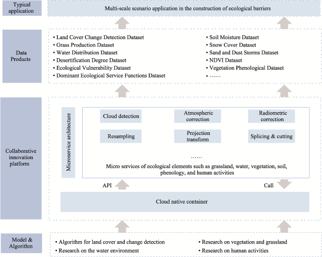
Fig. 2 Overall architecture of MP ecological barrier construction supported by AI and big data
Algorithmic aspects: To address the scarcity of basic and crucial resources and environmental parameter data in the MP, algorithms were established for the fine inversion of basic land cover/use, grass production, vegetation indices, plant phenology, surface water bodies, soil moisture, snow cover, desertification, and dust parameters. Automated data product toolkits should be developed to support algorithm integration for EB construction.
Data aspects: Intelligent computing services are provided to support the EB construction. An unified accessible channel for international and domestic data sources was established and the model algorithms were further integrated. Near-real-time monitoring of the relevant elements in the MP was realized, and multiple sets of long time series, medium-to-high-resolution basic and key resources, and environmental element products were acquired.
Platform aspects: Build a big data collaborative innovation platform for EB construction. Based on collaborative innovation and data sharing, integrate existing domestic and international RS data sources, and achieve cloud-based automated data processing and visualization. Full utilization of the collaborative innovation platform’s data and algorithm collection capabilities of collaborative innovation platforms can achieve cross-border collaboration, while providing an interactive platform for scientists from China, Mongolia, Russia, and other stakeholders.
Application aspects: Key vulnerable areas of EB are identified based on resources, environmental big data, and intelligent computing. Online analysis of ecological vulnerability is relevant at the MP scale, dynamic assessment of dominant ecosystem service functions at the transect scale, and calculation of grassland carrying capacity and assistance in grass-livestock balance management at the herder scale.

4.2 Key scientific issues to be addressed

(1) Large-scale data acquisition and processing
This research involves diverse sources of big data on complex spatiotemporal scales. Given the vast expanse of MP, the integration and coordination of these large-scale data resources are critical. Traditionally, scholars in various disciplines downloaded data locally for processing, facing challenges such as limited network bandwidth, storage resources, and unpredictable manpower costs. To address this issue, it is necessary to establish a comprehensive and computable data supply capacity for the MP by integrating various data sources through a cloud platform. This not only eliminates the need for local downloading of RS images, such as those from Chinese satellites, but also enhances the efficiency of RS image processing through online algorithm deployment.
(2) Deep learning sample acquisition
Owing to sparse sample availability, it is difficult to applying deep learning methods to improve the processing level and efficiency of various foundational resources and environmental information acquisition for the MP. To overcome this, we need to leverage extensive historical data integration and mining techniques and collect a rich sample library from diverse sources such as academic literature, field survey reports, historical databases, open datasets, and RS images. Utilizing a platform to expand the internal sample quantity for user reuse. Additionally, transfer learning methods are employed by training the main network of deep learning models using samples from similar regions with rich historical data and then fine-tuning the detailed network based on the constructed sample library to provide accurate label samples.
(3) Coordinating big data platforms
The EB construction of the MP involves diverse application requirements across dimensions, such as resources, environment, ecology, disasters, and sustainable development. It faces frequent coordination and invocation challenges regarding the model deployment and support for application scenario demonstrations. Moreover, geographical regions involve cross-border coordination between multiple countries, which requires scientists from different nations to collaborate and conduct joint research. To address this challenge, we recommend the use of a unified cloud-based big-data computing framework. This involves highly automated processes, such as model deployment, assembly, batch processing, and near-real-time computation, to provide collaborative support. Simultaneously, an interactive collaboration and sharing mechanism will be provided to scientists from China, Mongolia, Russia, and other nations to fully utilize the collaborative innovation platform’s data, model and algorithm aggregation capabilities.

5 Conclusions

The MP plays an important role as an EB in northern Asia. To address the fragile ecological regions in the MP under the influence of climate change and intensive human activity, attention must be paid to EB construction supported by big data and AI. This study first analyzes the current status of EB construction in the MP and then reviews the progress of big data usage for EB construction in the MP from the perspectives of natural resource management, environmental and ecological conservation, and regional sustainable development. Consequently, a series of recommendations are proposed, including future EB construction architectures and some key scientific issues to be addressed. This study is expected to focus attention on EB construction on the MP using big data and AI and to initiate a research paradigm shift in the area.
[1]
Bai Y, Li S G, Zhou J X, et al. 2023. Revisiting vegetation activity of Mongolian Plateau using multiple remote sensing datasets. Agricultural and Forest Meteorology, 341: 109649. DOI: 10.1016/j.agrformet.2023.109649.

[2]
Braat L C, de Groot R. 2012. The ecosystem services agenda: Bridging the worlds of natural science and economics, conservation and development, and public and private policy. Ecosystem Services, 1: 4-15.

[3]
Cao Z, Min Q W, Liu M C, et al. 2015. Ecosystem-service-based ecological carrying capacity: Concept, content, assessment model and application. Journal of Natural Resources, 30(1): 1-11. (in Chinese)

DOI

[4]
Chen S S, Zang S Y, Sun L. 2018. Permafrost degradation in Northeast China and its environmental effects: Present situation and prospect. Journal of Glaciology and Geocryology, 40(2): 298-306. (in Chinese)

DOI

[5]
Cui N, Yu E Y, Li S, et al. 2021. Protection measures of plateau lake based on ecosystem sensitivity and importance of ecosystem function: The case of Lake Dalinor Basin. Acta Ecologica Sinica, 41(3): 949-958. (in Chinese)

[6]
Fan Z, Li S, Fang H. 2020. Explicitly identifying the desertification change in CMREC area based on multisource remote data. Remote Sensing, 12(19): 3170. DOI: 10.3390/rs12193170.

[7]
Fang J Z, Xiong K N, Chi Y K, et al. 2022. Research advancement in grassland ecosystem vulnerability and ecological resilience and its inspiration for improving grassland ecosystem services in the karst desertification control. Plants-Basel, 11(10): 1290. DOI: 10.3390/plants11101290.

[8]
Fu B J, Liu G H, Chen L D, et al. 2001. Scheme of ecological regionalization in China. Acta Ecologica Sinica, 21(1): 1-6. (in Chinese)

[9]
Gao B, Ye X, Ding L, et al. 2023a. Water availability dominated vegetation productivity of Inner Mongolia grasslands from 1982 to 2015. Ecological Indicators, 151: 110291. DOI: 10.1016/j.ecolind.2023.110291.

[10]
Gao Z, Zhou Y, Cui Y, et al. 2023b. Rebound of surface and terrestrial water resources in Mongolian Plateau following sustained depletion. Ecological Indicators, 156: 111193. DOI: 10.1016/j.ecolind.2023.111193.

[11]
Gilbert M, Nicolas G, Cinardi G, et al. 2018. Global distribution data for cattle, buffaloes, horses, sheep, goats, pigs, chickens and ducks in 2010. Scientific Data, 5: 180227. DOI: 10.1038/sdata.2018.227.

[12]
Gu K. 2012. Concepts and assessment methods of ecological carrying capacity. Ecology and Environmental Sciences, 21: 389-396. (in Chinese)

[13]
Guo X, Chen R, Thomas D S G, et al. 2021. Divergent processes and trends of desertification in Inner Mongolia and Mongolia. Land Degradation & Development, 32: 3684-3697.

[14]
Lamchin M, Lee J Y, Lee W K, et al. 2016. Assessment of land cover change and desertification using remote sensing technology in a local region of Mongolia. Advances in Space Research, 57: 64-77.

[15]
Lane M, Dawes L, Grace P. 2014. The essential parameters of a resource-based carrying capacity assessment model: An Australian case study. Ecological Modelling, 272: 220-231.

[16]
Lei T, Wu J, Wang J, et al. 2022. The net influence of drought on grassland productivity over the past 50 years. Sustainability, 14: 12374. DOI: 10.3390/su141912374.

[17]
Li G, Wang J L, Wang Y J, et al. 2019. Estimation of grassland production in Central and Eastern Mongolia from 2006 to 2015 via remote sensing. Journal of Resources and Ecology, 10(6): 676-684.

DOI

[18]
Li K, Wang J, Cheng W, et al. 2022. Deep learning empowers the Google Earth Engine for automated water extraction in the Lake Baikal Basin. International Journal of Applied Earth Observation and Geoinformation, 112: 102928. DOI: 10.1016/j.jag.2022.102928.

[19]
Li K, Wang J, Yao J. 2021. Effectiveness of machine learning methods for water segmentation with ROI as the label: A case study of the Tuul River in Mongolia. International Journal of Applied Earth Observation and Geoinformation, 103: 102497. DOI: 10.1016/j.jag.2021.102497.

[20]
Li L H, Huang C C, Zhang Y L, et al. 2023a. Mapping the multi-temporal grazing intensity on the Qinghai-Tibet Plateau using geographically weighted random forest. Scientia Geographica Sinica, 43(3): 398-410. (in Chinese)

[21]
Li M, Wang J, Li K, et al. 2023b. Spatial-temporal pattern analysis of grassland yield in Mongolian Plateau based on artificial neural network. Remote Sensing, 15: 3968. DOI: 10.3390/rs15163968.

[22]
Li X, Liu S, Liu Q, et al. 2023c. Heihe remote sensing experiments: Retrospect and prospect. National Remote Sensing Bulletin, 27: 224-248. (in Chinese)

[23]
Li Z, Li X, Chen L, et al. 2020. Carbon flux and soil organic carbon content and density of different community types in a typical steppe ecoregion of Xilin Gol in Inner Mongolia, China. Journal of Arid Environments, 178: 104155. DOI: 10.1016/j.jaridenv.2020.104155.

[24]
Lkhagvadorj D, Hauck M, Dulamsuren C, et al. 2013. Pastoral nomadism in the forest-steppe of the Mongolian Altai under a changing economy and a warming climate. Journal of Arid Environments, 88: 82-89.

[25]
Luo Q, Zhen L, Yang W, et al. 2020. The influence of ecological restoration projects on cultural ecosystem services in the Xilin Gol Grassland. Journal of Natural Resources, 35(1): 119-129. (in Chinese)

DOI

[26]
Meng X, Gao X, Li S, et al. 2021. Monitoring desertification in Mongolia based on Landsat images and Google Earth Engine from 1990 to 2020. Ecological Indicators, 129: 107908. DOI: 10.1016/j.ecolind.2021.107908.

[27]
Qian W, Leung J C H, Ren J, et al. 2022. Anomaly based synoptic analysis and model prediction of six dust storms moving from Mongolia to Northern China in spring 2021. Journal of Geophysical Research: Atmospheres, 127: e2021JD036272. DOI: 10.1029/2021JD036272.

[28]
Qiu W Y, Gu L J, Gao F, et al. 2023. Building extraction from very high-resolution remote sensing images using Refine-UNet. IEEE Geoscience and Remote Sensing Letters, 20: 6002905. DOI: 10.1109/LGRS.2023.3243609.

[29]
Ran Y H, Li X, Cheng G D. 2018. Climate warming over the past half century has led to thermal degradation of permafrost on the Qinghai-Tibet Plateau. Cryosphere, 12: 595-608.

[30]
Robinson T P, Franceschini G, Wint W. 2007. The food and agriculture organization’s gridded livestock of the world. Veterinaria Italiana, 43: 745-751.

PMID

[31]
Robinson T P, Wint G R, Conchedda G, et al. 2014. Mapping the global distribution of livestock. Plos One, 9: e96084. DOI: 10.1371/journal.pone.0096084.

[32]
Su H, Wei S J, Liu S, et al. 2020. HQ-ISNet: High-quality instance segmentation for remote sensing imagery. Remote Sensing, 12(6): 989. DOI: 10.3390/rs12060989.

[33]
Wang J, Wei H, Cheng K, et al. 2020. Spatio-temporal pattern of land degradation from 1990 to 2015 in Mongolia. Environmental Development, 34: 100497. DOI: 10.1016/j.envdev.2020.100497.

[34]
Wang J L, Wei H S, Cheng K, et al. 2022a. Updatable dataset revealing decade changes in land cover types in Mongolia. Geoscience Data Journal, 9: 341-354.

[35]
Wang J N, Wu W J, Yang M, et al. 2024. Exploring the complex trade-offs and synergies of global ecosystem services. Environmental Science and Ecotechnology, 21: 100391. DOI: 10.1016/j.ese.2024.100391.

[36]
Wang N, Chen J, Zhang Y Y, et al. 2022b. Multi-source remote sensing analysis of the first sand and dust weather in Northern China in 2021. China Environmental Science, 42(5): 2002-2014. (in Chinese)

[37]
Wang Q, Peng X, Watanabe M, et al. 2023. Carbon budget in permafrost and non-permafrost regions and its controlling factors in the grassland ecosystems of Mongolia. Global Ecology and Conservation, 41: e02373. DOI: 10.1016/j.gecco.2023.e02373.

[38]
Wu C L, Lin Z H, Shao Y P, et al. 2022. Drivers of recent decline in dust activity over East Asia. Nature Communications, 13. DOI: 10.1038/s41467-022-34823-3.

[39]
Xin X, Jin D, Ge Y, et al. 2020. Climate change dominated long-term soil carbon losses of Inner Mongolian grasslands. Global Biogeochemical Cycles, 34: e2020GB006559. DOI: 10.1029/2020GB006559.

[40]
Xu D Q, Wu Y Q. 2020. MRFF-YOLO: A multi-receptive fields fusion network for remote sensing target detection. Remote Sensing, 12(9): 3118. DOI: 10.3390/rs12193118.

[41]
Xu S, Wang J, Altansukh O, et al. 2023. Spatial-temporal pattern of desertification in the Selenge River Basin of Mongolia from 1990 to 2020. Frontiers in Environmental Science, 11. DOI: 10.3389/fenvs.2023.1125583.

[42]
Yin C H, Luo M, Meng F H, et al. 2022. The spatiotemporal variation and influencing factors of vegetation carbon and water use efficiency in the Mongolian Plateau. Chinese Journal of Ecology, 41(6): 1079-1089. (in Chinese)

DOI

[43]
You C, Wang Y, Tan X, et al. 2023. Inner Mongolia grasslands act as a weak regional carbon sink: A new estimation based on upscaling eddy covariance observations. Agricultural and Forest Meteorology, 342: 109719. DOI: 10.1016/j.agrformet.2023.109719.

[44]
Zhang Y, Wang J, Ochir A, et al. 2023. Dynamic evolution of spring sand and dust storms and cross-border response in Mongolian Plateau from 2000 to 2021. International Journal of Digital Earth, 16: 2341-2355.

[45]
Zhang Y, Wang J L, Wang Y, et al. 2022a. Land cover change analysis to assess sustainability of development in the Mongolian Plateau over 30 years. Sustainability, 14: 6129. DOI: 10.3390/su14106129.

[46]
Zhang Z, Hu B Q, Qiu H H. 2022b. Comprehensive evaluation of resource and environmental carrying capacity based on SDGs perspective and three-dimensional balance model. Ecological Indicators, 138. DOI: 10.1016/j.ecolind.2022.108788.

[47]
Zhao Y H, Yang S Y, Liu L, et al. 2023. Variations and driving mechanisms of desertification in the southeast section of the China-Mongolia-Russia Economic Zone. Science of the Total Environment, 887. DOI: 10.1016/j.scitotenv.2023.164004.

[48]
Zhen L, Yan H M, Hu Y F, et al. 2017. Overview of ecological restoration technologies and evaluation systems. Journal of Resources and Ecology, 8(4): 315-324.

DOI

[49]
Zheng X Y, Lu N, Zhang L. 2023. Taking land degradation neutrality from concept to practice: A case study of the Mongolian Plateau. Acta Ecologica Sinica, 43(23): 9925-9937. (in Chinese)

[50]
Zhu Y, Sun J, Song J, et al. 2011. E-geoscience research and practice—A case show of North Eastern Asia Joint Scientific Exploration and Cooperative Research Platform. Advances in Earth Science, 26(1): 66-74. (in Chinese)

Outlines

/