Urban-Rural Integration and Green Development

The Spatio-temporal Evolution and Influencing Factors Underlying the Development of Urban-rural Integration in the Counties of Hebei Province, China

  • LI Xuemei , * ,
  • LI Yamin ,
  • HUANG Lingxiang
Expand
  • School of Economics and Management, Tianjin Chengjian University, Tianjin 300384, China
*LI Xuemei, E-mail:

Received date: 2022-11-07

  Accepted date: 2023-05-30

  Online published: 2024-03-14

Supported by

The Tianjin Philosophy and Social Science Planning Project(TJGL22-007)

Abstract

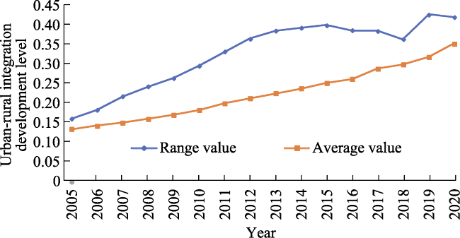
Urban-rural integration development is an important means of realising rural revitalisation, and agricultural and rural modernisation. We used the entropy method, kernel density analysis, the spatial exploratory data analysis method, and a geographic probe to analyse the spatio-temporal evolution characteristics of urban-rural integration and its influencing factors in Hebei Province from 2005 to 2020. We found: First, urban-rural integration in the province’s counties shows a fluctuating, albeit overall upward trend. In particular, 2005‒2010 exhibited a fluctuating trend, while 2011-2020 exhibited rapid improvement in urban-rural integration. Second, the urban-rural integration development shows some persistence, with faster-developing (slower-developing) areas continue developing faster (slower). Third, the influencing factors of the urban-rural integration level diversify and evolve over time, with the number of dominant factors gradually growing from one to relatively diversified.

Cite this article

LI Xuemei , LI Yamin , HUANG Lingxiang . The Spatio-temporal Evolution and Influencing Factors Underlying the Development of Urban-rural Integration in the Counties of Hebei Province, China[J]. Journal of Resources and Ecology, 2024 , 15(2) : 317 -328 . DOI: 10.5814/j.issn.1674-764x.2024.02.007

1 Introduction

Urban-rural areas comprise geographical systems that rely on each other to promote mutual integration. In particular, integrated urban-rural development is a new type of relationship between these areas which can be leveraged to effectively coordinate their development and build the new era. For a long time, China’s urban bias policy and the heavy industry system, which was implemented under the system of separate urban and rural areas, have posed serious challenges to the coordinated development of urban and rural areas as well as to common prosperity in the country. Consequently, China proposed the “integrated development of urban and rural areas” in 2002, “urban-rural integration” in 2012, “rural revitalisation and integrated development of urban and rural areas” in 2017, and finally, “urban-rural integration” in the report of the 19th National Congress. The aforementioned report proposed the establishment of a sound institutional mechanism and policy system for the integrated development of urban and rural areas (Shi et al., 2022). Together, these policies have played an important role in promoting the revitalisation of rural areas, and the deep integration of urban and rural areas in several aspects. For instance, China has made great achievements in urban-rural, ecological, spatial, and resident integration.
Yet, we still see the unbalanced and insufficient urban-rural development caused by the urban bias policy. Indeed, the Report to the 20th National Congress of the Communist Party of China further proposed to “comprehensively promote the revitalisation of the countryside. Adhere to the priority development of agriculture and rural areas, adhere to the integrated development of urban and rural areas, smooth the flow of urban and rural elements, and promote the revitalisation of rural industries, talents, culture and ecology, and organisations”. Insisting on the integrated development of urban and rural areas can be crucial for promoting coordinated regional development, and realising a regional economic layout that exhibits complementary advantages and high-quality development. However, building a harmonious and coexistent urban-rural relationship requires understanding the connotation of urban-rural integration, grasping its current status and nature of evolution, and implementing solutions according to local conditions.
Extant research on the development of urban-rural integration includes works combining the development history of the urban-rural relationship (Zhang et al., 2021b), exploring the theory and connotation behind urban-rural integration (Lin and Chen, 2005; Guo et al., 2020), and proposing the problems and practical paths of urban-rural integration (He et al., 2017; Cao et al., 2019). Empirical works examine the level of urban-rural integration (Zhang et al., 2020), urban-rural coupling analysis (Liu et al., 2021), and the influencing factors (He et al., 2017). The relevant research methods mainly include principal component analysis (Xie et al., 2020), the entropy method (Zhang et al., 2021a), the comprehensive index method (Xiu et al., 2004), and data envelopment analysis (Shi et al., 2021). Furthermore, studies are mainly focused at the provincial (Zhou et al., 2019) and municipal levels (Lu et al., 2021). The factors influencing urban-rural integration mainly include population flow (Chen and Lu, 2008), urban-rural factor mismatch (Liu and Lu, 2019), geographical factors (Cheng et al., 2020), and institutional research (Zhou and Song, 2014).
Notably, research typically focuses on urban-rural integration in provincial, municipal, and other region types, with few studies focusing on counties. The “Opinions on Comprehensively Promoting Rural Revitalisation and Accelerate the Modernization of Agriculture and Rural Areas” points out that the development of urban-rural integration in counties should be accelerated, and the coordinated development of large cities and small towns should be promoted. Further, the county should be taken as an important entry point for the development of urban-rural integration, the overall planning and high-level design should be improved, institutional shortcomings of urban-rural division should be broken, and development of equal exchanges and bidirectional flows of urban and rural factor elements should be accelerated.
Hebei Province can provide an interesting research setting for examining urban-rural integration. It is a slowly developing province involved in the process of Beijing-Tianjin-Hebei integration, which presents a complex urban-rural relationship among the urban ring area, those far from the city, and the highland and mountainous areas. Understanding the urban-rural relationship in Hebei Province can help in promoting the high-quality development of regional urban-rural integration.
This study uses data on 118 districts and counties in Hebei Province to construct a relatively systematic evaluation index system of urban-rural integration in the provincial counties, and then analyses the spatio-temporal evolution characteristics of integration and its underlying factors from 2005 to 2020. We use the entropy method, kernel density analysis, and spatial exploratory data analysis (ESDA) method for our analysis. In addition, we explore the development of integration with the help of geographic probes..

2 Study area

Hebei Province is located in the heart of Bohai Bay, surrounded by Beijing and adjacent to Tianjin. Hebei Province presents a complex urban-rural relationship between the urban ring, distant urban areas, and highland and mountainous areas. Understanding the urban-rural relationship in the province can provide guidance for the high-quality development of regional urban-rural integration.
Hebei Province includes 11 cities, such as Zhangjiakou, Chengde, and Baoding, with 167 county-level administrative units under their jurisdiction. Among them, 118 are counties and county-level cities. This study focuses on these 118 county-level administrative units (Fig. 1).
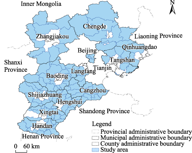
Fig. 1 Location of the study area

3 Data source and the research methods

3.1 Data source

The research period ranges from 2005 to 2020. The original data are taken from the EPS database (2005-2020), Hebei Economic Yearbook (2005-2020), Statistical Yearbook for counties (2005-2020), and Statistical Report on National Economic and Social Development of each city (2005-2020).

3.2 Research methods

First, we establish the index system of the urban-rural integration level in the counties of Hebei Province, standardise the data, and use the entropy method to measure the integration level. Then, we use the natural breaks method to visualize the urban-rural integration level with the help of ArcGIS 10.2 software. Second, we use the kernel density estimation method to explore the dynamic change in the urban-rural integration level in the counties with the help of stata 15.0 software. After that, GeoDa 1.18 software is used to conduct spatial autocorrelation analysis to explore the spatial distribution of the study area and interactions among counties. Finally, GeoDetector is used to analyse the factors influencing the level of urban-rural integration.

3.2.1 Indicator selection

Currently, research on the measurement of the county urban-rural integration level has not yet reached a unified standard. We construct our measure of integration by first considering the requirements concerning the “integration of infrastructure construction, modernisation of agriculture and rural areas, and rationalisation of factor allocation” mentioned in the 20th National Congress. Further, we follow the principles of data accessibility, objectivity, representativeness, and operability, and then combine the processes and experiences of scholars regarding the construction of the index system. This results in a three-criteria level index system containing 14 specific indicators.
We describe out indicators in the evaluation index system (Table 1) below:
Table 1 Indicator system and weights
Target Factor Indicators Calculation or description of indicators Indicator
properties
Weights
Urban-rural integration level Population
integration
Population density Total population/administrative area (persons km-2) - 0.0279
Rural employment structure Agricultural employment/nonfarm employment ratio (%) - 0.0138
Economic
integration
Per capita GDP Gross regional product/total population (yuan) + 0.1401
Share of nonagricultural industries Output value of secondary and tertiary industries/GDP (%) + 0.0206
Binary comparison factor Value added of secondary and tertiary industries/value added of primary industries (%) - 0.0096
Food production per capita Total food production/total population (kg person-1) + 0.0586
Level of agricultural modernisation Total power of agricultural machinery/crop sown area (kW ha-1) + 0.0846
Social
integration
Healthcare coverage for urban and rural residents The number of beds per 10000 people in urban and rural areas (number) + 0.0823
Basic education guarantee for urban and rural residents Number of teachers per 10000 people in urban and rural areas (person) + 0.0397
Farmers’ living standard Per capita disposable income of farmers (yuan) + 0.1314
Resident consumption level Total retail sales of social goods/total population (yuan person-1) + 0.1495
Wealth status of residents Urban and rural residential savings deposit balance + 0.1823
Road network density Road mileage/administrative area (km km-2) + 0.0564
Fertiliser load Fertiliser application/crop sown area (t ha-1) - 0.0032
(1) The exchange and concentration of factors in the process of social development inevitably results in population concentration and industrial structure adjustment. The development of each county should be coordinated with the current economic and social conditions to gradually establish a high level of urban-rural integration and realise rural revitalisation. The process of urban-rural integration promotes population agglomeration among cities and the spread of cities into their surrounding areas. We choose population density and rural employment structure to characterise factor agglomeration, and thus, measure the level of population integration.
(2) The essence of urban-rural integration development is that cities drive rural development, and industry promotes agriculture, thus driving rural development. In other words, rural development is mainly driven by improving the efficiency of agricultural output, enhancing the level of agricultural modernisation, and adjusting the industrial structure. We select per capita GDP, the share of non-agricultural industries, the binary comparison factor, food production per capita, and the level of agricultural modernisation as factors for measuring the level of economic integration. Per capita GDP is used to characterise the level of local economic development. The proportion of non-agricultural industries is used to characterise the gap between the status quo of local industrial output value. The binary comparison coefficient is used to characterise the level of synchronous development of the local industries. In the process of urban-rural integration and development, urban areas help drive the development the countryside by improving the level of modernisation of agriculture. Thus, it is necessary to use the average per capita food production and level of agricultural modernisation as measures of the status quo of rural development and level of economic integration.
(3) The ease of daily travel, the quality of life, medical care, education, and the quality of the living environment of urban and rural residents reflect the level of equalisation of infrastructure facilities between urban and rural areas. Therefore, healthcare coverage for urban and rural residents, basic education guarantees for urban and rural residents, farmers’ living standards, residents’ consumption levels, road network densities, and chemical fertiliser loads are used to measure the level of social integration. Urban-rural integration promotes the rationalisation and equalisation of factor allocation. Urban-rural residents’ health care security is used to characterise the urban-rural health care disparities. Urban-rural residents’ basic education security is used to characterise the education disparities. Farmers’ living standards and residents’ consumption levels are used to characterise urban-rural residents’ living standards from the perspective of both income and consumption. Road network density is used to characterise accessibility to transportation. Finally, fertiliser loading is used to characterise the ecological level of the local soil.

3.2.2 Measurement of urban-rural integration level

The entropy method is used objective weighting method for determining the weight of indicators according to the size of the information provided by the observed values of each indicator of the urban-rural integration level in Hebei Province.

3.2.3 Kernel density estimation

Kernel density estimation is a method used to estimate the probability density function of continuous random variables, which can effectively avoid the difference between the actual and observed values that arises from the predetermined functional form. It is used to study the distribution characteristics of the urban-rural integration level from the panel data itself (Zang and Su, 2019). Assuming that the probability function of the urban-rural integration development composite index x is f(x), its probability density function f(x) can be represented as follows:
f x = 1 N h i = 1 n k x X i h
where N denotes the number of observations, h is the bandwidth, k x X i h is denoted as a kernel function, x denotes a random variable, and X i denotes independently and identically distributed observations.

3.2.4 Spatial exploratory data analysis approach

ESDA is a method used to explore and visualise the spatial distribution patterns of elements. Here, the spatial correlation Moran’s I index of global spatial autocorrelation and local spatial autocorrelation index in ESDA are used to analyse the spatial correlation and agglomeration characteristics of the global and local areas of urban-rural integration in Hebei Province counties.

3.2.5 Geodetector

Geodetector is a tool used for analysing and exploiting spatial differentiation and the drivers behind an element, and can be modelled as follows:
q=1- 1 N σ 2 h = 1 l N h σ h 2
where q is the influence detection value of the influence factor on the level of urban-rural integration in Hebei Province counties, h is the stratification of the variable or factor, Nh is a district-wide stratification, l is the stratification number of the variable or factor, σ2 and σ2h are the variance of the whole region and stratification h, respectively. q takes values in the range of [0,1], where the closer q is to 1, the greater the driving effect of the influence factor on the level of urban-rural integration in Hebei Province counties.

4 Results

4.1 Changes in the level of urban-rural integration development in Hebei

The entropy method is used to calculate the level of urban-rural integration development of each county (Fig. 2). We find that: 1) The urban-rural integration development is progressing well, exhibiting a fluctuating albeit overall upward trend over the study period. In particular, 2005‒2010 exhibits fluctuations, while 2011‒2020 exhibits rapid development in the urban-rural integration level. This is due to the national implementation of new rural construction in 2005, urban-rural integration strategy instituted in 2012, and emphasis on the implementation of the urban-rural integration strategic deployment beginning in 2017. Under these policies, urban-rural integration in Hebei Province’s counties has continuously improved. 2) The difference in the level of urban-rural integration development among the 118 counties is large. The mean value is the highest in Qian’an City (0.4614), second highest in Sanhe City (0.3794), and lowest in Shangyi County (0.139). The difference between the scores of Sanhe City and Shangyi County is 0.3222. Qian’an City is located in the centre of the “Beijing, Tianjin, Tang, Qin, and Cheng” metropolitan area. Specifically, it is located 220 km from Beijing, 190 km from Tianjin, and 80 km from Tangshan, and is close to Qinhuangdao, Chengde, and Jingtang Port. The transportation network in Qian’an County is well developed and convenient for travel. This advantageous geographical location and convenient transportation have laid a solid foundation for the development of Qian’an City. Shangyi County is located in Zhangjiakou City in the northwestern part of Hebei Province at the southern edge of the Inner Mongolia Plateau at the junction of three provinces and six counties. Land resources are relatively abundant, but development is difficult, transportation is inconvenient, industrial transformation is difficult, and economic development is slow.
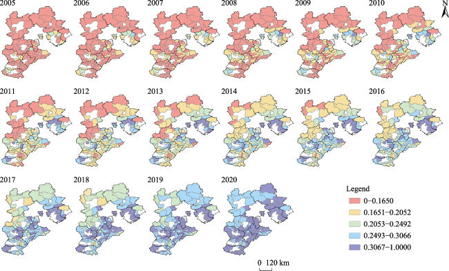
Fig. 2 Evolution of the urban-rural integration development level of the 118 counties in Hebei Province from 2005 to 2020
The evolution of urban-rural integration is not only a process of social development and continuous change but also a process of spatial reorganisation and integration. The unequal development of urban and rural areas in counties is the result of urban-rural factor circulation and the spatial structure evolution in counties. Hebei Province is undergoing the process of integrated development of Beijing-Tianjin- Hebei. It is a slow developing province, and exhibits a spatial structure positioned around and away from the capital. The balance between the mountainous areas and the coexisting, urban-rural integration development is uneven.
Counties are important carriers of urbanisation development. Hebei Province’s counties exhibit a large development gap. Analysing the development stage of urban-rural integration in each county, and understanding its attributes, structure, and functions and the linkage characteristics of the development of neighbouring counties is necessary to formulate differentiated policies for the promotion of the development of the urban-rural integration level of the area. Therefore, the mid-term evaluation results of the year 2012 were selected, and the natural breakpoint method was applied to divide the urban-rural integration development level of Hebei counties into five gradients. The division criteria were then extended to other years to draw a distribution map (Fig. 3). According to the classification results, the counties with urban-rural integration level scores between 0-0.1650, 0.1651-0.2052, 0.2053-0.2492, 0.2493-0.3066, and 0.3067-1.00 into the first to fifth stages, respectively. Among these stages, those in the fifth stage reflect a high level of urban-rural integration, indicating that the county’s factor exchange, economic development, industrial structure, geographic location, and ecological condition are all at high levels. In the fourth stage, a county’s urban-rural integration level is at a high level. During the third stage, a comprehensive judgement of a county’s various conditions is at a medium level. In the second stage, the county performs at a low level on each indicator. Finally, in the first stage, the county has the lowest performance.
Fig. 3 Urban-rural integration levels in the counties of Hebei Province
From 2005 to 2020, the level of urban-rural integration in Hebei Province fluctuated and rose, and the gap between the regional urban-rural integration levels decreased. However, the overall integration level was relatively low. In 2005, the level of urban-rural integration showed a spatial structure of “low, medium, and high” moving from west to east, with Yutian County, Zunhua City, Qianxi County, Qian’an City, and Leting County of Tangshan City, Huanghua City of Cangzhou City, Zhengding County, Xinle City, Jinzhou City, Xinji City, Zhao County of Shijiazhuang City, and Wu’an City of Handan City representing the areas with a high level of urban-rural integration development. The remaining counties represent the areas with a low level of development, with their urban-rural integration being in the first, second, and third stages.
The spatial aggregation effect of urban-rural integration development in Hebei Province is obvious. The regions with similar urban-rural integration levels show a contiguous distribution. Areas with a relatively low urban-rural integration level are concentrated in the northwestern part of Hebei Province, while those with a relatively high urban-rural integration level are concentrated in the central and eastern regions. The spatial distribution pattern changes from “low level, high gap” to “high level, low gap”.
Most counties with high levels of urban-rural integration are located in Tangshan City, Baoding City, and Shijiazhuang City, while most counties with low levels are located in Zhangjiakou City and Chengde City. This is because the former three cities have better economic base development. Baoding and Tangshan are close to Beijing and have certain geographical advantages, a smooth factor exchange, rapid development of the big three industries, and a relatively reasonable industrial structure. For example, Wu’an City, Qian’an County, and Qianxi County are rich in mineral resources, which helps drive the development of related industries. In turn, this greatly promotes the nonfarm employment of the agricultural population, improves the employment structure, and increases government revenue. Leting County, Luanan County, and Luanzhou City of Tangshan City form one of the major grain production bases in Hebei Province. Dingzhou City and Gaobeidian City of Baoding City, and the other counties adjacent to Langfang and Shijiazhuang, as well as Linzhang County of Handan City have better medical conditions and denser transportation road networks. Shijiazhuang, as the capital of Hebei Province, is the economic, cultural, scientific, technological, educational, and administrative centre of Hebei Province. Thus, it can take advantage of the provincial capital to gather talent, capital, and other factors. Furthermore, it has certain advantages in transportation, railway, and aviation. However, Shijiazhuang city has a low altitude, the industrial structure is biased towards high emission industries, and the air quality is poor. Zhangjiakou City and Chengde City have lower ratings as well. Zhangjiakou City is located in the northwestern part of Hebei Province, is surrounded by mountains, and has inconvenient transportation, a relatively weak infrastructure, less land resources that are difficult to develop, few non-agricultural enterprises, and a relatively good ecological environment. Chengde City is in the northeastern part of Hebei Province, with a low level of economic development and a suboptimal infrastructure; however, tourism, such as the Chengde Summer Resort, supports its development due to its better ecological condition.
China started implementing new rural construction in 2005 and an urban-rural integration strategy in 2012, and it emphasised the implementation of urban-rural integration strategic deployment in 2017. Along with the evolution of these policies, the level of urban-rural integration in Hebei Province counties increased between 2005 and 2020. Therefore, 2005, 2009, 2012, 2017 and 2020 are used as the representative years of urban-rural integration development levels in Hebei counties in the kernel density estimation to portray the temporal evolution characteristics of these levels across counties (Fig. 4).
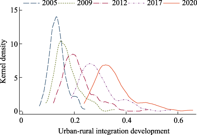
Fig. 4 Time-series dynamic evolutionary characteristics of the level of urban-rural integration development in Hebei counties
From the centre of gravity of the kernel density of the urban-rural integration level in Hebei Province counties, we can see a continuous right shift of the centre from 2005 to 2020. This indicates that the urban-rural integration level shows a rising changing trend.
The number and height of the peaks in the kernel density estimation graph show a single peak. This indicates that the level of urban-rural integration in Hebei Province counties does not exhibit polarisation. The peak height gradually decreases as one moves to the right. Further, the magnitude of the right shift continues to increase, indicating that there is a corresponding increase in the internal differences in urban-rural integration development in Hebei counties. It is difficult to reach a multiple equilibrium state over a long period of time, and the magnitude of the right shift continues to increase.
The kernel density estimation chart trailing shows an obvious trailing on the right side from 2005 to 2020. Further, the degree of this trailing gradually increases, indicating that the number of counties on the right side is more than the number of counties on the left side; that is, there are more cities with urban-rural integration development level values greater than the average during the study period, the proportion of counties in high-value areas increased during the study period, and the urban-rural integration development of Hebei counties in the study period shows a certain state of low-value locking.
The kernel density analysis reveals that, in general, the urban-rural integration development of Hebei counties reflects the dynamic evolutionary characteristics of fluctuating overall development levels, intercounty differences, and a degree of polarisation. Specifically, the overall urban-rural integration development level of counties in Hebei Province has rapidly grown, with counties with a higher level of urban-rural integration exhibiting more substantial growth and the between-county gap in the urban-rural integration level is narrowing.

4.2 Evolution of the spatiotemporal pattern of the level of urban-rural integration development in Hebei Province’ counties

Based on the level of urban-rural integration development of the 118 counties in Hebei Province calculated using the entropy value method, the spatial correlation of counties was analysed using GeoDa1.18 software according to the Moran index formula.
We find that the level of urban-rural integration among the counties is spatially correlated, with Moran’s I indices between 0 and 1. To further analyse the internal agglomeration in Hebei Province, this study uses GeoDa1.18 software to draw local Moran’s I scatterplots to analyse the local characteristics of urban-rural integration spatial agglomeration in 2005, 2009, 2012, 2017, and 2020 (Fig. 5).
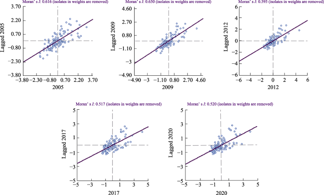
Fig. 5 Scatter plot of the urban-rural integration Moran’s I in 2005, 2009, 2012, 2017 and 2020

Note: The coordinate axis represent the spatial lag value.

The local spatial pattern is divided into four categories illustrated as four quadrants: 1) The first quadrant (HH) represents high levels of urban-rural integration in a particular region as well as its neighbouring districts and counties. The spatial agglomeration state is “high in the centre and surroundings.” 2) The second quadrant (LH) represents a low level of urban-rural integration in a particular region, but a high level of integration in its neighbouring regions. This exhibits the spatial agglomeration state of “low in the centre and high in the surrounding areas”. 3) The third quadrant (LL) represents low levels of urban-rural integration development in a particular region as well as its neighbouring districts and counties. This is the spatial agglomeration state of “low in the centre and surroundings.” 4) The fourth quadrant (HL) represents a relatively high level of urban-rural integration development in the region but a relatively low level in the neighbouring districts and counties. This exhibits a spatial agglomeration of “high in the centre and low in the surroundings” (Cao et al., 2019). As shown in Fig. 5, there is a certain degree of local spatial agglomeration in the development of urban-rural integration in Hebei Province at all stages. Two types of spatial differentiation, HH and LL, dominate the evolution of urban-rural integration development in the region. The overall level of urban-rural integration development is formed by the counties of Qianxi, Luanzhou, Changli, Luanan, Dazchang Hui Autonomous Region, and Xianghe, which are mainly con-centrated in Tangshan and Langfang. The overall level of urban-rural integration development forms a local spatialagglomeration characterised by high values (HH) mainly concentrated in Zhangjiakou City and Baoding City, and low values (LL) mainly concentrated in Zhangbei County, Guyuan County, Fengning Manchu Autonomous Region, Laiyuan County, Tang County, Shunping County, and other counties.
The scatter plots clearly show that the local spatial pattern of the urban-rural integration level of Hebei counties from 2005 to 2020 shows the characteristics of HH> LL>LH>HL. Most counties are located in the HH and LL quadrants. This means that when the urban-rural integration level of the region is high (low), the urban-rural integration level of its neighbouring areas is also relatively high (low). This may be because the regions in Hebei Province that are closer to Beijing and Tianjin, as well as the capital of Shijiazhuang and its neighbouring regions have a high level of urban-rural integration in terms of geographical location, and economic, social, spatial, and resource endowments. These endowment, population, and other factors are relatively smoothly exchanged among the regions, and transportation accessibility is high. Therefore, the urban-rural integration development of the relevant counties are correlated. Meanwhile, the number of districts and counties in the first (third) quadrant is gradually increasing (decreasing). This indicates that the spatial development pattern of urban-rural integration in Hebei Province counties gradually changes from a low- to high-level agglomeration state.

4.3 Influencing factors

To examine the influencing factors, we take the level of urban-rural integration in counties as the dependent variable, and the 14 indicators as independent variables. Since Hebei Province is a province containing both plains and mountains, topography has a great influence on traffic. Hence, traffic accessibility has an important influence on factor exchange and economic development. Therefore, topographic relief is added to the independent variables. Geographical detectors are used to identify the magnitude of influence of each factor. The larger the q-value is, the greater the influence, and vice versa.
GeoDetector is used for the analysis. Table 2 lists the degree of influence of each indicator on the development of urban-rural integration in Hebei Province in 2005, 2009, 2012, 2017, and 2020 (Table 2).
Table 2 Geographical detection results for the factors influencing urban-rural integration in Hebei Province’s counties
Factor Indicator 2005 2009 2012 2017 2020
Population
factors
Population density 0.458 0.417 0.409 0.374 0.348
Rural employment structure 0.618 0.610 0.612 0.512 0.449
Economic
factors
Per capita GDP 0.882 0.781 0.755 0.670 0.397
Share of non-agricultural industries 0.499 0.552 0.471 0.465 0.407
Binary comparison factor 0.476 0.561 0.458 0.488 0.381
Food production per capita 0.310 0.341 0.259 0.122 0.053
Level of agricultural modernisation 0.670 0.618 0.560 0.444 0.414
Social
factors
Healthcare coverage for urban and rural residents 0.193 0.292 0.197 0.068 0.102
Basic education guarantee for urban and rural residents 0.543 0.347 0.379 0.106 0.049
Farmers’ living standard 0.823 0.800 0.745 0.718 0.699
Resident consumption level 0.821 0.849 0.855 0.779 0.711
Wealth status of residents 0.687 0.673 0.676 0.702 0.705
Road network density 0.574 0.530 0.481 0.355 0.366
Fertiliser load 0.366 0.318 0.380 0.269 0.368
Natural
factors
Topographic relief 0.564 0.569 0.544 0.485 0.468
In 2005, the indicators with q-value exceeding 0.6 were per capita GDP (0.882), farmers’ living standard (0.823), resident consumption level (0.821), wealth status of residents (0.687), level of agricultural modernisation (0.670), and rural employment structure (0.618). In 2012, following 12 years of development, the indicators with q-values exceeding 0.5 included resident consumption level (0.855), per capita GDP (0.755), farmers’ living standard (0.745), wealth status of residents (0.676), and rural employment structure (0.612). By 2020, however, this had changed to resident consumption level (0.711), wealth status of residents (0.705), and farmers’ living standard (0.699). Thus, with time, the factors with stronger influence (q-value > 0.6) gradually decrease, while the difference in the influence values of each factor shows a fluctuating and decreasing trend. This indicates that the influence of these factors on the urban-rural integration level in Hebei Province counties gradually equalises. Rather than having a single dominant factor, we have a relatively diverse set of factors.
Next, we analyse the effects of individual categories of the population, economic, social, and natural factors. Specifically, we compute the mean values of the factors influencing the spatial and temporal differentiation of the first-level indicators from 2005 to 2020 (see Table 3).
Table 3 Mean values of the factors influencing the spatio-temporal variation of urban-rural integration development in Hebei province’s counties from 2005 to 2020
Year Population factors Economy factors Society factors Nature factors
2005 0.538 0.567 0.572 0.564
2009 0.514 0.571 0.544 0.569
2012 0.511 0.501 0.530 0.544
2017 0.443 0.438 0.428 0.485
2020 0.399 0.330 0.429 0.468
Notably, the influence of all factor categories shows a fluctuating and decreasing trend. Demographic and economic factors decrease more, reaching 0.139 and 0.237, respectively, while social factors and natural factors decrease less, only reaching 0.143 and 0.096, respectively. This may be because Hebei Province has a large population. The level of population urbanisation was low in the early stages. With economic development, it continued to drive industrial integration and factor agglomeration, thereby increasing population urbanisation. Further, Hebei Province has heavily invested in local transportation construction and public services in recent years, and the urban and rural economies have undergone development. Hence, the negative influence of transportation and public services on urban-rural integration in Hebei Province has been decreasing.
(1) Population factors. Population structure is one of the important points used to measure the degree of socioeconomic development and sustainable development. In particular, population density and occupational structure have a close connection with urban and rural development. At the early stage of its development, Hebei Province saw a large amount of rural labour flow into cities to promote urban industrialisation. This led to a shift in the structure of the rural labour force, resulting in the hollowing of agriculture and a lack of high-quality work groups in rural areas. The continuous optimisation of social factor allocation, balanced public services, an increasing level of basic education for urban and rural residents, and an increasing number of students receiving higher education in rural areas increased the return on rural education (Liu et al., 2020). Further, the labour force structure is constantly being reshaped, and the influence of demographic factors on urban-rural integration is decreasing.
(2) Economic factors. Economic factors are the most basic elements of urban-rural integration and development. Per capita GDP can reflect the level of economic development of a region. The share of non-agricultural industries, and binary comparison factor reflect the degree of development of the industrial structure between urban and rural areas. Meanwhile, the food production per capita and level of agricultural modernisation reflect the level of development of agricultural productivity and rural resource factor allocation as well as the vitality of rural development. Hebei Province is the main grain production base in the country. However, with industrial upgrading and transformation, industrial proliferation has accelerated the development of rural agricultural industrialisation. Concurrently, the modernisation level of non-agricultural industries, such as rural tourism (Zhang et al., 2016), agritourism, and sports (Wang et al., 2022), as well as traditional agricultural industries has been continuously improving. This has substantially increased farmers’ income and promoted rural economic development (He et al., 2022) while optimising the rural habitat. Thus, agriculture has entered the stage of industrialisation and modernisation characterised by low input and high return, and the level of integration of the three rural industries has been continuously improving.
(3) Social elements. The development of urban-rural integration is the coordinated development of an all-round system. This is reflected not only in the level of economic development of a particular region but also in the state of public welfare, such as education and medical care. Farmers’ living standard, residents’ consumption level, and the resident’s wealth status can directly reflect the living standard of urban and rural residents in the region. Further, the proportion of urban and rural residents with healthcare coverage and basic education can reflect the public service level of a region. The rising income of rural residents, their increasing affluence, and their increasing demand for a high standard of living have all contributed to the continuous improvement in rural habitats and infrastructures. Thus, the gap between urban and rural development, and that between the living standards of their residents have gradually narrowed, the degree of equality in basic public services in the areas has steadily increased, and urban and rural areas are gradually developing in a balanced manner.
(4) Natural factors. A basic premise of urban-rural integration development is the realisation of the efficient circulation and docking of various production factors in urban and rural economies, and throughout society. Road traffic is an important medium for the circulation of various factors and plays an extremely important role in urban-rural integration development. Hebei Province has mountainous and plains areas with complex terrain. Hence, topographic relief is an important factor affecting traffic accessibility. However, with the continuous development of science and technology, transportation facilities are constantly being improved to gradually overcome the inconvenience caused by terrain factors, and gradually promote the realisation of the urban-rural integration level.

5 Conclusions and recommendations

5.1 Conclusions

This study explores the spatio-temporal evolution characteristics and influencing factors of urban-rural integration development in Hebei Province’s counties during 2005- 2020 using the entropy method, spatial autocorrelation method, kernel density estimation, and geographic detector model. The following conclusions are drawn:
First, the level of urban-rural integration exhibits a fluctuating albeit overall upward trend. Thus, the gap between the regional urban-rural integration levels decreased, but the overall level still remained relatively low. The spatial evolution of the spatial structure is characterised by a shift from a “low-middle-high” structure to a “west-low-east-high” structure. Specifically, the spatial structure of “low, medium, and high” moving from west to east can be seen in 2005. Further, the counties’ urban-rural integration levels were in the first, second, and third stages. Meanwhile, in 2020, the integration levels exhibits a spatial structure of low in the west and high in the east. Further, integration levels are in the fourth and fifth stages.
Second, the urban-rural integration levels seem as if they are locked-in in high and low value regimes. From the viewpoint of spatial evolution, the high level of coordination of urban and rural integration in Hebei Province’s counties occurs in the districts and counties surrounding Beijing and Tianjin, as well as those surrounding the capital of Shijiazhuang and its adjacent areas. This evolution is driven by the radiation of the Beijing-Tianjin metropolis, which has a relatively comprehensive infrastructure and exhibits close cooperation between urban and rural areas, high economic and social development and urbanisation, and a significant spillover effect on the countryside. Within the county, the low-level coordination area remains in Zhangjiakou and Chengde cities. These two places are geographically far from the metropolis, the terrain is relatively complex, and transportation access is relatively low. Due to the metropolis, the radiation-driven role of the smaller urban and rural elements in the exchange of the low degree integration shows a certain high value and low value in the locking phenomenon.
Third, the factors influencing the level of urban-rural integration in Hebei Province gradually tend to evolve in a diversified manner. The main factors include per capita GDP, resident consumption level, wealth status of residents, farmers’ living standards, and share of non-agricultural industries. With the evolution of policies and social development, rather than having a single dominant influencing factor, we have a diverse set of influencing factors’. The influence of various factors on the level of urban-rural integration is gradually decreasing, while the influence of natural uncontrollable factors remains relatively prominent.

5.2 Recommendations

We propose the following recommendations for the promotion of integrated urban-rural development and narrowing the regional development gap in Hebei Province’s counties:
(1) The functional positioning of counties and their stimulating endogenous power need to be enhanced. For instance, by evaluating the current status of the urban-rural integration level of counties in Hebei Province, the stage of development of the region should be analysed and the functional positioning of the counties in Hebei Province should be clarified. Furthermore, the government should constantly adjust the industrial layout based on the geographic location, economic quality, resource endowment, ecological environment, and other conditions of the townships and villages in these counties. Counties can be viewed as the nodes that concentrate the key elements of rural population, industry, capital, and technology to support the synergistic development of industrial integration and rural residence. The regions in Hebei Province that are closer to Beijing and Tianjin, or the capital of Shijiazhuang and its adjacent regions, and relatively developed regions should actively undertake population and industry transfer from the big cities. In addition, they should improve their factor allocation, industrial structure optimisation, etc., to further promote the level of integration of urban and rural areas. The counties in the western part of the province should improve transportation and logistics in terms of both their depth and breadth. These are needed to encourage and guide social capital in various forms of investment in county infrastructure, major projects, and industrial development to promote the development of the county economy. Meanwhile, attention should be given to the relationship between emerging industries and traditional agriculture, relying on the good climate and development of the characteristics of the dominant industries in accordance with the principle of “one county, one product” to cultivate and build advantageous industries, promote rural areas, and foster the integration level of urban and rural areas. Furthermore, efforts should be made to constantly incorporate high-quality talent to enhance the endogenous power of rural development while promoting the development of the rural economy.
(2) The cooperation between government and enterprises should be strengthened to promote agricultural improvements. To effectively promote agricultural production, Hebei Province should establish the principle of “government guidance, social participation, and farmers’ main body.” It should promote the development of agricultural industries through regional financial institutions, technical support, geographic planning, policy support, human capital, and enterprise investment. To promote the development of agricultural industries with market advantages, special high-quality agriculture should be created, and the integration of agricultural industries should be promoted. The county low-value area is in the Zhangjiakou and Chengde area. It is first necessary to coordinate planning, strengthen infrastructure construction, improve transportation access, promote the modernisation of agriculture and rural areas via industrial development, and strengthen the use of industry to supplement agriculture and the use of the city to develop the countryside. Overall, the formation of a new type of industry-agriculture-rural-urban relationship should be promoted, where industry and agriculture are mutually reinforcing, and urban and rural areas complement each other and develop in a coordinated manner for mutual prosperity. Further, the integration of modern agriculture and tourism should be deepened by involving cultural and mountainous features. Next, efforts should be made to implement the county economy brand-driven strategy, strengthen scientific and technological innovation, seize the development opportunities brought about by the change in the traditional spatio-temporal development patterns under the wave of new scientific and technological revolution, leverage the new industries and modes emerging from new technologies, actively cultivate the county’s characteristic industries, and explore the county’s new digital economy modes, such as live broadcasting and OTT economy. Together, these actions can help promote the sustainable development of the county’s economy.
(3) The integrated development of Beijing, Tianjin, and Hebei should be actively promoted and coordinated to solve practical problems. We need to grasp the opportunities of this region’s coordinated development strategy, formulate cooperation plans, and strengthen the spillover effect of the region on the integrated development of urban and rural areas in Hebei Province. We further need to build a high- quality urbanisation system by adapting, advancing, and classifying development around Beijing and Tianjin. The construction of Hebei County by leveraging the platform provided by Beijing and Tianjin should be accelerated. Enterprises should be encouraged to move in, and the industrial structure should be constantly optimised. Finally, with the help of diverse types of project construction, the infrastructure and public services in the rural areas should be constantly improved, helping realise rural economic development and encourage skilled labour to return. Together, this will promote regional urban-rural integration development.
[1]
Cao Z, Li Y R, Chen Y F. 2019. Approaches to rural transformation and sustainable decelopment in the context of urban-rural integration. Acta Geographica Sinica, 74(12): 2560-2571. (in Chinese)

[2]
Chen Z, Lu M. 2008. From segmentation to integration: The political economy of urban-rural economic growth and social harmony. Economic Research Journal, 43(1): 21-32. (in Chinese)

[3]
Cheng M L, Li L N, Zhou Y. 2020. Exploring the urban-rural development differences and influencing factors in the Huang-Huai-Hai Plain of China. Journal of Geographical Sciences, 30(10): 1603-1616.

DOI

[4]
Guo H H, Liu X M, Liu L J. 2020. Regional disparities and dynamic evolution of urban-rural integration development in China. Inquiry into Economic Issues, 41(10): 1-14. (in Chinese)

[5]
He H, Wang S X, Tuo S H, et al. 2022. Analysis of the effect of rural tourism in promoting farmers’ income and its influencing factors-based on survey data from Hanzhong in southern Shaanxi. Sustainability, 14(3): 1289. DOI: 10.3390/su14031289.

[6]
He Y H, Zhou G H, Tang C L, et al. 2017. Theory of spatial organization of urban-rural integration in urban agglomeration areas. Geographical Research, 37(2): 241-252. (in Chinese)

[7]
Lin Y Y, Chen G S. 2005. FRP urban design integrating ecology: Concept, value, method and production. Journal of Southeast University (Natural Science Edition), 35(S1): 205-213. (in Chinese)

[8]
Liu C F, Li Y, Li S P. 2020. The returns to education in rural China: Some new estimates. Australian Journal of Agricultural and Resource Economics, 64(1): 189-208.

DOI

[9]
Liu H, Zhu T H, Xin L. 2021. Coupling coordination and the driving factors of agricultural modernization and urban-rural integration. Research of Agricultural Modernization, 42(6): 982-995. (in Chinese)

[10]
Liu M H, Lu F. 2019. Study on the influence of factor mismatch on urban-rural integration development-evidence from Chinese province panel data. Journal of Agrotechnical Economics, 286(2): 33-46. (in Chinese)

[11]
Lu Y C, Gao X H, Liu M. 2021. Efficiency leakage and time spatial differentiation of coupling and coordinated system of urban-rural development. Rural Economy, 461(3): 101-109. (in Chinese)

[12]
Shi J G, Duan K F, Wu G D. 2022. The measurement of the urban-rural integration development level of the Yangtze River Delta region and the analysis of its spatio-temporal characteristics. Journal of Tongji University (Social Science Edition), 33(1): 78-89. (in Chinese)

[13]
Shi J G, Duan K F, Wu G D, et al. 2021. Efficiency of urban-rural integration development in the Yangtze River Delta under the background of carbon emission constraint. Economic Geography, 41(6): 57-67. (in Chinese)

DOI

[14]
Wang Z, Jiang Y Y, Li X J, et al. 2022. Does ski tourism improve the regional economy? The case study of Chongli, China. Journal of Resources and Ecology, 13(4): 603-612.

DOI

[15]
Xie S H, Zhou F B, Wu T L, et al. 2020. Evaluation and spatial pattern evolution of urban and rural integration development in Yangtze River Delta. Urban Development Studies, 27(3): 28-32. (in Chinese)

[16]
Xiu C L, Xu D M, Zhu L X. 2004. Evaluation of urban-rural integration course in the northeast China. Scientia Geographica Sinica, 24(3): 320-325. (in Chinese)

[17]
Zang L Z, Su Y Q. 2019. Study on the spatial pattern and evolution trend of China’s new urbanization. Ecological Economy, 35(4): 81-85, 110. (in Chinese)

[18]
Zhang H P, He R W, Li L N, et al. 2021a. Spatial-temporal differentiation of urban-rural integration level and rural revitalization path in the capital region. Journal of Natural Resources, 36(10): 2652-2671. (in Chinese)

DOI

[19]
Zhang W B, Zhang Z B, Dong J H, et al. 2021b. Toward rural-urban co-governance: An interpretation of the change of rural-urban relationship since the Reform and Opening Up. Progress in Geography, 40(5): 883-896. (in Chinese)

[20]
Zhang X L, Qiu F D, Zhu C G. 2020. Evolution of urban-rural integration development level in Huaihai Economic Zone from the perspective of spatio-temporal interaction. Journal of Natural Resources, 35(8): 1867-1880. (in Chinese)

DOI

[21]
Zhang Y X, Min Q W, Jiao W J, et al. 2016. Values and conservation of Honghe Hani Rice Terraces System as a GLAHS site. Journal of Resources and Ecology, 7(3): 197-204.

DOI

[22]
Zhou J N, Qin F C, Li U J, et al. 2019. Measurement, spatial-temporal evolution and influencing mechanism of urban-rural integration level in China from a multidimensional perspective. China Population, Resources and Environment, 29(9): 166-176. (in Chinese)

[23]
Zhou K, Song L Q. 2014. A study on the dynamic mechanism of institutional change of urban-rural integration in China. Contemporary Economic Research, 232(12): 74-79. (in Chinese)

Outlines

/