Ecosystem and Ecosystem Services

Spatiotemporal Variation and Drivers of Drought based on TVDI in the Lower Reaches of the Jinsha River

  • CHEN Guojian , 1, 2 ,
  • FANG Ning , 1, 2, * ,
  • LI Jianfeng 1, 2 ,
  • WU Xinghua 3, 4 ,
  • DONG Xianyong 4, 5
Expand
  • 1. Shanghai Survey and Design Institute Company Co., Ltd, Shanghai 200335, China
  • 2. Yangtze Eco-Environment Engineering Research Center, China Three Gorges Corporation, Beijing 100038, China
  • 3. China Three Gorges Corporation, Wuhan 430010, China
  • 4. China Three Gorges Renewables (Group) Co., Ltd, Beijing 100053, China
  • 5. China Three Gorges Construction Engineering Corporation, Chengdu 610000, China
*FANG Ning, E-mail:

Received date: 2023-05-11

  Accepted date: 2023-07-28

  Online published: 2023-12-27

Supported by

The Research Project of China Three Gorges Corporation(202103325)

Abstract

The lower reaches of the Jinsha River is the main distribution area of hot-dry valleys in China. While it suffers from frequent droughts, the spatiotemporal variation and driving forces of drought in this area under climate change are still unclear. The spatiotemporal variations of Temperature Vegetation Drought Index (TVDI) and drivers of drought were explored using MODIS land surface temperature and NDVI data from 2000 to 2020. The results are fivefold. (1) TVDI was highly correlated with soil moisture content at a depth of 0-7 cm, indicating that it can accurately reflect the drought situation in the study area. (2) The spatial variability of TVDI was highly heterogeneous, with a multi-year average of 0.59, and the drought level was mainly between normal and dry. (3) From 2000 to 2020, TVDI showed a slightly increasing trend. It increased in 63% of the study area, and significantly increased in 21% of the study area. At the same time, the area at the dry level increased by 14.5% in 2020 from the normal level in 2000. (4) Slightly different from the standard phenomenon of “dry gets drier, wet gets wetter”, we found that both dry and wet areas were becoming drier. (5) TVDI was positively correlated with annual mean temperature in 86% of the region, of which 43% of the region showed a significant correlation. The increasing temperature was the main driving force for the increase in drought in the study area. Our results can provide new insights into the spatiotemporally heterogeneous response of drought to climate change in the lower reaches of the Jinsha River.

Cite this article

CHEN Guojian , FANG Ning , LI Jianfeng , WU Xinghua , DONG Xianyong . Spatiotemporal Variation and Drivers of Drought based on TVDI in the Lower Reaches of the Jinsha River[J]. Journal of Resources and Ecology, 2024 , 15(1) : 44 -54 . DOI: 10.5814/j.issn.1674-764x.2024.01.004

1 Introduction

Drought is a natural disaster that entails a persistent water shortage over a large area, and is characterized by a wide range of impacts, long duration, and high frequency of occurrence (Han et al., 2014; Lin et al., 2015). According to the IPCC Sixth Assessment Report, the global surface temperature in 2011-2020 was 1.09 ℃ higher than in 1850- 1900, and the increase in temperature is expected to reach 1.5 ℃ in the next 20 years (Pörtner et al., 2022). The continued intensification of global warming has exacerbated the occurrence of droughts, leading to an expansion of the world’s drought area (Piao et al., 2010; Huang et al., 2016; Huang et al., 2017b). The typical “dry gets drier, wet gets wetter” phenomenon under climate change has been proposed and documented by previous studies (Chou et al., 2013; Liu and Allan, 2013). Drought has become the most severe natural disaster in China, and it is a threat to socioeconomic development and ecosystem security. Drought areas account for more than 50% of the national territory, and this percentage increased by 8.3% from 1980 to 2015 (Li et al., 2021).
Drought monitoring is important for timely warning and the development of effective mitigation strategies. Traditional monitoring methods are based on meteorological data, such as the Palmer Drought Severity Index (Alley, 1984), the Standardized Precipitation Index (Mckee et al., 1993), and the Standardized Precipitation Evapotranspiration Index (Lopez-Moreno et al., 2013). Traditional drought indexes are accurate, but they are often limited by the number and distribution of monitoring stations. The small spatial coverage of each station makes it difficult to accurately reflect the spatial heterogeneity of droughts (Liang et al., 2014; Dai et al., 2023; Zhou et al., 2023). Remote sensing technology has been widely used in recent years due to its advantages of large spatial coverage, continuity, and convenience for large-scale and long-term drought monitoring (Rhee et al., 2010). Based on remote sensing data, several drought indexes have been developed for monitoring drought, such as the Normalized Difference Temperature Index (Mcvicar and Jupp, 1998), the Normalized Difference Drought Index (Gu et al., 2007), the Evaporative Stress Index (Anderson et al., 2007), the Vegetation Condition Index (Zambrano et al., 2016), the Temperature Condition Index (Kogan, 1995), the Vegetation Health Index (Chang et al., 2017), the Temperature Vegetation Drought Index (Sandholt et al., 2002a) and others. Among these indexes, the Temperature Vegetation Drought Index (TVDI) has high accuracy and is easy to implement, so it has been widely applied and verified in drought monitoring studies (Nugraha et al., 2023). TVDI was been used for drought monitoring in China (Huang et al., 2020b; Wang and Yu, 2021), the Unites States (Zhang et al., 2017), Africa (Lawal et al., 2021), Bangladesh (Sharma et al., 2022), Australia (Tao et al., 2021), Iran (Rahimzadeh- Bajgiran et al., 2012) and many other countries. TVDI is calculated based on the empirical parametric relationship between land surface temperature and vegetation index (Stisen et al., 2008; Nugraha et al., 2023). TVDI can identify vegetation water stress, although it does not necessarily define drought (Nugraha et al., 2023). Because of this, the applicability of TVDI for the drought monitoring of different regions needs to be examined before use. In order to improve the accuracy of TVDI for drought monitoring, some other models have been developed based on surface temperature and vegetation index interactions, such as the Temperature-Vegetation-soil Moisture Dryness Index (Amani et al., 2017), the Improved Temperature Vegetation Dryness Index (Yang et al., 2017), the Modified Temperature Vegetation Dryness Index (Du et al., 2017; Yan et al., 2019a) and others. Some studies have used TVDI to explore the spatiotemporal variations and driving forces of drought (Liang et al., 2014; Cao et al., 2017; Cao et al., 2020; Li et al., 2022). The interannual variation of TVDI was different in different geographic areas in China from 2001 to 2010. It decreased in the northern and southern regions, increased in the northwestern region, and temperature was the main driving force in southern China (Liang et al., 
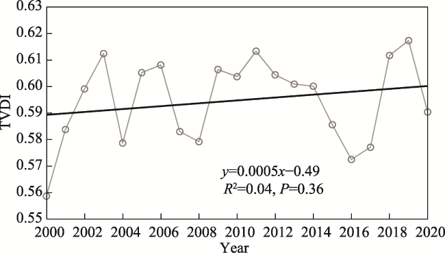
2014). While the TVDI did not change significantly from 2001 to 2020 in most areas of Sichuan Province, the changes were positively correlated with temperature, indicating that increasing temperature was the main reason for the increase in drought (Li et al., 2022). However, precipitation and temperature were found to have less impact on the variations of TVDI in Xinjiang, China (Huang et al., 2020a).
A hot-dry valley is formed by the combined effect of a complex geographic environment and the local microclimate. Hot-dry valleys are characterized by low vegetation cover, infertile soil, and severe water and soil losses. The lower reaches of the Jinsha River is one the main distribution areas of hot-dry valleys in China (Fan et al., 2020), where drought disasters are frequent and cause huge local socioeconomic losses (Lin et al., 2015; Fluixá-Sanmartín et al., 2018; Wang and Yu, 2021). Although the study area is in the humid climate zone, sustained droughts have happened frequently in the last decade, such as the summer of 2006, the autumn of 2009 to the spring of 2010, and the summer of 2011 (Lin et al., 2015). Previous studies have assessed the spatial and temporal distributions of drought in the region using point data from meteorological monitoring, but the high heterogeneity of the hot-dry valley makes it difficult to accurately monitor the spatiotemporal pattern of drought (Ju et al., 2021; Zhang et al., 2023). Therefore, this study aimed to: 1) Analyze the applicability of TVDI for drought monitoring in the cascade hydropower development zone of the Jinsha River; 2) Explore the spatial and temporal variation characteristics of drought in the study area; and 3) Use partial correlation analysis to explore the drivers of the interannual variation of drought. Our results can provide a reference for drought monitoring, drought prevention, and ecosystem protection in the study area.

2 Materials and methods

2.1 Overview of the study area

The study area is located from Panzhihua to Yibin, using the first ridge line around the Jinsha River as the boundary. It is an important clean energy corridor in China, with four large hydropower plants: Xiangjiaba, Xiluodu, Baihetan, and Wudongde (Fig. 1), whose combined annual power generation is equivalent to two Three Gorges power plants (Ju et al., 2021). The study area is located on the slope zone of the transition from the Qinghai-Tibet Plateau and the Yunnan- Guizhou Plateau to the Sichuan Basin, and it has a complex topography with plateaus, basins, canyons, hills, and valleys. The climate type belongs to the southern subtropical climate zone, with a mean annual air temperature of about 13 ℃ and annual precipitation of about 1000 mm, but with distinct dry and wet seasons and large interannual variations. The main soil type is red soil. Severe soil erosion and frequent drought disasters have been caused by a combination of geomorphological, climatic, and anthropogenic factors (Lin et al., 2015; Fluixá-Sanmartín et al., 2018; Shao et al., 2022). The main types of vegetation are forest and grass.
Fig. 1 Location, scope and relevant features of the study area

2.2 Data source and processing

MODIS land surface temperature (MOD11A2) and NDVI (MOD13A3) data from 2000 to 2020 were obtained from the official website of NASA https://ladsweb.modaps.eosdis.nasa.gov/search/ (accessed on Dec 2, 2021) and used to calculate the TVDI. Land surface temperature (LST) data from MOD11A2 were calculated from MODIS bands 31 and 32 using the split-window algorithm with a spatial resolution of 1 km and a temporal resolution of 8 days (Wan and Dozier 1996). NDVI data were derived from MOD13A3 with a spatial resolution of 1 km and a temporal resolution of 1 month. The LST and NDVI data were extracted from the original dataset, and data processing, such as image mosaicking, clipping, and projection conversion, was performed before generating the annual mean surface temperature and NDVI by the mean algorithm.
The air temperature at 2 m, precipitation, and soil moisture content at a depth of 0-7 cm were obtained from the ERA5-LAND monthly mean reanalysis dataset provided by the European Centre for Medium-Range Weather Forecasts (ECMWF), which is compiled through global high-resolution numerical integration of the ECMWF land surface model driven by downscaled meteorological forcing from the ERA5 climate reanalysis (Muñoz-Sabater et al. 2021). Although no data assimilation was performed, the observed data indirectly affected the simulation results. Compared to ERA5, ERA5-LAND has higher spatial resolution, with a horizontal resolution of up to 0.1° (9 km).

2.3 Research methodology

Drought events are influenced by many factors, such as precipitation, temperature, vegetation growth conditions, and soil properties, and there is a series of complex interactions among them (Huang et al., 2017a). According to the significant negative correlation between vegetation index and surface temperature, these two parameters were as used to construct the T-NDVI feature space, and the TVDI parameter was proposed to estimate drought conditions (Sandholt et al., 2002b). The TVDI values range from 0 to 1, with larger values indicating greater soil aridity and vice versa. The TVDI is calculated as follows:
$TVDI=\frac{T-{{T}_{\min }}}{{{T}_{\max }}-{{T}_{\min }}}$
$\begin{matrix} {{T}_{\max }}~=a~+b\times NDVI \\ \end{matrix}$
$\begin{matrix} {{T}_{\min }}~=c~+d\times NDVI \\ \end{matrix}$
where T is land surface temperature; Tmax and Tmin are the maximum and minimum land surface temperatures corresponding to a certain NDVI value, respectively; and a, b, c, and d are the coefficients of the linear fitting equation for the dry and wet edges, respectively.
The results of previous studies showed that when the vegetation cover is low, NDVI does not reflect the vegetation growth very well, so only the area with NDVI >0.2 was used to fit the TVDI wet and dry edge in this study (Wang et al., 2003; Cheng et al., 2022a; Cheng et al., 2022b). The annual mean surface temperature and NDVI data were imported into the TVDI extensions from the ENVI App Store, the NDVI minimum was set as 0.2, sample size was set as 1, and the output raster location was set. Clicking “OK” generated the output of the TVDI grid, and the wet and dry edge fitting data for a specific year.
According to the existing drought class classification (Cao et al., 2016; Cao et al., 2017; Guo et al., 2018) combined with the TVDI data in this study, the drought severity was classified into five classes: extremely wet (0≤TVDI<0.2), wet (0.2≤TVDI<0.4), normal (0.4≤TVDI<0.6), dry (0.6≤TVDI<0.8), and extremely dry (0.8≤TVDI≤1).

2.4 Analysis methods

The Theil-Sen median trend analysis and the Mann-Kendall nonparametric test were used to analyze the interannual trends of TVDI in the study area from 2000 to 2020 at the pixel level. The Theil-Sen slope is the median of the slopes calculated between observations at all pairwise time steps, and is insensitive to measurement error and outlier data (Liu et al., 2015). The Mann-Kendall trend test was used to evaluate the significance of the Theil-Sen slope estimate. The Mann-Kendall trend test does not require the sample to follow a specific distribution, and it is less affected by outliers, allows for missing values, and has the advantage of objectively characterizing the overall trend of a sample series, so it can effectively test the significance of the time series. The Theil-Sen slope can characterize the rate of interannual variation of TVDI; when the slope is greater than 0, it characterizes increasing drought, and when the slope is less than 0, it characterizes decreasing drought. The P-value of the Mann-Kendall trend test characterizes the significance of the annual trend of TVDI, and according to the P-value, we classified the annual trend of TVDI as either significant (P<0.05) or nonsignificant (P≥0.05).
The partial correlation coefficient is an index that measures the degree of linear correlation between two variables while controlling the effects of other variables. We used partial correlation analysis to explore the relative relationships between TVDI and climatic factors (temperature and precipitation), and the t-test to test the significance of the partial correlation coefficients, where P<0.05 indicates statistical significance. According to the significance of the partial correlations between the selected climatic factors and TVDI, the driving forces of drought were defined (Table 1). The regions where temperature and precipitation were both significantly correlated with TVDI (P<0.05) were defined as jointly driven by temperature and precipitation, the regions where temperature was significantly correlated with TVDI (P<0.05) but precipitation was not (P≥0.05) were defined as temperature driven, the regions where temperature was not significantly correlated with TVDI (P≥0.05) but precipitation was (P<0.05) were defined as precipitation driven, and the regions where neither temperature nor precipitation were not significantly correlated with TVDI (P≥0.05) were defined as not driven by temperature or precipitation (Table 1). We calculated the composition of the different driving forces under different interannual TVDI trends. R version 4.2.1 was used to run the code for spatiotemporal variation and driving forces analysis, and GeoScene was used to draw the relevant graphs.
Table 1 Classification of the type of driving forces of TVDI
Type of driving forces Basis of classification
Jointly driven by temperature and precipitation P1<0.05 and P2<0.05
Temperature driven P1<0.05 and P2≥0.05
Precipitation driven P1≥0.05 and P2<0.05
Not driven by temperature or precipitation P1≥0.05 and P2≥0.05

Note: P1 is significance of partial correlation coefficient between temperature and TVDI; P2 is significance of partial correlation coefficient between precipitation and TVDI.

3 Results

3.1 Applicability of TVDI for drought monitoring

The ERA5-LAND surface soil moisture content data were used to test the applicability of the TVDI for monitoring drought in the study area (Fig. 2). The TVDI has a strong negative linear correlation with surface soil moisture content (0-7 cm), decreasing by 0.0086 for every 1% increase in soil moisture content, indicating that the TVDI can be used for monitoring drought in the study area.
Fig. 2 Relationship between TVDI and soil moisture content from 0 to 7 cm

3.2 Spatial distribution characteristics of drought

The spatial distribution of the multi-year average TVDI from 2000 to 2020 is shown in Fig. 3a. The multi-year average value is 0.59, indicating that drought during the study period was at the normal level, but it was close to the dry level. The spatial heterogeneity of TVDI was very high; the coefficient of variation is 17.95%, the maximum value of the multi-year average TVDI is 0.88 and the minimum value is 0.10. The TVDI was generally higher in the valley areas at low elevations near the mainstream of the Jinsha River, while it was lower in the high-elevation and lake distribution areas. The multi-year averages TVDI in the study area indicated mainly dry and normal levels, with dry areas accounting for 48.5%, normal areas accounting for 45.0%, wet areas accounting for 4.6%, extremely dry areas accounting for 1.7%, and extremely wet areas accounting for 0.2%. The spatial distribution of the coefficient of variation shows that the interannual variation of TVDI was higher in areas with lower TVDI (Fig. 3b).
Fig. 3 Spatial distribution of multi-year average TVDI (a) and the coefficient of variation (b) from 2000 to 2020

3.3 Temporal variation characteristics of drought

The TVDI shows a fluctuating upward trend from 2000 to 2020 (Fig. 4), which indicates that the drought level in the study area became more severe, but this trend did not reach a level of significance (P > 0.05). The maximum value of TVDI was 0.62 in 2019, and the minimum value was 0.56 in 2000. During the 21 years from 2000 to 2020, the annual mean TVDI indicated a dry level in 11 years and a normal level in 10 years.
Fig. 4 Interannual variations of the TVDI value in study area
The slope of the interannual variation of TVDI from 2000 to 2020 ranged from −0.007 to 0.009, and has high spatial heterogeneity. The TVDI increased faster in the up stream of the study area, i.e., around Panzhihua City, while it mainly decreased in the downstream of the study area (Fig. 5). Overall, the area with decreasing TVDI accounted for 37% of the study area, and 4% of the study area showed significantly decreasing TVDI (P<0.05), indicating that 37% of the study area became wetter during the study period. The area with increasing TVDI accounted for 63% of the study area, and 21% of the study area showed significantly increasing TVDI (P<0.05), indicating that 63% of the study area became drier and 21% became significantly drier.
Fig. 5 Spatial distribution of interannual trends of the TVDI
The drought levels also underwent obvious changes, and a drought class conversion matrix was created based on the drought levels in 2000 and 2020 (Table 2). The data in the table show that the rate of drought level change was 19.5% and the area that became dry (17.9%) was greater than the area that became wet (1.6%). The largest transformation was from normal to dry, accounting for 14.5% of the study area, followed by the transformation from wet to normal (1.8%) and then dry to extremely dry (1.4%).
Table 2 Changes in the areas of different drought levels from 2000 to 2020 (%)
Drought type 2020
Extremely wet Wet Normal Dry Extremely dry
2000 Extremely wet 0.22 0.12 0 0 0
Wet 0.08 5.06 1.84 0 0
Normal 0 0.39 41.11 14.51 0
Dry 0 0 1.14 33.56 1.40
Extremely dry 0 0 0 0.03 0.55
At the same time, the trends of annual changes in TVDI under different drought levels show obvious differences (Fig. 6). Except for the areas at a normal level, the other areas had a higher percentage of increasing than decreasing TVDI, indicating that these areas became dry during the study period. Increasing drought was the most obvious in areas at an extremely dry level, with increasing TVDI in 99% of the areas and significantly increasing TVDI in 69% of the areas (P<0.05). The areas at a normal level had a higher decreasing trend (58%) than increasing trend (42%), indicating that these areas mainly became wetter during the study period.
Fig. 6 Trends in the percentage of change of TVDI under different drought levels from 2000 to 2020

3.4 Relationship between drought variation and climatic factors

During the study period, the mean annual air temperature in the study area ranged from 12.81 ℃ (in 2000) to 14.71 ℃ (in 2019), with a multi-year mean of 13.73 ℃. The mean annual temperature from 2000 to 2020 showed a significantly increasing trend (P<0.01), and the rate of increase was 0.4 ℃ per decade. The mean annual precipitation in the study area ranged from 1186 mm (in 2011) to 1723 mm (in 2008), with a multi-year mean of 1508 mm and a nonsignificantly decreasing trend (P=0.21), and the rate of decrease was 61 mm per decade.
The temporal variation of TVDI in the study area was significantly correlated with climatic factors (Fig. 7). Air temperature was significantly positively correlated with TVDI (P<0.01), and precipitation was significantly negatively correlated with TVDI (P<0.01). Partial correlation analysis showed that the partial correlation coefficient between air temperature and TVDI was −0.73 (P<0.01), and the coefficient between precipitation and TVDI was −0.46 (P = 0.04), indicating that the increasing air temperature and decreasing precipitation were the main reasons for the increases in TVDI and drought in the study area during the study period.
Fig. 7 Relationships between TVDI and (a) temperature and (b) precipitation in the study area from 2000 to 2020
The partial correlation coefficients between TVDI and mean annual average air temperature ranged from −0.63 to 0.93 (Fig. 8a), and were highly spatially heterogeneous. The area where TVDI was negatively correlated with mean annual air temperature accounted for 14% of the study area, mainly located downstream around the Xiangjiaba and Xiluodu hydropower plants, and this area does not belong to the hot-dry valley. The partial correlation coefficient between TVDI and mean annual air temperature had a significantly negative correlation (P<0.05) for 0.36% of the study area. The positive correlation between TVDI and mean annual air temperature accounted for 86% of the study area, and this positive correlation was stronger in the hot-dry valley portion located upstream. The t-test of the partial correlation coefficient showed a significantly positive correlation (P<0.05) for 43% of the study area.
Fig. 8 Spatial distributions of the partial correlation coefficients between TVDI and (a) temperature and (b) precipitation

Note: Gray masking indicates that the correlation coefficient reached a significant level (P < 0.05).

The partial correlation coefficients between TVDI and annual average precipitation ranged from −0.89 to 0.42 (Fig. 8b). The negative partial correlation coefficients accounted for 98% of the study area, and for 34% of the study area, they passed the significance test at P<0.05.
The composition of driving forces in the study area includes four categories. The areas not driven by temperature or precipitation account for 36%, those driven by temperature account for 30%, those driven by precipitation account for 21%, and those jointly driven by temperature and precipitation account for 13%. The driving forces were clearly different for areas with different levels of interannual variation of TVDI (Fig. 9). In 73% of the areas with significantly decreasing TVDI, the TVDI variation was not driven by temperature or precipitation, while in 24% of the areas it was driven by precipitation, and air temperature had little effect on the TVDI variation in areas with significantly decreasing TVDI. In 55% of the regions with nonsignificantly decreasing interannual TVDI variability, the TVDI variation was not driven by temperature or precipitation, while in 32% it was driven by precipitation, and in 9% it was driven by temperature. In 35% of the regions with nonsignificantly increasing interannual TVDI variation, the TVDI variation was driven by temperature, while in 27% it was not driven by temperature or precipitation, in 20% it was jointly driven by temperature and precipitation, and in 18% it was driven by precipitation. In 60% of the regions with significantly increasing interannual TVDI variability, the TVDI variation was driven by temperature, while in 17% it was not driven by temperature or precipitation, in 16% it was jointly driven by temperature and precipitation, and in 7% it was driven by precipitation.
Fig. 9 Percentages of driving forces in areas with the different trends of TVDI changes

4 Discussion

4.1 TVDI is applicable for drought monitoring in the study area

There are various methods for monitoring drought using remote sensing data, each of which have their own advantages and applicability, and the most appropriate methods should be chosen for different areas. The general feasibility of using TVDI for drought monitoring has been well demonstrated by previous research results (Liu et al., 2016; Huang et al., 2020a; Nugraha et al., 2023). Studies in the Mongolian Plateau found that TVDI was strongly correlated with soil moisture content at 0-10 cm, suggesting that it is suitable for monitoring drought conditions in the region (Cao et al., 2016; Cao et al., 2017). The soil moisture content at 0-15 cm showed a strong negative correlation (R2 = 0.85) with MODIS-based TVDI in Razavi Khorasan province of Iran (Zormand et al., 2017). Similarly, the TVDI in northwestern Bangladesh calculated from Landsat remote sensing imagery had a significant linear correlation (R2 = 0.83) with soil moisture content (Sharma et al., 2022). In addition, the TVDI in Yunnan, where the study area of this study is mainly located, was significantly correlated with topsoil moisture content in the 10 cm and 20 cm layers (Yang et al., 2017), and the range of drought occurrence based on TVDI was consistent with the actual scope of the droughts that occurred according to yearbook data (Long et al., 2012), indicating the feasibility of using TVDI to monitor drought in Yunnan. In this study, we found a significantly negative linear relationship between TVDI and soil moisture content (Fig. 2), indicating the applicability of TVDI for monitoring drought in the study area.

4.2 Similar distributions of TVDI and the hot-dry valley

The multi-year average TVDI for the study area was 0.59, indicating relatively severe drought. The average TVDI in 2019 reached 0.62, the highest value in recent years, which is consistent with the occurrence of a severe drought event in Yunnan in that year. The overall drought in the study area during the study period was between normal and drought levels, indicating that the study area was highly vulnerable to drought. The hot-dry valley is mainly distributed in the upstream of the study area from Panzhihua to Chuxiong; and we found that the TVDI was quite high in these valley areas, indicating that the distribution of drought areas was consistent with the actual situation of drought distribution (Fan et al., 2020).

4.3 Aggravation of drought conditions from 2000 to 2020

The average TVDI in the study area showed a fluctuating increasing trend (Fig. 4), the percentage of the area with an increasing TVDI was higher than that with decreasing TVDI (Fig. 5), and the percentage of the area with increasing drought (17.9%) was higher than that with decreasing drought (1.6%) from 2000 to 2020 (Table 2). These results indicate an aggravation of drought conditions in the study area. Previous studies also found that the area and frequency of drought have increased in the upper Yangtze River region (Lin et al., 2015; Yuan et al., 2017; Ju et al., 2021; Zhang et al., 2023). For example, a study in the Central Yunnan Plateau found that the TVDI and the dry and extremely dry areas increased significantly from 2001 to 2020 (Qu et al., 2022). The hot-dry valley ecosystem is characterized by a low vegetation cover and severe water and soil losses, which makes it sensitive to drought. The aggravation of drought may reduce the vegetation cover, ecosystem productivity, and ecosystem stability. “Dry gets drier, wet gets wetter” is a standard catchphrase that has been frequently used in previous studies to characterize the effect of climate change (Greve et al., 2014; Donat et al., 2016). According to our results, we found that the percentage of areas with increasing TVDI was much higher than the percentage with decreasing TVDI under dry and extremely dry conditions, indicating that dry became drier. However, we also found that the percentage of areas with increasing TVDI was higher than the percentage with decreasing TVDI under wet and extremely wet conditions, indicating that wet also became drier in the study area during the study period.

4.4 Driving forces of drought

Temperature and precipitation are the main factors affecting drought. A significant increase in temperature in the study area under global change conditions could intensify water transpiration loss, while a reduction in precipitation could directly reduce water availability, and the combination of these two factors will lead to increasing drought conditions (Seneviratne et al., 2010). The analysis of driving forces showed that temperature was the main cause of the increasing TVDI in areas with worsening drought (i.e., with significantly and nonsignificantly increasing TVDI). Especially in areas with significantly increasing TVDI, the variation of TVDI was related to temperature in 76% of the region; while an increase in temperature will lead to an increase in transpiration and a decrease in soil moisture content, resulting in increasing drought in the study area (Yuan et al., 2017; Yan et al., 2019b; Zhang et al., 2023). Therefore, the increase in temperature was the main major reason for the aggravation of drought in the study area. Previous studies also found that an increase in temperature was the main reason for the increasing aggravation of drought in the study area (Liang et al., 2014; Li et al., 2022). The slightly reduced precipitation could directly aggravate the water shortage, leading to increasing TVDI and further aggravating the drought situation.

4.5 Uncertainty analysis

There are some uncertainties in this study. Firstly, this study only explored the interannual variation of drought conditions, so the spatiotemporal variation characteristics of drought in different seasons and months are still unclear. Seasonal and monthly variations of drought will also have a strong effect on ecosystem health. Secondly, although our results indicate that the TVDI is suitable for monitoring the drought conditions of the entire study area, it is still unclear whether TVDI would be suitable for monitoring drought in specific locations. Furthermore, this article only analyzes the effects of temperature and precipitation on the interannual variation of drought, while the effects of human activities on variations in drought also need to be clarified.

5 Conclusions

This study found that the TVDI can accurately reflect the drought situation in the lower reaches of the Jinsha River. The multi-year average TVDI was 0.59, and the overall drought level was between normal and dry from 2000 to 2020. The dry level accounted for 48.5% of the study area, and was mainly located in the hot-dry valley distributed upstream. The normal level accounted for 45.0% of the study area, and was mainly located in the downstream area. From 2000 to 2020, the drought level showed an increasing trend, and the areas with increasing drought accounted for 63% of the study area, including 21% with significantly increasing drought. The percentage of area with increasing drought in 2020 compared to 2000 (17.9%) was higher than that with decreasing drought (1.6%), and both dry and wet areas in the study area became drier. TVDI was positively correlated with air temperature in 86% of the area and significantly positively correlated with air temperature in 43% of the area, while precipitation was negatively correlated with TVDI in 98% of the area and significantly negatively correlated in 34% of the area. In 76% of areas with significantly increasing drought, the increase in drought was significantly correlated with temperature. Increasing temperature is an important cause of increasing drought, followed by decreasing precipitation. Effective measures must be taken immediately to mitigate the adverse effects of climate change on the drought situation in the lower reaches of the Jinsha River.
[1]
Alley W M. 1984. The palmer drought severity index—Limitations and assumptions. Journal of Climate and Applied Meteorology, 23(7): 1100-1109.

DOI

[2]
Amani M, Salehi B, Mahdavi S, et al. 2017. Temperature-Vegetation-soil Moisture Dryness Index (TVMDI). Remote Sensing of Environment, 197: 1-14.

DOI

[3]
Anderson M C, Norman J M, Mecikalski J R, et al. 2007. A climatological study of evapotranspiration and moisture stress across the continental United States based on thermal remote sensing: 1. Model formulation. Journal of Geophysical Research—Atmospheres, 112(D10117). DOI: 10.1029/2006JD007506.

[4]
Cao X, Feng Y, Shi Z. 2020. Spatio-temporal variations in drought with remote sensing from the Mongolian Plateau during 1982-2018. Chinese Geographical Science, 30(6): 1081-1094.

DOI

[5]
Cao X, Feng Y, Wang J. 2016. An improvement of the Ts-NDVI space drought monitoring method and its applications in the Mongolian Plateau with MODIS, 2000-2012. Arabian Journal of Geosciences, 9(6): 433. DOI: 10.1007/s12517-016-2451-5.

[6]
Cao X, Feng Y, Wang J. 2017. Remote sensing monitoring the spatio-temporal changes of aridification in the Mongolian Plateau based on the general Ts-NDVI space, 1981-2012. Journal of Earth System Science, 126(4): 58. DOI: 10.1007/s12040-017-0835-x.

[7]
Chang S, Wu B F, Yan N N, et al. 2017. Suitability assessment of satellite-derived drought indices for Mongolian grassland. Remote Sensing, 9(7): 650. DOI: 10.3390/rs9070650.

[8]
Cheng M, Cao G, Zhao M, et al. 2022a. Temporal and spatial variation characteristics and influencial factors of soil moisture in the Xiangride-Qaidam River Basin. Arid Zone Research, 39(2): 615-624.

[9]
Cheng X, Zhou Z, Li W, et al. 2022b. Monitoring drought situation and analyzing influencing factors in Central Asia using MODIS data. Transactions of the Chinese Society of Agricultural Engineering, 38(10): 128-137.

[10]
Chou C, Chiang J C H, Lan C-W, et al. 2013. Increase in the range between wet and dry season precipitation. Nature Geoscience, 6(4): 263-267.

DOI

[11]
Dai L, Zhao Y, Yin C, et al. 2023. Spatial and temporal dynamics of drought and waterlogging in Karst mountains in southwest China. Sustainability, 15(6): 5545. DOI: 10.3390/su15065545.

[12]
Donat M G, Lowry A L, Alexander L V, et al. 2016. More extreme precipitation in the world’s dry and wet regions. Nature Climate Change, 6(5): 508-513.

DOI

[13]
Du L T, Song N P, Liu K, et al. 2017. Comparison of two simulation methods of the Temperature Vegetation Dryness Index (TVDI) for drought monitoring in semi-arid regions of China. Remote Sensing, 9(2): 177. DOI: 10.3390/rs9020177.

[14]
Fan J, Yang C, Bao W, et al. 2020. Distribution scope and district statistical analysis of dry valleys in southwest China. Mountain Research, 38(2): 303-313. (in Chinese)

[15]
Fluixá-Sanmartín J, Pan D, Fischer L, et al. 2018. Searching for the optimal drought index and timescale combination to detect drought: A case study from the lower Jinsha River Basin, China. Hydrology and Earth System Sciences, 22(1): 889-910.

DOI

[16]
Greve P, Orlowsky B, Mueller B, et al. 2014. Global assessment of trends in wetting and drying over land. Nature Geoscience, 7(10): 716-721.

DOI

[17]
Gu Y X, Brown J F, Verdin J P, et al. 2007. A five-year analysis of MODIS NDVI and NDWI for grassland drought assessment over the central Great Plains of the United States. Geophysical Research Letters, 34(6): L06407. DOI: 10.1029/2006gl029127.

[18]
Guo R, Guo Q, Feng Y, et al. 2018. Analysis of the factors affecting the spatiotemporal soil moisture distribution based on the temperature-vegetation drought index. Journal of Irrigation and Drainage, 37(4): 52-58. (in Chinese)

[19]
Han L, Zhang Q, Yao Y, et al. 2014. Characteristics and origins of drought disasters in Southwest China in nearly 60 years. Acta Geographica Sinica, 69(5): 632-639. (in Chinese)

DOI

[20]
Huang J, Li Y, Fu C, et al. 2017a. Dryland climate change: Recent progress and challenges. Reviews of Geophysics, 55(3): 719-778.

DOI

[21]
Huang J, Zhang Y, Wang M, et al. 2020a. Spatial and temporal distribution characteristics of drought and its relationship with meteorological factors in Xinjiang in last 17 years. Acta Ecologica Sinica, 40(3): 1077-1088. (in Chinese)

[22]
Huang J P, Yu H P, Dai A G, et al. 2017b. Drylands face potential threat under 2 ℃ global warming target. Nature Climate Change, 7(6): 417-422.

DOI

[23]
Huang J P, Yu H P, Guan X D, et al. 2016. Accelerated dryland expansion under climate change. Nature Climate Change, 6(2): 166-171.

DOI

[24]
Huang J X, Zhuo W, Li Y, et al. 2020b. Comparison of three remotely sensed drought indices for assessing the impact of drought on winter wheat yield. International Journal of Digital Earth, 13(4): 504-526.

DOI

[25]
Ju X, Wang Y, Wang D, et al. 2021. A time-varying drought identification and frequency analyzation method: A case study of Jinsha River Basin. Journal of Hydrology, 603: 126864. DOI: 10.1016/j.jhydrol.2021.126864.

[26]
Kogan F N. 1995. Application of vegetation index and brightness temperature for drought detection. Advances in Space Research, 15(11): 91-100.

[27]
Lawal S, Hewitson B, Egbebiyi T S, et al. 2021. On the suitability of using vegetation indices to monitor the response of Africa’s terrestrial ecoregions to drought. Science of the Total Environment, 792: 148282. DOI: 10.1016/j.scitotenv.2021.148282.

[28]
Li C, Benjamin A, Wu J, et al. 2022. Spatial and temporal variations of drought in Sichuan Province from 2001 to 2020 based on modified Temperature Vegetation Dryness Index (TVDI). Ecological Indicators, 139: 108883. DOI: 10.1016/j.ecolind.2022.109106.

[29]
Li C, Fu B, Wang S, et al. 2021. Drivers and impacts of changes in China’s drylands. Nature Reviews Earth & Environment, 2(12): 858-873.

[30]
Liang L, Zhao S H, Qin Z H, et al. 2014. Drought change trend using MODIS TVDI and its relationship with climate factors in China from 2001 to 2010. Journal of Integrative Agriculture, 13(7): 1501-1508.

DOI

[31]
Lin W, Wen C, Wen Z, et al. 2015. Drought in southwest China: A review. Atmospheric and Oceanic Science Letters, 8(6): 339-344.

[32]
Liu C, Allan R P. 2013. Observed and simulated precipitation responses in wet and dry regions 1850-2100. Environmental Research Letters, 8(3): 034002. DOI: 10.1088/1748-9326/8/3/034002.

[33]
Liu H, Zhang A, Jiang T, et al. 2016. The spatiotemporal variation of drought in the Beijing-Tianjin-Hebei Metropolitan Region (BTHMR) based on the modified TVDI. Sustainability, 8(12): 1327. DOI: 10.339 0/su8121327.

[34]
Liu Y, Wang Y, Peng J, et al. 2015. Correlations between urbanization and vegetation degradation across the world’s metropolises using DMSP/OLS nighttime light data. Remote Sensing, 7(2): 2067-2088.

DOI

[35]
Long X, Wang L, Yang R, et al. 2012. Remote sensing monitoring of drought based on Temperature Vegetation Dryness Index in Yunnan Province. China Rural Water and Hydropower, (11): 136-139. (in Chinese)

[36]
Lopez-Moreno J I, Vicente-Serrano S M, Zabalza J, et al. 2013. Hydrological response to climate variability at different time scales: A study in the Ebro Basin. Journal of Hydrology, 477: 175-188.

DOI

[37]
Mckee T B, Doesken N J, Kleist J. 1993. The relationship of drought frequency and duration to time scales. In:Proceedings of the Eighth Conference on Applied Climatology, January 17-22, 1993. Anaheim, CA, American Meteorological Society: 179-184.

[38]
Mcvicar T R, Jupp D L B. 1998. The current and potential operational uses of remote sensing to aid decisions on drought exceptional circumstances in Australia: A review. Agricultural Systems, 57(3): 399-468.

DOI

[39]
Muñoz-Sabater J, Dutra E, Agustí-Panareda A, et al. 2021. ERA5-Land: A state-of-the-art global reanalysis dataset for land applications. Earth System Science Data, 13(9): 4349-4383.

DOI

[40]
Nugraha A S A, Kamal M, Murti S H, et al. 2023. Development of the triangle method for drought studies based on remote sensing images: A review. Remote Sensing Applications: Society and Environment, 29: 100920. DOI: 10.1016/j.rsase.2023.100920.

[41]
Piao S, Ciais P, Huang Y, et al. 2010. The impacts of climate change on water resources and agriculture in China. Nature, 467(7311): 43-51.

DOI

[42]
Pörtner H-O, Roberts D C, Adams H, et al. 2022. Climate change 2022: Impacts, adaptation and vulnerability. Geneva, Switzerland: IPCC.

[43]
Qu X, He Y, Yan W, et al. 2022. Spatial-temporal variation of agricultural drought on Central Yunnan Plateau based on MODIS data. Journal of Yunnan University (Natural Science), 44(4): 744-753.

[44]
Rahimzadeh-Bajgiran P, Omasa K, Shimizu Y. 2012. Comparative evaluation of the Vegetation Dryness Index (VDI), the Temperature Vegetation Dryness Index (TVDI) and the improved TVDI (iTVDI) for water stress detection in semi-arid regions of Iran. Isprs Journal of Photogrammetry and Remote Sensing, 68: 1-12.

DOI

[45]
Rhee J, Im J, Carbone G J. 2010. Monitoring agricultural drought for arid and humid regions using multi-sensor remote sensing data. Remote Sensing of Environment, 114(12): 2875-2887.

DOI

[46]
Sandholt I, Rasmussen K, Andersen J. 2002a. A simple interpretation of the surface temperature/vegetation index space for assessment of surface moisture status. Remote Sensing of Environment, 79(2-3): 213-224.

DOI

[47]
Sandholt I, Rasmussen K, Andersen J. 2002b. A simple interpretation of the surface temperature/vegetation index space for assessment of surface moisture status. Remote Sensing of Environment, 79(2): 213-224.

DOI

[48]
Seneviratne S I, Corti T, Davin E L, et al. 2010. Investigating soil moisture-climate interactions in a changing climate: A review. Earth-Science Reviews, 99(3-4): 125-161.

DOI

[49]
Shao H, Zhang Y, Yu Z, et al. 2022. The resilience of vegetation to the 2009/2010 extreme drought in southwest China. Forests, 13(6): 851. DOI: 10.3390/f13060851.

[50]
Sharma A P M, Jhajharia D, Gupta S, et al. 2022. Multiple indices based agricultural drought assessment in Tripura, northeast India. Arabian Journal of Geosciences, 15(7): 636. DOI: 10.1007/s12517-022-09855-0.

[51]
Stisen S, Sandholt I, Norgaard A, et al. 2008. Combining the triangle method with thermal inertia to estimate regional evapotranspiration— Applied to MSG-SEVIRI data in the Senegal River Basin. Remote Sensing of Environment, 112(3): 1242-1255.

DOI

[52]
Tao L L, Ryu D, Western A, et al. 2021. A new drought index for soil moisture monitoring based on MPDI-NDVI trapezoid space using MODIS data. Remote Sensing, 13(1): 122. DOI: 10.3390/rs13010122.

[53]
Wan Z, Dozier J. 1996. A generalized split-window algorithm for retrieving land-surface temperature from space. IEEE Transactions on Geoscience and Remote Sensing, 34(4): 892-905.

DOI

[54]
Wang J, Yu Y. 2021. Comprehensive drought monitoring in Yunnan Province, China using multisource remote sensing data. Journal of Mountain Science, 18(6): 1537-1549.

DOI

[55]
Wang Z, Liu C, Alfredo H. 2003. From AVHRR-NDVI to MODIS-EVI: Advances in vegetation index research. Acta Ecologica Sinica, 23(5): 979-987. (in Chinese)

[56]
Yan H B, Zhou G, Yang F F, et al. 2019a. DEM correction to the TVDI method on drought monitoring in karst areas. International Journal of Remote Sensing, 40(5-6): 2166-2189.

DOI

[57]
Yan J, Zhang G, Deng X, et al. 2019b. Does climate change or human activity lead to the degradation in the grassland ecosystem in a mountain-basin system in an arid region of China? Sustainability, 11(9): 2618. DOI: 10.3390/su11092618.

[58]
Yang R W, Wang H, Hu J M, et al. 2017. An improved Temperature Vegetation Dryness Index (iTVDI) and its applicability to drought monitoring. Journal of Mountain Science, 14(11): 2284-2294.

DOI

[59]
Yuan Z, Xu J, Chen J, et al. 2017. Drought assessment and projection under climate change: A case study in the middle and lower Jinsha River Basin. Advances in Meteorology, 2017: 5757238. DOI: 10.1155/2017/5757238.

[60]
Zambrano F, Lillo-Saavedra M, Verbist K, et al. 2016. Sixteen years of agricultural drought assessment of the BioBio Region in Chile using a 250 m resolution Vegetation Condition Index (VCI). Remote Sensing, 8(6): 530. DOI: 10.3390/rs8060530.

[61]
Zhang L F, Jiao W Z, Zhang H M, et al. 2017. Studying drought phenomena in the Continental United States in 2011 and 2012 using various drought indices. Remote Sensing of Environment, 190: 96-106.

DOI

[62]
Zhang M, Huang X, Ren W. 2023. Spatial-temporal characteristics of meteorological drought in Jinsha River based on SPEI index. China Rural Water and Hydropower, (1): 95-101. (in Chinese)

DOI

[63]
Zhou J, Tang H, Qiu Y, et al. 2023. Spatio-temporal changes and influencing factors of meteorological dry-wet in Northern China during 1960-2019. Sustainability, 15(2): 1499. DOI: 10.3390/su15021499.

[64]
Zormand S, Jafari R, Koupaei S S. 2017. Assessment of PDI, MPDI and TVDI drought indices derived from MODIS Aqua/Terra Level 1B data in natural lands. Natural Hazards, 86(2): 757-777.

DOI

Outlines

/