Ecosystem and Ecological Security

A Resilience Enhancement Approach to the Sponge City based on Ecosystem-based Disaster Risk Reduction—Taking the Urban Design of Jiangchuanlu Street in Shanghai, China as an Example

  • DAI Daixin , 1, 2, * ,
  • BO Mingyang 1, 2
Expand
  • 1. College of Architecture and Urban Planning, Tongji University, Shanghai 200092, China
  • 2. State Key Laboratory of Civil Engineering Disaster Prevention, Tongji University, Shanghai 200092, China
* DAI Daixin, E-mail:

Received date: 2022-06-30

  Accepted date: 2023-02-20

  Online published: 2023-10-23

Supported by

Research on Coupled Risk Assessment and Ecosystem-based Disaster Risk Reduction of Urban Natural Disasters(22-3-YB-13)

Abstract

Against the backdrop of global climate change, the threat of extreme rainfall and flooding hazards to urban safety is becoming increasingly serious, and there is an urgent need to improve the resilience of cities through the construction of sponge cities. However, improving the sponge city’s capacity for resisting the risk of urban flooding is challenging. The relevant concept of ecosystem-based disaster risk reduction (Eco-DRR) is currently one of the main international theories of urban resilience, and it has important value for enhancing urban stormwater resilience. An approach for improving the stormwater resilience of sponge cities is presented in this paper, using the urban design of Jiangchuanlu Street in Shanghai as an example and the stormwater model to simulate flood disasters on Jiangchuanlu Street. In addition to the simulation results, the population and property conditions of the site were combined in order to conduct a comprehensive risk assessment through the risk matrix. Then, the Eco-DRR measures were implemented to enhance the urban stormwater resilience of Jiangchuanlu Street based on the assessment results. Finally, the ecological infrastructure of the study area was constructed, and the safety and health units were created on the basis of the ecological substrate to prevent and respond to public health emergencies. The results show that the stormwater resilience enhancement approach based on Eco-DRR can effectively alleviate the flood risk of Jiangchuanlu Street. At the same time, the safety and health units created through the ecological infrastructure can also help to prevent and respond to public health emergencies. The results of this study provide a resilience enhancement approach for sponge cities based on Eco-DRR, as well as a theoretical reference for the planning and construction of safe and resilient cities.

Cite this article

DAI Daixin , BO Mingyang . A Resilience Enhancement Approach to the Sponge City based on Ecosystem-based Disaster Risk Reduction—Taking the Urban Design of Jiangchuanlu Street in Shanghai, China as an Example[J]. Journal of Resources and Ecology, 2023 , 14(6) : 1113 -1126 . DOI: 10.5814/j.issn.1674-764x.2023.06.001

1 Introduction

In the context of the current global climate change, the frequency of extreme natural disaster events is growing, and so our cities will face more severe impacts from heavy rainfall and flooding in the future (Pan et al., 2021). Flooding is the most frequently occurring natural hazard globally, causing widespread life and property losses every year (Zhi et al., 2020). China has the climatic characteristics of rain and flooding in the same period, which causes more severe flood disasters and serious disaster losses, such as the serious flood disasters which followed exceptionally heavy rains in Henan Province, Hubei Province, Shanxi Province, and other places in China. At the same time, with the advancement of urbanization in China, cities are gathering more and more people and wealth while facing these risks of extreme conditions. In the face of increasingly severe and frequent rainfall disasters, there is an urgent need to prevent and reduce the negative impacts of flooding disasters by improving urban stormwater resilience. As a result, China has proposed improvements in urban stormwater resilience by promoting a sponge city construction system (Li et al., 2022). Sponge cities, like all planning and design issues, are characterized by wicked problems (Hartmann, 2012). For this reason, many problems arise in the construction of sponge cities, especially when faced with flooding disasters. At present, the most difficult issues in sponge city construction are related to their effectiveness and the inadequate use of risk assessment and digital technology tools.
Firstly, the current sponge city construction approach in China is not effective in resisting the risk of urban flooding. The concept of “sponge cities” was initially introduced from abroad, and almost all of the measures and standards are based on foreign design schemes and technical standards, which are not necessarily applicable to the climate characteristics of China, resulting in sponge city construction that can easily be undermined by heavy rainfall (Pan et al., 2021). For this reason, sponge cities in China should not only focus on absorbing rainwater but also pay attention to the problem of runoff control after saturation (Zhang, 2021). In extreme weather conditions, the rainwater resistance strategies are no longer effective, but the disaster prevention and mitigation strategies need to be ready when urban flooding occurs, which can help safeguard people’s lives and property (She et al., 2021).
Secondly, insufficient attention has been paid to disaster risk assessment and digital technology tools. Rainfall is likely to increase year by year with the persistence of climate change, thus our cities will be facing more severe impacts of heavy rainfall and flooding in the future. As a result, there is an urgent need for risk assessments in sponge cities to cope with the impending flooding hazards. This requires conducting stormwater risk assessments which consider the preconditions and influencing factors for rainfall flooding, such as assessing the drainage capacity of the immediate rainfall management system using numerical simulations (Li et al., 2021a). Such assessments can help in accurately identifying the risk areas that need to be prioritized for prevention and control, and in delineating stormwater risk areas under different intensities, which is beneficial for facilitating the development of systematic prevention, solution, and improvement measures.
After years of sponge city construction policies, the public has accepted ecological infrastructure as the main future trend for drainage systems and water restoration (Yuan et al., 2017; Yu and Gong, 2021). As a result, the further enhancement of stormwater resilience requires sponge city construction to give full play to the ecological infrastructure. At the large spatial scale, emphasis is placed on the harmonious coexistence of natural and urban spaces, and the full use of the blue-green-grey infrastructure system to form a substrate for rainwater control; while at the microscopic facility scale, the use of ecological infrastructure is strengthened to compensate for the lack of flexibility and resilience of the large urban grey facilities (Li et al., 2022). Therefore, ecological infrastructure not only facilitates the construction of a stormwater resilient city but also performs a more integrated urban ecological function.
The development and evolution of the concept of resilience have successively gone through “engineering resilience-ecological resilience - evolutionary resilience”, with extending extensions, enriching connotations, and increasing attention (Zhai, 2018). Its core concept is an emphasis on the system’s ability to resist, absorb, adapt and recover from disturbances, shocks, or uncertainties without changing its basic situation. At the beginning of this century, resilience theory was widely applied to urban systems and gradually extended to the urban planning fields, while the construction of sponge cities with features of “natural storage, natural infiltration, and natural purification”, as well as the promotion of ecological infrastructure integration, are important initiatives for enhancing urban stormwater resilience (Li et al., 2022). Furthermore, the construction of resilient cities is moving towards the construction of safe and resilient cities in order to face the growing uncertainties and unknown risks. “The safety and health units” are the smallest component of a safe and resilient city that can respond independently to disasters or accidents. They are a combination of “habitat space” and “health facility units” with geographical boundaries, and can quickly adapt to and resolve epidemics and the disasters they bring through a sound overall layout and continuous functional operation (Qian et al., 2020). In addition, these units can be created based on ecological infrastructure to prevent and respond to major public health emergencies, such as the “Covid-19” pneumonia epidemic, while constructing ecological infrastructure to solve the problem of rainfall and flooding (Chen and Cha, 2021). Thus, ecological infrastructure construction can not only promote urban stormwater resilience but also help to build the safety and health units for resolving epidemics.
Eco-DRR is one of the main current international theories of resilient disaster prevention and mitigation, and it is based on the combination of nature-based solutions and DRR theory, which is defined (Sudmeier-rieux and Estrella, 2013) as “disaster risk reduction through sustainable management, conservation, and restoration of ecosystems to achieve sustainable and resilient development”. The Eco-DRR implementation process focuses on the risk assessment of natural disasters and the application of natural-based solutions (Doswald and Estrella, 2015). As a result, Eco-DRR has important reference values for constructing a sponge city ecological infrastructure system to reduce the risk of flood disasters and enhance urban stormwater resilience. However, Tong and Bao (2022) recently reviewed 22 international cities’ climate adaptation planning documents related to current urban-level climate adaptation planning, and found that policy measures and traditional engineering measures remain the main climate response methods, and the application of the ecosystem-based solutions is still insufficient. In addition, there has been research on enhancing the resilience of sponge cities by optimizing the green infrastructure pattern (Zhu and Weng, 2021; Hua et al., 2022), and ecological restoration measures have also been implemented to protect the Yellow River floodplains from flood disasters (Yu and Gong, 2021). These methods and strategies coincide with the Eco-DRR theory but do not directly refer to it, and they ignore risk assessment which is the important step of the Eco-DRR implementation process, so there is a disconnect between current theory and practical applications. As a result, it is necessary to apply Eco-DRR theory to the practice of sponge city construction, which will help to greatly improve urban stormwater resilience.
In summary, constructing a sponge city ecological infrastructure system based on Eco-DRR can not only improve urban stormwater disaster response capacity and stormwater resilience, but it can also promote the overall quality of the community’s healthy environment for preventing and responding to public health emergencies. This approach can provide a new perspective for the research of sponge city construction, and also theoretical references for the planning and construction of resilient cities.

2 Materials and methods

2.1 Theoretical framework

This study proposes a framework of sponge city resilience enhancement (Fig. 1), and this framework follows an approach of three measures. First, stormwater risks are accurately identified through stormwater model analysis. Second, a comprehensive risk assessment is conducted considering the vulnerability of disaster-bearing bodies. Third, the ecological infrastructure for sponge cities is constructed based on Eco-DRR depending on the risk assessment. In addition, safety and health units are delineated based on the ecological substrate.
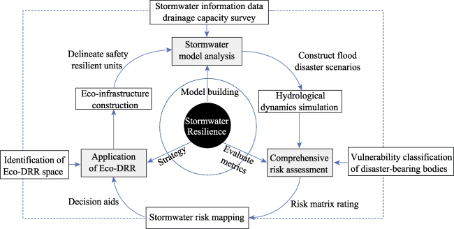
Fig. 1 The framework of sponge city resilience enhancement

2.1.1 Stormwater model analysis

Stormwater management should include comprehensively and systematically sorting out the preconditions and influencing factors of stormwater generation, and the risk assessment should be carried out scientifically, however, the risk assessment of stormwater in China is still generally in its initial stage (Li et al., 2022). To improve the accurate quantification of stormwater risk, digital simulation techniques are widely used in assessing the risk of stormwater. Urban stormwater models based on LISFLOOD-FP (a 2D hydrodynamic model) and SWMM (a 1D model for a drainage system) have already been applied in stormwater simulation and risk assessment work. This model can simulate rainfall in different recurrence periods and derive the inundation range and water depth caused by urban flooding, which is of great importance for urban stormwater risk assessment and risk reduction. However, the application of this model only considers the risk of urban waterlogging due to heavy rainfall in the current situation (Zeng et al., 2017; Zhou et al., 2020; Li et al., 2021b; Xu, 2021), but it neglects the threat of river flooding caused by storm surges at the same time. In the context of climate change and urban expansion, heavy rainfall events and sea-level rise are the main triggers of urban rainfall and flooding hazards. Therefore, urban stormwater resilience will be more severely tested when extreme weather events occur, resulting in hazards caused by a combination of urban waterlogging and river flooding (Zhang, 2021). For this reason, the superimposed effects of these two types of stormwater hazards need to be considered simultaneously. In the proposed framework, an urban stormwater model coupled with SWMM and LISFLOOD will be applied to simulate urban waterlogging and river flooding scenarios, and the inundation of the city under this scenario will be considered as the combined stormwater risk of urban waterlogging and river flooding.

2.1.2 Comprehensive risk assessment

Disaster risk assessment requires a scientific understanding of the role of hazard occurrence in order to quantify disaster risk. However, in the application of urban stormwater models, typically only the simulated inundation extent and water depth are used as the basis for risk assessment (Zeng et al., 2017; Li et al., 2021b), but this approach only considers the hazard of the causative factors while it ignores the vulnerability of the cities as disaster-bearing bodies. With the deepening of disaster risk research, the synthesized theory of the causative factors and disaster-bearing bodies has been widely accepted by the academic community. This theory takes a more dialectical view of the relationship between the causative factor and the disaster-bearing bodies, considering that the joint action of the two determines the magnitude of disaster risk (Zhai, 2018). Based on this view, many scholars have graded the hazard of the causative factor and the vulnerability of the disaster-bearing body separately and then assessed the regional risk by constructing an assessment matrix (Gai et al., 2011; Liu et al., 2011), generally using the following model:
R = H × V
where R represents the comprehensive risk of natural disasters and is used to assess regional risks; H indicates the hazard of the causative factor, generally including the intensity and likelihood of natural disasters; V is the vulnerability of the disaster bearer, generally referring to the losses of the disaster bearer caused by the occurrence of natural disasters, which is reflected by the buildings, industrial facilities, residential areas, production capacity, and population density of the disaster bearer exposed to the disaster; and × means the vector product of hazard and vulnerability levels used to construct a risk matrix in order to calculate the risk level of natural disasters.
In this framework, the inundation extent and water depth obtained from the stormwater simulation are used as the basis for grading the hazard of the flood-causing factors, while the inundation loss determined by the nature and use of the city site is used as the criterion for assessing the vulnerability of the hazard-bearing body. Ultimately, the comprehensive assessment of regional risks is made through a risk matrix (Table 1).
Table 1 Stormwater risk matrix
The magnitude of each risk element Vulnerability level
Very low Low Medium High
Hazard level Very low 0 0 0 0
Low 0 1 2 3
Medium 0 2 4 6
High 0 3 6 9

Note: High, medium, low, very low corresponds to the level number of 3, 2, 1, 0. The number in the cells corresponds to the magnitude of comprehensive risk obtained through the risk matrix.

2.1.3 Eco-DRR theory and measures

Eco-DRR is gradually taking shape in disaster response research, focusing on the risks associated with natural hazards in the local environmental conditions and their coping strategies. Eco-DRR projects have typically addressed climate-related hazards, such as drought, flood, storms, landslides and fires, and floods are the type most commonly addressed with Eco-DRR, accounting for 28% of the natural hazards (Doswald and Estrella, 2015). As a result, applying Eco-DRR to the construction of sponge cities can help them to bridge their disaster response shortcomings for flooding events.
Eco-DRR theory includes various tools, mainly planning tools and management tools. Planning tools, such as spatial planning and land use planning, can be used to reduce exposure and vulnerability to hazard impacts based on risk assessment outcomes (Sudmeier-Rieux et al., 2019). Among several management tools, Integrated Water Resources Management (IWRM) is an important reference for stormwater disaster prevention and mitigation. IWRM is a guiding framework for national- to local-scale water management that recognizes the many linkages between different types of water use up and downstream, and it emphasizes the use of natural means such as lakes, rivers, green spaces, and drylands to promote water storage, conductivity, and infiltration (Adikari and Yoshitani, 2009). Thus, by identifying the spaces that Eco-DRR measures can be applied to (i.e., Eco-DRR spaces) in the study area and optimizing the layout of urban ecological infrastructure based on the results of stormwater risk assessment and hydro-ecological processes, the water regulatory functions of ecological infrastructure in terms of infiltration source, detention, storage and sink transfer will be more efficiently performed (Liu and Chen, 2019). Furthermore, the construction of an ideal ecological infrastructure is not only conducive to the improvement of urban stormwater resilience, but it can also delineate “the safety and health units” and improve the overall quality of the community’s healthy environment, thus achieving a combination of resilience in peacetime and disaster time (Chen and Cha, 2021).

2.2 Research area and data collection

Jiangchuanlu Street is located in the southwest Minhang District in Shanghai, and covers an area of about 30 km2. It is situated on the north bank of the middle and upper reaches of the Huangpu River, which belongs to the Huangpu River system in the Taihu Lake Basin. The Huangpu River shoreline in the area spans about 10 km, with three secondary rivers measuring about 12.74 km, flowing on the flat terrain with a ground elevation range of 2.2 to 9.3 m (Fig. 2).
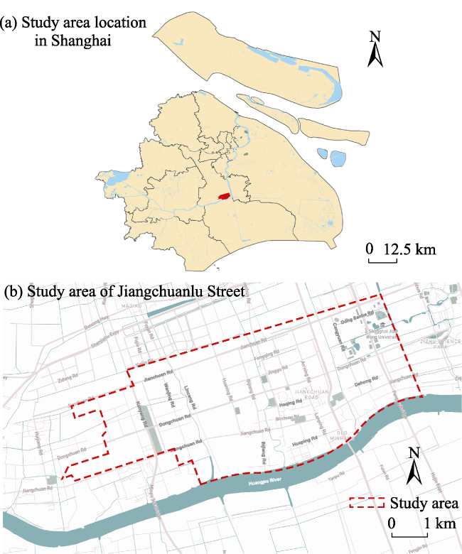
Fig. 2 The study area of Jiangchuanlu Street
The study area is located in Minhang District, where rain and heat coincide and rainfall is abundant, causing urban waterlogging and river flooding in recent years. Historically, typhoons have affected the study area an average of 2 times, up to a maximum of 5 times per year. In 2017, Minhang District experienced 17 heavy rain events during the flooding season, with a maximum of 84 mm of precipitation per hour. In recent years, the number of times the water level in the upper reaches of the Huangpu River has exceeded the 3.5-m warning line during the flooding season has increased. As a result, Minhang District promulgated a special emergency plan for flood and typhoon prevention in 2018 (Shanghai Municipal People’s Government, 2018). However, the storm surge disaster situation remains grim in the study area, and the threat of storm flooding will be even greater in the context of continued climate change and a rising sea-level in the future (Yin et al., 2013). Thus, it is imperative to carry out resilience planning in order to improve the stormwater resilience and disaster prevention capacity of Jiangchuanlu Street. Furthermore, many other places in China are facing similar threats, such as the exceptionally heavy rains that caused serious flood disasters in Henan Province, Hubei Province, and Shanxi Province in 2021. Thus, this study uses Jiangchuanlu Street as an example to provide a reference for many cities facing similar difficulties.
As another relevant issue in the study area, Shanghai experienced a severe outbreak of “COVID 19” in 2022, which lasted for more than 3 months, and the number of confirmed cases increased by as much as 30000 per day during the most severe period (Shanghai Municipal Health Commission, 2022). Jiangchuanlu Street has also been greatly affected by this crisis, as a number of confirmed patients were found on that street during the epidemic period. Areas such as the construction site dormitory of the Jianchuanlu Comprehensive Service Center have been listed as high-risk areas (Shanghai Municipal Health Commission, 2022). As a result, the daily life and mental health of residents in the surrounding residential areas have been greatly affected by isolation and restrictions. Therefore, the improvement of the community’s safety, health and epidemic response capacity are considered along with improvements in the stormwater resilience in the study area.
The data on elevation, land use, and drainage facilities in the study area are required in order to create the stormwater model and conduct a comprehensive risk assessment. As a result, the data sources for the Shanghai Jiangchuanlu Street study were consulted as follows: 1) Digital Elevation Model (DEM) data were obtained from the translation of topographic CAD elevation point information with an accuracy of 1 m; 2) Stormwater well and pipe network data were obtained from the translation of topographic CAD data; 3) Land use and sub-bedding surface status data were obtained from the manual translation of 2019 satellite images and the Shanghai Minhang District Master Plan and General Land Use Plan (2017-2035); and 4) The Shanghai Stormwater Intensity Formula and Rain Type Table was obtained from the Stormwater Intensity Formula and Design Rain Type Standard (Shanghai Local Standard) (Shanghai Water Authority, 2017).

3 Results

3.1 Stormwater model analysis

Stormwater model analysis starts with study area conceptualization, which means translating the study area into a site model that is suitable for calculations using mathematical software based on the current state of the site. The conceptualization of this study area was completed based on the ArcGIS platform, including pipe network data, sub-catchment delineation, and outfall determination. The elevation of the study area is generally between 2.2 and 9.3 m. For a plain area with such a small range in elevation, there is a large gap between the actual situation and the sub-catchment area when ArcGIS is used directly and automatically (Zuo and Cai, 2011). For this reason, we combined the elevation model (DEM), satellite map, and community drainage situation of the study area for the delineation. We conducted a hydrological analysis of the elevation model of the site in ArcGIS, and combined the catchment boundary with the current status of the community drainage facilities to initially delineate the sub-catchment area. Then, we interpreted the sub-catchment surface of the site through satellite images, and refined the division of the sub-catchment areas according to the demarcation of the surface. We then set the impermeable proportion of the sub-catchment area in the SWMM model according to the surface properties. Finally, we used the elevation model to estimate the elevations of the rainwater wells, thereby setting the drainage node elevation in the SWMM model. After conceptualization as shown in Fig. 3, the study area includes 6777 rainwater well nodes, 6840 pipes, 215 sub-catchments, and 23 outfalls, where the sub-catchment areas range from 0.55 ha to 92.63 ha.
Fig. 3 Conceptualization of the study area
The parameters of the SWMM model can be divided into measured parameters and empirical parameters. The measured parameters were obtained by using the ArcGIS platform to pre-process the land data and elevation data of the study area and to analyze the existing pipe network data, including sub-sink area parameters, pipe well parameters, pipe parameters, river parameters, etc. The empirical parameters were obtained by consulting the relevant literature (Zeng et al., 2017; Li et al., 2021b) and the SWMM operation manual for the purpose of experimental exploration, and the parameter values are shown in Table 2.
Table 2 Parameter values
Factor Parameter name Value
Impermeability manning factor N-Imperv 0.013
Permeability manning factor N-Perv 0.24
Impervious surface depression storage volume D-Imperv 2.5 mm
Permeable surface depression storage volume D-Perv 5 mm
Pipe roughness Roughness 0.013
Maximum infiltration rate MaxRate 103.8 mm h-1
Minimum infiltration rate MinRate 11.4 mm h-1
Attenuation coefficient Decay 8.46
We used the Shanghai storm design rain type, referring to “Storm intensity formula and design rain type standards (Shanghai local standards)”, to simulate the rainstorms in this study area. As shown in Table 3 and Fig. 4, we selected a rainfall calendar time of T=120 min case and a recurrence period of P=3 years rain type to simulate a general stormwater disaster for the site.
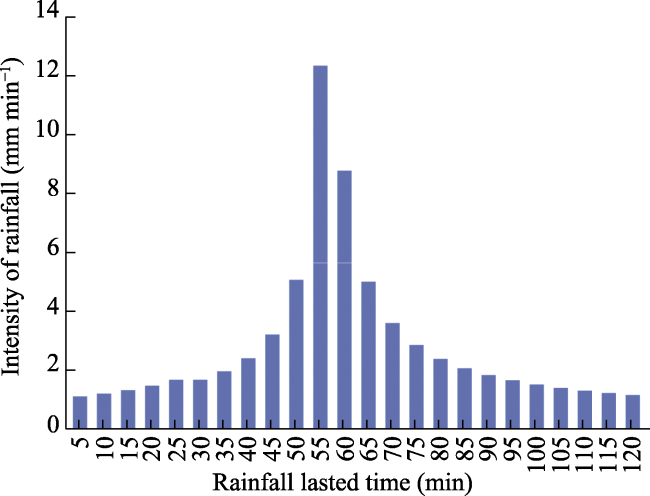
Table 3 Rain type of T=120 min, P=3 yr in Shanghai
T (min) 5 10 15 20 25 30 35 40 45 50 55 60
I (mm min-1) 1.107 1.202 1.319 1.470 1.672 1.958 2.400 3.186 5.036 12.233 8.696 4.974
T (min) 65 70 75 80 85 90 95 100 105 110 115 120
I (mm·min-1) 3.573 2.834 2.375 2.060 1.829 1.653 1.513 1.398 1.303 1.223 1.153 1.093

Note: T (min) represents rainfall duration, and I (mm min-1) is the instantaneous intensity of rainfall.

Fig. 4 Rain type diagram of T=120 min,P=3 yr in Shanghai
As shown in Fig. 5, overflow occurs at 15 nodes after the simulation results. The overflow points are concentrated on Huaning Road (Dongchuan Road-Jiangchuan Road), Lanping Road, Heqing Road, Dongsanhe Road and Cangyuan Road, while there are also individual distributions in Dehong Road, and near the western ends of Jiangchuan Road and Jianchuan Road. Thus, Huaning Road (Dongchuan Road - Jiangchuan Road), the intersection of Lanping Road and Heqing Road, East Three Rivers Road, and Cangyuan Road are the locations most prone to flooding.
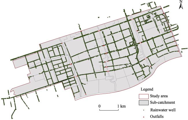
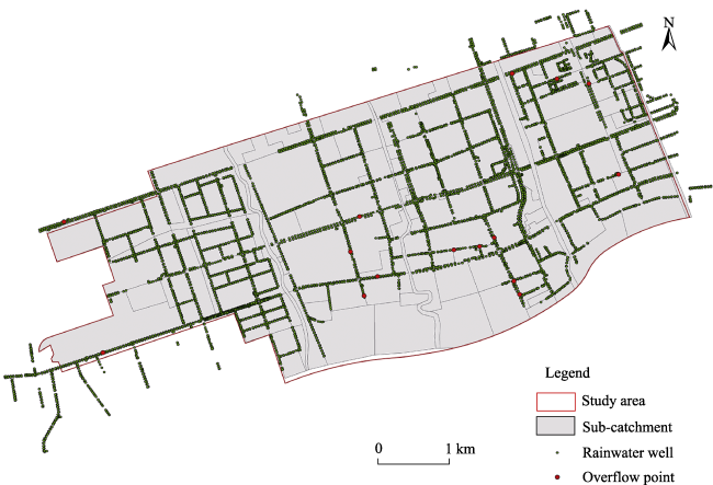
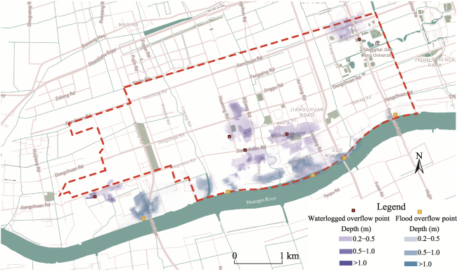
Fig. 5 Distribution of overflow points in SWMM model
We coupled the LISFLOOD-FP model with the SWMM model to simulate the stormwater disaster, and the key to the coupling was to input the nodal overflow data of the SWMM model into the LISFLOOD-FP model, in order to realize the two-dimensional simulation of storm inundation and obtain the inundation range and water depth. As Jiangchuanlu Street is located in the middle and upper reaches of Huangpu River, the risk of backflow of the Huangpu River caused by heavy rainfall should also be considered. As a result, the overflow points along the river were added based on the overflow points from the SWMM model analysis. Due to the lack of data on flood control facilities along the Huangpu River, the locations of the overflow points refer to the historical flooding situations, and the flow rate was set by taking the average value of the flow rates of the existing overflow points. Figure 6 shows the two-dimensional simulation at a typical moment when the inundation area of the study area is large. This figure shows that the water depths of more than 1 m in the study area are mainly concentrated along Huaning Road and Dongsanhe Road, which are the most serious areas of inundation; followed by Lanping Road and Heqing Road, where the inundation is extensive but with the water depths mostly below 1 m. In addition, the area along the river at the southern ends of Huaning Road and Lanping Road is also seriously flooded and inundated.
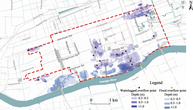
Fig. 6 Mapping of hydrological simulation of submergence depth

Note: The area without mapping in the figure is with simulated submersion depth of 0-0.2m.

3.2 Risk assessment

In this analysis, the sub-catchment area obtained after the conceptualization of the study area was used as the unit for risk assessment. The urban inundation extents and water depths obtained from the stormwater simulation were used as the basis for grading the hazards of causative factors, and the units affected by urban inundation were classified into four hazard classes (ADREM, 2012) as shown in Table 4. Meanwhile, the inundation losses determined by the nature and use of urban land were used as the criterion for judging the vulnerability of the disaster-bearing body, and the vulnerability levels of units affected by urban inundation were classified into four vulnerability classes as shown in Table 3. Ultimately, a risk matrix (Table 1) was used to make an comprehensive risk assessment of the study area, and the study area was divided into high risk, medium risk, low risk, and no risk areas for stormwater disasters according to the comprehensive risk levels (Table 5).
Table 4 Classification table of stormwater hazards and vulnerability of disaster-bearers
Stormwater hazards classification Vulnerability of disaster-bearers classification
Hazard level 3 2 1 0 Vulnerability level 3 2 1 0
Submergence depth >1.0 m 0.5-1.0 m 0.2-0.5 m 0-0.2 m Land use and population High property and population density, such as residential and commercial land Medium property and population density, such as industrial and warehouse land Low property and population density, such as parks and wetlands Property and population density close to zero, such as wasteland
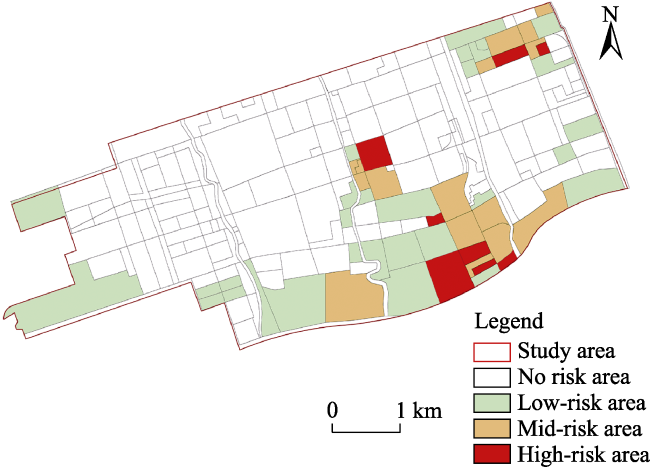
Table 5 Comprehensive risk level comparison table
Comprehensive risk assessment
Comprehensive risk level High-risk area Mid-risk area Low-risk area No risk area
Risk matrix result 6-9 3-4 1-2 0
As shown in Fig. 7, the areas with high stormwater risk in the study area are mostly concentrated on the south side along the river, mainly Lanping New Village, Gaohua New Village, and the communities around Lamping Market. This concentrated area is followed by the commercial housing residential area in the central part and the industrial park in the northeast corner of the study area, where the high-risk areas are Lido City and the dormitory complex of Shanghai Jiao Tong University. In addition, low-risk areas are also distributed among the factories on the west side of the study area and the campus on the east side.
Fig. 7 Comprehensive stormwater risk assessment of the study area

3.3 Eco-DRR application

Dissecting the complex built environment of a city and identifying potential disaster prevention spaces in an area is a prerequisite for the effective implementation of Eco-DRR measures. Bordered by the Huangpu River to the south, the study area of Jiangchuanlu Street is divided into four parts by three secondary rivers that run longitudinally through the site, with many horizontal and vertical river channels distributed in each part. As shown in Fig. 8, the west side of the site is mainly an industrial area with natural spaces such as strip green areas and horizontal river channels, which can be combined with wasteland and abandoned factory spaces for site micro-transformation. The central portion is mainly a residential area with many community parks, large parcels of unused vacant land on the north side, and natural spaces on both sides of the river, where new ecological wetlands and river corridors can be constructed; meanwhile, roadside trees and green space on both sides of the road, with more flexibility for spatial adjustment, can be combined with street green space and park green space to create ecological corridors. The eastern area is dominated by the campus, with a large number of campus green areas and lakes, as well as protective green areas on both sides of the highway. A large number of existing Eco-DRR spaces can be used to give full play to the study site’s disaster prevention potential and coordinate storage to relieve the stormwater pressure in other areas. There are some miniature undulations in the study area, and these depressed catchment areas identified through the elevated terrain model can be ecologically modified to fully utilize their ecological disaster risk reduction potential.
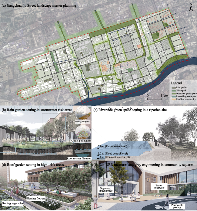
Fig. 8 Site mapping of where Eco-DRR can be implemented
Based on the results of the rainfall simulation and risk assessment, the selection of the priority areas for implementing Eco-DRR measures is based on ensuring the reasonableness and accuracy of the Eco-DRR implementation. The implementation should focus on the risk concentration areas of the south side along the river, the central commercial housing residential areas, and the northeastern corner industrial park. Thus, the riverside space along the north side of the Huangpu River was used to create public open green spaces to improve shoreline resilience; and the Eco-DRR spaces such as identified green and wasteland in these risk-intensive residential and industrial areas were used to create rain gardens and depressed green spaces to improve stormwater resilience (Fig. 9). Attention should also be paid to the high-risk areas such as Lanping New Village, Gaohua New Village, and the communities around Lanping Market, in which Eco-DRR measures such as roof gardens and community farms were implemented, assisting in the promotion of gray infrastructure and actively adopting other non-engineering measures to create resilient communities (Zhang et al., 2022). According to the spatial types and characteristics of disaster prevention space, the corresponding Eco-DRR measures and their stormwater storage functions are proposed in Table 6.
Fig. 9 The implementation of Eco-DRR measures in Jiangchuanlu Street
Table 6 Spatial types and Eco-DRR measures
Underlying surface Spatial type Eco-DRR measure Function

Permeable
underlayment
Urban park Stormwater park, artificial wetland Source reduction, flow stagnation, sink storage
Green space Rain gardens, depressed green areas, ecological ditches Source reduction, flow stagnation
Wasteland Woodland, stormwater park Source reduction, flow stagnation, sink storage

Water
River Ecological barge Source reduction, flow stagnation, confluence transfer
Lake Ecological protection and restoration Source reduction, flow stagnation, sink storage


Not permeable
underlayment
Community Resilient community, community farm, Community-based Natural Resource Management (CBNRM) Source reduction, flow stagnation, sink storage, emergency response capability improvement
Road Ecological ditch, depressed green space Source reduction, flow stagnation, confluence transfer
Green building Green roof, vertical greening rainwater collection system Source reduction, flow stagnation
Square/parking Green space, water reservoir Source reduction, flow stagnation

3.4 Ecological infrastructure construction

Given the characteristics of the Eco-DRR space distribution on Jiangchuanlu Street, the hydrological simulation results should be used to reorganize the hydrological process of “source-flow-sink” and construct an ecological infrastructure system to form the ecological substrate of the sponge city, in order to reduce the urban risk under the protection of the ecological substrate. The results of the stormwater simulation show that Jiangchuanlu is seriously affected by storm surges, with a large volume of rainfall-runoff and limited drainage capacity. As a result, there are overflow points in some sections of the street, which can easily form multiple floods in a short time, and this poses a severe risk of river backflow along the river. Referring to the results of the stormwater simulation and the characteristics of Eco-DRR space distribution in the study area, four ecological infrastructure construction methods are proposed.
(1) Protect the ecological functions of Huangpu River and the woodland to be built in the north, in order to protect the whole area as an ecological skeleton.
(2) Ecologically treat the river waterfront shoreline and strip green areas that run through the study area, in order to coordinate the storage of the whole area as a first-class corridor.
(3) Carry out the ecological transformations on Huanning Road, Lamping Road, and Heqing Road, where overflow points are concentrated, in order to create a green street space as a secondary corridor to reduce the severe stormwater risks in the central and southern parts of the study area.
(4) Make full use of the widely distributed Eco-DRR space, and implement Eco-DRR measures to reduce in situ sources of stagnant flood storage, so they can act as ecological nodes for localized storage.
The final ecological infrastructure is formed with the Huangpu River and the northern woodland as the regional ecological skeleton; river ecological corridors, strip green areas and ecological streets as the ecological corridors; and small green areas, pocket parks, and rain gardens that implement Eco-DRR measures as the ecological nodes. In addition to the ecological infrastructure, 15 island units (ranging from 1-2 km2) are divided into a combination of “city-island structure + safety and health units”, which provides a way to reduce the size of water catchment units and disperse the regional water catchment pressure. These island-shaped units are surrounded by a green space system to create a quality living environment for the units, thus creating safety and health units. In addition to reducing the risk of rainfall and flooding, the units will also help the area to cope with the COVID-19 pneumonia epidemic, giving them the dual functions of “community living circle” and “public health unit”, and forming a “living circle in peacetime and epidemic prevention circle in wartime” (Chen and Cha, 2021). In this way, the final ecological infrastructure can combine the functions of stormwater storage and site services, and establish a resilient emergency system (Fig. 10).
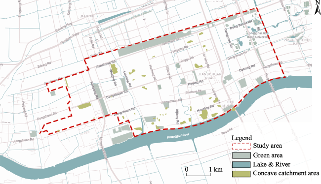
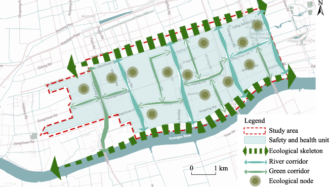
Fig.10 Ecological infrastructure system of the study area

4 Discussion

As shown in Fig. 11, the stormwater model based on LISFLOOD-FP and SWMM was used in this study to simulate the flood disasters of Jiangchuanlu Street. This approach is widely used in recent risk assessment works (Zeng et al., 2017; Li et al., 2021b), but is still not commonly used in the construction of sponge cities (Zhu and Weng, 2021; Hua et al., 2022). In addition to the simulation results, the population and property conditions of the site were combined, and a comprehensive risk assessment was conducted through the risk matrix, which is frequently used in natural disaster risk assessments (Gai et al., 2011; Liu et al., 2011). Overall, this stormwater risk assessment method (Fig. 11) uses digital simulation technology, while considering the hazards of the causative factors and the vulnerability of the disaster-bearing body. The assessment results can provide effective support for the implementation of Eco-DRR. However, the assessment results could be made more scientific and reliable by considering the exposure of people and property in the hazard zones and the city’s stormwater adaptive capacity (Zhai, 2018; Sudmeier-Rieux et al., 2019). Furthermore, machine learning models could be used for more accurate flood risk assessments in cases where enough data is available (Chen et al., 2021).
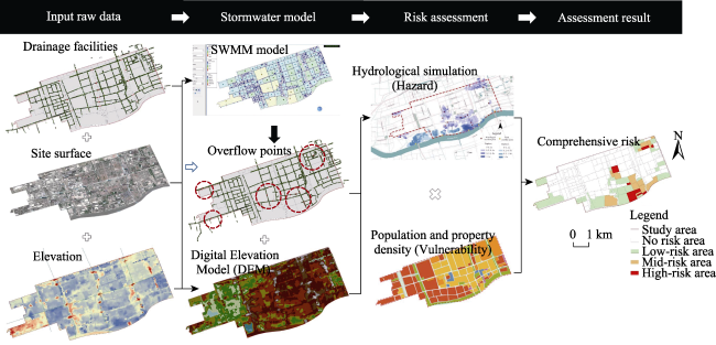
Fig. 11 Stormwater risk assessment process
Quantifying the improvement effect of stormwater resilience in the current sponge city scheme is challenging (Zhu and Weng, 2021; Hua et al., 2022). One aim of this study was to take advantage of the stormwater model to verify the effect of the scheme. After the implementation of Eco-DRR measures, the planning results of the study area were conceptualized in the ArcGIS platform, and the same model parameters and rain types were used in the stormwater model for analysis. The calibration results (Fig. 12) showed two key improvements: (i) After the implementation of the scheme, the number of inundation overflow points generated in the study area during heavy rainfall was significantly reduced, from 15 to 5; and (ii) The inundation extent and depth of the study area were both significantly reduced under the same rainstorm conditions. These results indicated that Eco-DRR has great effects in improving urban stormwater resilience and reducing flooding risk. Eco-DRR should be more widely used to enhance the resilience of cities to floods and heavy rains, as well as other natural disasters such as high temperature, drought, and fire (Tong and Bao, 2022). As further improvements, more resilience indicators can be compared to make the calibration more scientific, and the stormwater model can also be used to compare the effects of multiple planning schemes to improve the rationality of decisions (Pan et al., 2021).
Fig. 12 Hydrological simulation of submergence after Eco-DDR implementation

Note: The area without mapping in the figure is with simulated submersion depth of 0-0.2m.

This study involved building an ecological infrastructure network as the boundary of the units, and establishing safety and health units to prevent and respond to public health emergencies such as the “COVID 19” pneumonia epidemic. However, the division of the safety and health units is not only related to the boundary, but also needs to consider the community, population, facilities and other features within the unit (Qian et al., 2020). Timely and effective control of the spread of infectious diseases will also require taking the safety and health unit as the core and carrying out zoning control. At the same time, with human health as the center, the overall health environment quality of the community and the layout of service facilities should also be improved in order to achieve peacetime and wartime integration (Chen and Cha, 2021).

5 Conclusions

In the context of continuous climate change and urban expansion, cities are facing increasingly severe stormwater problems. This study combined stormwater simulation and Eco-DRR theory and proposed an approach to improve the stormwater resilience of sponge cities, which is important for the resilient development of cities in areas of high stormwater vulnerability. Taking Jiangchuanlu Street as an example to implement this approach, the stormwater model was used to verify the effect of the approach. The results showed that the stormwater resilience enhancement approach based on Eco-DRR can effectively alleviate the flood risk of Jiangchuanlu Street. At the same time, the safety and health units were built based on the ecological substrate, considering the daily health of residents and the emergency response to the epidemic. Thus, this study can provide a theoretical reference for the planning and construction of safe and resilient cities. In addition, the application of Eco-DRR theory to sponge city practice in this case study suggests that it can be applied to other urban resilience construction fields as well, to make greater contributions to comprehensive urban disaster prevention.
[1]
Academy of Disaster Reduction and Emergency Management ADREM. 2012. Grading methods of natural disaster risk. Beijing, China: Ministry of Civil Affairs of the People’s Republic of China.

[2]
Adikari Y, Yoshitani J. 2009. Global trends in water-related disasters: An insight for policymakers. Tokyo, Japan: Savas Printing.

[3]
Chen Y, Cha J. 2021. Analysis on urban design from the perspective of safety and resilience: A case study of the Changsha exhibition area urban design. Contemporary Architecture, 2021(12): 48-51. (in Chinese)

[4]
Chen J L, Huang G R, Chen W J. 2021. Towards better flood risk management: assessing flood risk and investigating the potential mechanism based on machine learning models. Journal of Environmental Management, 293(1): 112810. DOI: 10.1016/j.jenvman.2021.112810.

[5]
Doswald N, Estrella M. 2015. Promoting ecosystems for disaster risk reduction and climate change adaptation. Nairobi,Kenya: United Nations Environment Programme.

[6]
Gai C C, Weng W G, Yuan H G. 2011. Multi-hazard risk assessment using GIS in urban areas. Journal of Tsinghua University (Science and Technology), 51(5): 627-631. (in Chinese)

[7]
Hartmann T. 2012. Wicked problems and clumsy solutions: Planning as expectation management. Planning Theory, 11(3): 242-256.

DOI

[8]
Hua C, Gao Q, Li Y H. 2022. Research on urban green stormwater infrastructure planning under the guidance of ecological resilience: Theoretical framework and technical path. Architecture & Culture, (2): 171-173. (in Chinese)

[9]
Li P, Xu Z X, Zhao G, et al. 2021a. Simulation of urban rainstorm waterlogging processes based on SWMM and LISFLOOD-FP models: Case study in Jinan City. South-to-North Water Transfers and Water Science & Technology, 19(6): 1083-1092.

[10]
Li W, Gao J B, Qi X Y, et al. 2021b. Numerical simulation of urban waterlogging and risk analysis based on a coupled model. Technical Supervision in Water Resources, 29(12): 56-61. (in Chinese)

[11]
Li Y H, Zou L, Li L, et al. 2022. Improving urban stormwater resilience by promoting sponge city construction system. Journal of Human Settlements in West China, 37(1): 22-26.

[12]
Liu S, Chen N J. 2019. Mechanism and promotion of green infrastructure’s hydrological regulation service. Landscape Architecture, 26(2): 82-87. (in Chinese)

[13]
Liu Y, Wu S H, Xu Z C, et al. 2011. Methodology for assessment and classification of natural disaster risk: A case study on seismic disaster in Shanxi Province. Geography Research, 30(2): 195-208. (in Chinese)

[14]
Pan H X, Dai S Z, Zhao Y J, et al. 2021. Symposium on urban resilience and spatial planning in response to climate change. Urban Planning Forum, (5): 1-10. (in Chinese)

[15]
Qian Z L, Wang Z, Qiu Z, et al. 2020. Construction system and strategy of “safety and health unit” in urban and rural areas: based on a response mechanism of “prevention-adaption-utilization” for coping with plagues and disasters. City Planning Review, 44(3): 25-30. (in Chinese)

[16]
Shanghai Municipal People’s Government. 2018. Special emergency plan for flood and typhoon prevention in Minhang District. http://smljl.swj.sh.gov.cn/ya/14.pdf. Viewed on 2022-08-15.

[17]
Shanghai Municipal Health Commission. 2022. Shanghai reported on the prevention and control of “COVID 19”. https://wsjkw.sh.gov.cn/xwfbh/index_4.html. Viewed on 2022-08-15.

[18]
Shanghai Water Authority. 2017. Standard of rainstorm intensity formula and design rainstorm distribution, China: Shanghai Municipal Bureau of Quality and Technical Supervision.

[19]
She N, Xie Y X, Li D H. 2021. Reflections and suggestions on China’s sponge city construction. Landscape Architecture Frontiers, 9(4): 82-91. (in Chinese)

DOI

[20]
Sudmeier-rieux K, Estrella M. 2013. Ecosystem-based disaster risk reduction (Eco-DRR): An overview. In: Fabrice G R, Sudmeier-rieux K, Estrella M (eds.). The role of ecosystems in disaster risk reduction. Tokyo, Japan: United Nations University Press.

[21]
Sudmeier-rieux K, Nehren U M, Sandholz S, et al. 2019. Planning tools for ecoystem-based disaster risk reduction and adaptation. Nairobi, Kenya: United Nations Environment Programme.

[22]
Tong T, Bao Q X. 2022. The application of ecosystem-based adaptation and disaster risk reduction in foreign urban climate planning. Landscape Architecture, 29(1): 102-107.

[23]
Xu H J. 2021. Research on urban rain and flood simulation modeling method based on SWMM. Water Resources Planning and Design, (9): 44-49, 97.

[24]
Yin J, Yin Z E, Yu D P, et al. 2013. Hazard analysis of extreme storm flooding in the context of sea level rise: A case study of Huangpu River Basin. Geography Research, 32(12): 2215-2221. (in Chinese)

[25]
Yu K J, Gong Y. 2021. Exploration on ecological restoration model for the improvement of ecosystem services of Yellow River floodplains—A case study of Zhengzhou Yellow River Floodplain Park planning and design. Landscape Architecture Frontier, 9(3): 86-97.

[26]
Yuan X Z, Du C L, Yuan J. 2017. Multi-functional dike-pond system adaptive to water level change: Application of pond-based ecological wisdom in ecological restoration of the hydro-fluctuation belt of the Three Gorges Reservoir. Landscape Architecture Frontiers, 5(1): 8-21. (in Chinese)

DOI

[27]
Zeng Z Y, Wang Z L, Wu X S, et al. 2017. Rainstorm waterlogging simulations based on SWMM and LISFLOOD models. Journal of Hydroelectric Engineering, 36(5): 68-77. (in Chinese)

[28]
Zhai Y F. 2018. Research on comprehensive urban disaster prevention planning under the concept of resilient city. Annual National Planning Conference 2018, November 24-26, 2018. Hangzhou, China: Urban Planning Society of China. (in Chinese)

[29]
Zhang L W. 2021. Positioning, concept and strategy of China’s sponge city: Review and interpretation of document No.75 [2105] of State Council. Water & Wastewater Engineering, 57(10): 1-8. (in Chinese)

[30]
Zhang Q, Xue S S, Zou C D. 2022. A community resilience evaluation and optimization strategy based on stormwater management. Journal of Resources and Ecology, 13(3): 360-370.

DOI

[31]
Zhi G, Liao Z, Tian W, et al. 2020. Urban flood risk assessment and analysis with a 3D visualization method coupling the PP-PSO algorithm and building data. Journal of Environmental Management, 268: 110521. DOI: 10.1016/j.jenvman.2020.110521.

[32]
Zhou H, Lin M, Chen J C. 2020. Simulation and benefit evaluation of urban rain flood model based on GIS and SWMM: A case study of Maluan Bay area in Amoy. Modern Urban Research, (12): 112-119. (in Chinese)

[33]
Zhu X B, Weng Y C. 2021. Spatial pattern optimization of green infrastructure in Pazhou Island in Guangzhou from the perspective of flood resilience. Guangdong Landscape Architecture, 43(1): 8-12. (in Chinese)

[34]
Zuo J J, Cai Y L. 2011. An automated watershed delineations approach for plain river network regions: A case study in Shanghai. Advances in Water Science, 22(3): 337-343. (in Chinese)

Outlines

/