Animal Ecology

MaxEnt Modeling for Predicting Suitable Habitats of Snow Leopard (Panthera uncia) in the Mid-Eastern Tianshan Mountains

  • GONG Jianhui , 1, 2 ,
  • LI Yibin 2 ,
  • WANG Ruifen 3 ,
  • YU Chenxing 2 ,
  • FAN Jian 2 ,
  • SHI Kun , 1, 2, *
Expand
  • 1. The Wildlife Institute, School of Ecology & Nature Conservation, Beijing Forestry University, Beijing 100083, China
  • 2. Eco-Bridge Continental, Beijing 100085, China
  • 3. Eastern Tianshan State Forestry Administration of Xinjiang Uygur Autonomous Region, Uygur 830001, China
*SHI Kun, E-mail:

GONG Jianhui, E-mail:

Received date: 2023-03-14

  Accepted date: 2023-05-16

  Online published: 2023-08-02

Supported by

The Qilian Mountains, Eastern TianShan Snow Leopard Specialized Survey(2017092302)

The Eastern Tien Shan Snow Leopard Specialized Survey(2018HXFWBHQ-SK-01)

The Fundamental Investigation of Wild Animal and Plant Resources of Eastern Tianshan State Forestry Administration(XJSZG2022-102)

Abstract

Studies of species habitat and distribution patterns are an important prerequisite for conservation efforts, and habitat quality and integrity play a crucial role in the population health and recovery of endangered species. This is especially applicable to the snow leopard, a top predator that is key to highland mountain ecosystems. In this study, 112 valid snow leopard distribution loci obtained by infrared camera surveys in the mid-eastern Tianshan, Xinjiang were examined. Combined with 12 characteristic environmental variables, the maximum entropy model (MaxEnt) and GIS techniques were used to analyse the potential distribution areas and suitable habitats of snow leopards in the mid-eastern Tianshan. The results showed that the total area of suitable habitat for snow leopards in the mid-eastern Tianshan was 15919 km2, and the most suitable habitat was mainly concentrated in a western patch around Wusu, Hutubi, and the southern mountains of Urumqi. The results of a Jackknife analysis showed that land cover type, the daily difference in average temperature, isothermality, slope, and altitude were important factors affecting the distribution of snow leopards. Deciduous coniferous forests, grasslands, and bare rock areas with sparse vegetation at altitudes from 2500 m to 5000 m are the areas where snow leopards have a higher probability of occurrence in the mid-eastern Tianshan. This study determined the key distribution areas of snow leopards and provides a scientific basis for establishing key areas for snow leopard monitoring and protection in the mid-eastern Tianshan.

Cite this article

GONG Jianhui , LI Yibin , WANG Ruifen , YU Chenxing , FAN Jian , SHI Kun . MaxEnt Modeling for Predicting Suitable Habitats of Snow Leopard (Panthera uncia) in the Mid-Eastern Tianshan Mountains[J]. Journal of Resources and Ecology, 2023 , 14(5) : 1075 -1085 . DOI: 10.5814/j.issn.1674-764x.2023.05.018

1 Introduction

The snow leopard is a large cat found only in the alpine regions of Central Asia, and it is the flagship and umbrella species of the Central Asian alpine ecosystem. The snow leopard is defined as Vulnerable by the IUCN Red List and classified as a national-level protected animal in China. It is usually active in rugged mountainous areas at high altitudes (Xu et al., 2006; Ma et al., 2021), mainly in the western mountain ranges such as the Himalayas, and the Tianshan and Altai Mountains in China. The Tianshan Mountains are one of the core habitats of the snow leopard distribution in Xinjiang, China (Hussain, 2003). Habitat is the living environment on which a species or group depends, and suitable habitat can contribute to the sustainability of a species (Tilman et al., 1994; Debinski and Holt, 2000). Consequently, habitat assessments and conservation efforts are essential for protecting individual species and the ecosystem as a whole (Fahrig, 1997; Pearson et al., 2007; Bai et al., 2018). In its 2013 conservation action plan, the Chinese Forestry Administration stated that prey reduction, habitat encroachment due to grazing, pasture degradation, climate change, illegal mining, road construction, and lack of protection are the main threats to the snow leopard in China. Therefore, habitat conservation is a long-term and critical task in snow leopard conservation (Forrest et al., 2012; Li et al., 2019).
Since the first systematic and scientific snow leopard survey work conducted by Liao and Dr George Schaller in the Qinghai, Gansu, and Xinjiang regions of China in the 1980s, snow leopard research in China has gradually advanced. This particularly applies to the Qilian Mountains (Alexander et al., 2016), Sanjiangyuan, Tibet, and Sichuan regions. Studies have estimated snow leopard habitat and population density, and accurate data and studies on local snow leopard resources are now available. Multiple factors have been shown to influence snow leopard habitat selection. The results from studies in the Qilian Mountains of Gansu Province show that prey and altitude are the main influences on snow leopard habitat selection in the Qilian Mountains region (Alexander et al., 2016). Therefore, the suitable habitat for snow leopards in the Qilian Mountains region will be further reduced along with the trend of global warming and the increasing snow line. The results of a study in the Qomolangma National Nature Reserve in Tibet showed that the main factors for snow leopard habitat selection in the Qomolangma region include temperature, ruggedness, altitude, and annual precipitation (Bai et al., 2018). The results of studies in the Xinjiang region showed that snow leopards are selective for characteristics such as altitude, topography, vegetation type, grazing status, and habitat flatness (Xu et al., 2006).
The Tianshan Mountains are one of the seven major mountain ranges in the world. Their unique habitat composition and complex mountain alignment have created diverse natural landscape zones and rich biological community compositions. Large gaps in the research on snow leopards in the Tianshan Mountains still remain, with studies on snow leopard habitat limited to the main peak of the western Tianshan, Tomur Peak, and central Tianshan (Xu et al., 2011; Ma et al., 2021). Xu et al. (2006) tentatively concluded that the main factors influencing snow leopard habitat selection in the Tianshan Mountains are ruggedness and vegetation cover, by means of trace surveys and other methods. Tomur Peak in the western Tianshan may be the hotspot for snow leopards in Tianshan, but that area is covered with large glaciers, and the glacier surface is not suitable as a habitat for snow leopards. Their main prey inhabits about 70% of the total area, and the actual area of suitable habitat for both snow leopards and their prey in western Tianshan is very narrow. Furthermore, the population density of snow leopards is predicted to be about 2-3 individuals per km2 (Xu et al., 2011). In previous studies of snow leopards in the area from Usu to Banfanggou, ruggedness and elevation were found to be the main factors influencing snow leopard distribution in the central Tianshan, with secondary factors being the distance from the railroad and slope direction (Ma et al., 2021). So far there has been no systematic snow leopard habitat analysis of the eastern Tianshan.
In this study the maximum entropy approach (MaxEnt) model was used to predict the potential spatial distribution areas and suitable habitats of snow leopards in the mid-eastern Tianshan. Trace surveys and infrared camera technology were used to further improve the research data on snow leopards and their habitats in the mid-eastern Tianshan, and provide a scientific basis to help relevant departments formulate policies to protect snow leopard habitats. MaxEnt is one of the main species distribution models for habitat analysis (Phillips et al., 2006; Harte and Newman, 2014). It is a geographically-scaled spatial distribution model for species based on the maximum entropy theory, and it has been widely used in recent years for predicting the potential distributions of species by combining relevant environmental variables. As the MaxEnt model performs well even with small sample sizes (Syfert et al., 2013), it is suitable for predicting the habitats of endangered species and species of economic value. By analysing the suitability of snow leopard habitat in order to estimate the distribution range of snow leopards and predict future changes in snow leopard habitat, this study can provide basic information in support of wildlife conservation and habitat protection work, and thus prevent the future destruction of habitat through further development (Alexander et al., 2016).

2 Research methodology

2.1 Study area

Xinjiang Tianshan Mountain is located in Xinjiang Urumqi Autonomous Region in the north-west of China. It has a length of about 1700 km, a geographical coordinate range of 83°03′08″-95°46′42″E and 42°49′54″-44°32′25″N, and covers an area of over 5.7×10⁵ km2, thereby accounting for about one-third of the area of Xinjiang. The Tianshan Mountains are located on the Eurasian continent and have a vast area, great elevation range, large distance from the ocean, and low air humidity. These characteristics form a more typical temperate continental arid semi-arid climate. The overall mountain system precipitation distribution is uneven, with more precipitation on the northern slope than the southern slope, and the annual precipitation on the northern slope of the Tianshan Mountains can reach 500-700 mm. Because of the length of the mountain system, large altitude difference, and variations in soil types, the natural landscape zone of the Tianshan Mountains is basically vertical.
The Tianshan Mountains are the core habitat of snow leopards in the Xinjiang region and connect many countries within the snow leopard range. This study covers a total area of 3975 km2 in the mid-eastern part of the Tianshan Mountains, involving 11 forested areas under the jurisdiction of the Tianshan Eastern State-owned Forestry Administration (TEAF) in the following branches: Wusu, Shawan, Manasi, Hutubi, South mountain of Urumqi, Banfanggou, Miquan, Jimusaer, Qitai, Mulei, and Kumul. The latter five branches have not conducted comprehensive and systematic snow leopard surveys thus far.
Considering the large east-west span involved in this study, the survey area was divided into three geographic patches according to the mid-eastern Tianshan alignment and the urban barrier: western patch (forested mountain area around Wusu-Banfanggou), central patch (forested mountain area around Miquan-Mulei), and eastern patch (forested mountain area around Kumul).

2.2 Data acquisition and processing

From November 2018 to June 2019 and from October 2021 to May 2022, 97 and 159 grids were respectively delineated in the forest area under the jurisdiction of the Tianshan Eastern State-owned Forestry Administration in the mid-eastern Tianshan (Fig. 1). Each grid had an area of 25 km2, with 90 and 352 infrared cameras deployed in the two survey periods, respectively, and filming was performed without interruption. A total of 351 infrared cameras were recovered and the total number of effective filming days was 72823 days. After eliminating snow leopard occurrence loci without GPS records and loci separated by distances of less than 500 m, a total of 194 valid snow leopard occurrence loci were obtained (Figs. 2-3). These events span altitudes of 1180-3606 m and seven land cover types in study area.
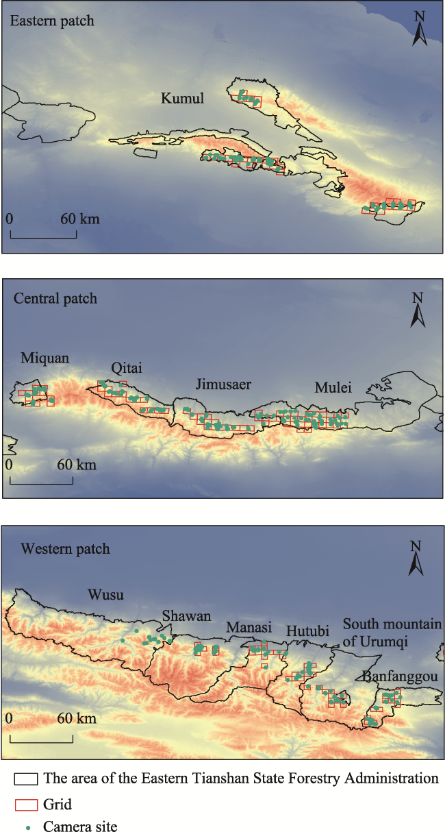
Fig. 1 Grid planning and camera arrangement
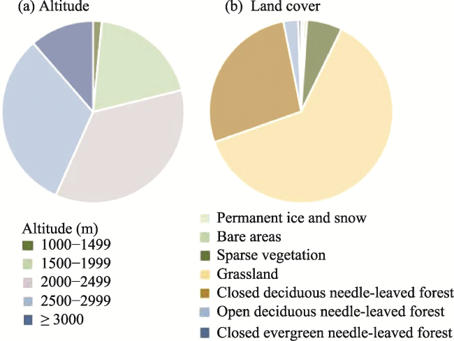
Fig. 2 Altitude and land cover share of the 194 snow leopard occurrence events
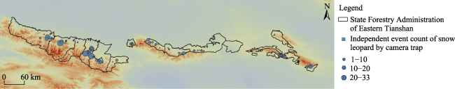
Fig. 3 Map of the snow leopard locations recorded by infrared cameras in the survey area

2.3 Model selection and use

Based on the 194 snow leopard loci, this study selected model variables for topography (altitude, ruggedness, slope, aspect, distance from rivers), land cover type, human disturbance (distance from roads, distance from railways, human footprint index), and 19 climatic factors (Bio1-Bio19), for a total of 28 environmental variables in four environmental factor categories. These factors were used as variables in the MaxEnt model, and have been shown in previous studies to potentially influence the distribution of snow leopards (Xu et al., 2006; Athreya et al., 2013; Morrison et al., 2014; Bai et al., 2018; Xiao et al., 2019). According to the data from a Xinjiang climate study, the driest season in the study area is not the coldest season, therefore Bio9 (Mean temperature of driest quarter) and Bio11 (Mean temperature of coldest quarter) are not correlated (Huang et al., 2020). Elevation, ruggedness, slope, and slope direction were based on extractions done using ArcGIS by downloading a 30 m resolution digital elevation model (DEM) from the National Aeronautics and Space Administration
(NASA). Land cover type was obtained from the Global 30 m×30 m Land Cover Dataset 2020 of the Institute of Space and Space Information Innovation, Chinese Academy of Sciences (Zhang et al., 2021). The vegetation normalized index (NDVI) data were obtained from NASA. The raster files of 19 bioclimatic factors were obtained from the World Meteorological Database, and the climate variables were extracted from ArcGIS as the model habitat variables. The distance from major roads and distance from water sources were downloaded from the 1:100000 vector map of the National Bureau of Surveying, Mapping and Geographic Information website and obtained with the extraction of Euclidean distance in ArcGIS. Finally, the Human Footprint Index (HFI) was obtained from the NASA Socioeconomic Data and Applications Center database by normalizing the Human Impact Index (HII) and combining data from four categories: population density, land use change, accessibility, and power infrastructure (Sanderson et al., 2002).
The Pearson test was performed on the 28 environmental variables using ArcGIS software to avoid any multicollinearity among the environmental variables which would affect the prediction results. The 12 environmental variables with the lowest correlations were selected for model construction (Table 1). All environmental data were bounded uniformly in ArcGIS, and ASC raster files with an image element size of 500 m, row number, and projection coordinate system were set for the subsequent MaxEnt model prediction. The range of 0.1-4.0 was chosen to represent an interval of 0.1 for 40 levels, and 29 combinations of the following five features were selected to construct a total of 1160 models: linear-L, quadratic-Q, hinge-H, product-P, and threshold-T. The complexity of the models under various parameters was analysed using the ENMtools tool, and the model with a quadratic type and a regularization multiplier of 0.4 was finally selected as the optimal model. The environmental variable data and snow leopard distribution data were imported into the MaxEnt 3.4 software, and 75% of the snow leopard distribution points were randomly selected as the training set. The remaining 25% of the distribution points were used as the test set for model testing, and the model run was repeated 50 times (Seyed et al., 2018). The accuracy of the model prediction was assessed by the area enclosed by the Receiver Operating Characteristic (ROC) curve and the horizontal axis.

2.4 Habitat suitability classification system

The model output ASCII file was imported into ArcGIS Pro and converted into floating point raster data. The threshold value when the sum of specificity and sensitivity of the model training data reached its maximum was 0.2023, which was used as the cut-off value between areas that were suitable and unsuitable as snow leopard habitat. Considering the poor differentiation of habitat suitability, this study further divided the habitat suitability map into four classes using equal intervals of 0-0.2023 as unsuitable habitat, 0.2023-0.40 as poor habitat, 0.40-0.70 as good habitat, and 0.70-1.0 as excellent habitat. Through this process, the habitat suitability distribution of snow leopards in the mid-eastern Tianshan area was obtained.

3 Results

3.1 Evaluation of model accuracy and importance of each environmental variable

This study predicted the habitat suitability for snow leopards in the mid-eastern Tianshan Mountains by establishing a MaxEnt species distribution model. The results of the model ROC curve (Fig. 4) show a training AUC value of 0.956 and a test AUC value of 0.956, with an average AUC of 0.951. These values indicate that the MaxEnt model predicted the hotspot distribution area of the snow leopard to a good level with high confidence.
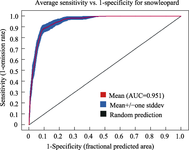
Fig. 4 Predictive effectiveness ROC curve for the model

3.2 Importance of the impact factors and their relationships with snow leopard distribution

The Jackknife cut method was used to analyse the importance of each environmental variable in predicting the potential distribution area of snow leopards (Fig. 5). The results showed that land cover type had the greatest influence on snow leopard distribution, followed sequentially by mean daily difference in temperature, isothermality, slope, and elevation, with the last three factors differing from each other only slightly. These results show that topographic variables and bioclimatic variables have comparable effects on snow leopard distribution, with relatively small contributions from human-influenced variables. Percent contribution and displacement importance are two other metrics that can be used in MAXENT to analyse the importance of influencing factors. Percent contribution refers to the contribution of each influencing factor to habitat selection during the training process of the MaxEnt model; while displacement importance is the degree of reduction in the AUC values obtained from model simulations after the random replacement of climate factors at sample sites. Based on these two values (Table 1), the five parameters that contributed the most to the model are land cover (53.8%), mean daily difference in temperature (Bio2) (14.4%), isothermality (Bio3) (9.4%), driest seasonal rainfall (Bio17) (6.5%), and elevation (4.5%). The five most important parameters in determining the selection of suitable habitat for snow leopards are mean daily difference in temperature (Bio2) (42.4), isothermality (Bio3) (20.7), seasonality of precipitation (Bio15) (7.9), driest quarter rainfall (Bio17) (7.2), and elevation (7.1).
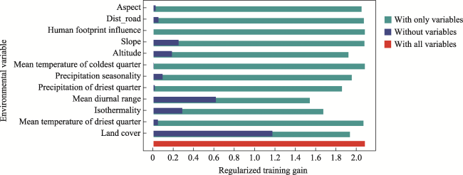
Fig. 5 Jackknife test for variable environmental characteristics of the MaxEnt model
Table 1 Percentage contributions and importance values of the environmental variables
Environment variable Description Contribution rate (%) Displacement importance (%)
Land cover Land cover type 53.8 6.7
Bio2 Mean diurnal range (mean of monthly (max temp-min temp)) 14.4 42.4
Bio3 Isothermality (Bio2/Bio7) (×100) 9.4 20.7
Bio17 Precipitation of driest quarter 6.5 7.2
Altitude Altitude 4.5 7.1
Bio15 Precipitation seasonality (coefficient of variation) 4.0 7.9
Bio9 Mean temperature of driest quarter 2.5 6.5
Bio11 Mean temperature of coldest quarter 1.7 0.2
Dist_road Distance to the roads 1.6 1.0
Aspect Aspect 1.4 0.3
Slope Slope 0.2 0.1
HFI Human footprint influence 0 0
The results of the Jackknife cut method and the contributions of environmental factors (Table 1) show that land cover type is the most important factor in selecting a habitat for snow leopards. The response curves of the factors influencing the habitat suitability for snow leopards in the mid-eastern Tianshan show that the areas with a high probability of snow leopard occurrence are the following habitats at altitudes from 2500 m to 5000 m: deciduous needle-leaved forests (81 Open deciduous needle-leaved forest, response value ~0.7), grassland (130 Grassland, response value ~0.48), and sparse vegetation (150 Sparse vegetation, response value ~0.48). Bioclimatic factors also affect the distribution of snow leopards. Table 1 shows that mean daily temperature difference, isothermality, and driest seasonal precipitation are the main bioclimatic factors affecting snow leopard habitat. Mean daily difference and isothermality contributed the most, and the areas with the highest probability of snow leopard occurrence were those with a mean daily difference of less than 10 ℃ and annual isothermality values ranging from 30-37 ℃ (Fig. 6).
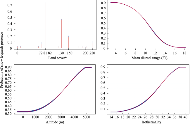
Fig. 6 Response curves of the major factors influencing the habitat suitability for snow leopards in the mid-eastern Tianshan

Note: * Meaning of land cover values: 72 means closed evergreen needle-leaved forest; 81 means open deciduous needle-leaved forest; 82 means closed deciduous needle-leaved forest; 130 means grassland; 150 means sparse vegetation; 200 means bare areas; and 220 means permanent ice and snow.

3.3 Habitat suitability for snow leopards

The model results predicted that the suitable habitat area for snow leopards in the mid-eastern Tianshan forest area covers about 15919 km2, accounting for 51.1% of the total area under the jurisdiction. Among the suitability levels, the highly suitable habitat is mostly located in the central part of the mid-eastern Tianshan with a total area of 1836 km2, the moderately suitable area is 6738 km2, and the low suitability area is 7345 km2 (Table 2). Considering the mountain range orientation and topography of the survey area, and taking Miquan as the boundary point of the mid-eastern Tianshan, we can conclude that the suitable habitat area of snow leopards in the western part of the mid-eastern Tianshan (Wusu, South mountain of Urumqi, Shawan, Hutubi, Manasi, and Banfanggou) is more suitable than in the eastern part (Miquan, Jimusaer, Qitai, Mulei, and Hami). The South Mountain of Urumq and Hutubi have 400 km2 of highly suitable habitat, which represents the most widely distributed area of highly suitable habitat in the mid-eastern Tianshan (Fig. 7).
Table 2 The areas of each potential habitat suitability class for snow leopards in each sub-survey area in the mid-eastern Tianshan
Sub-survey
area
Excellent habitat
(km2)
Good habitat
(km2)
Poor habitat
(km2)
Total
(km2)
Wusu 242.8 1186.0 1040.3 2469.2
South mountain of Urumqi 407.5 897.5 853.8 2158.8
Mulei 58.4 792.6 1306.4 2157.4
Shawan 271.0 857.3 682.8 1811.1
Kumul 5.6 306.2 1326.8 1638.6
Qitai 205.5 775.0 318.9 1299.4
Hutubi 400.5 394.9 432.2 1227.6
Manasi 114.7 494.1 590.6 1199.4
Banfanggou 41.5 382.2 440.6 864.4
Jimusaer 83.1 494.1 248.5 825.7
Miquan 5.6 157.7 104.2 267.5
Total 1836 6738 7345 15919
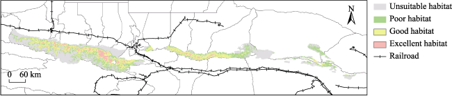
Fig. 7 Species distribution map of snow leopard habitat suitability levels in the mid-eastern Tianshan
The predicted distribution map of suitable habitats for snow leopards shows that the Tianshan Mountains have a relatively continuous distribution of high-quality habitats for snow leopards, and the moderately and highly suitable habitats for snow leopards are mainly distributed horizontally along the east-west direction of the Tianshan Mountains. In the mid-eastern Tianshan Mountains, the eastern ranges (Qitai, Jimusaer, and western Mulei) show continuous suitable habitats, while in the eastern part of Jimusaer there are only a few suitable habitats. The eastern ranges in the eastern part of the Tianshan Mountains show contiguous patches of suitable habitat, while the south-eastern part of Kumul has only a small distribution of suitable habitat.

3.4 Importance of impact factors in each patch

Considering the large east-west span of the study area, the overall habitat utilization cannot fully reflect the actual situation and is not conducive to making specific conservation recommendations. Therefore, this study further analysed the three patches in the western, central and eastern patches separately using MaxEnt software, and compared the similarities and differences of snow leopard habitat utilization among those three patches according to the Jackknife test and contribution degree results (Table 3).
Table 3 Main environmental impact factors of each patch
Patch All patches Eastern patch Central patch Western patch
Permutation
importance
(top five)
Land cover Land cover Land cover Land cover
Mean diurnal range Altitude Mean diurnal range Mean diurnal range
Isothermality Mean diurnal range Altitude Isothermality
Slope Slope Isothermality Slope
Altitude Mean temperature of driest quarter Slope Altitude
Contribution
degree results
(top five)
Land cover Land cover Land cover Land cover
Mean diurnal range Precipitation of driest quarter Mean diurnal range Mean diurnal range
Isothermality Isothermality Precipitation seasonality Mean temperature of coldest quarter
Precipitation of driest quarter Precipitation seasonality Precipitation of driest quarter Precipitation of driest quarter
Altitude Slope Isothermality Altitude

4 Discussion

4.1 Habitat selection by snow leopards in the mid-eastern Tianshan

The model predictions show that the total area of suitable habitat for snow leopards in the mid-eastern Tianshan amounts to 15919 km2, including 1836 km2 of highly suitable habitat. Overall, the suitable habitat for snow leopards in the mid-eastern Tianshan is extensive, and there is a continuous distribution of highly suitable snow leopard habitat in the east-west direction in the western part of the study area, which is located in the shallow mountainous zone of the Tianshan Mountains from north to south, in forested and high-altitude mountainous areas. The lower habitat integrity and smaller area of highly suitable habitat in the central and eastern parts of the study area may be due to the changes in the main land cover type in the central patch from west to east, from high mountainous areas to hills, plains, and forests, resulting in a decline in the suitability of snow leopard habitat.
Based on the results of a Jackknife cut and the contribution of environmental factors, land cover type, mean day temperature difference, isothermality, and elevation have the greatest influences on the distribution of snow leopards in the mid-eastern Tianshan. Land cover type is the main factor of snow leopard habitat in the mid-eastern Tianshan. As the favourite habitat type of snow leopards in the mid-eastern Tianshan, open deciduous needle-leaved forest provides concealment, ambush, and marking functions for snow leopards, so the conservation of open deciduous needle-leaved forest in protected areas is of great significance for snow leopard conservation. Mean diurnal temperature range and isothermality reflect small fluctuations in temperature. While their influences on snow leopard habitat selection have rarely been considered in past studies, some studies have shown that snow leopards are averse to areas with frequent temperature fluctuations. Altitude plays an important role in snow leopard habitat selection (Alexander et al., 2016, Watts et al., 2019), and the results of this study showed that the elevation range of suitable habitat for snow leopards in the mid-eastern Tianshan is 2500-5000 m. Compared with other suitable habitat elevations for snow leopards in China, such as the Sanjiangyuan region: 4600-4780 m (Chi et al., 2019); the Qomolangma region: around 4000 m above sea level (Bai et al., 2018); and Tashkurgan region: above 3000 m (Wang, 2012), the suitable altitude range for snow leopards in the mid-eastern Tianshan is broader. This range is partially overlapping but higher than both the 2000-2500 m predicted by Xu et al. (2006) using sample line surveys for snow leopard habitat throughout the Tianshan Mountains, and the 1700-2900 m predicted by Ma et al. (2021) for snow leopard habitat in the area from Wusu to Banfanggou in the Tianshan Mountains (Xu et al., 2006; Ma et al., 2021).
Human disturbance has been an important topic in wildlife conservation, but the results of this study showed that human footprint index and road distance did not have a large impact on snow leopard habitat selection in the mid-eastern Tianshan. However, the impact of human disturbance on snow leopard habitat use cannot be ignored (Alexander et al., 2016), and we will continue to supplement the summer survey data in order to investigate the influence of anthropogenic disturbance on snow leopard habitat selection.
Considering the above climatic, geographic and anthropogenic factors, the future temperatures on the northern slopes of the Tianshan Mountains will increase with the global warming trend (Cheng, 2018). Consequently, snow leopards in the mid-eastern Tianshan may move to higher altitudes with lower temperatures and less human disturbance in the future, consequently the total habitat area will be reduced.

4.2 Habitat selection of snow leopards in each patch

Considering the large east-west span of the study area, the impact factors at different scales may have different effects on snow leopard habitat selection. Combining the results of the independent MaxEnt analysis for each patch (Table 3), we will discuss the snow leopard habitat use in each patch in more depth.
In the western part of the western patch, which includes a large area of continuous highly suitable habitat, the difference between the habitat selection influence factor and the overall influence factor is small, and the significant difference is in factor Bio11 (Mean temperature of coldest quarter). In the response curves of the mid-eastern Tianshan as a whole, the eastern patch, and the central patch, the mean temperature of the coldest season is negatively correlated with the probability of snow leopard occurrence. The lower the temperature, the higher the probability of snow leopard occurrence, which is consistent with the impression that snow leopards are often active near the snow line. In the western patch, the response curve of the coldest seasonal mean temperature was positively correlated with the probability of snow leopard occurrence. This result may be due to the overall high altitude and low temperature of the western patch, so the minimum temperature became a factor limiting snow leopard activity. A study on snow leopard habitat selection in the forested mountainous area from Wusu to Banfanggou (i.e., the western patch of this study) in 2021 concluded that two topographic factors, ruggedness and altitude, are the main factors affecting snow leopard distribution (Ma et al., 2021). This study included more influencing factors, especially climatic factors, and found that in addition to ruggedness (slope was chosen in this study, and the correlation between slope and ruggedness was 0.975) and elevation, land cover type, mean daily temperature difference, and isothermality were also the main factors influencing snow leopard habitat selection in the forested area between Wusu and Banfanggou.
The central patch is close to several large cities in Urumqi and Changji Autonomous Prefecture, and the Miquan area is widely separated from both the western patch and the Jimusaer. Follow-up targeted surveys are needed to explore whether the snow leopard habitat in the Miquan area is disconnected from the other habitats, and to analyse the connectivity of snow leopards in the central patch. The central patch has continuous suitable habitat in Jimusaer, Qitai, and western Mulei, but there is a large area of unsuitable habitat in eastern Mulei, likely because there are many wind power facilities in the Dashitou area of eastern Mulei which leads to snow leopard exclusion.
The eastern patch is the easternmost part of the Tianshan Mountains, and the model predicts a small amount of highly suitable habitat in the southern mountains. The land cover type response results showed that grassland was the most preferred land cover type for snow leopards in the eastern patches (followed by sparse vegetation), likely due to the change in suitable land cover type in the eastern patches as a result of changes in the main predators at lower altitudes.

4.3 Conservation recommendations

This study aims to reduce the impact of anthropogenic activities on snow leopards. Based on the results of the study and discussion, three specific recommendations are made for snow leopard conservation in the Eastern Tianshan State Forestry Administration: 1) Promote the construction of protected areas; 2) Focus on protecting the habitat types favoured by snow leopards in the mid-eastern Tianshan, such as open deciduous needle-leaved forest, grassland, and sparse vegetation; and 3) Prevent habitat destruction from leading to snow leopard decline. We should further study the channels between patches in the mid-eastern Tianshan and the western Tianshan, and include the protection of snow leopard dispersal channels in the planning of roads and facilities in order to avoid further fragmentation of snow leopard habitats in the mid-eastern Tianshan due to the construction of roads. Further measures include rationalising the use of forest areas and strictly stopping illegal mining and overgrazing activities in the habitats that are suitable for snow leopards.

4.4 Shortcomings and outlook

Because the infrared cameras were deployed for less than a year, we did not use the summer snow leopard distribution data for habitat analysis. This limitation is worth noting, as some studies have shown that snow leopard habitat use differs in different seasons. Since our infrared cameras are still monitoring, further analysis of snow leopard habitat use in summer in mid-eastern Tianshan will be conducted after the current monitoring cycle to explore the differences and similarities in snow leopard habitat use in different seasons.
Only the MaxEnt model was used for habitat analysis in this analysis. To further improve the credibility of the habitat predictions, a combination of multiple habitat analysis models will be used for further analysis, and the models will be filtered by the AUC values of the analysis to reduce the possible errors generated by using a single model.
In this study, the potential habitat of snow leopards in the mid-eastern Tianshan region was mapped based on the results of a MaxEnt analysis, and the corridors and connectivity of the study area warrant further research and analysis. Corridors are linear or banded structures in the landscape that are environmentally distinct from the two adjacent sides, and are important pathways connecting patches of snow leopard habitat. Safeguarding the connectivity of snow leopard habitats within and outside the mid-eastern Tianshan and the genetic exchange of snow leopard populations are of great importance for snow leopard conservation in the study area. The corridors between the western, central, and eastern patches of the mid-eastern Tianshan should be analysed in detail, with the Miquan having a large geographical separation from the other habitats and a large number of surrounding urban roads also being the focus of corridor analysis. Whether snow leopard populations in the mid-eastern Tianshan region meet or breed with those in the western Tianshan region in the west and the Qilian Mountains in the south-east is also worth exploring.

5 Conclusions

This study is the first snow leopard survey in the whole region of the mid-eastern Tianshan, and fills a gap in snow leopard habitat suitability studies. A total of 97 and 159 survey grids were delineated by infrared camera technology in a study area of 3975 km2 in the mid-eastern Tianshan from November 2018 to June 2019 and from September 2021 to May 2022, respectively. In these two study periods, 90 and 352 infrared cameras were deployed. Twelve environmental variables were used to construct the model, and the MaxEnt model was chosen to analyse the habitat characteristics of the 194 valid snow leopard loci.
The results showed that land cover type is the most important factor for snow leopard habitat selection in the study area, and the response curves for the habitat suitability for snow leopards in the mid-eastern Tianshan showed that areas with a high probability of snow leopard occurrence are deciduous coniferous forests, grasslands, and bare rocky areas with sparse vegetation, at altitudes from 2500 m to 5000 m. Climatic factors also influence snow leopard distribution. Mean diurnal temperature range, isothermality, and precipitation of the driest quarter are the main climatic factors influencing snow leopard habitat, with mean diurnal range and isothermality making the largest contributions. The highest probability of snow leopard occurrence in the mid-eastern Tianshan was found in areas where the mean diurnal range was less than 10 ℃ and the isothermality was 30-37 ℃. The model predicted that the area of suitable habitat for snow leopards in the forest area under the jurisdiction of the mid-eastern Tianshan is about 15918.9 km2, accounting for 51.1% of the total jurisdictional area. The predicted distribution of suitable habitat for snow leopards shows that the Tianshan Mountains have a relatively continuous distribution of high-quality habitat for snow leopards, with good and excellent habitat mainly distributed horizontally along the east-west direction of the Tianshan Mountains. The habitat suitability level in the predicted area increases as the topography of the Tianshan Mountains increases in a north-south direction.
The results of this study provide basic data to support the conservation of snow leopard habitat in the mid-eastern Tianshan, and they also provide a reference for minimising the damage to snow leopard habitat through subsequent development activities such as roads and railways, and infrastructure and water conservancy projects in mid-eastern Tianshan. We plan to combine multiple models to further analyse snow leopard habitat suitability at multiple scales, improve the accuracy of the data, and provide guidance for snow leopard habitat conservation and core reserve planning. We aim to provide scientific guidance for snow leopard conservation work and the establishment of key snow leopard reserves in the Eastern Tianshan State Forestry Administration, in order to subsequently promote snow leopard population conservation in the mid-eastern Tianshan.

Acknowledgements

Thanks to the Eastern Tianshan State Forestry Administration (ETSFA) of Xinjiang Uygur Autonomous Region and its 11 branch administrative offices in Wusu, Shawan, Manasi, Hutubi, South mountain of Urumqi, Banfanggou, Miquan, Jimusaer, Qitai, Mulei, and Kumul for their funding support. Thanks to the ETSFA officers, especially Balike and Baisha, and rangers in the management stations, for their support in project coordination and the field survey. Thanks to Wang Jiahui from the School of Ecology and Nature Conservation, Beijing Forestry University, Zhong Hua from Eco-Bridge Continental, and volunteers An Siyuan and Ma Yinfei for their assistance in the field survey. Thanks to international student Leigh Ann Barran for correcting the language errors in the paper.
[1]
Alexander J S, Gopalaswamy A M, Shi K, et al. 2016. Patterns of snow leopard site use in an increasingly human-dominated landscape. Plos One, 11(5): e0155309. DOI: 10.1371/journal.pone.0155309.

[2]
Athreya V, Odden M, Linnell J D C, et al. 2013. Big cats in our backyards: persistence of large carnivores in a human dominated landscape in India. Plos One, 8(3): e57872. DOI: 10.1371/journal.pone.0057872.

[3]
Bai D F, Chen P J, Atzeni L, et al. 2018. Assessment of habitat suitability of the snow leopard (Panthera uncia) in Qomolangma National Nature Reserve based on MaxEnt modeling. Zoological Research, 39(6): 373-386.

[4]
Cheng X Y J. 2018. Study of temperature changes and applicability of reanalysis data in the Tianshan Mountains. Diss., Fuzhou, China: Fujian Normal University. (in Chinese)

[5]
Chi X W, Jiang F, Gao H M, et al. 2019. Preliminary study on habitat suitability of snow leopard (Panthera uncia) in central Tianshan Mounta. Acta Theriologica Sinica, 39(4): 397-409. (in Chinese)

[6]
Debinski D M, Holt R D. 2000. A survey and overview of habitat fragmentation experiments. Conservation Biology, 14(2): 342-355.

[7]
Fahrig L. 1997. Relative effects of habitat loss and fragmentation on population extinction. Journal of Wildlife Management, 61(3): 603-610.

[8]
Forrest J L, Wikramanayake E, Shrestha R, et al. 2012. Conservation and climate change: Assessing the vulnerability of snow leopard habitat to treeline shift in the Himalaya. Biological Conservation, 150(1): 129-135.

[9]
Harte J, Newman E A. 2014. Maximum information entropy: A foundation for ecological theory. Trends in Ecology & Evolution, 29(7): 384-389.

[10]
Huang J, Zhang Y, Wang M X, et al. 2020. Spatial and temporal distribution characteristics of drought and its relationship with meteorological factors in Xinjiang in last 17 years. Acta Ecologica Sinica, 40(3): 1077-1088. (in Chinese)

[11]
Hussain S. 2003. The status of the snow leopard in pakistan and its conflict with local farmers. Oryx, 37(1): 26-33.

[12]
Li X Y, Xiao L Y, Liang X C, et al. 2019. Threats and conservation status of snow leopards in China. Biodiversity Science, 27(9): 932-942. (in Chinese)

[13]
Ma B, Pan G L, Li L G, et al. 2021. Preliminary study on habitat suitability of snow leopard (Panthera uncia) in central Tianshan Mountain. Acta Theriologica Sinica, 41(1): 1-10. (in Chinese)

[14]
Morrison C D, Boyce M S, Nielsen S E, et al. 2014. Habitat selection of a re-colonized cougar population in response to seasonal fluctuations of human activity. The Journal of Wildlife Management, 78(8): 1394-1403.

[15]
Pearson R G, Raxworthy C J, Nakamura M, et al. 2007. Predicting species distributions from small numbers of occurrence records: A test case using cryptic geckos in Madagascar. Journal of Biogeography, 34: 102-117.

[16]
Phillips S J, Anderson R P, Schapire R E. 2006. Maximum entropy modeling of species geographic distributions. Ecological Modelling, 190(3): 231-259.

[17]
Sanderson E W, Jaiteh M, Levy M A, et al. 2002. The human footprint and the last of the wild: The human footprint is a global map of human influence on the land surface, which suggests that human beings are stewards of nature, whether we like it or not. Bioscience, 52(10): 891-904.

[18]
Seyed M-R A, Mostafa T, Hossein B. 2018. MaxEnt modeling for predicting suitable habitats and identifying the effects of climate change on a threatened species, Daphne mucronata, in central Iran. Ecological Informatics, 43: 116-123.

[19]
Syfert M M, Smith M J, Coomes D A. 2013. The effects of sampling bias and model complexity on the predictive performance of MaxEnt species distribution models. Plos One, 8(2): e55158. DOI: 10.1371/journal.pone.0055158.

[20]
Tilman D, May R M, Lehman C L, et al. 1994. Habitat destruction and the extinction debt. Nature, 371(6492): 65-66.

[21]
Wang J. 2012. Research on snow leopard (Panthera uncia) niche and population assessment in Taxkorgan, Xinjiang, China. Diss., Beijing, China: Beijing Forestry University. (in Chinese)

[22]
Watts S M, McCarthy T M, Namgail T. 2019. Modelling potential habitat for snow leopards (Panthera uncia) in Ladakh, India. Plos One, 14: e0211509. DOI: 10.1371/journal.pone.0211509.

[23]
Xiao L Y, Cheng C, Wan H W, et al. 2019. Define conservation priority areas of snow leopard habitat in Sanjiangyuan Region. Biodiversity Science, 27: 943-950. (in Chinese)

[24]
Xu F, Ma M, Wu Y Q. 2011. Population density of snow leopards (Panthera uncia) in Tomur National Nature Reserve of Xinjiang, China. Acta Theriologica Sinica, 31: 205-210. (in Chinese)

[25]
Xu F, Ma M, Yin S J, et al. 2006. Autumn habitat selection by snow leopard (Panthera uncia) in Beita Mountain, Xinjiang, China. Zoological Research, 2006(2): 221-224. (in Chinese)

[26]
Zhang X, Liu L, Chen X, et al. 2021. GLC_FCS30: Global land-cover product with fine classification system at 30 m using time-series Landsat imagery. Earth System Science Data, 13(6): 2753-2776.

Outlines

/