Evaluation and Improvement of Mine Site Quality

Evaluate the Reclamation Suitability of Dumps of Open-pit Coal Mines based on Niche Fitness in the Eastern Arid Desert Area in Northwest China

  • WEI Guangkuo , 1 ,
  • LIU Jiaqi 1 ,
  • ZHAO Tingning , 1, * ,
  • YANG Jianying 1 ,
  • LI Ruipeng 1 ,
  • KUI Guoxian 1 ,
  • AI Xianfeng 1 ,
  • XIAO Fei 2
Expand
  • 1. School of Soil and Water Conservation, Beijing Forestry University, Beijing 100083, China
  • 2. Inner Mongolia Guangna Coal Industry Co., Ltd, Wuhai, Inner Mongolia 016000, China
*ZHAO Tingning, E-mail:

WEI Guangkuo, E-mail:

Received date: 2022-11-11

  Accepted date: 2023-03-05

  Online published: 2023-07-14

Supported by

The Inner Mongolia Autonomous Region Science and Technology Major Project(2020ZD0021-03)

Abstract

Suitability evaluation of land reclamation is an important prerequisite for determining the reuse of damaged land in mining areas. To make full use of land resources in mining areas and repair damaged land, this study takes four dumps in the eastern part of the arid desert area of northwest China as the research object, and uses the platform and slope as the evaluation unit to consider ecological land as the direction. The indicators affecting the reuse of dumps are selected as five aspects: Terrain conditions, soil conditions, location conditions, irrigation and drainage facilities, and environmental risks. The suitability evaluation index system of land reclamation based on niche fitness is constructed, and the obstacle degree is introduced to diagnose the obstacle factor. The results showed that (1) the niche fitness index of each unit in the study area was between 0.339 and 0.751, indicating that the suitability grade of reclamation for ecological land is typically low. The suitability index of the same dump platform (0.511-0.751) was generally higher than that of the slope (0.339-0.628). (2) Each factor responded differently to the obstacle degree of different units. The slope, gravel content, and drainage conditions are the key elements influencing the slope. The major obstacles for the platform are soil and drainage conditions. In soil conditions, the gravel content and bulk density of the soil are limiting factors of platform. The method developed here can be effectively used to evaluate the suitability of mining areas for reclamation. The results provide a scientific basis for the reclamation and ecological reconstruction of open-pit coal mine dumps in arid desert areas of northwest China.

Cite this article

WEI Guangkuo , LIU Jiaqi , ZHAO Tingning , YANG Jianying , LI Ruipeng , KUI Guoxian , AI Xianfeng , XIAO Fei . Evaluate the Reclamation Suitability of Dumps of Open-pit Coal Mines based on Niche Fitness in the Eastern Arid Desert Area in Northwest China[J]. Journal of Resources and Ecology, 2023 , 14(4) : 805 -815 . DOI: 10.5814/j.issn.1674-764x.2023.04.013

1 Introduction

The coal industry largely ensures social and economic development, but large-scale and high-intensity coal mining brought a series of issues such as vegetation damage, landscape fragmentation, and land degradation to mines and surrounding areas (Hu and Zhao, 2021). At present, the energy sector in China is gradually shifting to the arid and semi-arid areas in the west (Wang et al., 2017; Bian et al., 2020). For example, the Shendong and Ningdong coal bases are located in northwestern arid desert areas (Zhao et al., 2018). The coal in this area is mainly thin bedrock coal seam, intensively mined (Bian et al., 2021). The waste produced by open-pit mining accumulates has led to vegetation degradation and desertification. Therefore, it is particularly necessary to facilitate the reclamation of coal mine dumps and promote the ecological restoration and environmental management of mining areas.
Land reclamation suitability evaluation is the premise and base for the reuse of damaged land in mining areas (Cheng et al., 2013). In recent years, many studies have selected the
best land use direction based on land suitability evaluation (Pilevar et al., 2020; Zhang et al., 2021), applied a variety of evaluation methods such as extreme condition method (Cui et al., 2008; Wang et al., 2012), fuzzy comprehensive evaluation method (Chen and Liu, 1999), sum of index method (Zhang et al., 2007), and analytical hierarchy processes (Sang et al., 2014). However, the above evaluation methods have limitations owing to lacking a comprehensive analysis of influencing factors, and methods such as fuzzy comprehensive evaluation are subjective.
As one of the important theories of ecology, the connotation of the niche is evolving. Grinnel (1917) defined the concept of “niche” for the firstly, emphasizing the “spatial niche”. Hutchinson (1957) put forward the concept of the “super-volume niche” based on space and resource use, which laid the foundation for modern niche theory research. Later, Wang et al. (1984) focused on the correlation and coupling of environmental characteristics and biological attributes in the niche theory; Li et al. (1993) proposed the concept of “niche fitness” by analyzing the existing niche definition, mainly measuring the suitability of species to their environment. Since then, this concept has also been widely used in the field of land suitability evaluation. For example, Yu and He (2008) evaluated land eco-economic suitability based on niche fitness and incorporated the ecological and economic needs of land into the evaluation index on the basis of considering natural conditions, which provided a novel method for land suitability evaluation. Niu et al. (2009) constructed an evaluation model of the sustainable use of cultivated land based on niche fitness, providing a basis for the formulation of regional cultivated land use plans and measures. By combining GIS with the niche fitness model, Zhao et al. (2016) provided a new approach for the quantitative analysis of the suitability of high-standard basic farmland construction. Zhao et al. (2022) established a diagnostic model of obstacle factors, coupled with the obstacle degree and the niche fitness index, based on the multi-dimensional hyper-volume niche theory, and delineated the priority areas of high-standard ecological farmland construction. Although the concept of niche fitness represents a novel idea for land evaluation, respective research is seldom applied in the field of mine land reclamation.
Therefore, it is of great theoretical and practical significance to construct a scientific and reasonable evaluation index system of land reclamation suitability and put forward an objective and feasible evaluation method for guiding mine land reclamation in arid desert areas of northwest China. In this paper, the niche fitness theory is introduced into mine land reclamation. Taking four dumps in the eastern arid desert area of northwest China as examples, the evaluation index system of ecological land reclamation direction is established, and the niche fitness evaluation method is adopted to comprehensively evaluate the suitability of the reclamation direction. Based on niche fitness, the obstacle factors are diagnosed, and those that affect land reclamation are determined, with the aim to provide a reference for making land reclamation decisions in the study area and in the surrounding mining areas.

2 Material and method

2.1 Overview of the study area

The study area is located in Hainan District, Wuhai City, Inner Mongolia Autonomous Region, with geographical coordinates of 39°28°N-39°32°N, 106°54°E-106°58°E, located at the western foot of Qianli Mountain in Ordos Plateau. The original landform is alternately distributed with low mountains and mountain depressions, with an altitude of 1269 -1312 m. The study area is an arid continental climate, average annual precipitation of 130 mm with mainly concentrated from June to September, accounting for 62% of the total annual precipitation. The surface evaporation is strong, with an average annual evaporation of 3439.70 mm. The annual average temperature is 9.0-10.3 ℃; The annual sunshine hours are 3121 hours; It is windy in spring, autumn and winter, generally northwest wind, with an average wind speed of 3.1 m s-1. The surface water resources in the mining area are extremely scarce. The area is 15 km away from the Yellow River, but the available water resources from the Yellow River are limited. The vegetation types in the study area is belong to desert vegetation, and the main plants are Halogeton glomeratus, Chenopodium, Salsola ruthenica, Achnatherum splendens, Caragana sinica, Artemisia desertorum.
There are eight coal mines in the study area, in which seven are open-pit mines and one is an underground mine. All mines are distributed in a string from north to south. Currently, there are four external dump sites in the western part of the study area (Fig. 1). The slope of the area is above 30, with a slope length from 30 m to 50 m. Prior to treatment, these dumps are slag piles without any vegetation growth. After removal of the gangue, grass seeds are sown and covered with a vegetation blanket. Irrigation is provided via drip or sprinkler irrigation. The water used in the study area mainly consists of production and domestic water, and the drainage mainly includes domestic wastewater and rainwater drainage. The pit has a guide ditch to collect rainwater or gush water, and the domestic water can be fully reused after treatment.
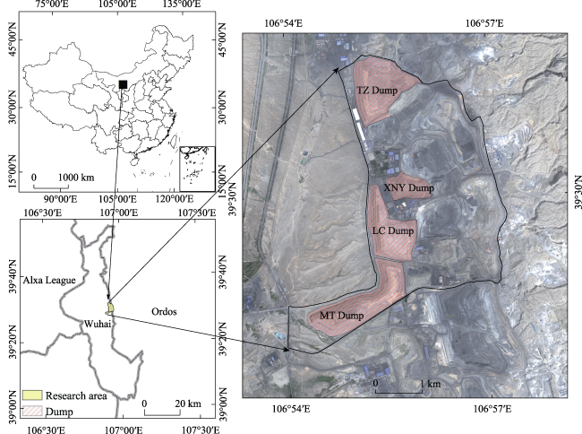
Fig. 1 Geographical location of the study area

2.2 Research methods

2.2.1 Evaluation unit division

Although the dump is a mining engineering unit, the difference in the slope leads to different unit divisions. According to the influence of slope on vegetation reconstruction and growth, the dump was divided into platform and slope (Table 1).
Table 1 Evaluation units of dumps in the study area
Evaluation unit MT platform MT slope LC platform LC slope TZ platform TZ slope XNY platform XNY slope
Area (ha) 22.98 122.01 23.74 78.63 46.75 68.88 3.2 49.11

2.2.2 Selection of land suitability evaluation index

In northwestern arid desert areas, the restoration and reconstruction of damaged ecosystems should be considered (Chen et al., 2019). As damaged land, mining areas should first and foremost be subjected to vegetation restoration. In this study, the direction of land reclamation and use is ecological land, composed of woodland and grassland with various ecological functions, and the main purpose is to restore the vegetation in mining areas.
The suitability evaluation index was determined based on five aspects: terrain conditions, soil conditions, location conditions, irrigation and drainage facilities, and environmental risks. The selection of the evaluation index was based on the principles of measurability, independence, difference, and dominance, and specific evaluation factors were determined according to the direction of ecological land reclamation. Vegetation restoration needs to fully consider the suitability of topography and soil conditions in the mining area. The elevation difference in the mining area is small, and artificial irrigation is the main irrigation type. Under the condition of artificial irrigation, the influence of slope direction on vegetation restoration is relatively small, and therefore, elevation and slope aspect were not considered, and the slope index was selected based on the terrain conditions. Regarding physical and chemical soil properties, soil bulk density, soil thickness, gravel content, and organic matter content were selected. At the social economic level, it is necessary to consider convenience. For the mining area, the main influence index of the location condition is the distance from the road. The closer the distance, the easier the subsequent mechanical construction. The surrounding land type represents the land type around the dump. If it is consistent with the direction of land reclamation, the suitability is higher. Regarding plant growth, it is necessary to meet irrigation and drainage requirements. In arid desert mining areas, due to less precipitation, irrigation and drainage must be optimized. In terms of environmental risks, coal mining has serious impacts on vegetation restoration; it not only damages the land but also causes heavy metal pollution in the soil and geological issues caused by the long-term stacking of coal gangue. In this sense, the degree of heavy metal pollution and the geological disaster susceptibility should be considered.

2.2.3 Data acquisition and processing

The data acquisition methods of this study were field investigation, data collection, and software analysis:
(1) Topographic data: UAV were used to collect DEM data of four dumps with a 4 m accuracy. Global mapper was used to measure the slope gradient of each level.
(2) Soil data: Soil bulk density was measured via the cutting ring method, and the gravel content was determined using the screening method, calculating the weight of gravel > 2 mm. The organic matter level was measured by the potassium dichromate volumetric method. Heavy metals in soil were extracted by aqua regia and inductively coupled plasma mass spectrometry (ICP-MS), and the contents of cadmium, chromium, lead, and arsenic were determined. Taking the undisturbed background values around the study area as the standard, and referring to Guo et al. (2011), soil heavy metal pollution was calculated by Nemero comprehensive pollution index method.
(3) Irrigation and drainage facilities: Irrigation and drainage conditions were determined by on-site investigation.
(4) Location conditions: The shortest distance from the road was calculated by Euclidean distance in ArcGIS; the surrounding land types were determined by on-site investigation.
(5) Susceptibility to geological disasters was determined according to the soil and water conservation plan of the mining area and investigation.

2.2.4 Determination of the optimum value of niche fitness

According to the concept of niche fitness, each factor has an optimal niche (Ouyang et al., 1996). The optimum value of soil bulk density was determined by referring to a relevant study (Zhang et al., 2014). Slope, soil layer thickness, and soil organic matter content were divided according to the standard of arid desert and semi-desert areas in the general rules for classification and grading of natural resources. Irrigation conditions, drainage conditions, surrounding land types, geological disaster susceptibility, and other indicators are defined by discrete data and needed to be quantified referring to the general rules for classification and grading of natural resources and related research (Zhang et al., 2014; Yang, 2020), with the score of 100 as the optimum value. The optimum value of road distance from the mining area was determined according to on-site investigation and related research (Du, 2019; Yang, 2020). The results are shown in Tables 2 and 3.
Table 2 Classification and assignment of discrete indicators
Index Grade scale Score
Irrigation condition Satisfying irrigation 100
Basic satisfaction 80
Irrigation difficulties 50
No irrigation facilities 0
Drainage condition Guaranteed 100
Unstable 80
Drainage difficulties 40
No drainage facilities 10
Peripheral land type Farmland 100
Grassland 70
Construction land 50
Bare ground 10
Heavy metal pollution degree Pollution-free 100
Slight pollution 70
Moderate pollution 40
Severe pollution 10
Geological disaster susceptibility Unlikely 100
More likely to occur 60
Easy to occur 30
Table 3 Evaluation index system of ecological land suitability
Criterium layer Index layer Optimum value Minimum value Maximum value Type
Terrain condition Slope (°) 2 2 25 Negative direction
Soil condition Soil bulk density (g cm-3) 1.25 1.25 1.70 Negative direction
Gravel content (%) 0 0 10 Negative direction
Organic matter content (mg kg-1) 20 5 20 Positive direction
Soil layer thickness (cm) 100 10 100 Positive direction
Location condition Peripheral land type 100 10 100 Positive direction
Road distance (m) 200 200 700 Negative direction
Irrigation and drainage facilities Irrigation condition 100 0 100 Positive direction
Drainage condition 100 10 100 Positive direction
Environmental risks Heavy metal pollution degree 100 10 100 Positive direction
Geological disaster susceptibility 100 30 100 Positive direction

2.3 Niche fitness calculation

2.3.1 Calculation of the single-factor niche fitness index

In land reclamation, niche fitness indicates the suitability of each evaluation unit for each evaluation factor in a specific reclamation direction, which is measured by the ecological suitability index (Du, 2019). When the evaluation unit does not meet the conditions of the reclamation direction at all, the niche fitness of the evaluation unit is 0. When the evaluation unit fully meets the conditions of the reclamation direction, the niche fitness of the evaluation unit is 1; the niche fitness value range is therefore [0,1] (Ding et al., 2010).
As far as the positive impact factor is concerned, for a specific reclamation direction, it must meet the minimum requirements, and the higher the value, such as soil layer thickness, the better niche fitness. The formula is as follows:
$\text{ }\!\!~\!\!\text{ }{{N}_{i}}=\left\{ \begin{matrix} 0\ \ \ \ \ \ \ \ \ \ \ \ \ \ {{X}_{i}}<{{D}_{i\text{min}}} \\ \frac{{{X}_{i}}}{{{D}_{i\text{opt}}}}\ \ \ \ ~{{D}_{i\min }}\le {{X}_{i}}<{{D}_{i\text{opt}}} \\ 1\ \ \ \ \ \ \ \ \ \ \ \ \ \ {{X}_{i}}\ge {{D}_{i\text{opt}}} \\ \end{matrix} \right.$
where Ni is the niche fitness index of the single factor, Xi is the actual niche of the index, Dimin is the minimum niche value of the index, and Diopt is the optimum niche value of the index.
Regarding the negative impact factors, for a specific reclamation direction, the lower the current value, such as for slope and gravel content, the better. The formula is as follows:
$\text{ }\!\!~\!\!\text{ }{{N}_{i}}=\left\{ \begin{matrix} 1\ \ \ \ \ \ \ \ \ \ \ \ \ \ \ \ \ \ \ \ \ \ \ \ {{X}_{i}}<{{D}_{i\text{min}}} \\ \frac{{{D}_{i\text{max}}}-{{X}_{i}}}{{{D}_{i\text{max}}}-{{D}_{i\text{opt}}}}~\ \ \ \ {{D}_{i\text{min}}}\le {{X}_{i}}<{{D}_{i\text{max}}} \\ 0\ \ \ \ \ \ \ \ \ \ \ \ \ \ \ \ \ \ \ \ \ \ \ {{X}_{i}}\ge {{D}_{i\text{max}}} \\ \end{matrix} \right.$
where Dimax is the maximum niche value of the index.

2.3.2 Calculation of the comprehensive niche fitness index

Individual indicators can only reflect the suitability from one aspect, whereas the comprehensive index method can integrate scattered individual information (Zhang and Liu, 2013). According to the comprehensive index method, the calculation formula of weighted comprehensive niche fitness is as follows:
$NF=\underset{i=1}{\overset{n}{\mathop \sum }}\,{{N}_{i}}\times {{W}_{j}}$
where NF is the comprehensive ecological suitability index, and Wj represents the weight of the index.

2.3.3 Weight determination

The entropy method, as an objective weighting method, determines the weight according to the correlation of each index or the variation degree of each index value. The use of this method can reduce the influence of subjective factors (Li et al., 2011).
The range method is used to process index’s original data. The positive index processing formula is shown in (4), and the negative index processing formula is shown in (5). Determine the entropy and entropy weight after transforming the data into a matrix.
${{y}_{ij}}=\frac{{{X}_{ij}}-\text{min}({{X}_{ij}})}{\max ({{X}_{ij}})-\text{min}({{X}_{ij}})}$
${{y}_{ij}}=\frac{\max ({{X}_{ij}})-{{X}_{ij}}}{\max ({{X}_{ij}})-\text{min}({{X}_{ij}})}$
${{Z}_{ij}}={{y}_{ij}}/\underset{i=1}{\overset{n}{\mathop \sum }}\,{{y}_{ij}}$
${{b}_{j}}=-\left( \underset{i=1}{\overset{n}{\mathop \sum }}\,{{Z}_{ij}}\ln {{Z}_{ij}} \right)/\text{ln}n$
${{W}_{j}}=(1-{{b}_{j}})/\underset{j=1}{\overset{m}{\mathop \sum }}\,(1-{{b}_{j}})$
where yij is the data processed by the range method, Xij is the actual value of the index, min(Xij) is the measured minimum value of the index, max(Xij) is the maximum value of the index, Zij is a standardized matrix, bi is the entropy value of the evaluation index, and Wj is entropy weight. i=1, 2, 3,…, n; j=1, 2, 3…, m; 0≤bi≤1; 0≤Wj≤1; W1+W2+W3+…+Wm=1.

2.4 Obstacle factor diagnosis based on niche fitness

The obstacle degree model can fully excavate the obstacle factors that affect the development of factors (Chen et al., 2020; Xu et al., 2021) By learning from correlation (Li and Nan, 2015; Lei et al., 2016), three variables were introduced, namely the obstacle degree, the index deviation degree, and the factor contribution degree, to diagnose obstacle factors, and the obstacle degree and its obstacle factors that affect land reclamation were obtained. The factor diagnosis model is as followings:
${{C}_{i}}=\frac{{{I}_{i}}\times {{W}_{j}}}{\sum\limits_{i=1}^{n}{({{I}_{i}}\times {{W}_{j}})}}$
${{I}_{i}}=1-{{N}_{i}}$
The index deviation ${{I}_{i}}$ represents the difference between the actual value of each index and the optimal value of the index, ${{C}_{i}}$ is the obstacle degree of the index, Wj is the index weight, and ${{N}_{i}}$ is the niche fitness value of the single index.

3 Results and analysis

3.1 Niche fitness index of single factor and the weight calculation

According to Formulas (1) to (2), the single-factor niche fitness index of each evaluation unit was calculated as showing in Fig. 2. The niche fitness index of single factor was within the range [0,1]. From the perspective of terrain, because the slope between platforms and slopes were different, the average slope of dump platforms were below 2°, and their niche fitness values were 1. The slopes of dump slope generally exceeded the threshold of 25°, and the niche fitness of slope was 0. The ecological suitability index of the soil layer thickness, bulk density, and gravel content of each evaluation unit was low, with the niche fitness of the soil layer thickness ranging from 0.16 to 0.42, bulk density ranging from 0 to 0.51, and gravel content ranging from 0 to 0.71.
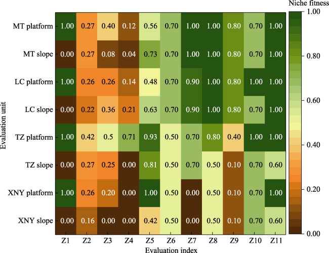
Fig. 2 Single-factor niche fitness index diagram

Note: Z1 to Z11 represent slope, soil thickness, bulk density, gravel content, organic matter content, surrounding land types, road distance, irrigation conditions, drainage conditions, heavy metal pollution degree and geological disaster susceptibility, respectively.

Except for TZ platform (0.93), XNY platform (1.00), and TZ slope (0.81), the suitability of the organic matter content in the other units was at a medium level. In terms of location conditions, TZ and XNY dumps showed a lower suitability for surrounding land types and distance from mining roads than MT and LC dumps. Regarding the irrigation and drainage facilities, the niche fitness index values of TZ slope, XNY platform, and XNY slope were also low because of difficulties in irrigation and drainage. From the aspect of environmental risks, TZ platform and LC platform had low heavy metal pollution degrees and a suitability index of 1, whereas the other units had a value of 0.7. The suitability index of geological hazard susceptibility of TZ slope and XNY slope was 0.7, and that of the other units was 1.
The original data matrix was established according to the constructed evaluation index system, and the weight of each index was calculated by the entropy method. The weight of each index is shown in Table 4.
Table 4 Weight of the reclamation suitability evaluation indices of the dump sites
Index Z1 Z2 Z3 Z4 Z5 Z6 Z7 Z8 Z9 Z10 Z11
Entropy value 0.71 0.77 0.78 0.76 0.73 0.58 0.74 0.66 0.66 0.29 0.75
Weight 0.08 0.06 0.06 0.07 0.08 0.12 0.07 0.09 0.10 0.20 0.07

3.2 Suitability grading

Considering the value of the comprehensive niche fitness index, the comprehensive niche fitness index was divided into four grades: highly suitable, moderately suitable, barely suitable, and unsuitable. As indicated in a previous study, a suitability index value N=0.5 corresponds to the lower limit of the suitability interval of the index (Elaalem et al., 2011). Therefore, 0.5 was taken as the suitability threshold in this study. If the suitability index N≤0.5, the area is unsuitable, and if N>0.5, it is suitable. Within the suitable area, subareas were classified as highly suitable (N>0.85), moderately suitable (0.75<N≤0.85), and barely suitable (0.5<N≤0.75). The suitability classification is shown in Table 5.
Table 5 Suitability grading of the different areas
Grade Suitability index Implications
Highly suitable >0.85 Land use conditions are highly in line with the reclamation direction
Moderately suitable 0.75-0.85 The land use conditions in the reclamation direction can be achieved with a little improvement.
Barely suitable 0.5-0.75 Comprehensive renovation can achieve the land use conditions in the direction of reclamation.
Unsuitable ≤0.5 Difficulties in ecological restoration and reconstruction
According to Formula (3), the comprehensive niche fitness index was calculated. As seen in Table 6, the niche fitness index of each unit in the study area was between 0.339 and 0.751, and generally, the suitability of the land for reclamation was low. Not all evaluation units reached the highest suitability level, and the comprehensive niche fitness index of TZ platform was 0.751, indicating moderately suitable. The MT platform (0.709), MT slope (0.616), LC platform (0.747), LC slope (0.628), and XNY platform (0.511) were barely suitable, whereas TZ slope (0.443) and XNY slope (0.339) were unsuitable. Generally, affected by the slope, the suitability index of the same dump platform (0.511-0.751) for ecological land reclamation was higher than that of the slope (0.339-0.628). Platform TZ (0.751) was covered with thick soil, with a low gravel content; although the soil condition was superior, it was moderately suitable, whereas the other platforms were barely suitable. However, the niche fitness index of TZ platform was close to the lower limit of moderately suitable (0.75, 0.85], and the suitability level of XNY platform was close to the lower limit of barely suitable (0.51, 0.75], which indicates that the suitability level of this platform was unstable and at risks of declining.
Table 6 Comprehensive niche fitness index values of the different evaluation units
Evaluation unit MT platform MT slope LC platform LC slope TZ platform TZ slope XNY platform XNY slope
Suitability index 0.709 0.616 0.747 0.628 0.751 0.443 0.511 0.339
Appropriate grade Barely suitable Barely suitable Barely suitable Barely suitable Moderately suitable Unsuitable Barely suitable Unsuitable
Drought-resistant and barren-resistant shrubs and herbs are primarily selected in conjunction with the investigation of coal mine dump vegetation in the arid desert area of northwest China. Artemisia desertorum, Astragalus laxmannii, Medicago sativa, Caragana korshinskii, Halogeton glomeratus, Grubovia dasyphylla, and others are suitable plants; shrubs can be transplanted with container seedlings, and herbs can be mixed with grass seeds. However, the dump slope is restricted by its inherent conditions, which makes ecological reconstruction more difficult. The TZ slope and XNY slope are not suitable for reclamation as ecological land, indicating that the dump slope needs to be comprehensively renovated first. The restoration of vegetation should be carried out progressively on the basis of slope stability.

3.3 Obstacle factor diagnosis based on niche fitness

According to the suitability evaluation results, except for TZ platform, which had a moderately suitability level, the other units were barely suitable or unsuitable, indicating that comprehensive remediation measures are required to transform or even eliminate the obstacle factors. First, it is necessary to diagnose the obstacle factors that affect the reclamation of the dumps. According to Formulas (9) to (10), we calculated the obstacle degree of each unit and selected the first three indices with the largest obstacle degrees as the main obstacle factors (Table 7). As seen in Figure 3, each index responded differently to the obstacle degrees of different evaluation units.
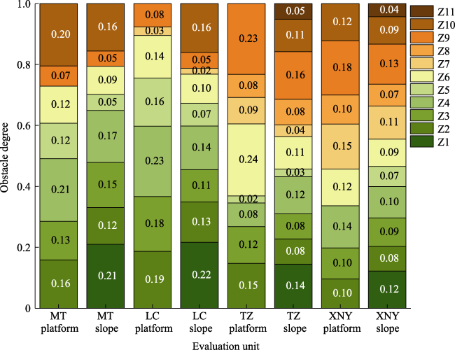
Fig. 3 Obstacle degree diagram of the evaluation units
Table 7 Obstacle degrees of the main obstacle factors in each dump unit
Evaluation unit Factor ranking Cumulative
obstacle degree
1 2 3
MT platform C4 (0.21) C10 (0.20) C2 (0.16) 0.57
LC platform C4 (0.23) C2 (0.19) C3 (0.18) 0.60
TZ platform C6 (0.24) C9 (0.19) C2 (0.15) 0.62
XNY platform C9 (0.18) C7 (0.15) C4 (0.14) 0.46
MT slope C1 (0.21) C4 (0.17) C10 (0.16) 0.54
LC slope C1 (0.22) C10 (0.16) C4 (0.14) 0.52
TZ slope C9 (0.16) C1 (0.14) C4 (0.12) 0.42
XNY slope C9 (0.13) C1 (0.12) C4 (0.11) 0.36
Terrain obstacle degree (${{C}_{1}}$): The terrain obstacle degree of MT platform, LC platform, TZ platform, and XNY platform was 0, and the reclamation of the above units was therefore unaffected by the slope. The four evaluation units of MT slope, LC slope, TZ slope, and XNY slope were affected by the terrain, and the terrain obstacle degree was between 0.12 and 0.22, making the slope the main obstacle factor affecting reclamation.
Soil conditional obstacle degree (${{C}_{2}}-{{C}_{5}}$): The soil conditional obstacle degree ranged between 0.31 and 0.76, accounting for a large proportion in each unit. The soil conditional obstacle degrees of the MT and LC platforms reached 0.61 and 0.76, respectively, and the gravel content was the primary obstacle factor affecting the reclamation of these platforms. The soil barrier degrees of MT slope and LC slope were 0.49 and 0.46, and soil thickness, soil bulk density, and gravel content were the main obstacle factors of these units. The soil conditional obstacle degrees of other units ranged between 0.31 and 0.37, and the soil condition was an important factor limiting reclamation.
Location conditional obstacle degree (${{C}_{6}}-{{C}_{7}}$): The location conditional obstacle degree ranged between 0.11 and 0.32. Both TZ dump and XNY dump were located inside the mining area, and the surrounding land was mainly used for mining and therefore greatly affected by mining activities; because of the complex road system of these dumps, the locations restrictions were severe. Both MT dump and LC dump were mainly surrounded by natural vegetation; the dumps were in close proximity to the coal line and convenient to enter and exit, resulting in a low obstacle degree of location.
Obstacle degree of irrigation and drainage facilities (${{C}_{8}}-{{C}_{9}}$): The obstacle degree of irrigation and drainage facilities ranged between 0.07 and 0.31. Irrigation and drainage facilities were also the main obstacles affecting the reclamation of TZ dump and XNY dump, with values of 0.31 and 0.24 for TZ platform and TZ slope, respectively, and 0.27 and 0.20 for XNY platform and XNY slope, respectively. The irrigation and drainage facilities of the above two dumps had been established three years ago, and the micro-spray irrigation system showed signs of aging. In addition, the ecological bag stacked drainage ditch cannot effectively drain water in case of sudden heavy rainfall, and slope erosion can damage irrigation and drainage facilities. The MT and LC dumps were mainly equipped with sprinkler and drip irrigation facilities, which were well maintained. The irrigation conditions in the later period were fully met, and the masonry drainage ditch on the slope could effectively intercept and drain water. Therefore, the obstacles of irrigation and drainage facilities in MT and LC dumps were negligible.
Environmental risks obstacle degree (${{C}_{10}}-{{C}_{11}}$): the environmental risks obstacle degree ranged between 0 and 0.20. Except for LC platform and TZ platform, all units had environmental risks. Both TZ slope and XNY slope showed risks of light heavy metal pollution, and some slopes of TZ and XNY dumping sites exceeded 40 degrees, potentially causing collapses and landslides. The environmental risks of LC slope, MT platform, and MT slope were mainly heavy metal pollution, albeit with a slight pollution. The obstacle degrees of heavy metal pollution were 0.20, 0.16, and 0.16, respectively, in the above units.

4 Discussion

4.1 Analysis of reclamation suitability based on niche fitness

The study area was located in the arid desert area of northwest China, and because of its special geographical environment and climatic conditions, surface water resources are extremely scarce and limited to seasonal surface runoff. According to the “Detailed Plan for Total Control Index of Yellow River Water Intake Permit in Inner Mongolia”, Wuhai City allocates about 50 million cubic meters of Yellow River water yearly, but the actual available Yellow River water resources in the mining area are extremely limited. West-northwest wind prevails in the study area, and wind-blown sand disasters are frequent (Wu, 2020). Therefore, the coal mine dump of study area is mainly suitable for ecological restoration, and the development direction is ecological land. Water is an important condition for plant survival. Severe evaporation and excessive solar radiation in arid regions of northwest China seriously affect normal plant growth (Zhang, 2021). In this paper, the irrigation conditions were quantitatively treated when the evaluation indices were selected, and the source of irrigation water should be considered on the basis of whether there are irrigation facilities or not. Based on on-site investigation, there are water-collecting facilities in coal mines, and mine water and precipitation are collected through water guide ditches, which can then be used for irrigation water, and the domestic water in the mining area passes through.
There are some problems in this study. The terrain conditions in the study area are complex, the vegetation coverage is low, and the strong winds are likely to cause wind-blown sand disasters. The ecological restoration of the dumps will also be affected by the local wind-blown sand movement. This makes it necessary to analyze the air flow on the surface, with the aim to provide a basis for wind proofing and sand control in the dump. In addition to the evaluation indices involved in this paper, land reclamation in mining areas is also affected by various natural, social, and economic conditions such as climate, population, and policies, among others. Because of the limited access to data, the evaluation index system needs to be further improved in the future.
In this paper, the niche fitness theory and the content of mine land reclamation are combined to evaluate the suitability of mine dump reclamation, and the original niche fitness model is improved. Based on the entropy weight method, the comprehensive index method is used to calculate the comprehensive niche fitness index, and the obstacle degree model is introduced to determine and diagnose the obstacles that affect the reclamation of each unit. This method focuses on the micro-level, establishes an index evaluation system for the dump, and evaluates the dump evaluation unit from the “positive” and “negative” angles of suitability and obstacle degree, deepening the connotation of the suitability of land reclamation in mining areas. At the same time, this method reduces the influence of subjective factors, can objectively reflect the present situation of mining areas, and provides a reference for land reclamation decision-making in mining areas.

4.2 Analysis on the difficulty of obstacle factor transformation based on niche fitness

According to the results of the suitability evaluation, the suitability level of the reclamation of dumps for ecological land is generally low, and comprehensive remediation measures are needed to transform or even eliminate the obstacle factors. Because of the different obstacle factors of each unit, remediation is necessary according to the degree of difficulty and following the order from easy to difficult, with the aim to obtain the best remediation benefits. In theory, the slope can be adjusted to the steps of the dump by cutting. However, when adjusting the slope angle, the height, and the width of the steps, it is necessary to maintain the stability and consider the impact on the surrounding ecological environment. In addition, because of the high costs and long duration, it is difficult to reform the slope (Zhao et al., 2016; Liu, 2020). Wang et al. (2011) reported that the soil layer thickness and soil bulk density can be greatly improved after taking deep ploughing and subsoiling measures, making the transformation less difficult. However, gravel occurs widely in the soil, which is affected by the types and positions of gravel in the soil, and the degree and process of the impact on the soil are complex (Gargiulo et al., 2016; Hu et al., 2021). The organic matter content can greatly be improved by adding organic fertilizer, facilitating the transformation (Song et al., 2017). As spatial factors, the surrounding land type and the distance from the road in the mining area involve many social and economic factors, and transformation solely based on engineering measures is difficult (Zhao et al., 2022). Irrigation and drainage facilities are relatively easy to transform, making it necessary to consider the problem of irrigation water source on the basis of a rational layout of micro-spray and drip irrigation in the dump. Heavy metal pollution, as an environmental risks factor, can be comprehensively treated by biological or engineering measures, although this requires a long investment period (Zhao, 2018). Based on the results of the field investigation, the occurrence of geological disasters in the dump is not only related to the slope, but some dump slopes are also seriously eroded due to the lack or damage of intercepting and drainage facilities. This increases the risk of landslides or collapses, impeding reconstruction. According to the above analysis, the difficulty degree of the obstacle factor transformation was divided into difficult and easy (Table 8).
Table 8 Difficulty grades of obstacle factor transformation
Degree of transformation Obstacle factor
Difficult Slope, gravel content, surrounding land types, road distance, heavy metal pollution degree, geological disaster susceptibility
Easy Soil bulk density, soil thickness, organic matter content, irrigation conditions, and drainage conditions
Overall, the soil, irrigation, and drainage facilities are the factors that can easily be transformed in dump reclamation. Based on the soil cover, fertilization, and rotary tillage, on the platform, sticks or bags can be arranged in squares, and grass seeds can be sown to increase resistance; the grass can further be covered with non-woven fabrics to resist ultraviolet rays and irrigated by micro-spraying or drip irrigation facilities. The high and steep slope of the dump can be cut, and ecological restoration technologies, such as water interception plate planting and the establishment of a Salix psammophila sand barrier, can be applied. Vegetation restoration is carried out by mixed sowing and multi-tree planting. The factors that are difficult to transform will be treated according to the actual situation of the mining area.

5 Conclusions

(1) Based on niche fitness to evaluate suitability of land reclamation is an important method, the niche fitness index of each unit in the study area was between 0.339 and 0.751, indicating that the suitability grade of reclamation for ecological land is typically low. The platform is mostly barely suitable, with the exception of MT slope and LC slope, while other slope units are unsuitable. In the same dump, the platform slope is short, the soil quality is good, and the niche fitness index (0.511-0.751) is often higher than the slope (0.339-0.628).
(2) Each factor responded differently to the obstacle degree of different units. The slope, gravel content, and drainage conditions are the key elements influencing the slope. The major obstacles for the platform are soil and drainage conditions. In soil conditions, the gravel content and bulk density of the soil are limiting factors of platform.
[1]
Bian Z F, Yu H C, Hou J, et al. 2020. Influencing factors and evaluation of land degradation of 12 coal mine areas in Western China. Journal of China Coal Society, 45(1): 338-350. (in Chinese)

[2]
Bian Z F, Yu H C, Lei S G, et al. 2021. Strategic consideration of exploitation on coal resources and its ecological restoration in the Yellow River Basin, China. Journal of China Coal Society, 46(5): 1378-1391. (in Chinese)

[3]
Chen J F, Liu W M. 1999. An integrated evaluation of land suitability based on fuzzy set theory. Resources Science, 21(4): 71-74. (in Chinese)

[4]
Chen Y, Zhu M K, Lu J L, et al. 2020. Evaluation of ecological city and analysis of obstacle factors under the background of high-quality development: Taking cities in the Yellow River Basin as examples. Ecological Indicators, 118(1): 106771. DOI: 10.1016/j.ecolind.2020.106771.

DOI

[5]
Chen Y N, Chen Y P, Zhu C G, et al. 2019. The concept and mode of ecosystem sustainable management in arid desert areas in northwest China. Acta Ecologica Sinica, 39(20): 7410-7417. (in Chinese)

[6]
Cheng L L, Lou S, Liu L F, et al. 2013. Technology system and method of spatial structure optimization for mining wasteland reuse. Transactions of the Chinese Society of Agricultural Engineering, 29(7): 207-218, 297. (in Chinese)

[7]
Cui Y, Bai Z K, Zhang J D, et al. 2008. Methods and application of agricultural land suitability evaluation in open-cast mining area. Transactions of the Chinese Society of Agricultural Engineering, 24(S1): 181-184. (in Chinese)

[8]
Ding N, Jin X B, Tang X C, et al. 2010. An application of the variable weight method based on ecological niche-fitness to reclamation suitability evaluation for land temporarily used for high-speed railway construction: A case study in Beijing-Shanghai high-speed railway Changzhou section. Resource Science, 32(12): 2349-2355. (in Chinese)

[9]
Du J P. 2019. Study on the direction of reclamation and utilization of temporary construction land in Chongqing Coal Mine: A case study in Qijiang. Diss., Chongqing, China: Chongqing Normal University. (in Chinese)

[10]
Elaalem M, Comber A, Fisher P. 2011. A comparison of fuzzy AHP and ideal point methods for evaluating land suitability. Transactions in GIS, 15(3): 329-346.

DOI

[11]
Gargiulo L, Mele G, Terribile F. 2016. Effect of rock fragments on soil porosity: A laboratory experiment with two physically degraded soils. European Journal of Soil Science, 67(5): 597-604.

DOI

[12]
Grinnell J. 1917. The niche-relationships of the California thrasher. The Auk, 34(4): 427-433.

DOI

[13]
Guo W, Zhao R X, Zhang J, et al. 2011. Distribution characteristic and assessment of soil heavy metal pollution in the iron mining of Baotou in Inner Mongolia. Environmental Science, 32(10): 3099-3105. (in Chinese)

DOI

[14]
Hu H, Bao W K, Zhang Q, et al. 2021 Effect of rock fragment content on roots and plant growth: A review. Chinese Journal of Applied and Environmental Biology, 27(2): 303-308. (in Chinese)

[15]
Hu Z Q, Zhao Y L. 2021. Main problems in ecological restoration of mines and their solutions. China Coal, 47(9): 2-7. (in Chinese)

[16]
Hutchinson G E. 1957. Concluding remarks. Cold Spring Harbor Symposia on Quantitative Biology, 22: 415-427.

DOI

[17]
Lei X P, Qiu R, Liu Y. 2016. Evaluation of regional land use performance based on entropy TOPSIS model and diagnosis of its obstacle factors. Transactions of the Chinese Society of Agricultural Engineering, 32(13): 243-253. (in Chinese)

[18]
Li C Y, Nan L. 2015. Dynamic evaluation and diagnosis of obstacle factors on land eco-security in Shaanxi Province. China Land Sciences, 29(4): 72-81. (in Chinese)

[19]
Li X X, Wang K S, Liu L W, et al. 2011. Application of the entropy weight and TOPSIS method in safety evaluation of coal mines. Procedia Engineering, 26: 2085-2091.

DOI

[20]
Li Z Z, Zhao S L, Zhang P Y. 1993. The niche-fitness theory and its application to the systems of crop growth. Journal of Lanzhou University, 29(4): 219-224. (in Chinese)

[21]
Liu H L. 2020. Research on the theory and practice of the restoration and utilization model for the mine environment. Diss., Beijing, China: China University of Mining & Technology. (in Chinese)

[22]
Niu H P, Zhao T Q, Zhang A L, et al. 2009. Cultivated land sustainable use evaluation based on niche-fitness. Acta Ecologica Sinica, 29(10): 5535-5543. (in Chinese)

[23]
Ouyang Z Y, Wang R S, Fu G N. 1996. Ecological niche suitability model and its application in land suitability assessment. Acta Ecologica Sinica, 16(2): 449-456. (in Chinese)

[24]
Pilevar A R, Matinfar H R, Sohrabi A, et al. 2020. Integrated fuzzy, AHP and GIS techniques for land suitability assessment in semi-arid regions for wheat and maize farming. Ecological Indicators, 110: 105887. DOI: 10.1016/j.ecolind.2019.105887.

DOI

[25]
Sang Y K, Zhao D D, Jiang J L, et al. 2014. Evaluation of agricultural science park planning based on suitability of function land. Transactions of the Chinese Society of Agricultural Engineering, 30(10): 217-224. (in Chinese)

[26]
Song A A, Wang H M, Zheng Y D, et al. 2017. Suitability evaluation of arable land consolidation and diagnosis of obstacle indicators in Taihang mountainous area—A case study in Laiyuan County of Hebei. Chinese Journal of Agricultural Resources and Regional Planning, 38(10): 45-53. (in Chinese)

[27]
Wang A L, Zhao G X, Wang Q F, et al. 2011. Effects of land consolidation on soil physical and chemical characteristics of hilly region. Transactions of the Chinese Society of Agricultural Engineering, 27(9): 311-315. (in Chinese)

[28]
Wang G, Zhao S L, Zhang P Y, et al. 1984. On the definition of niche and the improved formula for measuring niche overlap. Acta Ecologica Sinica, 4(2): 119-127. (in Chinese)

[29]
Wang L, Lei S G, Bian Z F. 2017. Review on study of ecological damage and natural recovery in the coal mining subsidence area in Western China. Resource Development & Market, 33(10): 1188-1192. (in Chinese)

[30]
Wang S D, Guo Z, Chen Q J, et al. 2012. Study and application of suitability evaluation of land reclamation based on comprehensive extreme condition method. Science of Surveying and Mapping, 37(1): 67-70, 66. (in Chinese)

[31]
Wu H X. 2020. Study on characteristics and source apportionment of dustfall pollution in coal mine area of Northwest China—A case study of Wuhai Open-pit Mining Area. Diss., Beijing, China: Beijing Forestry University. (in Chinese)

[32]
Xu S K, Zuo Y F, Zhang M. 2021. Evaluation of tourism ecological security and diagnosis of obstacle factors in China based on fuzzy object element model. Scientia Geographica Sinica, 41(1): 33-43. (in Chinese)

DOI

[33]
Yang H. 2020. Study on land reclamation of Daliu coal mine in Xuzhou. Diss., Jinan, China: Shandong Normal University. (in Chinese)

[34]
Yu Y, He J H. 2008. Land eco-economical suitability evaluation based on niche fitness. Transactions of the Chinese Society of Agricultural Engineering, 24(1): 124-128. (in Chinese)

[35]
Zhang C X, Xu L, Zhou X C. 2007. Land suitability assessment of vegetation restoration of the coal gangue pile of Fuxin mine area. Research of Soil and Water Conservation, 14(3): 246-248. (in Chinese)

[36]
Zhang J J. 2021. Effect evaluation of slope repair mode in open-pit coal mine dump. Diss., Beijing, China: Beijing Forestry University. (in Chinese)

[37]
Zhang L, Bai Z K, Jing M, et al. 2014. Type classification for vegetation restoration on dump of large opencast coal-mine in loess area—Taking Antaibao Opencast Coal-Mine as an example. Research of Soil and Water Conservation, 21(6): 54-60. (in Chinese)

[38]
Zhang R, Liu Y Z. 2013. Evaluation on cultivated land ecological security based on the PSR model and diagnosis of its obstacle indicators in China. Resources and Environment in the Yangtze Basin, 22(7): 945-951. (in Chinese)

[39]
Zhang Y Z, Xiong J H, Ye J P. 2021. Suitability evaluation of mining-land reuse from the perspective of stakeholders. Geography and Geo-Information Science, 37(1): 89-97. (in Chinese)

[40]
Zhao S X. 2018. Evaluation of spatial suitability, stability and its spatio-temporal distribution of well-facilitated farmland construction. Diss., Jiaozuo, China: Henan Polytechnic University. (in Chinese)

[41]
Zhao S X, Niu H P, Zhang W W, et al. 2016. Suitability evaluation on high quality capital farmland consolidation based on niche-fitness model. Transactions of the Chinese Society of Agricultural Engineering, 32(12): 220-228. (in Chinese)

[42]
Zhao T N, Zhang Y X, Cao B, et al. 2018. Eco-security technology for coal mining bases in the northwestern arid desert regions in China. Journal of Soil and Water Conservation, 32(1): 1-5. (in Chinese)

[43]
Zhao Z T, Kong X B, Zhang X L, et al. 2022. Method for zoning high-standard ecological farmland construction using multi-dimensional super-volume ecological niche. Transactions of the Chinese Society of Agricultural Engineering, 38(13): 253-263. (in Chinese)

Outlines

/