Evaluation and Improvement of Mine Site Quality

Site Type Division and Evaluation of the Waste Dump in an Arid Open-pit Mining Area—Taking the Treated Waste Dump in Wuhai City as an Example

  • WAN Yajun ,
  • GUO Xiaoping , * ,
  • LI Qingfeng ,
  • XUE Xinyue
Expand
  • School of Soil and Water Conservation, Beijing Forestry University, Beijing 100083, China
*GUO Xiaoping, E-mail:

WAN Yajun, E-mail:

Received date: 2022-08-20

  Accepted date: 2023-03-20

  Online published: 2023-07-14

Supported by

Key Research and Development Program of China(2017YFC0504406)

The Inner Mongolia Autonomous Region Science and Technology Major Project(2020ZD0021-03)

Abstract

Many problems exist in the ecological restoration of the waste dumps in open-pit mining areas, such as unclear site types of vegetation construction, unsuitable vegetation measures and site conditions, and poor vegetation growth. To resolve these problems, the site type classification and evaluation of the waste dump in the mining area is a key link to speed up its vegetation reconstruction. In this study, the waste dump in Wuhai treated mining area was selected as the test site. A combination of microtopography, slope direction, mulch thickness, soil hardness, soil texture, total phosphorus content, total potassium content, organic matter content, number of vegetation species, and life forms qualitative and quantitative factors were selected. After logarithmic quantification and standardized site factor correlation analysis, principal component analysis, cluster analysis and factor analysis, the site types of the waste dump were classified and evaluated. The results showed that the micro topography, slope direction and mulch thickness were the dominant factors, and they were the main factors influencing vegetation restoration in the study area. According to the combinations of these dominant factors, the waste dump in Wuhai Mining Area was divided into four site type groups and 14 site types. The site quality evaluation of the 14 site types indicated that topographic factors and vegetation factors are the main factors influencing the site quality of the waste dump, and the site quality grades were divided into four relative scores of excellent (comprehensive score greater than 7), good (comprehensive score between 6 and 7), medium (comprehensive score between 5 and 6) and poor (comprehensive score less than 5). Among these grades, 50% of the site types had site quality scores of "medium" or "poor", so the overall site quality of the waste dump in Wuhai Mining Area was below the medium level. On this basis, appropriate vegetation allocation suggestions are put forward in order to provide theoretical support for the ecological restoration in an arid open-pit mining area.

Cite this article

WAN Yajun , GUO Xiaoping , LI Qingfeng , XUE Xinyue . Site Type Division and Evaluation of the Waste Dump in an Arid Open-pit Mining Area—Taking the Treated Waste Dump in Wuhai City as an Example[J]. Journal of Resources and Ecology, 2023 , 14(4) : 794 -804 . DOI: 10.5814/j.issn.1674-764x.2023.04.012

1 Introduction

As a basic material resource, coal occupies a dominant position in the energy structure of China, and it has a typical geographical distribution pattern of “more in the west and less in the east, more in the north and less in the south”. The increasing scale and intensity of coal mining in the northwest arid and desertification region has led to the degradation of ecological functions, weakening of ecological stability and other serious ecological security issues (Zhao et al., 2018). Especially in the mining process, large amounts of soil and slag are piled up on the side slopes of the waste dump under the harsh climatic conditions that easily lead to a large amount of soil erosion. In serious cases, these slopes are also prone to natural disasters such as landslides, bringing a series of serious ecological and environmental problems to the local area. Since the 18th Party Congress, the country has elevated the construction of ecological civilization to an unprecedented height, and the ecological restoration of mining areas has become an important task in the construction of China’s ecological civilization. Therefore, in order to respond to the national policy of ecological restoration in mining areas, it is urgent to carry out the ecological restoration of waste dumps and improve the ecological environment. Due to the special topography of the waste dumps, applying the same vegetation restoration measures in different site conditions often leads to poor ecological restoration results (Wang, 2009). Therefore, according to the characteristics of different types of land and under the principle of “appropriate to the site, appropriate to the tree”, customized vegetation restoration measures should be taken to improve the efficiency of ecological restoration, which will be conducive to the sustainable and healthy development of ecological restoration in the mining areas.
The classification and evaluation of site types is an important method to understand the influence of the site environment on vegetation growth status (Teng et al., 2009). Most studies on the classification and evaluation of site types at home and abroad are aimed at forested sites (Rolando et al., 2009; Resende et al., 2018; Zhang et al., 2021a; Zhang et al., 2021b), and there are only a few studies on relatively non-forested sites that focus on abandoned sites (Wang and Bi, 2012; Li et al., 2015), highway side slopes (Luo et al., 2017; Zhai, 2019), and urban destroyed hills (Zhao, 2008; Wang et al., 2009). Due to the increasing intensity of coal mining in recent years and the serious damage it causes to the ecological environment, research on the ecological restoration of mining areas in China has made some progress. The research on the classification and evaluation of mine waste dump site types has also been applied to the restoration of mining areas (Gao, 2015; Ren et al., 2021). The methods used for the classification of mine waste dump site types include cluster analysis (Zhou et al., 2008), principal component analysis (Zhang et al., 2014), principal component analysis-cluster analysis (Wei, 2010) and correlation analysis-principal component analysis-cluster analysis (Luo et al., 2017; Yang, 2020). There is currently a lack of research on the evaluation of mine waste dump site quality, and more attention is given to the site quality evaluation methods of the forest-free sites. The most commonly used methods for site quality evaluation include hierarchical analysis methods (Yu and Huang, 2012) and factor analysis (Li et al., 2015). In order to accelerate the revegetation of mine waste dumps, an indexing system of site type classification and evaluation is established in this study by taking the managed mine waste dump in Wuhai City as an example, and its special site conditions are assessed through the classification and evaluation of site types of the waste dump. By applying the results this analysis, the soil potential is given full play and the restoration effect is improved, so the results are of great significance for improving the level of land reclamation and utilization.

2 Study area

The study site is located in Wuhai City, with geographic coordinates of 106°36'15″E-107°08°05″E, 39°02°30″N- 39°54°55″N and an average elevation of 1150 m. The surveyed study area is distributed in Haibowan Area and Hainan Area of Wuhai City, but the mining area in Wuda Area is not considered because it is basically untreated. The location and distribution of sites are shown in Fig. 1.
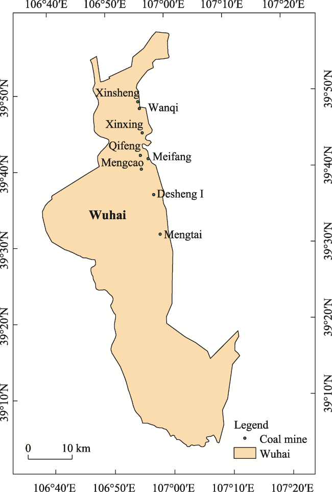
Fig. 1 Location of the waste dump in Wuhai mine and distribution of the individual study sites
Wuhai City is located in the arid desert area, and has the typical continental warm temperate climate. The winter is cold and windy with a large temperature difference between day and night, and the annual average temperature is 9.8 ℃. Precipitation is low and evaporation is high. The average annual precipitation is about 170 mm, but the annual evaporation is up to 3000 mm. The soil types are mainly brown calcium soil, gray desert soil and wind-sand soil. The natural vegetation is sparse and the ecological regulatory ability is weak. The vegetation types in this area are mainly shrubs and grasses, and the vegetation is wind-resistant and drought-tolerant. The main plants are Overlord (Zygophyllum xanthoxylon), sand Artemisia (Artemisia desertorum), Sand date (Calligonum mongolicum), Alkali poncho (Suaeda glauca), Tetrahymena (Tetraena mongolica), Hemerocallis (Helianthemum songaricum) and Saxifrage (Ammopiptanthus mongolicus) (Zhang, 2013; Ma, 2017).

3 Methods

3.1 Experimental standard site selection

From July to September 2020, based on a literature search and field survey, eight representative mine waste dumps were selected for the study, with treatment durations ranging from 1 to 3 years. A total of 44 sample plots were selected from the treated platforms and slopes using the typical sample plot method; and GPS was used to locate and number the sample plots, and to investigate the slope, slope direction, mulch thickness, soil texture, soil hardness, and other site factors (Tian, 2011). The vegetation survey was conducted according to the typical sample plots. Five 5 m×5 m shrub samples and five 1 m×1 m herb samples were obtained from the selected survey sample plots using the five-point sampling method to investigate the types, quantity, and coverage of vegetation in the sample plots.

3.2 Soil sample collection and determination

A soil profile was dug out at the top, middle and bottom of each slope or on the left, middle and right parts of the platform. A total of 500 g of mixed soil samples were collected from 0 to 10 cm of each soil profile, and the sampling was repeated three times. Soil organic matter was determined by the external heat method with the dilution of potassium dichromate; soil total nitrogen was determined by sulfuric acid-perchloric acid digestion; total phosphorus was determined by the HClO4-H2SO4 method; and total potassium was determined by the NaOH fusion-atomic absorption flame method (Bao, 2000).

3.3 Selection of site factors and classification of site types

The sample sites selected for the study area were concentrated in the Haibowan and Hainan areas of Wuhai City, and the waste dump was generally in a north-south direction. According to the field survey and the actual data of soil physical and chemical properties, the elevations of the various parts of the waste dump are not very different, and all of them have irrigation maintenance conditions, but the changes in irrigation method, frequency and irrigation quantity are not very different. Therefore, in this study, the ten factors of microtopography X1 (°), slope direction X2, mulch thickness X3 (cm), soil hardness X4 (mm), soil texture X5 (%), total phosphorus content X6 (g kg-1), total potassium content X7 (g kg-1), organic matter content X8 (g kg-1), number of plant species X9, and life forms X10 were selected. According to the study of Yang Yuping and others on the classification of site types, Spearman’s correlation analysis, principal component analysis, and cluster analysis were used to classify the site types of the sample plots in combination with field surveys.

3.4 Quantification of the site factors

Since the selected site factors include both qualitative and quantitative factors, and the ranges and magnitudes of values are not consistent, this study used a field survey to quantify and standardize the site factors in order to eliminate the influence of the ranges and magnitudes of the values, so that the results are comparable. The quantification of site factors used the degree of influence on the strength of vegetation recovery to assign a score to each factor (Zhao, 2008; Wang et al., 2009; Li et al., 2015) and the quantification of the factors is shown in Table 1.
Table 1 Factor quantification criteria
Quantification X1
(°)
X2 X3
(cm)
X4
(mm)
X5
(%)
X6
(g kg-1)
X7
(g kg-1)
X8
(g kg-1)
X9 X10
2 >35 Platform ≤20 ≤10 1-5 <0.2 <5 <6 <3 Herbal
4 30-35 Sunny slope 5-10 0.2-0.4 5-10 6-10 3-4
6 20-40 10-20 0.4-0.6 10-15 10-20 4-6 Herbal and bush
8 5-30 Semi-sunny and semi-shady and shady-sunny slopes 10-30 0.6-0.8 15-20 20-30 6-11
10 <5 Shady slope ≥40 ≥20 >30 0.8-1 20-25 30-40 >11 Herbal, bush and arbor

3.5 Site quality evaluation

The purpose of site quality evaluation is to determine the degrees of influence of different site conditions on vegetation restoration, and provide a scientific basis for vegetation restoration, rational land use and ecological reconstruction of the site. In this study, according to the special topography of the mine waste dump, the index evaluation system was
established by combining the factors of topography, soil and vegetation. The factor analysis method (Li et al., 2015) was used to quantify and standardize the site factors based on the factor quantification in Table 1 along with the extreme difference standard method, and then the weights of each factor were determined and finally calculate the composite score by the weights. The formula is as follows:
The weighting formula:
Wjj/Σλj
The composite score formula:
Pi=ΣXijWj
where i is the site type; j is the index; λj is the characteristic root of the j-th principal component; Wj is the weight of the j-th principal component; Pi is the comprehensive score of the i-th site quality of the site type; and Xij is the standardized value of the j-th index of the i-th site type.

3.6 Data processing

All data were processed using Excel 2010, SPSS 21. 0, and other software.

4 Results and analysis

4.1 Correlation analysis of site factors in the waste dump

The results of Spearman correlation analysis after quantifying and standardizing the site factors X1-X10 are shown in Table 2. The positive and negative correlations among the various factors included slope direction (8 positive), mulch thickness (2 positive and 5 negative), soil hardness (5 positive and 1 negative), soil texture (4 positive and 1 negative), total phosphorus content (4 positive), total potassium content (3 positive), and number of vegetation species (1 positive). In general, the relationships among most of the 10 factors were positive correlations, and most of the factors were significantly positively correlated.
Table 2 Correlation analysis of site factors in the waste dump
Factors X1 X2 X3 X4 X5 X6 X7 X8 X9 X10
X1 1
X2 -0.703** 1
X3 -0.292 0.272 1
X4 -0.231 0.186 -0.384* 1
X5 -0.323* 0.274 -0.027 0.257 1
X6 -0.080 0.184 -0.126 0.295 0.092 1
X7 -0.423** 0.411** 0.018 0.426** 0.281 0.481** 1
X8 -0.331* 0.387** -0.151 0.312* 0.271 0.183 0.427** 1
X9 -0.343* 0.238 0.188 0.015 0.055 0.247 0.202 0.076 1
X10 -0.184 0.201 -0.002 -0.071 -0.198 0.195 0.132 -0.088 0.312* 1

Note: Site factors X1-X10 represent microtopography, slope direction, mulch thickness, soil hardness, soil texture, total phosphorus content, total potassium content, organic matter content, number of vegetation species, and life forms, respectively. ** indicates a significant correlation at the 0.01 level; * indicates a significant correlation at the 0.05 level.

Among these significant correlations, microtopography was highly significantly negatively correlated (P<0.01) with slope direction and total potassium content, and significantly negatively correlated (P<0.05) with soil texture, organic matter content, and vegetation species number. The largest correlation coefficient was found in slope direction, with a correlation coefficient of -0.703, indicating that different slopes and slope directions represent differences in topography, and there is an inseparable relationship between them. Slope direction was highly significantly and negatively correlated with total potassium content and organic matter content (P<0.01), indicating that as the topography of the platform changed sequentially between sunny slope, half-sunny and half-shady slope, and shady slope, the total potassium content and organic matter content of soil nutrients also increased, improving the soil chemistry and increasing the vegetation species conducive to revegetation of the waste dumps. A significant negative correlation existed between mulch thickness and soil hardness (P<0.05), indicating that the thicker the mulch, the greater the sand content in the soil, resulting in softer soils, faster infiltration of soil water and soil nutrient transport, and improved soil fertility. Soil hardness was highly significantly and positively correlated with total potassium content (P<0.01) and with organic matter content (P<0.05), indicating that as soil hardness increased, the total potassium content and organic matter content of soil nutrients also increased, and this would accelerate soil water infiltration and protection as well as soil nutrient conversion and transport, and favor vegetation root uptake. Overall, the vegetation growth was faster and the vegetation restoration was better for good site conditions in the waste dump, while the opposite was true for poor site conditions in the waste dump.

4.2 Analysis of the dominant factors in the waste dump study

Since the different site factors have varying degrees of effect on vegetation restoration, identifying the dominant factors that most strongly affect vegetation restoration is a prerequisite for classifying the site types of waste dumps. According to the results of the correlation analysis, there are certain correlations among the factors. Therefore, the quantitative and standardized site factors were used to filter out the dominant factors for classifying the site types of the waste dumps by using principal component analysis and the results were combined with the field survey.
According to the results of the principal component analysis, the KMO value of 0.664 (>0.5) and P=0<0.01 in the KMO and Bartlett’s sphericity test indicate that the selected data are suitable for factor analysis. Table 3 shows that the cumulative contribution of the variances of the first three principal components (F1, F2, and F3) obtained according to the eigenvalue>1 extraction method is 61.981%, indicating that these first three principal components represent 61.981% of all the component information and basically contain all of the component information. Therefore, the first three principal components were selected as the important principal components of the characteristic information of the sample site land feature information. Based on the results of the component matrix in Table 4, the relationships between these three principal components and each of the ten factors were constructed as follows:
F1=-0.747X1+0.759X2+0.071X3+0.519X4+0.481X5+0.492X6+0.774X7+0.610X8+0.392X9+0.217X10
F2=-0.333X1+0.335X2+0.762X3-0.602X4-0.241X5-0.189X6-0.145X7-0.307X8+0.429X9+0.440X10
F3=0.286X1-0.200X2-0.344X3+0.100X4-0.457X5+0.640X6+0.143X7-0.194X8+0.376X9+0.401X10
Table 3 Total variance explanations for the site factors of the waste dump
Site factors Principal components
F1 F2 F3
X1 -0.747 -0.333 0.286
X2 0.759 0.335 -0.200
X3 0.071 0.762 -0.334
X4 0.519 -0.602 0.100
X5 0.481 -0.241 -0.457
X6 0.492 -0.189 0.640
X7 0.774 -0.145 0.143
X8 0.610 -0.307 -0.194
X9 0.392 0.429 0.376
X10 0.217 0.440 0.401
Table 4 Characteristic component matrix of the landform factors of the waste dump
Component Initial eigenvalue Extraction of the sum of squares of loads
Total Variance (%) Cumulative (%) Total Variance (%) Cumulative (%)
1 3.055 30.550 30.550 3.055 30.550 30.550
2 1.752 17.522 48.072 1.752 17.522 48.072
3 1.391 13.909 61.981 1.391 13.909 61.981
4 0.836 8.360 70.340
5 0.732 7.325 77.665
6 0.677 6.771 84.436
7 0.579 5.787 90.223
8 0.428 4.283 94.506
9 0.286 2. 858 97.364
10 0.264 2.636 100.000
where site factors X1-X10 represent microtopography, slope direction, mulch thickness, soil hardness, soil texture, total phosphorus content, total potassium content, organic matter content, number of vegetation species, and life forms, respectively.
The results of the principal component analysis of the waste dump site factors showed that the factors of microtopography, slope direction, mulch thickness, total phosphorus content, and total potassium content played the key dominant role in the process of site type classification. According to the field survey results of the waste dump, there are significant differences in topographic and geomorphological conditions between the different sites, and there are significant correlations between the physical and chemical properties of the soil. Mulch thickness plays an important role in soil water conservation and transport, and both are significantly correlated in the correlation analysis with soil nutrient content, which has an important effect on soil fertility. The total phosphorus content and total potassium content of soil nutrients have significant differences in sites and have an impact on the classification of site types. However, since these indexes are difficult to measure directly by means of the field surveys, they are combined with the results of the correlation analysis of site factors, and there is a highly significant correlation between microtopography and slope direction, indicating that the soil nutrient content is affected by topography. Therefore, the factor of soil nutrient content cannot be used as the dominant stand factor for classifying the site type. In summary, the dominant factors for the classification of site types in the Wuhai mine waste dump are microtopography (°), slope direction, and mulch thickness (cm), and the dominant factors are divided into classes (Tian, 2011; Zhang et al., 2014) as shown in Table 5.
Table 5 Grading criteria of the dominant factors of the waste dump
Microtopography Slope direction Mulch thickness
Platform (<5°) Sunny slope (135°-225°) Thin thickness (≤20 cm)
Low slope (5°-30°) Shady-sunny slope (45°-135°, 225°-315 °) Medium thickness (20-40 cm)
Slope (30°-35°) Shady slope (0°-45°, 315°-360°) Deep thickness (≥40 cm)
Steep slope (35°-40°)

4.3 Site type classification in the waste dump

In this study, the systematic clustering method of intergroup linkage in SPSS software was used to classify the site types of the Wuhai mine waste dump by using the squared Euclidean distance as the sample site metric and the Z score scalar for standardization, combined with the dominant factors. According to the clustering analysis results shown in Fig. 2, the 44 typical sample sites of the Wuhai mine waste dump were divided into four site type groups and 14 site types. Based on the classification of the dominant factors, the site type groups were named by their “microtopography” characteristics and the site types were named by their “mulch thickness + microtopography + slope direction” characteristics.
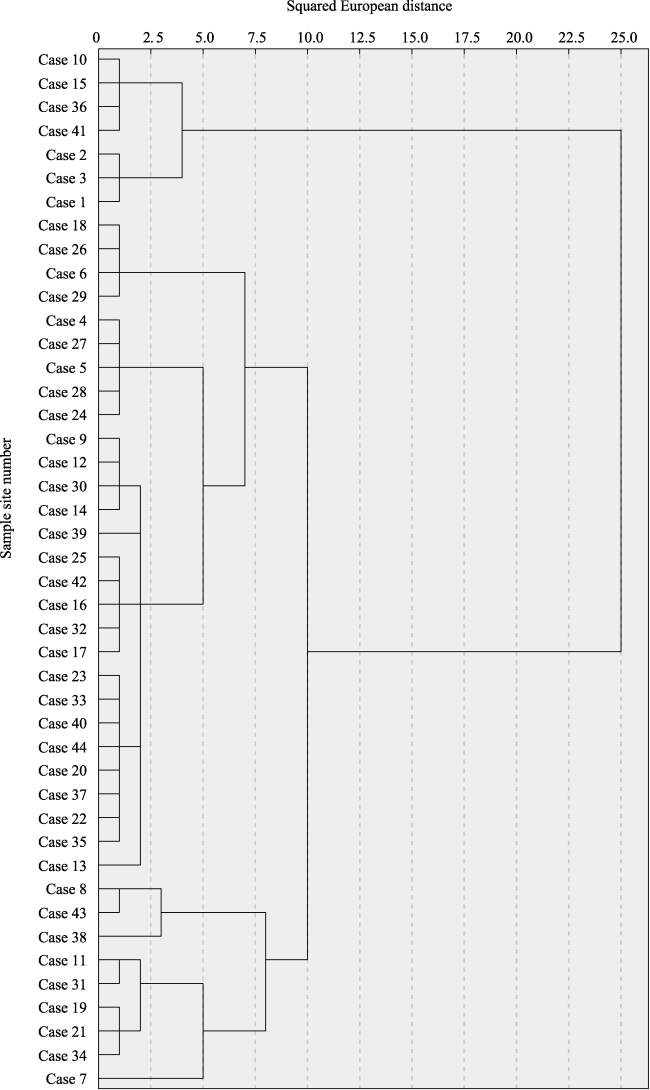
Fig. 2 Cluster analysis tree diagram
According to the data in Table 6, the waste dump of Wuhai mine is divided into four site type groups, i.e., the platform site type group, low slope site type group, slope site type group, and steep slope site type group. Among them, there are two site types of platform: thin thickness platform and medium thickness platform; two site types of low slope: thin thickness low shady-sunny slope and medium thickness low shady-sunny slope; seven site types of slope: thin thickness sloping sunny slope, medium thickness sloping sunny slope, thin thickness sloping shady-sunny slope, medium thickness sloping shady-sunny slope, deep thickness sloping shady-sunny slope, thin thickness sloping shady slope and medium thickness sloping shady slope; and three site types of steep slope: thin thickness steep shady-sunny slope, medium thickness steep sunny slope and medium thickness steep shady-sunny slope.
Table 6 Classification of the site types and their characteristics in the waste dump of Wuhai mine
Site type group Site type Sample site number Site characteristics
Platform site type group Thin thickness platform 10, 15, 36, 4 Slope 0°, mulch thickness 11-16 cm, thin
Medium thickness platform 1, 2, 3 Slope 0°, mulch thickness 23.5-26 cm, medium
Slow slope site type group Thin thickness low shady-sunny slop 27 Slope 29°, shady-sunny slop, mulch thickness 11.5 cm, thin
Medium thickness low shady-sunny slope 25, 17, 13, 44 Slope 28°-29°, shady-sunny slope, mulch thickness 21.5-29.5 cm, medium
Thin thickness sloping sunny slope 18, 26, 6, 29 Slope 32°-35°, sunny slope, mulch thickness 12-19 cm, thin
Medium thickness sloping sunny slope 8, 43 Slope 33°-35°, sunny slope, mulch thickness 33-36.3 cm, medium
Slope site type group Thin thickness sloping shady-sunny slope 4, 5, 24 Slope 31°-33°, shady-sunny slope, mulch thickness 12-16.5 cm, thin
Medium thickness sloping shady-sunny slope 23, 33, 40, 35, 32, 16, 42, 34 Slope 30°-34°, shady-sunny slope, mulch thickness 20.1-33.4 cm, medium
Deep thickness sloping shady-sunny slope 7 Slope 34°, shady-sunny slope, mulch thickness 46 cm, thicker
Thin thickness sloping shady slope 39 Slope 31°, shady slope, mulch thickness 17.7 cm, thin
Medium thickness sloping shady slope 9, 12, 30, 14, 11, 31 Slope 30°-34°, shady slope, mulch thickness 22.5-34 cm, medium
Thin thickness steep shady-sunny slope 28 Slope 36°, shady-sunny slope, mulch thickness 12.5 cm, thin
Steep slope site type group Medium thickness steep sunny slope 38 Slope 39°, sunny slope, mulch thickness 26 cm, medium thickness
Medium thickness steep shady-sunny slope 20, 37, 22, 19, 21 Slope 36°-39°, shady-sunny slope, mulch thickness 20-37.8 cm, medium

4.4 Site quality evaluation in the waste dump

According to the factor quantification table, the data for the 10 factors of the 14 site types were quantified and standardized, and the factor analysis method was used to derive the weights of the site quality evaluation indexes (see Table 7). Finally, the comprehensive scores of the 14 site types were calculated, and based on the index data of the survey sample sites and the actual situation, the site quality scores of the waste dump were divided into four relative levels of excellent (>7), good (6-7), medium (5-6) and poor (<5).
Table 7 Evaluation index weights of site quality
Indicator X1 X2 X3 X4 X5 X6 X7 X8 X9 X10
Weight 0.11 0.12 0.10 0.10 0.08 0.09 0.09 0.08 0.11 0.12
According to the evaluation results for the site quality of the discharge site in Table 8, the medium thickness platform had the lowest score, which was even lower than the “thin thickness platform”. It is generally believed that the thicker the mulch, the better the vegetation growth. However, combined with the sample plots, although both life forms are shrubs and herbs, the number of plant species in the thin thickness platform was up to 17 species. In contrast, the number of medium thickness platform plant species was only nine, so these two are very different from each other, although the chemical properties of the former are all greater than those of the latter. In addition, the field survey showed that mulch thickness in the natural area around the mining area of Wuhai City was basically in the range of 10-20 cm, and combined with the weighting results, the results indicated that the mulch thickness was not the main factor affecting the stand quality. So the site quality grade of the thin thickness platform was higher than that of the medium thickness platform stand. Combined with the actual situation, the site quality grade of excellent (>7) has the best site conditions: mulch thickness in the range of 24-46 cm, thicker, more soil gravel content, medium soil hardness, total potassium content greater than 15 g kg-1, organic matter content greater than 10 g kg-1, better soil physical and chemical properties, a greater number of above-ground vegetation species, vegetation cover greater than 35%, and a good vegetation growth condition. The site quality grade of good (6-7) has average site conditions: mulch thickness in the range of 12-27 cm, thin, more soil gravel content, medium soil hardness, total potassium content more than 15g kg-1, organic matter content more than 10 g kg-1, better soil physical and chemical properties, more above ground vegetation species, vegetation cover in the range of 30%-40%, and an average vegetation growth condition. The site quality grade of medium (5-6) has poor site conditions: mulch thickness in the range of 8-23 cm, thin, less soil gravel content, medium soil hardness, total potassium content in the range of 10-15 g kg-1, organic matter less than 10 g kg-1, poor soil physical and chemical properties, a lower number of above ground vegetation species, vegetation cover less than 26%, and a poor vegetation growth condition. The site quality grade of poor (<5) has poor site conditions: the mulch thickness is 24 cm, which is thicker, the soil gravel content is less, the soil hardness is soft, the soil water retention is poor, the total potassium content and organic matter content are less than 6 g kg-1, which is a very low level, the soil physical and chemical properties are poor, the number of above ground vegetation species is low, the vegetation cover is less than 10%, and the vegetation growth is poor.
Table 8 Evaluation of site type quality in the waste dump of Wuhai mine
Site type Overall score Site quality level
Medium thickness low shady-sunny slope 7.54
Medium thickness sloping shady slope 7.34 Excellent (>7)
Medium thickness sloping shady-sunny slope 7.10
Deep thickness sloping shady-sunny slope 7.06
Medium thickness steep shady-sunny slope 6.72
Thin thickness sloping shady slope 6.28 Good (6-7)
Thin thickness sloping shady-sunny slope 6.22
Thin thickness steep shady-sunny slope 6.00
Thin thickness platform 5.90
Thin thickness low shady-sunny slop 5.84 Medium (5-6)
Thin thickness sloping sunny slope 5.74
Medium thickness steep sunny slope 5.70
Medium thickness sloping sunny slope 5.20
Medium thickness platform 4.96 Poor (<5)

5 Discussion

In recent years, more and more attention is being paid to the construction of ecological civilization, and against the background of the high-intensity sustainable development of coal resources, the ecological restoration of mining areas has become an important task in the construction of ecological civilization in China. The waste dump is a kind of unnatural and loose mountain that is formed in the process of coal mining and causes serious damage to the ecological environment of the mining area, so an important basic step in the ecological restoration of the mining area is the classification and evaluation of the siting type of the mine waste dump. This study classified and evaluated the site types of the managed mine waste dump in Wuhai City, and used correlation analysis, principal component analysis, cluster analysis and factor analysis to classify the different site types and site quality levels, which is basically consistent with the methods used by other scholars for site type classification and site quality evaluation (Li et al., 2015; Yang, 2020).
In order to classify and evaluate the site types in different study areas, it is necessary to combine the regional characteristics of the study areas and choose a suitable index system. In the site type classification in this study, the topography, soil and vegetation factors were selected as the index system from the perspective of vegetation restoration. The results of the correlation analysis showed that the topography, soil and vegetation factors all have significant relationships, indicating that these three are closely related, and the vegetation factor also has an influence on the site type classification, which is basically consistent with the study of Zhang et al. (2014). The correlation analysis also indicated that different slopes and slope directions both represent differences in topography and there is an inextricable relationship between them. The greater the slope, the greater the soil erosion loss due to gravity which results in rainwater scouring that leads to less soil gravel, total potassium, and organic matter contents along with decreases in soil nutrients, and the number of vegetation species. These changes are not conducive to the recovery of vegetation in the waste dump, and they are basically consistent with the study of Yin et al. (2016). In this study, the principal component analysis was used to filter out microtopography, slope direction, and mulch thickness as the dominant factors, and the qualitative and quantitative factors were combined for classifying the waste dump by site type. This approach made the results more intuitive and reasonable, which is basically consistent with the study of Yang (2020), and others. Only by correctly classifying the types of waste dump sites can we better achieve suitable trees for the right place, suitable for the right place of the principle. On this basis, the evaluation of site quality was carried out to distinguish the superior and inferior scores of the stands under different site types in the waste dump, in order to provide more precise guidance for the vegetation reconstruction of the waste dump, and to provide a scientific basis for the future land use level and ecological reconstruction of the mine. However, the evaluation of site quality on forestless land thus far is more focused on abandoned land, highway side slopes, urban destruction hills, and similar sites. Studies on the site quality evaluation of waste dumps are lacking, so it is necessary to borrow from the research experience of site quality evaluation on other forestless lands. For example, Zhao (2008) established the evaluation index system of slope direction, slope position, vegetation cover, slope, elevation, soil water fertility, etc. and used hierarchical analysis to evaluate the site quality of urban destruction hills. Yu and Huang (2012) selected topographic, climatic, soil, biological and other factors to establish an index evaluation system and applied hierarchical analysis to evaluate the site quality of highway slopes. However, the index systems developed by these researchers are designed more for their own study areas and their methods are subjective. The study differs from the others in that the evaluation system was established by selecting topography, soil, vegetation and other factors in combination with the special stand characteristics of a mine waste dump and then objective evaluation methods were used, so its results are more reasonable, which is also basically consistent with the study of Li et al. (2015), and others. In this study, through the investigation of several representative mine waste dump site factors in Wuhai, the site types were classified and evaluated in order to improve the relevance of waste dump vegetation restoration measures, provide theoretical support for the ecological restoration of mine waste dumps, and contribute to the sustainable and healthy development of mine ecological restoration.

6 Conclusions

(1) In this study, a total of 44 typical sample plots of platforms and slopes were selected from the treated mine waste dump in Wuhai City. And a combination of qualitative and quantitative analyses, such as correlation analysis, principal component analysis and cluster analysis, were used to screen out microtopography, slope direction and mulch thickness as the dominant factors. The 44 typical sample sites were then divided into four site type groups and 14 site types, and the naming was based on the classification of dominant factors, and the site types were named according to their “mulch thickness + microtopography + slope direction” characteristics.
(2) Based on the results of the site type classification, factor analysis was used to evaluate the site types quality. According to the weighting results of the site type evaluation indexes, the top weighting values of microtopography, slope direction, number of vegetation species, and life forms indicated that the topography factors and vegetation factors are the two main factors affecting the site types of the mine waste dump in Wuhai. In the results of the Wuhai mine site quality evaluation, the 14 site types were divided into four site quality levels of “excellent”, “good”, “medium” and “poor”. Among these four, the sites with quality grade of excellent (composite score >7) include four site types: medium thickness low shady-sunny slope, medium thickness sloping shady slope, medium thickness sloping shady-sunny slope,deep thickness sloping shady-sunny slope, which have good site conditions such as thicker mulch thickness, as many as 18 vegetation species, good vegetation growth status, and vegetation measures; thus suggesting herbal, bush and arbor type configurations. There are three site types with a good quality score (6-7): medium thickness steep shady-sunny slope, thin thickness sloping shady slope, and thin thickness sloping shady-sunny slope, which have average site conditions such as thin mulch thickness, average numbers of vegetation species, average vegetation growth status, and vegetation measures; thus suggesting bush and arbor configurations. The site quality grade of medium (5-6) includes six site types: thin thickness steep shady-sunny slope, thin thickness platform, thin thickness low shadysunny slop, thin thickness sloping sunny slope, medium thickness steep sunny slope and medium thickness sloping sunny slope, which have poor stand conditions such as thin mulch thickness, a low number of vegetation species, poor vegetation growth state, and vegetation measures; thus suggesting mainly bush and arbor type configurations or bush type configurations. The site quality grade of poor (<5) only includes medium thickness platform, which has poorer site conditions such as thick mulch thickness, and very few vegetation species. Therefore, the vegetation measures for this type are suggested to be arbor type configuration, and herbaceous plants mainly considering annual vegetation, while appropriate fertilization will be needed to maintain water and soil in the short term and improve the nutrient status of the soil. In general, the site quality grades of medium and poor account for 50% of the site types overall, indicating that the site quality of the waste dump in Wuhai mine is below the medium level, which is not conducive to vegetation restoration in the waste dump.
(3) By investigating the vegetation on each site type and combining the results with the site quality grade results, suitable plant species can be selected to accelerate the process of vegetation restoration in the waste dump. Among the sites, where the site quality grade is excellent, the trees are mainly Ulmus pumila and Platycladus orientalis, the bushes are mainly Caragana Korshinskii, Calligonum arborescens, Artemisia desertorum, Ammopiptanthus mongolicus and Sarcozygium xanthoxylon, and the herbals are mainly Halogeton glomeratu, Bassia dasyphylla, Medicago sativa, Chloris virgata, Artemisia scoparia and Setaria viridisl. Where the site quality grade is good, the bushes are mainly Caragana Korshinskii, Calligonum arborescens and Artemisia desertorum, and the herbals are mainly Halogeton glomeratu, Bassia dasyphylla, Chloris virgata, Artemisia scoparia and Setaria viridis. Where the site quality grade is medium, the bushes are mainly Caragana Korshinskii and Calligonum arborescens, and the herbals are mainly Halogeton glomeratu, Chloris virgata, and Setaria viridis. Where the site quality grade is poor, the herbals are mainly Halogeton glomeratu and Chloris virgata.
[1]
Bao S B. 2000. Soil agrochemical analysis. Beijing, China: Agriculture Press.

[2]
Gao Y X. 2015. The site type classification and site quality assessment of opencast dumping site in Haizhou. Journal of Jilin Forestry Science and Technology, 44(1): 11-15. (in Chinese)

[3]
Li D X, Zhao T N, Zhang Y, et al. 2015. Site type classification and evaluation for abandoned quarry at the eastern foot of the northern section of Taihang Mountain. Science of Soil and Water Conservation, 13(2): 112-117. (in Chinese)

[4]
Luo H, Zhao T N, Xie Y S. 2017. Site classification of highway slopes in the east of North China. Scientia Silvae Sinicae, 53(1): 108-118. (in Chinese)

[5]
Ma H. 2017. The heavy metal distribution characteristics of nine kinds desert plants eastern Alxa-western Ordos, Inner Mongolia, China. Diss., Hohhot, China: Inner Mongolia University. (in Chinese)

[6]
Ren Y Y, Han Y L, Liu Z X, et al. 2021. Classification of Mu Us sandy land stands and the election of resistant tree species. Journal of Arid Land Resources and Environment, 35(1): 135-140. (in Chinese)

[7]
Resende R T, Soares A A V, Forrester D I, et al. 2018. Environmental uniformity, site quality and tree competition interact to determine stand productivity of clonal Eucalyptus. Forest Ecology and Management, 410: 76-83.

DOI

[8]
Rolando R, Real P, Espinosa M, et al. 2009. A process-based model to evaluate site quality for Eucalyptus nitens in the Bio-Bio Region of Chile. Forestry, 82(2): 149-162.

DOI

[9]
Teng W C, Wan W S, Wang L H. 2009. Advances in forest site classification and quality evaluation. Guangxi Agricultural Sciences, 40(8): 1110-1114. (in Chinese)

[10]
Tian T. 2011. Study on the site classification of typical slope in Beijing. Diss., Beijing, China: Beijing Forestry University. (in Chinese)

[11]
Wang C, Bi J. 2012. Types classification and ecological degradation characteristics of metal mine wasteland. Environmental Protection Science, 38(1): 41-44, 49. (in Chinese)

[12]
Wang F, Li H L, Dong Z, et al. 2009. Site type division of breakage hill pits and vegetation restoration around city: A case study of Zibo City of Shandong Province. Science of Soil and Water Conservation, 7(1): 92-96. (in Chinese)

[13]
Wang Q. 2009. Study on the characteristics of natural restoration and artifciail ecological restoration of quarry in east China. Diss., Beijing, China: Beijing Forestry University. (in Chinese)

[14]
Wei S Y. 2010. Classifying and estimating for site type of mines wasteland—A case study on the Shouyun Iron Ore in Beijing. Diss., Beijing, China: Beijing Forestry University. (in Chinese)

[15]
Yang Y. 2020. Study on site classification and characteristics of coal mining bases in Lingwu Mining Area, Inner Mongolia, China. Diss., Hohhot, China: Inner Mongolia Agricultural University. (in Chinese)

[16]
Yang Y P, Xu L F, Zheng W D, et al. 2020. Site types and characteristics of Coal Gangue Hill based on vegetation reconstruction in Ningdong Mining Area. Bulletin of Soil and Water Conservation, 40(3): 202-207. (in Chinese)

[17]
Yin H K, Xu H, Li D W, et al. 2016. Typical site type classification and dominant factor analysis of open-pit iron mine. Metal Mine, (6): 173-179. (in Chinese)

[18]
Yu H, Huang J. 2012. Site quality assessment for road slope ecological restoration. Journal of Liaoning Technical University (Natural Science), 31(3): 345-348. (in Chinese)

[19]
Zhang L, Bai Z K, Jing M, et al. 2014. Type classification for vegetation restoration on dump of large opencast coal-mine in loess area—Taking Antaibao Opencast Coal-Mine as an example. Research of Soil and Water Conservation, 21(6): 54-60. (in Chinese)

[20]
Zhang P J, Lu W H, Xu J M, et al. 2021a. Site classification and quality evaluation of Eucalyptus urophylla×E. tereticornis plantation in Hainan Island and Leizhou Peninsula Region. Forest Research, 34(6): 130-139. (in Chinese)

[21]
Zhang W Z. 2013. Investigation and evaluation of bioeconomic resources in Wuhai, a desert hinterland of the Yellow River Basin. Western Resources, (5): 120-121. (in Chinese)

[22]
Zhang X W, Yu Q J, Luo G S, et al. 2021b. Site classification and site quality evaluation of Pinus tabulaeformis plantation for construction timber in Pingquan, Hebei Province. Scientia Silvae Sinicae, 57(9): 1-12. (in Chinese)

[23]
Zhai J. 2019. Classification of micro-site types and site quality evaluation of expressway slopes in central and southern Shandong. Diss., Beijing, China: Beijing Forestry University. (in Chinese)

[24]
Zhao F. 2008. The classification and evaluation of site conditions in damaged mount Sibao in Zibo City, Shandong, China. Diss., Taian, China: Shandong Agricultural University. (in Chinese)

[25]
Zhao T N, Zhang Y X, Cao B, et al. 2018. Eco-security technology for coal mining bases in the northwestern arid desert regions in China. Journal of Soil and Water Conservation, 32(1): 1-5. (in Chinese)

[26]
Zhou Y S, He X H, Xie Y G, et al. 2008. Type classification for vegetation restoration of Karst Mountains in Bijie. Scientia Silvae Sinicae, 44(12): 123-128. (in Chinese)

Outlines

/