Evaluation and Improvement of Mine Site Quality

Limiting Factors and Countermeasures of the Ecological Restoration of the Dump of Open-pit Coal Mine in the Helan Mountains

  • SHI Liutong , 1 ,
  • SHI Changqing , 1, * ,
  • ZHANG Junjiao 2 ,
  • HU Yang 3
Expand
  • 1. School of Soil and Water Conservation, Beijing Forestry University, Beijing 100083, China
  • 2. Yunnan Rural Science and Technology Service Center, Kunming 650021, China
  • 3. Huaxi District Natural Resources Agency, Guiyang 550025, China
*SHI Changqing, E-mail:

SHI Liutong, E-mail:

Received date: 2022-08-25

  Accepted date: 2023-01-10

  Online published: 2023-07-14

Supported by

Key Research and Development Program of China(2017YFC0504406)

The Key Research and Development Program of Ningxia Hui Autonomous Region(2018BFG02002)

Abstract

In order to clarify the ecological restoration direction, this study investigated the limiting factors of the ecological restoration of the dump of Rujigou Open-pit Coal Mine in the Helan Mountain Nature Reserve from the aspects of climate, topography, and soil physicochemical properties. The main results are as follows: (1) In terms of climate, the main limiting factors in the study area were low precipitation (<200 mm) with uneven annual distribution, high evaporation (2000 mm), low temperature, less effective accumulated temperature, and large number of gale days (≥150 days). (2) The topographic limiting factors were steep slope (30°-36°) and long slope length (10-44 m). (3) In terms of soil, the main limiting factors were high contents of sand (73.40%±2.18%) and clay (13.21%±1.37%), low porosity (30.89%±0.83%), and low contents of total nitrogen (0.67±0.05 g kg‒1), hydrolytic nitrogen (14.23±0.48 mg kg‒1) and available phosphorus (2.81±0.44 mg kg‒1). The limiting factors of the ecological restoration of the study area mainly included drought and water shortage, less effective accumulated temperature, large number of days of strong wind, steep slope, long slope length, and soil depletion. In view of the above limiting factors, countermeasures such as slope foot support, slope level arrest and consolidation, slope cover, plant measures, and muck improvement can be considered. This study provides a scientific basis and theoretical support for the selection of appropriate ecological restoration measures and improvement of restoration effectiveness for open-pit mine dumps in arid areas such as the Helan Mountains.

Cite this article

SHI Liutong , SHI Changqing , ZHANG Junjiao , HU Yang . Limiting Factors and Countermeasures of the Ecological Restoration of the Dump of Open-pit Coal Mine in the Helan Mountains[J]. Journal of Resources and Ecology, 2023 , 14(4) : 784 -793 . DOI: 10.5814/j.issn.1674-764x.2023.04.011

1 Introduction

The Helan Mountain National Nature Reserve has rich mineral resources and a mining history of 40 years, with more than 81 enterprises conducting open-pit mining. However, the unreasonable and large number of mining activities coupled with poor awareness on the importance of ecological protection have led to large areas of abandoned mining land and vegetation destruction, without any ecological restoration measures (Liu, 2019). In the reserve, coal mining is still active in the Baijigou and Rujigou coalfields, among which open-pit mining activities have been conducted in the Rujigou coalfield for 30 years. At present, 14 waste dumps and slag platforms as well as other ecologically sensitive areas remain unattended, covering a total area of 493.2 ha. Due to the lack of scientific guidance, vegetation restoration efforts in the mining area are simple, with only artificial seeding or flying seeding being implemented. With these methods, the germination rate and seedling preservation rate of seeds are generally very low, and the coverage of artificial herbaceous vegetation is less than 10%. In the process of strip mining, subsidence areas and artificial loose deposits are formed, which are prone to soil erosion and soil nutrient loss (Zhang, 2009). Coupled with the relatively dry local climate, vegetation restoration is difficult in such mining sites. In abandoned mines, the ecological restoration of dump sites is considered as the key of improving the ecological environment. According to the statistics of open-pit coal mining in China, most mining areas are distributed in the arid area of northwest China. Therefore, research on the dump of Helan Mountain open-pit coal mines in the Helan Mountains has great universal significance. The national and local governments have introduced a series of mine management policies to proceed with the environmental protection of mining areas (Liu, 2019). In response to the call of national policies, the ecological restoration of abandoned mine lands has become one of the research hotspots (Wei et al., 2006).
The ecological restoration of abandoned mining land is a process of assisting the restoration of degraded and damaged ecosystems in mining areas, with the purpose of returning the ecosystem to a state of health, stability, and sustainable development (Liu and Wang, 2019). Limiting factors are factors that limit the growth, development, and distribution of organisms and include environmental factors such as light and temperature in addition to chemicals. Limiting factors usually respond to each other and act together, and their effects may be different in different environments. By identifying environmental limiting factors before ecological restoration, the direction of ecological restoration can be clarified, more targeted restoration measures can be selected, and the efficiency of ecological restoration can be improved. Therefore, the identification of limiting factors is of great significance for the ecological restoration of abandoned mines. At present, Chinese and global research on the ecological restoration of mines mainly focus on restoration strategies, engineering measures, technical screening, matrix improvement, plant species allocation, effect evaluation and other factors (Meira-Neto et al., 2011; Yang et al., 2012; Liu et al., 2015), and specific limiting factors of ecological restoration have rarely been investigated. In the ecological restoration of mines, the main component for restoration is vegetation, and the most relevant ecological factors for vegetation restoration are climatic conditions, topographic characteristics, and soil physicochemical properties. Among them, soil is the main driving force of vegetation growth and succession, thus significantly affecting ecological restoration (Oliveira et al., 2011; Li et al., 2018). However, most previous studies on soil physicochemical properties considered soil classification standards of different regions as reference, ignoring differences in the resilience levels of soils in different regions (Song et al., 2019).
In this study, the limiting factors in the ecological restoration of a dump site were analyzed, taking the Rujigou Mining Area in the Helan Mountains as an example. For the limiting factors, the climate, mine slope characteristics, and soil characteristics of the study area were analyzed. Specifically, the soil characteristics were analyzed with reference to the international classification of soil texture and the second soil census related to the soil nutrient survey standard. In addition, mine residue in soil was compared with the features of the original soil. This study provides theoretical and technical guidance for the ecological restoration of open-pit coal mines in the Helan Mountains.

2 Study area

The experimental site of this study is located in the Rujigou Mining Area (106°52'28"E, 38°52'18"N), Dawukou District, Shizuishan City, Ningxia Autonomous Region, with an altitude of 1824-2118 m. It belongs to the Zhongshan terrain, and the main soil types are sierozem and skeletal soil; the soil layer is thin and the water content is low. The study area has a typical continental climate, with strong solar radiation, large seasonal and diurnal temperature differences, scarce rainfall and low temperature during the dry season, and heavy rainfall and high temperature during the wet season. The rainy season is from June to August. The annual precipitation is less than 200 mm, the annual minimum temperature can reach ‒23.5 ℃, and the annual maximum temperature can reach 35.1 ℃. In spring and winter, the weather is windy, often accompanied by sandstorms, and the main wind direction is W, ENE, and SE, with wind speeds up to 25.05 m s-1. Moreover, the number of days with gales exceeding level six (≥10.8 m s-1) can reach up to 100 days. The vegetation types in the study area are simple, with few plant species. The most common plants are Ammopiptanthus mongolicus, Salsola laricifolia, Lespedeza bicolor, Amygdalus mongolicus Mongolica, Astragalus adsurgens, Agropyron desertorum, Setaria viridis, Halogeton glomeratus, Artemisia ordosica, and other shrub vegetation resistant to drought and barren soil (Shi et al., 2022).

3 Research methods

3.1 Test setting

This study was conducted from May to June 2019. Considering the specification and location of the dump, three sample plots each were selected from the dump site of the Rujigou Open-pit Coal Mine (D1, D2, and D3) and the original land (G1, G2, and G3) with good vegetation growth around the dump. The dump site and the original land were under the same conditions with the same source of dump residue. The geographical locations and basic information of each site are shown in Fig. 1 and Table 1.
Fig. 1 Geographical location map of the study area
Table 1 Location of dump sample site
Sample plot Longitude and latitude Altitude (m) Aspect
D1 106°08′24″E, 39°03′46″N 1982.44 North-west
D2 106°08′11″E, 39°03′55″N 1998.03 North-west
D3 106°08′06″E, 39°02′52″N 2010.87 North-west
G1 106°08′07″E, 39°03′43″N 1915.13 North-west
G2 106°07′55″E, 39°03′41″N 1880.54 North-west
G3 106°07′31″E, 39°02′33″N 1927.25 North-west

3.2 Data sources

3.2.1 Acquisition and calculation of climate data

Meteorological data of the study area, such as precipitation, air temperature, wind, and radiation, covering five years from 2015 to 2019 were acquired from a small weather station in the study area (HOBOware U30) and the weather history archive of Weather Underground (https://www.wunderground.com/weather/cn/beijing). Evapotranspiration was calculated using the Hargreaves method:
$E{{T}_{0}}=0.0023\times \left( {{T}_{\text{mean}}}+17.8 \right)\times \left( {{T}_{\text{max}}}-{{T}_{\text{min}}}^{0.5}\times Ra \right)$
where $E{{T}_{0}}$ is the potential evapotranspiration of reference crops (mm d‒1), Ra is the radiation quantityin the top layer of the atmosphere (MJ (m2 d)‒1), ${{T}_{\text{max}}}$, ${{T}_{\text{min}}}$and ${{T}_{\text{mean}}}$are the maximum temperature, minimum temperature and average temperature (℃) respectively.

3.2.2 Acquisition of topographical data

The original aerial images of the test area were obtained by aerial photography of the test area using a drone (DJI Phantom 4 Pro 2.0). The accuracy of the acquired data were verified through field measurements of slope length, slope, and slope direction using a tape measure, a slope meter, and a compass, respectively.

3.2.3 Measurement of physical and chemical properties of soil

Soil samples were collected from five plots in an “S” shaped pattern. After the soil samples were naturally air-dried, the particle size gradation (sieving method combined with laser particle size analyzer), pH (pH meter), organic matter (potassium dichromate capacity method), total nitrogen (digestion method combined with automatic chemical analyzer), available nitrogen (alkali hydrolysis diffusion method), available phosphorus (molybdenum antimony anti-colorimetric method), and available potassium (flame photometer method) were determined.

3.3 Data processing

Excel 2013 was used to sort out, calculate and map the meteorological data and the experimental data of the physical and chemical properties of the residue. SPSS 22.0 was used to conduct One-way ANOVA for the physical and chemical properties of the soil, and Origin 2021 was used for mapping. Pix4D MAPper 2.0 was used to generate the digital surface model (DSM), digital elevation model (DEM), and digital orthophoto image (DOM), and ArcGIS 10.2 was used to process the above files to obtain the slope length, slope, and aspect of the dump slope.

4 Results and analysis

4.1 Climate factors

Climatic factors mainly include precipitation, temperature, and wind, which are important abiotic factors affecting vegetation growth. As shown in Fig. 2, the average annual precipitation in the study area is less than 200 mm, but the potential evaporation can reach approximately 2000 mm, which is up to 10 times the precipitation. The intense evaporation aggravates the degree of drought in the study area. Moreover, the annual distribution of precipitation is uneven, mainly concentrated in May and July, with little or no precipitation in the remaining months. Therefore, the study area experiences a long dry period. Moreover, occasional heavy rainfall events occur, with precipitation reaching as high as 12.4 mm within 1 h, which is highly conducive to serious soil and water loss. Figure 3 shows that the average annual temperature in the study area is 8.45 ℃, and the average monthly temperature ranges from ‒5.65 to 21.04 ℃. Winter is long in the study area, even starting from the end of October till the end of March the next year. Therefore, the corresponding frost-free period is also short at only approximately 170 days. The annual effective accumulated temperature (temperature ≥10 ℃) is approximately 1249.09 ℃. The field investigation revealed that the plants in the study area generally emerged in April and generally stopped growing at the end of October. The short phenological period in the study area could be primarily attributed to the low temperature and less effective accumulated temperature ≥10 ℃. Figures 4 and 5 show that the average wind speed in the study area ranges from 0.39 m s‒1 to 9.31 m s‒1, with a relatively uniform annual distribution. The dominant wind directions are W, ENE, and SE. The maximum gust wind speed can reach 25.05 m s‒1, and the number of days with gale exceeding level six (wind speed ≥10.8 m s‒1) can reach more than 150 days per year. Strong winds increase drought in the study area by limiting vegetation recovery through mechanical damage to plants and reducing the survivability of seeds and seedlings. They also increase local evaporation.
Fig. 2 Precipitation and potential evaporation of in the study area
Fig. 3 Temperature of study area
Fig. 4 Gust wind and average wind
Fig. 5 Proportion of different wind directions

4.2 Topographic factors

The spatial distribution of vegetation and soil nutrients are closely related to topographic factors. Topographic factors primarily affect plants indirectly by changing light, heat, water, underlying surface, wind, and other conditions (Li et al., 2018). Among the terrain factors, slope, slope length, and slope aspect are commonly used to characterize the terrain. Figure 6 shows that the slope of the dump in the study area is primarily 30°-36°, reflecting a steep slope. According to the Code for Design of Soil and Water Conservation Engineering (GB 51018-2014), the slope of slope-type slag dumping fields should be lower than 25°. According to the Quality Control Standard of Land Reclamation (TD/T1036- 2013), the final slope of the dump should be 26°-28°. The larger the slope, the higher the instability, and the higher the susceptibility to low soil nutrients, soil erosion, and other problems (Yang et al., 2020b). The slope length of the dump in the study area ranges from 10 to 44 m, and the corresponding slope height ranges from 5 to 26 m. Excessively long slopes are prone to soil and water loss and more likely to incur instability issues (Gao et al., 2007). Previous studies have reported a positive correlation between slope length and annual erosion modulus, and that the slope length of sloping farmland should be controlled below 15 m (Wei and Zhu, 2002). According to the “Construction Slope Engineering Technical Code” (GB50330-2013), slopes with heights of 10-15 m correspond to safety grades one and two, for which the failure consequence is very serious and serious, respectively. Therefore, soil slopes with heights greater than 15 m are already relatively unstable. Under this standard, the high dump in the study area is not conducive to ecological restoration. As shown in Fig. 7, the slope direction of the dump in the study area is generally 15°-20° west by north, indicating shady slopes. Slope aspect is not a factor limiting ecological restoration, but has a strong impact on light, temperature, precipitation and wind, and it is the primary factor for consideration when taking vegetation measures (Yang et al., 2020a).
Fig. 6 Slope thematic map
Fig. 7 Aspect thematic map

4.3 Physical and chemical properties of soil

Soil particle size gradation refers to the mass proportion of soil particles with different particle sizes in the soil, and it is an index characterizing the soil texture. As shown in Figure 8, the gravel and clay components of the muck account for a large proportion, with gravel (73.40%±2.18%) accounting for more than 3 times the standard maximum. According to the International Classification of Soil Textures, the opencast coal mine muck of dump, and soil at G1, G2, G3 are heavy gravel (clay), light gravel (sandy clay), multi-gravel (clay), and light gravel (sandy clay), respectively. The clay and sand contents of the residue were significantly higher than those of the original geomorphic soil, while the silt content was significantly lower than that of the original geomorphic soil. In order to verify the accuracy of residuum texture, bulk density, and porosity, repeated experiments were carried out. As shown in Fig. 9, the bulk density of the residual soil was relatively large at approximately 1.55±0.01 g cm-3, which is significantly larger than that of the original shrub land. The total porosity and capillary porosity of the residual soil were both small at approximately 30.39%± 0.83% and 21%±0.98%, respectively, which are significantly lower than those of the original shrub land by approximately 10%. According to the Land Reclamation Quality Control Standard (TD/T1036-2013), the bulk density of mine soil after reclamation should be less than 1.5 g cm‒3, gravel content should be less than 50%, and the soil texture should be sandy or sandy loam. As shown in Table 2, no significant difference was observed between the pH of the residual soil (8.52±0.04) and the original soil (8.45±0.10), which belong to alkaline soil. Similarly, no significant difference was observed in organic matter content between the residual soil (44.87±0.74 g kg‒1) and the original soil (47.00±0.50 g kg‒1). Referring to the nutrient classification standard of the second National Soil Survey, both of them were far beyond the lower limit of the first level standard. The total nitrogen content of the residual soil (0.67±0.05 g kg‒1) corresponds to the fifth grade and is significantly lower than that of the original geomorphic soil (1.47±0.21 g kg‒1). The hydrolytic nitrogen content of residual soil (14.23±0.48 mg kg‒1) corresponds to grade 6 and is significantly lower than that of the original geomorphic soil (40.67±7.99 mg kg‒1). The content of available phosphorus (2.81±0.34 mg kg‒1) in the residual soil corresponds to Grade 5 to 6, without any significant difference from that of the original soil (4.11±0.61 mg kg‒1). The content of available potassium (118.89±5.58 mg kg‒1) in the residual soil significantly differed from that in the original soil (222.67± 92.95 mg kg‒1), but it was high according to the standard.
Fig. 8 Particle size and texture of muck
Fig. 9 Bulk density and porosity
Table 2 Soil index
Sample plot pH Organic matter
(g kg‒1)
Total nitrogen
(g kg‒1)
Alkali-hydrolyzed nitrogen
(mg kg‒1
Available phosphorus
(mg kg‒1
Rapidly available potassium
(mg kg‒1
D1 8.56±0.11a 45.90±2.90a 0.60±0.10c 14.15±0.70e 3.43±0.15b 123.00±11.00b
D2 8.47±0.17a 44.50±1.20a 0.70±0.10c 14.85±0.46e 2.50±0.26b 122.67±20.01b
D3 8.54±0.12a 44.20±6.10a 0.70±0.10c 13.68±0.39d 2.50±0.30b 111.00±5.57b
G1 8.41±0.12a 46.60±4.04a 1.70±0.30a 50.83±5.05c 3.27±0.70b 99.67±23.12b
G2 8.63±0.14a 46.70±16.30a 1.20±0.10b 31.30±71.6b 4.37±1.16ab 244.00±56.15a
G3 8.45±0.16a 47.70±8.60a 1.50±0.20a 39.87±4.86a 4.70±0.66a 324.33±107.50

Note: Different lowercase letters in the table indicated significant differences between different places (P<0.05).

5 Discussion

5.1 Climate limiting factors

Water is an important environmental condition for plant survival. The study area is located in the arid area of northwest China, with scarce natural precipitation. Moreover, with the high altitude and large number of sunny days, this area experiences strong solar radiation, leading to intense evaporation. Even in arid areas, occasional heavy rains can increase the vulnerability of bare slopes to soil erosion and even landslides. In addition to water erosion, wind erosion also contributes to soil and water loss of slopes. Moderate winds facilitate seed and pollen dispersion and promote vegetation restoration. The mining area is affected by monsoon winds, which are often strong (≥10.8 m s-1), and sandstorms, not only exerting damage to plants but also causing erosion of the soil surface. With these characteristics, plant seeds buried at shallow depths are likely to be blown away. In this study, the following climate limiting factors were identified: low amount and uneven distribution of precipitation, heavy rainfall, high evaporation, low temperature, less effective accumulated temperature, and large number of windy days. Among them, low precipitation and high evaporation mainly induce drought and limit the growth of vegetation, heavy rain aggravates the degree of soil and water loss, low temperature and low accumulated temperature mainly lead to short phenological period, and strong winds increase evaporation.
Climate conditions cannot be altered manually. To address the low number of water sources, the utilization rate of precipitation and water infiltration can be increased. In view of the damage to plant seedlings caused by severe evaporation and climate, direct contact between the slope and external elements can be reduced. Therefore, slope cover measures can be adopted to increase the roughness of the slope and reduce the direct contact between the slope and external factors, such that the amount of water infiltrating the soil can be increased, the amount of water evaporating from the soil can be decreased, the temperature of the surface soil on the slope can be increased, and soil erosion caused by heavy rain, large slope, and excessive slope length can be decreased (Lei et al., 2004; Myburgh and Philip, 2013). Commonly used covering materials include stone, wood, and geotechnical materials, among which vegetation blanket, as a new type of slope protection material, is widely used in ecological slope protection because of its low cost, short construction period, easy degradation, and environmentally-friendly and pollution-free characteristics (Gu et al., 2006). At the same time, vegetation measures can be implemented to reduce soil water evaporation, strengthen the stability of shallow slopes, reduce soil erosion, and improve soil physical and chemical properties. In the vegetation survey, the local natural plants were found to be primarily herbaceous, with a coverage rate of 30%-40%. Shrubs were few in number, relatively short in height, and mostly prostrate, and trees were sporadically distributed, most of which were elm and almond (Xiong et al., 2007). In addition, the slope direction of the dump in the study area is dominantly northwest. Therefore, native shrubs suitable for growing on shady slopes should be mainly selected. In conclusion, when taking vegetation measures in the study area, a combination of shrubs and grasses is recommended. Suitable plant species include Halogeton glomeratus, Setaria viridis, and Artemisia desertorum Spreng., and the target vegetation coverage rate should be set at approximately 40%. Previous studies have found that the vegetation coverage, soil moisture, total nitrogen, and available potassium contents of the Rujigou Mining Area significantly increased after setting a vegetation blanket for ecological restoration (Zhang et al., 2022).

5.2 Topographic limiting factors

Microclimate, light intensity, soil moisture, temperature, and evaporation widely vary under different terrain conditions (Bayat et al., 2017; Li et al., 2018), and they directly or indirectly affect abiotic and biotic factors, leading to spatial differences in vegetation and soil conditions (Huang et al., 2015; Méndez-Toribio et al., 2016; Ai et al., 2017; Li et al., 2018). Large slopes are generally prone to slope instability, soil and water loss, soil nutrient loss, texture deterioration, and soil erodibility (Yuan et al., 2017; Mao et al., 2020). Long slopes are prone to serious soil and water loss and slope instability. According to the Technical Specification for Protection and Restoration of Ecological Environment in Mines (Trial) (HJ 651-2013), slope cutting and grading should be carried out when the total height of the dump is greater than 10 m, and the height of each grade should not exceed 8 m, the width should be greater than 2 m, and the slope should be less than 35°. The height of the dump in the study area was 5-26 m, and the slope reached 35°. The topographic limiting factors of the dump slope mainly include excessive slope height and length.
The most direct and effective approach to solving slope steepness and slope length is slope cutting.According to the specification, some dumps in the study area require slope cutting and grading. However, due to the restrictions of road planning, sufficient space is not available for slope cutting and grading. Consequently, it is impossible to directly reduce slope and shorten slope length by cutting and grading. Shortening the slope length is also an effective measure to reduce soil and water loss (Wei and Zhu, 2002). The slope can be divided and upper runoff can be intercepted by setting slope level blocks, such that erosion can be weakened and infiltration increased. The main reason for the susceptibility of open-pit coal mine dumps to soil and water loss is their low consolidation rate (Bjorn et al., 1998). The consolidation rate can be increased via various approaches such as engineering measures, chemical consolidation measures, and vegetation measures. Among the physical methods, geogrid and shotcrete are commonly used. Among chemical consolidation materials, polymer water-absorbing resin cementing materials are widely used owing to their good water retention and consolidation effects (Liang et al., 2016). Consolidation through vegetation is mainly realized by plant roots in three ways: root network series, root soil bonding, and root biochemistry (Liu et al., 1996). At the same time, the Technical Code for Construction Slope Engineering (GB 50330-2013) stipulates that retaining walls can be set at the foot of slopes to increase slope stability. Previous studies have shown that restoration measures such as ecological bag blocking and honeycomb paving have significant effects on improving vegetation coverage, soil water content, total nitrogen and available potassium contents, and the models of vegetation blanket covering and ecological bag blocking present the highest effectiveness for ecological restoration (Zhang et al., 2022).

5.3 Soil limiting factors

Soil provides structural support to plants, and its physical and chemical properties are of great significance for vegetation restoration. According to the common problems encountered in the residual soil of open-pit coal mine dumps, soil texture, bulk density, porosity, pH, organic matter, total nitrogen, hydrolytic nitrogen, available phosphorus, and available potassium were selected as measurement indicators (Pei et al., 
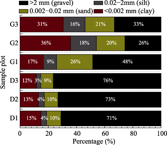
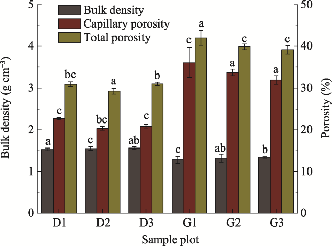
2020). Texture is one of the basic properties of soil and the decisive factor of soil moisture, fertilizer retention capacity, temperature, and tillage. This study shows that the residual soil has some problems, such as high sand and clay contents, large bulk density, and small pores, which are different from the results of previous studies (Li, 2019). The poor quality of the residual soil in the dump may be attributable to the loss of finer particles during the process of mechanical loading and unloading, leaving behind gravel. In the later process of accumulation, the muck is subjected to high gravity impact, as well as heavy transport and repeated rolling, resulting in extremely compact soil. It is inferred that the muck contains large amounts of coal gangue. Owing to its excessive clay content and small pores, the muck is conducive to the formation of a water film after absorbing water, resulting in compaction, poor ventilation, and resistance to water infiltration, while promoting slope runoff and salinization (Liu et al., 2008). Moreover, the residual soil has poor capacity to retain water, fertilizers, and heat because of the high contents of sand and stone, making it more susceptible to the influence of external climate. pH is a basic property of soil and has an important impact on soil texture and nutrients. This study shows that both the residual and original soil are alkaline soil, and the optimal pH of the soil is between 6.5 and 7.5. If the pH is too high, the soil texture will be heavy and sticky, and the structure will be poor, with inappropriate nutrient contents for plant growth (Zhao, 2003; Zhao et al., 2009). The main factors affecting soil pH are soil parent material, climate, vegetation, and human factors (Biro et al., 
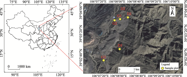
2013). The parent material of soil formation in the Helan Mountain area is mainly gray-calcium soil, which is alkaline, and gray-calcium meadow soil itself is often accompanied by salinization (Jiang et al., 2013). In addition, evaporation is extremely high in the study area, which eventually leads to alkaline residue and high pH of the original soil. Therefore, this study concluded that pH is not a limiting factor for vegetation restoration in the dump site. The main soil nutrients absorbed by plants are nitrogen, phosphorus, and potassium. The total nitrogen content is an indicator of basic soil fertility, which exhibits little change in the short term. Hydrolytic nitrogen, available phosphorus, and available potassium contents mainly reflect the supply of nitrogen, phosphorus, and potassium in the soil in the near future, which fluctuates widely in the short term. This study showed that the content of available potassium was high, and the contents of total nitrogen, hydrolytic nitrogen, and available phosphorus in the residue were low, indicating the depletion of nitrogen and phosphorus in the residual soil. Therefore, hydrolytic nitrogen and available phosphorus were taken as limiting factors for vegetation restoration, which is consistent with the findings of other studies (Ma et al., 2008). Previous studies have shown that due to external disturbance, the substrate of abandoned mining sites often exhibit a lack of organic matter (Ma et al., 2008; Philip et al., 2010), but this study found that the residue of the waste dump has a high content of organic matter. According to the principle of the potassium dichromate volumetric method, which is one of the most commonly used methods for determining soil organic matter content at present, the residual soil has a high carbon content including not only organic carbon, but also coal gangue. However, the high carbon content does not represent a high level of soil fertility because not all carbon can be absorbed and used by plants. In terms of soil characteristics, the main limiting factors are the high contents of silt, sand and clay, and low contents of hydrolytic nitrogen and available phosphorus.
In view of the problem of large sand and stone content in the residuum, the soil screening method can be adopted to reduce the sand and stone content by sifting the residuum. The problem of excessive clay content can be solved by introducing foreign soil (Sun and Wang, 2013). Soil conditioners are widely used to adjust soil physical structure, adjust pH, and reduce heavy metals. Soil carbon, lignite, and weathered coal are rich in humic acid, organic matter, and NPK nutrients, which can effectively improve the soil structure, reduce pH, and increase soil fertility. It should be noted that the standard values in soil physical and chemical property specifications are often the optimal values in large databases, which are not necessarily applicable to every area, and large-scale soil improvement is often subject to many restrictions (Song et al., 2019). Therefore, as long as the physical and chemical properties of the modified residue are close to the standard value, ecological restoration should be successful.

6 Conclusions

On the whole, the limiting factors of the ecological restoration of the dump of the open-pit coal mine in Helan Moutains mainly included drought and water shortage, less effective accumulated temperature, large number of days of strong wind, steep slope, long slope length, and soil depletion. Considering these limiting factors, some recommended measures for ecological restoration are slope foot support, slope level arrest and consolidation, slope covering, vegetation measures, and muck improvement.
[1]
Ai Z M, He L R, Xin Q, et al. 2017. Slope aspect affects the non-structural carbohydrates and C: N: P stoichiometry of Artemisia sacrorum on the Loess Plateau in China. CATENA, 152: 9-17.

DOI

[2]
Bayat H, Sheklabadi M, Moradhaseli M, et al. 2017. Effects of slope aspect, grazing, and sampling position on the soil penetration resistance curve. Geoderma, 303(10): 150-164.

DOI

[3]
Bjorn K B. 1998. Erosion and sediment delivery from peat mines. Soil & Tillage Research, 45(1/2): 199-216.

[4]
Biro K, Pradhan B, Buchroithner M, et al. 2013. Land use/land cover change analysis and its impact on soil properties in the northern part of Gadarif region, Sudan. Land Degradation & Development, 24(1): 90-102.

DOI

[5]
Gao Q, Wang Z Q, Li Z. 2007. Present situation and prospect of vegetation restoration technique in slope of rocky soil. Journal of Yangtze River Scientific Research Institute, 24(5): 20-22, 30. (in Chinese)

[6]
Gu X H, Ding G D, Liu S, et al. 2006. A new bioengineering technique for slope protection in expressway. Research of Soil and Water Conservation, 13(1): 106-107, 180. (in Chinese)

[7]
Huang Y M, Liu D, An S S. 2015. Effects of slope aspect on soil nitrogen and microbial properties in the Chinese Loess region. CATENA, 125: 135-145.

DOI

[8]
Jiang L, Geng Z C, Zhang W, et al. 2013. Soil fertility under different forest types in the Helan and Liupan Mountain ranges of Ningxia Province. Acta Ecologica Sinica, 33(6): 1982-1993. (in Chinese)

DOI

[9]
Kløve B. 1998. Erosion and sediment delivery from peat mines. Soil and Tillage Research, 45(1-2): 199-216.

DOI

[10]
Lei Y P, Hidenori T, Li W Q. 2004. Effects of concrete mulch on soil thermal and moisture regimes. Journal of Agricultural Meteorology, 60(1): 17-23. (in Chinese)

DOI

[11]
Li R R, Zhang W J, Yang S Q, et al. 2018. Topographic aspect affects the vegetation restoration and artificial soil quality of rock-cut slopes restored by external-soil spray seeding. Scientific Reports, 8: 12109. DOI: 10.1038/s41598-018-30651-y.

DOI PMID

[12]
Li X N. 2019. Study on soil properties and revegetation in mining area—A case study of chinese and western mining in inner Mongolia. Diss., Hohhot, China: Inner Mongolia Agricultural University. (in Chinese)

[13]
Liang Z S, Wu Z R, Yang C Q, et al. 2016. Mechanism of erosion resistance and vegetation promotion by W-OH in Pisha sandstone. Journal of Hydraulic Engineering, 47(9): 1160-1166. (in Chinese)

[14]
Liu G B, Jiang D S, Zhu X M. 1996. Study on grasses root bio-mechanics in Loess Plateau. Journal of Soil and Water Conservation, 10(3): 21-28. (in Chinese)

[15]
Liu J G, Wang D Y. 2019. International principles and standards for ecological restoration practice. Beijing, China: Beijing Society of Ecological Restoration. (in Chinese)

[16]
Liu Q S, Liu G H, Zhao J. 2008. The indication function of soil type and soil texture and land type to soil salinization levels. Chinese Agricultural Science Bulletin, 25(1): 297-300. (in Chinese)

[17]
Liu S W, Huang Y Y, Han Z J, et al. 2015. Practices of the soil ecological remediation in ion-abso rare earth mine. Environmental Engineering, 33(11): 160-165. (in Chinese)

[18]
Liu X H. 2019. The era of “macroecology” for mine ecological restoration has come. China Mining News, April 30, 2019.

[19]
Ma C A, Cai Q X, Wang Q R, et al. 2008. Analysis and assessment on quality and fertility of soil at surface mine dumping site. Coal Engineering, 40(5): 77-79. (in Chinese)

[20]
Mao X R, Wang M L, Yang J J, et al. 2020. Effect of coal mining activities on soil properties and erodibility. Southwest China Journal of Agricultural Sciences, 33(11): 2537-2544. (in Chinese)

[21]
Méndez‐Toribio M, Meave J A, Zermeño‐Hernández I, et al. 2016. Effects of slope aspect and topographic position on environmental variables, disturbance regime and tree community attributes in a seasonal tropical dry forest. Journal of Vegetation Science, 27(6): 1094-1103.

DOI

[22]
Meira-Neto J A A, Clemente A, Oliveira G, et al. 2011. Post-fire and post-quarry rehabilitation successions in Mediterranean-like ecosystems: implications for ecological restoration. Ecological Engineering, 37(8): 1132-1139.

DOI

[23]
Myburgh P A. 2013. Effect of shallow tillage and straw mulching on soil water conservation and grapevine response. South African Journal of Plant and Soil, 30(4): 219-225

DOI

[24]
Oliveira G, Nunes A, Clemente A, et al. 2011. Effect of substrate treatments on survival and growth of Mediterranean shrubs in a revegetated quarry: an eight-year study. Ecological Engineering, 37(2): 255-259.

DOI

[25]
Pei X L, Han X L, Qian J L, et al. 2020. Soil fertility assessment indicators from the perspective of natural resources comprehensive observation. Resources Science, 42(10): 1953-1964. (in Chinese)

DOI

[26]
Philip D. Schroeder; W. Lee Daniels; Marcus M. Alley. 2010. Chemical and physical properties of reconstructed mineral sand mine soils in southeastern Virginia. Soil Science, (175): 2-9.

[27]
Schroeder P D, Daniels W L, Alley M M. 2010. Chemical and physical properties of reconstructed mineral sand mine soils in southeastern Virginia. Soil Science, 175(1): 2-9.

DOI

[28]
Shi B, Dou J H, Huang W, et al. 2022. Community characteristics of Ephedra rhytidosperma in Helan Mountain of Ningxia, China. Chinese Journal of Plant Ecology, 46(3): 362-367. (in Chinese)

DOI

[29]
Song G, Liu Y N, Zhang W Q, et al. 2019. Potential of cultivated land quality grade improving promoted by improvable limiting factors. Transactions of the Chinese Society of Agricultural Engineering, 35(14): 261-269. (in Chinese)

[30]
Sun J F, Wang X. 2013. Advance in research and application of soil conditioner. Soil and Fertilizer Sciences in China, 50(1): 1-7. (in Chinese)

[31]
Wei B, Fu M C, Bai Z K, et al. 2006. Dump design for opencast mine based on land-conserving. Transactions of the Chinese Society of Agricultural Engineering, 22(6): 230-232. (in Chinese)

[32]
Wei T X, Zhu J Z. 2002. Effects of slope length and grade on soil erosion in the gully regions in Loess Plateau. Journal of Beijing Forestry University, 24(1): 59-62. (in Chinese)

[33]
Xiong Y M, Xia H P, Li Z A, et al. 2007. Effects and mechanisms of plant roots on slope reinforcement and soil erosion resistance: A research review. Chinese Journal of Applied Ecology, 18(4): 895-904. (in Chinese)

[34]
Yang Z, Fan S X, Zhou R C, et al. 2020a. Leaf function and soil nutrient differences of dominant tree species on different slope aspects at the south foothills of Taihang Mountains. Journal of Henan Agricultural University, 54(3): 408-414. (in Chinese)

[35]
Yang Z C, Zang Z D, Zhang K L, et al. 2020b. Spatial distribution of cropland soil erosion in Guizhou province based on sample data of the first national water census. Science of Soil and Water Conservation, 18(2): 62-68. (in Chinese)

[36]
Yang Z Y, Xue L, Xu J X. 2012. Advances in ecology restoration of abandoned quarries. Acta Ecologica Sinica, 32(16): 5264-5274. (in Chinese)

DOI

[37]
Yuan Y, Zhao Z Q, Bai Z K, et al., 2017. Technology system and method of biodiversity restoration for the reclamation of opencast coal mine: A case study from the dumps in Pingshuo Mine. China Mining Magazine, 26(8): 93-98. (in Chinese)

[38]
Zhang D D. 2009. The vegetation control soil erosion effect and evaluation research of the open-pit dump runoff area. Diss., Fuxin, China: Liaoning Technical University. (in Chinese)

[39]
Zhang J J, Hu Y, Shi C Q, et al. 2022. Changes of vegetation and soil water, temperature and nutrient under different remediation modes in a dump. Science of Soil and Water Conservation, 20(3): 88-93.

[40]
Zhao J, Shen X, Li X, et al. 2009. Correlation between soil pH and the contents of available nutrients in selected soils from Three Pear Orchards in Wendeng. Northern Horticulture, 33(11): 5-8. (in Chinese)

[41]
Zhao J X. 2003. Soil acidity alkalinity and plant growth. Journal of Northern Agriculture, 31(6): 33-42. (in Chinese)

Outlines

/