
Journal of Resources and Ecology >
Construction of a Parameter System for the Near-Natural Topographic Reconstruction of Abandoned Mines in the Arid Desert Region of Northwest China
Received date: 2022-08-20
Accepted date: 2022-12-30
Online published: 2023-07-14
Supported by
Key Research and Development Program of China(2017YFC0504404)
Topographic reconstruction is the fundamental task of the ecological rehabilitation in abandoned mines, which affects the results of the whole ecological system rehabilitation. The technology of near-natural topographic reconstruction constructs the terrain by using the adjacent, undisturbed natural terrains as a reference, and it has become a hot research issue for land reclamation and ecological rehabilitation in recent years. But in reconstructing the near-natural terrain, one must first determine what kinds of characteristics of the natural terrain should be referred to, what necessary parameters should be used, and what indexes should be used to evaluate the results of the topographical design. All these issues still have not been investigated systematically. In this study, the arid desert region in Northwest China was taken as the target area and the theoretical analysis tool of the “Grounded Theory” was applied to discuss these issues systematically. Based on a large amount of literature research and the records obtained from the semi-structured interviews of 12 experts, a three-level parameter system for the near-natural topographic reconstruction in the abandoned mines was finally constructed by three-level coding using the method of the “Grounded Theory”. The parameter system contains a total of three main categories, eight sub-categories, and 26 parameters. The parameters developed in the system can support all aspects of the near-natural terrain design processes, and they can cover the parameter needs in multiple aspects of the topographic reconstruction of the mining sites. This work can provide support for further research on the methods of near-natural topographic reconstruction and improve its technical system.
YANG Gang , SONG Tongtong , ZHANG Chengliang . Construction of a Parameter System for the Near-Natural Topographic Reconstruction of Abandoned Mines in the Arid Desert Region of Northwest China[J]. Journal of Resources and Ecology, 2023 , 14(4) : 733 -743 . DOI: 10.5814/j.issn.1674-764x.2023.04.006
Table 1 Parameters obtained from open coding |
| Category | Parameters |
|---|---|
| Influence of the reconstruction regions | Disturbance degree of reconstruction region to the watershed (abbr. DDRRW) (6) |
| Geomorphological features of the watershed | Drainage density (10); Elevation difference of watershed (10); Average watershed slope (10); Main channel length (8); Watershed area (7); Watershed roundness (7) |
| Channel characteristics | Channel gradient (10); Channel sinuosity (10); Width of the bottom channel (10); Width-to-depth ratio of the channel (10); Minimum distance from the watershed to the source of the channel (9) |
| Slope characteristics | Slope (10); Slope length (6) |
| Parameters related to terrain complexity | Relief amplitude (6); Terrain roughness (5) |
| Soil-related parameters | Material composition of the surface (10); Soil texture (8); Thickness of the soil layer (7) |
| Precipitation-related parameters | 1-hour maximum precipitation once in 2 years (2-yr, 1-hr) (8); 6-hour maximum precipitation once in 50 years (50-yr, 6-hr) (8) |
| Wind-related parameters | Dominant wind direction (8); Dominant wind speed (8); Duration of dominant wind (7) |
| Engineering-related parameters | The natural angle of repose (7); Maximum angle of construction safety (9) |
Note: The number in parentheses indicates the number of experts who recommend the parameter. |
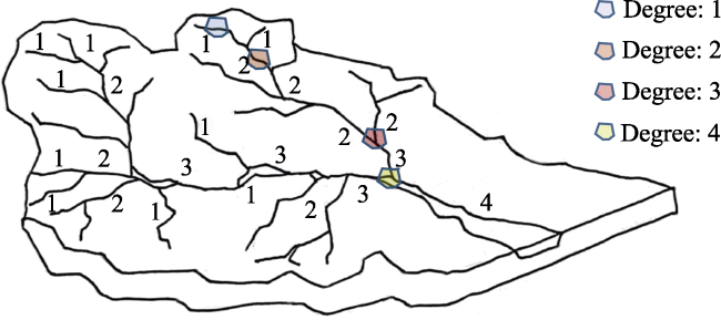
Table 2 Disturbance degree of the reconstruction region to the watershed |
| Description of classification | Degree |
|---|---|
| The reconstruction region lies in the mainstem of the watershed, or at the confluence of tributaries with the mainstem | 4 |
| The reconstruction region lies in multiple non-order Ⅰ channels of the watershed, exclusive to the confluence of the mainstem | 3 |
| The reconstruction region lies in the non-order Ⅰ channel of the watershed or the confluence of an order Ⅰ channel with another tributary | 2 |
| The reconstruction region lies in the order Ⅰ channel of the watershed | 1 |
Fig. 1 Disturbance degree of the reconstruction region to the watershed |
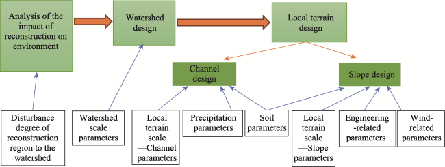
Table 3 Parameter system constructed by axial coding |
| Main category | Sub-category | Parameters | Remarks |
|---|---|---|---|
| Natural terrain characteristics | Watershed scale | Watershed area; watershed roundness; drainage density | Surface-domain characteristics |
| Main channel length | Line-domain characteristics | ||
| An elevation difference of the watershed; average slope | Relief characteristics | ||
| Local terrain unit scale | Sinuosity; minimum distance from the watershed to the source of the channel | Channel planar characteristics | |
| Channel gradient | Characteristics of channel longitudinal section | ||
| Width of the bottom channel; the width-to-depth ratio of the channel | Characteristics of channel cross-section | ||
| Slope, slope length | Slope characteristics | ||
| Terrain complexity | Relief amplitude | Vertical characteristics | |
| Terrain roughness | Horizontal characteristics | ||
| Environmental characteristics | Soil | Material composition of the surface; soil texture; thickness of the soil layer | |
| Precipitation | 2-yr, 1-hr | Determination of the width and cross-section of the channel bank | |
| 50-yr, 6-hr | Determination of the morphology and cross-section of the dominant channel | ||
| Wind | Dominant wind direction; dominant wind speed; duration of dominant wind | ||
| Parameters related to the reconstruction region | Influence of the reconstruction regions | Disturbance degree of reconstruction region to the watershed (abbr. DDRRW) | |
| Engineering-related | Natural angle of repose | ||
| Maximum angle of construction safety |
Note: 1-hour maximum precipitation once in 2 years (abbr. 2-yr, 1-hr); 6-hour maximum precipitation once in 50 years (abbr. 50-yr, 6-hr). |
Fig. 2 Analysis of the parameter system based on the design process |
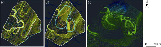
Fig. 3 Topographic reconstruction of the gangue dump in the first district of Yangchangwan Coal Mine. (a) Contour map of the gangue dump before reconstruction; (b) Designed channels, where the orange lines represent the designed channels; (c) Generated topography after reconstruction based on the GeoFluvTM model |
| [1] |
|
| [2] |
|
| [3] |
|
| [4] |
|
| [5] |
|
| [6] |
|
| [7] |
|
| [8] |
|
| [9] |
|
| [10] |
|
| [11] |
|
| [12] |
|
| [13] |
|
| [14] |
|
| [15] |
|
| [16] |
|
| [17] |
|
| [18] |
|
| [19] |
|
| [20] |
|
| [21] |
|
| [22] |
|
/
| 〈 |
|
〉 |