
Journal of Resources and Ecology >
Mining Rights Setting of Open-pit Coal Mines based on GIS and Environmental Impacts in Arid Areas
|
AI Xianfeng, E-mail: 1020600298@qq.com |
Received date: 2022-10-17
Accepted date: 2023-04-13
Online published: 2023-07-14
Supported by
Key Research and Development Program of China(2017YFC0504403)
Mongolia Autonomous Region Science and Technology Major Project(2020ZD0021)
With the increasing proportion of open-pit coal mining in the coal mining industry in China, a series of potential safety hazards, environmental pollution, ecological damage and other problems caused by open-pit coal mining have attracted a great deal of attention. Scientifically determining the appropriate mining right scope of an open-pit coal mine can prevent various problems caused by coal mining from the source. In this study, according to the characteristics of open-pit coal mining and the environmental characteristics in arid areas, 15 indicators were selected and their weights were determined from the three perspectives of geological environment, social environment and ecological environment by using the AHP. Based on the spatial analysis function of ArcGIS, a digital evaluation model was established for the corresponding influencing factors, and a comprehensive evaluation model for setting the mining right range was constructed by superimposing the weights. Finally, four mining areas were identified within the study area in Wuhai, Inner Mongolia, and their ecological values were calculated to determine the mining area with the lowest ecological impact.
Key words: GIS; open-pit coal mine; mining right setting; environmental impact
AI Xianfeng , SHI Changqing , YANG Jianying , ZHANG Yanqing . Mining Rights Setting of Open-pit Coal Mines based on GIS and Environmental Impacts in Arid Areas[J]. Journal of Resources and Ecology, 2023 , 14(4) : 717 -726 . DOI: 10.5814/j.issn.1674-764x.2023.04.004
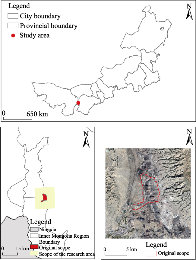
Fig. 1 Research area map |
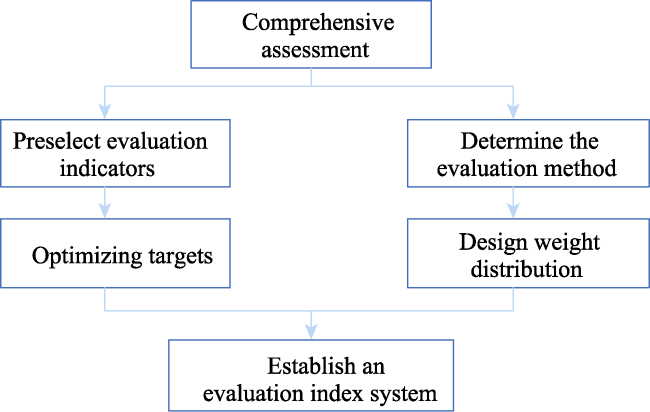
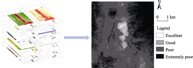
Fig. 2 Process for construction of the final evaluation system |
Table 1 Index system for setting the mining right scope |
| Target layer | Criterion layer | Indicator layer |
|---|---|---|
| Establishment of the mining right of an open-pit coal mine | Geological safety environment (B1) | Geological structure (C11) |
| Topographic features (C12) | ||
| Hydrogeology (C13) | ||
| Lithological characteristics (C14) | ||
| Ramp structure (C15) | ||
| Coal seam hosting (C16) | ||
| Social environment (B2) | Ground features (C21) | |
| Transportation conditions (C22) | ||
| Hydroelectric conditions (C23) | ||
| Noise pollution (C24) | ||
| Ecological environment (B3) | Coal dust pollution (C31) | |
| Water pollution (C32) | ||
| Ecological function zoning (C33) | ||
| Land occupation and damage (C34) | ||
| Vegetation cover (C35) |
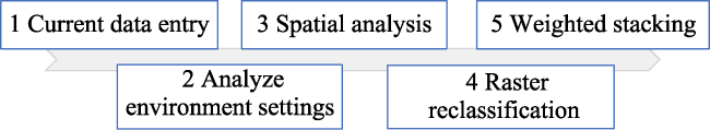
Fig. 3 Information interpretation and evaluation model building ideas |
Table 2 Comparison of product sales revenue and product sales profit between the coal industry and national industrial enterprises |
| Year | Coal industry | National industrial enterprises | |||
|---|---|---|---|---|---|
| Sales revenue | Total profit | Coal output | Sales revenue | Total profit | |
| 2016 | 22328.5 | 1159.5 | 33.6 | 1158998.5 | 71921.4 |
| 2017 | 24870.6 | 2952.7 | 34.5 | 1133160.8 | 74916.3 |
| 2018 | 24645.8 | 2888.2 | 36.8 | 1049490.5 | 66351.4 |
| 2019 | 21990.1 | 2837.5 | 38.5 | 1067397.2 | 65799 |
| 2020 | 20821.6 | 2221.6 | 39 | 1083658.4 | 68465 |
| Average | 22931.3 | 2411.9 | 36.5 | 1098541.1 | 69490.6 |
Note: Data sources: China Statistical Yearbook and China Mineral Resources Report from 2016 to 2020. The units in the table are in billions of yuan. |
Table 3 ESV coefficients of the various land use types in western Inner Mongolia |
| Ecological service function | Cultivated land | Woodland | Grassland | Bare ground | Industrial and mining land | Waters |
|---|---|---|---|---|---|---|
| Gas conditioning | 718.87 | 1512.85 | 2113.69 | 118.02 | 826.16 | |
| Climate regulation | 386.26 | 4538.54 | 5590.02 | 107.29 | 2457.03 | |
| Food supply | 912.00 | 203.86 | 407.72 | 10.73 | 10.73 | 858.35 |
| Water conservation | 289.69 | 3594.35 | 4098.63 | 225.32 | ‒8057.78 | 109697.39 |
| Soil conservation | 1105.13 | 1845.46 | 2575.06 | 139.48 | 21.46 | 997.83 |
| waste disposal | 107.29 | 1373.36 | 1845.46 | 332.61 | ‒2639.43 | 5954.82 |
| Bio-diversity | 139.48 | 1684.52 | 2339.01 | 128.75 | 364.80 | 2027.86 |
| Aesthetic landscape | 64.38 | 740.33 | 1030.02 | 53.65 | 10.73 | 2736.00 |
| Raw material production | 429.18 | 461.36 | 600.85 | 32.19 | 246.78 | |
| Total | 4152.28 | 15954.62 | 20600.45 | 1148.05 | ‒10289.49 | 125802.22 |
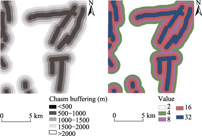
Fig. 4 Digital fault modelNote: Please refer to Table 4 for the value information in the right. |
Fig. 5 Digital hydrological modelNote: Please refer to Table 4 for the value information in the right. |
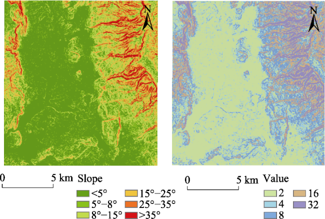
Fig. 6 Digital slope modelNote: Please refer to Table 4 for the value information in the right. |
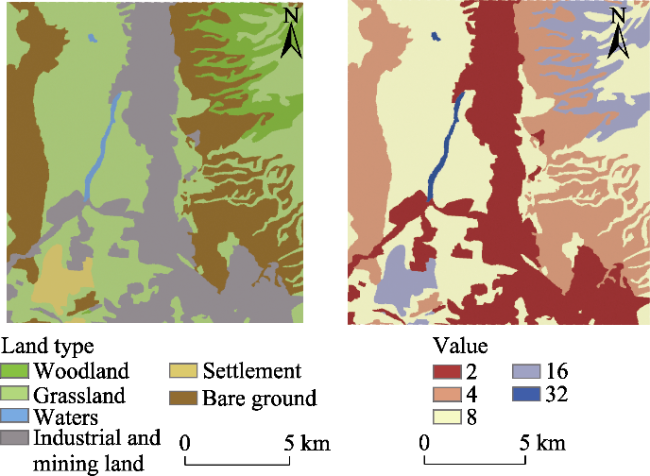
Fig. 7 Digital land modelNote: Please refer to Table 4 for the value information in the right. |
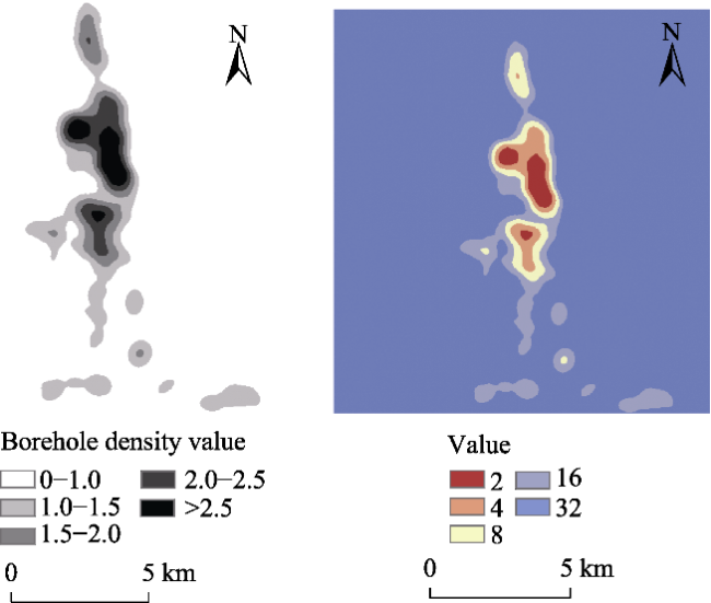
Fig. 8 Digital drilling modelNote: Please refer to Table 4 for the value information in the right. |
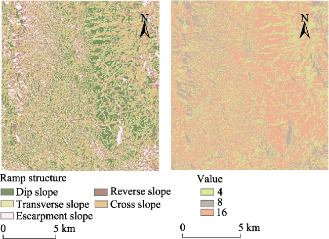
Fig. 9 Digital ramp structureNote: Please refer to Table 4 for the value information in the right. |
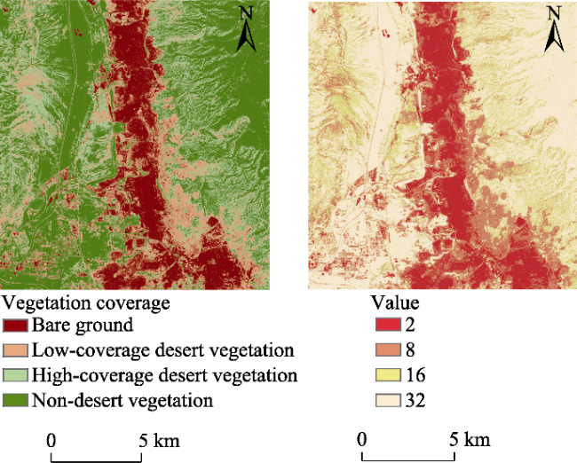
Fig. 10 Digital vegetation modelNote: Please refer to Table 4 for the value information in the right. |
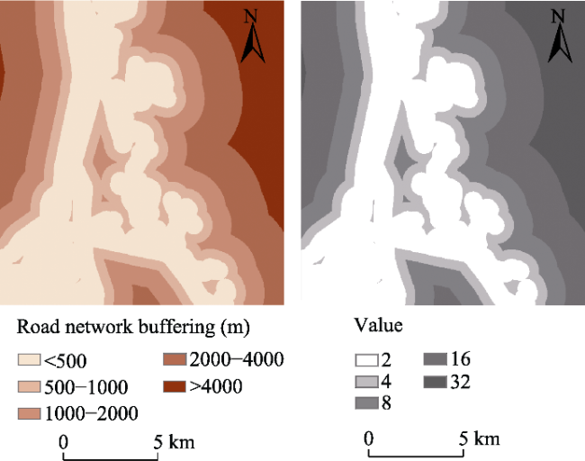
Fig. 11 Digital road network modelNote: Please refer to Table 4 for the value information in the right. |
Table 4 Assignments of the evaluation factors for the mining rights setting model |
| Influence factor | Evaluating indicator | Evaluation and assignment of evaluation factors for the mining right setting model | Weight | ||||
|---|---|---|---|---|---|---|---|
| Excellent | Good | Moderate | Poor | Extremely poor | |||
| Geological safety | Borehole density | >2.5 holes km-2 | 2‒2.5 holes km-2 | 1.5‒2 holes km-2 | 1‒1.5 holes km-2 | <1 holes km-2 | 0.1394 |
| Distance from fault | >2000 m | 1500‒2000 m | 1000‒1500 m | 500‒1000 m | <500 m | 0.0782 | |
| Hydrology | Ramus | Other | Trunk | 0.0962 | |||
| Ramp structure | Transverse slope | Escarpment slope | Dip, cross and reverse slope | 0.0321 | |||
| Slope | <5° | 5°‒8° | 8°‒15° | 15°‒25° | >25° | 0.0827 | |
| Social environment | Ground features | Other than rigid factors | Within the rigidity factors | 0.0952 | |||
| Distance from road | <500 m | 500‒1000 m | 1000‒2000 m | 2000‒4000 m | >4000 m | 0.0476 | |
| Ecological environment | Land occupation and damage | Industrial and mining land | Nudity | Grassland | Forest land, residential area | Water area, cultivated land | 0.1405 |
| Ecological functional area | General important area | Important area | Extremely important area | 0.1119 | |||
| Vegetation cover | Low coverage | Middle coverage | High coverage | 0.1761 | |||
| Assignment | 2 | 4 | 8 | 16 | 32 | 1 | |
Fig. 12 Evaluation diagram of the scope of mining rights |
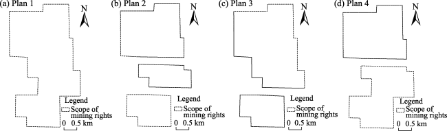
Fig. 13 Mining right scope setting scheme |
Table 5 Benefit estimation of the mining rights scope setting scheme |
| Types | Number of mineral rights (piece) | Recoverable reserves | Total value of reserves | Land compensation | Atmospheric control | Water pollution control | Ecosystem service value | Benefit |
|---|---|---|---|---|---|---|---|---|
| Plan 1 | 1 | 5150.0 | 188071.8 | 31724.0 | 48976.5 | 66435.0 | 16981.0 | 23955.3 |
| Plan 2 | 2 | 4858.2 | 177415.7 | 29926.6 | 46201.7 | 62670.7 | 15903.9 | 22712.8 |
| Plan 3 | 3 | 4559.3 | 166500.2 | 28085.5 | 43358.9 | 58815.0 | 15498.9 | 20741.9 |
| Plan 4 | 2 | 4851.1 | 177156.3 | 29882.8 | 46133.9 | 62579.2 | 16612.1 | 21948.0 |
Note: The unit of the benefit estimation is 10000 yuan. |
| [1] |
|
| [2] |
|
| [3] |
|
| [4] |
Inner Mongolia Autonomous Region Quality and Technical Supervision Bureau. 2009. Inner Mongolia Autonomous Region Industry Water Quota Standrad (DB15/T385-2003). Hohhot, China: Inner Mongolia Autonomous Region Quality and Technical Supervision Bureau. (in Chinese)
|
| [5] |
|
| [6] |
|
| [7] |
|
| [8] |
|
| [9] |
|
| [10] |
|
| [11] |
|
| [12] |
|
| [13] |
|
| [14] |
|
| [15] |
|
| [16] |
|
/
| 〈 |
|
〉 |
