Ecotourism

Spatial Structure and Geographical Characteristics of Tourist Towns in the Wuling Mountain Area

  • TAO Hui , 1 ,
  • HE Yueming 1 ,
  • RAN Feixiao 2 ,
  • JIANG Xu 1 ,
  • ZHANG Panpan , 1, *
Expand
  • 1. School of Management, Minzu University of China, Beijing 100081, China
  • 2. Tung Wah Senior High School, Dongguan, Guangdong 523000, China
*ZHANG Panpan, E-mail:

TAO Hui, E-mail:

Received date: 2022-01-01

  Accepted date: 2022-08-11

  Online published: 2023-04-21

Supported by

The National Natural Science Foundation of China(41901180)

Abstract

As an important form of the new urbanization, tourist towns have become an emerging hotspot for rural revitalization and upgrading of the tourism industry, which has attracted considerable attention. Based on the geographic coordinates of tourist towns, this study uses the nearest neighbor index, geographic concentration index, location entropy and other research methods to quantitatively analyze the spatial distribution characteristics of 289 tourist towns in the Wuling Mountain area and summarize the influencing factors. The results show that the number of tourist towns varies by region, as does the level of tourism development. The distribution of tourist towns generally shows a certain degree of geographical concentration, forming multidensity centers and a large number of small settlements. The tourist towns are obviously distributed along the traffic routes due to the good traffic accessibility and different tourist towns have their own distribution types. Regarding the influencing factors, the spatial distribution of tourist towns is jointly determined by geographic environment, social factors, tourism resources and culture and policies. By analyzing the spatial characteristics of tourist towns and their influencing factors in the Wuling Mountain area, this article provides ideas for exploring the temporal and spatial differentiation of tourist towns around the world and constructing synergistic mechanisms of factors between regions.

Cite this article

TAO Hui , HE Yueming , RAN Feixiao , JIANG Xu , ZHANG Panpan . Spatial Structure and Geographical Characteristics of Tourist Towns in the Wuling Mountain Area[J]. Journal of Resources and Ecology, 2023 , 14(3) : 644 -655 . DOI: 10.5814/j.issn.1674-764x.2023.03.018

1 Introduction

In the early 1980s, the sociologist Fei Xiaotong (Fei, 2015) put forward the idea of “small town, big strategy”, which promoted the comprehensive development of China’s urban system. Later, the central government of China took the strategy of rural revitalization and the development of towns to a new level in 2018. Advancing rural economic growth and building beautiful villages are important measures for China’s supply-side structural reform and further development, and they are designed to facilitate the convergence of three economic sectors, bolster the integration of urban and rural areas, and improve rural governance, thereby achieving high-quality development. With the entry of handicrafts, retail trade, culture and tourism industries, rural areas are showing a non-agricultural trend. Meanwhile, a large number of unique and diverse tourist towns have emerged, which has revitalized the rural economy and rescued many villages from decline, creating a new model for ensuring the economic and social sustainability in rural areas.
As an important type of new urban system development in the new situation, the research on the spatial structure features of tourist towns has gradually gained attention. Scholars at home and abroad have explained the spatial structure characteristics of tourist towns mainly from two aspects. The first aspect is to use the spatial structure and distribution law of tourist towns in order to analyze the spatial distribution of tourist towns (Chen and Pan, 2014; Zhang et al., 2019), spatial reconstruction (Dickson, 2012; Wu et al., 2017; Yang et al., 2020), and spatial structure integration and regulation (Guo et al., 2017; Choung, 2019). The second aspect is to reveal the evolutionary process of the spatial structure of tourist towns through conceptual research on the evolutionary features of the spatial structure of tourist towns (Lu et al., 2014; Sun and Wang, 2017). Other research contents have generally focused on the construction of ecological networks of landscapes (Wu and Lv, 2014), landscape pattern simulation (Fan et al., 2013), the spatial distribution of tourism public service systems (Dou et al., 2013), and similar issues. Although some scholars have begun to pay attention to the spatial distribution characteristics of tourist towns in different regions in recent years, and have analyzed their influencing factors, they have not conducted in-depth research or presented discussions on the spatial distribution features and influencing factors of different types of tourist towns. For the research scale, current studies mainly focus on the micro-scale of an individual tourist town, so there is a lack of studies on the in-depth exploration of the meso- and macro-scale tourist towns. In terms of research methods, most of the spatial research of tourist towns mainly uses qualitative description analysis, supplemented by econometric models for quantitative evaluation, and puts forward development strategies and suggestions. Although the research on tourist towns by Chinese scholars started relatively late, it was endowed with a privileged position for independent development at the outset. Since those towns are a vital component of the road toward urbanization with Chinese characteristics, it is different from western scholars who regard the study of towns as an appendage of the urban functional school of research (Li, 
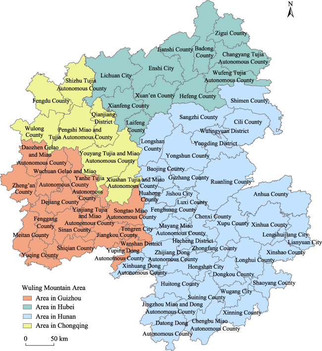
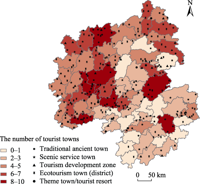
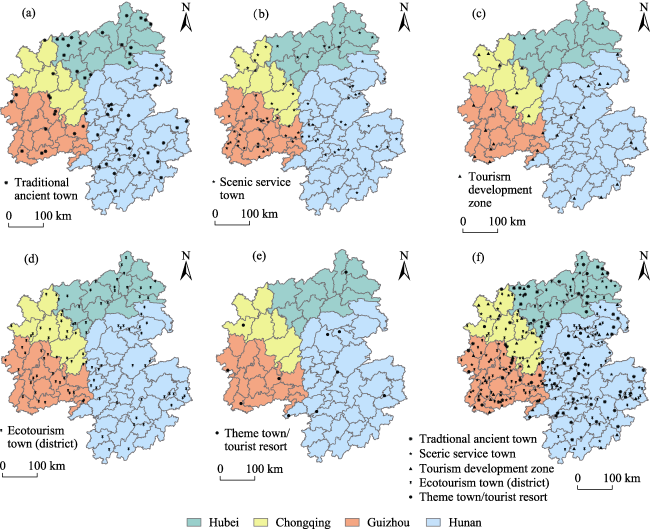
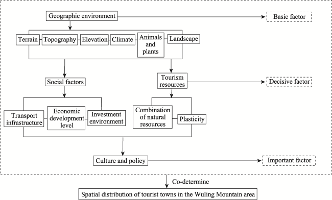
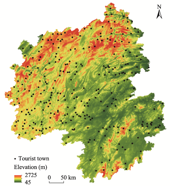
2010). Therefore, this study takes the tourist towns in Wuling Mountain as the research object, and divides them into five categories: Traditional ancient town, Ecotourism (zones) town, Tourism development zone, Scenic service town, and Theme town/tourist resort. Quantitative analysis is used to explore the spatial distribution characteristics and influencing factors among the different types of tourist towns at the medium and macro levels, in order to fill the gaps in the existing research and explore a path for the development of tourist towns with Chinese characteristics.
The Wuling Mountain area is characterized by “minorities” (a high concentration of ethnic minorities), “marginalization” (marginal or remote areas), “poverty” (economically backward), and “richness” (rich ecological and cultural resources). It has witnessed changes in the internal and external environment that appeared with the acceleration of modernization, and then the dilemma between inheritance and renewal developed. In recent years, the rapid development of tourism in the country has reduced the pressure of traditional industry in the Wuling Mountain area, provided multiple opportunities for the urbanization of local areas and alleviated the vulnerability caused by the singular livelihood, making it a leading area for tourism development in the central and western regions of China, a demonstration area for tourism poverty alleviation policies, and an important economic cooperation area. Local tourist towns with abundant resources, diverse types, and great research value have sprung up like mushrooms.
With the upsurge in the construction of tourist towns, many problems have also been exposed. Rapid urbanization has led to the enormous growth of urban projects which will have a negative impact on the originally stable human-land system (Chen et al., 2020), creating new poverty and ecological crises (Tao et al., 2020). Therefore, an in-depth study of the concentrated development of tourist towns is greatly needed. A survey of this field revealed that most of the studies are mainly limited to a single case or type, while few have been conducted on a regional scale with multiple types of tourist towns due to the lack of statistical data and a systematic understanding based on empirical investigations. At this point, three of the unanswered questions are: How have the different types of tourist towns within a homogeneous geographic space developed? What are their rules of spatial layout? What kinds of natural, social and cultural factors affect and restrict them? These problems are worthy of additional regional research on the overall patterns. Based on the National Ethnic Affairs Commission's research project on ethnic issues, this study explores the spatial characteristics of different tourist towns on a medium scale. Through a thorough investigation on the development paths of tourist towns in the Wuling Mountain area, combined with the present research results on the characteristics of tourist towns, details are provided to illustrate the correlations between spatial patterns and development factors so that the academic community and policy makers will have a more comprehensive understanding of the relationships between tourist towns and geographic space. This improved understanding will generate better advice for future strategic cooperation in tourism and sustainable economic development of the national strategic highlands.

2 Research methods and data sources

2.1 Overview of the study area and data sources

Topographically, China descends from the west to the east and forms a three-step staircase according to altitude. The Wuling Mountain area is located in the transition zone from the first step to the second step, including 71 counties (cities and districts) at the border areas of Hubei, Hunan, Chongqing and Guizhou. Among them, there are 11 counties and cities in Hubei, 37 counties and cities in Hunan, 7 counties and cities in Chongqing, and 16 counties and cities in Guizhou (Fig. 1), with a total land area of 1.718×10⁵ km2. The complex natural geographical environment, unique multi-ethnic cultural landscape and rich tourism resources have brought great potential for the development of tourism and created a variety of tourist towns, which provides a good foundation for the new urbanization of the Wuling Mountain area. The basic data of administrative divisions, DEM and traffic line vectors of the Wuling Mountain area used in this study came from the 1:1000000 scale basic geographic database of the National Catalogue Service for Geographic Information. The field research was conducted from April 2015 to June 2017, during which the authors visited eight counties in Enshi Prefecture, Hubei Province and Wulingyuan County, Hunan Province. In addition, other information about tourist towns was collected by consulting local chronicles, statistical yearbooks, and the official websites of governments at all levels and tourism bureaus. The geographical coordinates of the 289 tourist towns identified were obtained through Google Earth pro.
This study adopted the conclusions of the article “The Classification, evaluating and the development models of the tourist towns” (Tao et al., 2015), published in “Scientia Geographica Sinica”. According to the classification method based on A (attraction) - T (towns) - R (rural environment), the tourist towns were divided into five types: traditional ancient towns, scenic service towns, ecotourism zones, theme (resort) towns and tourism development zones (leisure clusters).

2.2 Research methods

This study used ArcGIS 10.3 spatial analysis, and selected the nearest neighbor index, geographic concentration index and location entropy to quantitatively analyze the spatial distribution characteristics of tourist towns in the Wuling Mountain area.
Fig. 1 Administrative divisions of the Wuling Mountain area

2.2.1 Nearest neighbor index

Tourist towns can be considered as “points” over space, and the distributions of points are categorized into three patterns, namely, clustered, regular and random. The nearest neighbor index was used to show the proximity of points and to measure the spatial distribution of the point pattern according to whether it was clustered (Yang and Yang, 1985). The calculation was performed using Average Nearest Neighbor in the spatial statistics tools of ArcGIS 10.3.
The formula is:
${{\bar{r}}_{E}}=\frac{1}{2\sqrt{n/A}}=\frac{1}{2\sqrt{D}}$
$R=\frac{{{{\bar{r}}}_{1}}}{{{{\bar{r}}}_{E}}}=2\sqrt{D}\times {{\bar{r}}_{1}}$
where ${{\bar{r}}_{E}}$ is the expected nearest distance; ${{\bar{r}}_{1}}$ is the observed nearest distance; A is the area under study; n is the number of measured points; D is the point density; and the nearest neighbor index R is expressed as the ratio of the observed nearest distance to the expected nearest distance. When R=1, it indicates that the distribution is random; when R>1, the pattern exhibits a regular distribution; and when R<1, the trend is toward clustering.

2.2.2 Geographic concentration index

The geographic concentration index (Xie et al., 2018) was used to study the concentration of small tourist towns, and is expressed as:
$G=100\times \sqrt{\sum\limits_{i=1}^{n}{{{\left( \frac{{{X}_{i}}}{T} \right)}^{2}}}}$
where G is the geographic concentration index of tourist towns; Xi is the number of tourist towns in the i-th county (city, district); T is the total number of tourist towns; and n is the total number of counties (cities and districts). The value of G is between 0 and 100. The larger the value of G, the more concentrated the distribution of tourist towns; and the smaller the value of G, the more dispersed the distribution.

2.2.3 Location entropy

The location entropy (Zhao et al., 2018) was used to further investigate the spatial distribution characteristics and measure the regional differences of tourist towns in the Wuling Mountain area, with the following formula:
${{Q}_{i}}=\frac{{{m}_{i}}\times \sum\limits_{i=1}^{n}{{{M}_{i}}}}{{{M}_{i}}\times \sum\limits_{i=1}^{n}{{{m}_{i}}}}$
where mi represents the number of scenic spots in area i; Mi represents the number of counties (cities and districts) contained in the area; n represents the number of areas; and Qi represents the location entropy of the distribution of tourist towns in region i. When the value of Qi is greater than 1, it means that a great amount of tourist towns are distributed in region i, while the contrary situation will indicate the opposite. This means that the number of tourist towns in region i is positively related to the development of local tourism resources.

3 Spatial distribution characteristics of tourist towns in the Wuling Mountain area

3.1 Overall distribution characteristics of small tourist towns

According to the statistics in this study, there are 289 tourist towns in the Wuling Mountain area, which are concentrated in the central and western regions with a large number and rich types. Among them, Hunan has the largest number of tourist towns at 113, accounting for 39% of the total. Hunan is followed by Guizhou, Hubei, and Chongqing, accounting for 27%, 19%, and 15%, respectively. The map created with ArcGIS 10.3 (Fig. 2) shows the distribution of tourist towns in the counties (cities, districts). The darker the color in the figure, the more concentrated the tourist towns. In terms of the number of tourist towns within each of the counties (cities, districts), there are 28 regions with five or more tourist towns. Among them, the proportion in Guizhou is 32%, with the most concentrated tourist towns occurring in Yanhe Tujia Autonomous County, the number of which is up to 10. Hunan Province has the largest number of tourist towns, but it is not the most concentrated area, and accounts for the same proportion as Hubei at 25%. Chongqing accounts for 18%, which is the least.
Fig. 2 Regional distribution of tourist towns in the Wuling Mountain area
The location entropy of the distribution of tourist towns in the Wuling Mountain area can be calculated with the formula above (Table 1). Hunan Province has the highest value of 1.33, which is greater than 1, and the tourist towns are numerous and highly developed. In contrast, Hubei (0.83) and Guizhou (0.82) are basically the same, both lower than 1, and the number and development level of tourist towns are relatively lower. The lowest is in Chongqing, with the value reaching only 0.66. In terms of the quantity and tourism development of the tourist towns, although the scale of tourist towns in Guizhou Province is not the largest, this province has the highest concentration. The counties (cities, districts) with the majority of tourist towns are mostly concentrated in Guizhou. Furthermore, the reason for the lowest number occurring in Chongqing may be related to the fact that the Wuling Mountain area covers only a minimum area of that city.
Table 1 Location entropy of tourist towns and transportation accessibility in the Wuling Mountain area
Area Number of counties/districts Number of tourist towns Proportion (%) Location entropy Traffic accessibility
Hubei 11 54 19 0.83 General
Hunan 37 113 39 1.33 Good
Guizhou 16 79 27 0.82 Excellent
Chongqing 7 43 15 0.66 General
Total 71 289 100 - -

3.2 Concentration of tourist towns

The total number of tourist towns is T=289, and the total number of counties (cities and districts) is n=71 (Table 1). Through Excel calculations, the geographic concentration index (G=11.91) of tourist towns in the Wuling Mountain area can be obtained. For comparison, assuming that the 289 tourist towns are evenly distributed among the counties (cities, districts), the average number of tourist towns in each county (city and district) is 289/71=4.07, so the geographic concentration index G' =4.07, which is less than G. At the county (city and district) scale, the distribution of tourist towns in the Wuling Mountain area is relatively concentrated, showing a certain geographical concentration.
The spatial aggregation of tourist towns in the Wuling Mountain area is illustrated in the kernel density distribution (Fig. 3), which was generated using the ArcGIS 10.3 kernel density tool. Overall, the distribution of tourist towns in the Wuling Mountain area has formed three highest-density areas, four higher-density areas, and one sub-density area comprising numerous small settlements. The three highest-density areas are concentrated in Guizhou Province and the border between Guizhou and Hunan, which are the most densely distributed areas of tourist towns in the Wuling Mountain area. The four higher-density areas are located at the border of Chongqing and Hubei, the border of Hubei and Hunan, and southeastern Hunan. A sub-density zone is located in eastern Hubei. These tourist towns are concentrated in Dalou Mountain, Wuling Mountain, the Daba Mountain area and the extension of the mountains in the jurisdiction of the Wuling Mountain Area. The complex and diverse geological structures have retained the unique mountain scenery of the Wuling Mountain area, and the relatively closed regional space has preserved the unique folk culture.
Fig. 3 Kernel density of tourist towns in the Wuling Mountain area

3.3 Accessibility characteristics of tourist towns

According to the statistics of the intersection analysis, 213 of the tourist towns in Wuling Mountain are located in the 1 km buffer zone, 256 tourist towns are in the 2 km buffer zone, and nearly 88% of the tourist towns are in the 1-2 km buffer zone. Therefore, this study analyzes the traffic routes at the county level and above with 1-2 km as the buffer zone, and then intersects the geographical scope of the buffer layer with the tourist towns to obtain the distribution of tourist towns in each of the different buffer zones (Fig. 4). At present, most of the tourist towns in the Wuling Mountain area have good accessibility since they are distributed along traffic arteries, especially at the intersections of highways, airports, and railways. In comparison, the scale of tourist towns with inconvenient transportation is much smaller than that of tourist towns that are closer to the traffic arteries, and the agglomeration of the former is also greatly reduced. The main reason is that traffic accessibility has become a basic condition for the development of tourist towns. The tourist towns near the main traffic lines can facilitate the travel of tourists, which not only enhances their tourist experience, but also prolongs the stay time of tourists in the tourist towns, and this can be conductive to improving tourism competitiveness and the tourism economy. Therefore, the development degree and time sequence of the tourist towns near the main traffic lines are continuously being improved and advanced, which further promotes the development of tourist town agglomeration along the transportation routes. The accessibility of transportation directly affects the tourist market in the Wuling Mountain area.
Fig. 4 (a) Traffic routes of the Wuling Mountain area; (b) Traffic buffers of the Wuling Mountain area

3.4 Distribution characteristics of different types of tourist towns

According to formulas (1) and (2), the nearest neighbor index of different types of tourist towns was calculated, and the mutual proximity and distribution types of tourist towns were measured. The results are shown in Table 2.
Table 2 The nearest neighbor index of tourist towns in the Wuling Mountain area
Attributes Total of all towns/zones Traditional ancient towns Scenic service towns Tourism development zones Ecotourism
towns (districts)
Theme towns/tourist resorts
Nearest neighbor index 0.96 0.89 0.93 1.08 0.86 1.73
Distribution type Agglomeration Agglomeration Agglomeration Random Agglomeration Evenly distributed
Number of small towns 289 60 81 36 101 11
Proportion (%) 100 20.76 28.02 12.45 34.94 3.83
The different types of tourist towns in the Wuling Mountain area have various types of geographic spatial distributions (Fig. 5). Traditional ancient towns, scenic service towns, and ecotourism (zones) towns tend to be clustered, while tourism development zones tend to be randomly distributed, and theme towns and tourist resorts tend to be evenly distributed. It is important to discuss the characteristics of these different types of towns in more detail.
Fig. 5 The classification and spatial distribution of tourist towns in the Wuling Mountain area
(1) Traditional ancient towns account for 20.76% of the total. In this study, ancient towns are regarded as essential settlements of scale with historic and cultural characteristics, which serve as the social and economic centers in Chinese history by virtue of rich farming civilization and local cultural resources (Wu et al., 2020). They are concentrated in central and western Hunan Province and southwestern Hubei Province, mainly due to the long history and rich cultural resources accumulated over time in the two lakes area. This is especially evident in places such as Xiangxi, where folk tourism has been developed for a long time, forming a group of well-known tourist towns.
(2) Ecotourism (zones) towns account for the highest proportion, reaching 34.94%, of which Hunan and Guizhou have the largest numbers. The ecotourism areas in this article are beyond the national category of the ecotourism demonstration areas awarded by the government. This classification generally refers to a human-ecosystem with good natural ecology and landscape, aimed at improving the economic level and protecting the human ecological environment, thus forming a sustainable tourism area. In the Wuling Mountain area, there are many forest parks, nature reserves and cultural and ecological zones, which offer development opportunities for ecotourism zones. In general, ecotourism areas are concentrated at the borders of provinces and mountainous areas with complex terrain, where the geographic complexity and diversity has created abundant natural resources that can be transformed into ecotourism resources.
(3) Tourism development zones account for 12.45% of all the towns. With the development of the Chinese leisure economy, many regions have gradually developed the surrounding tourism resources to provide sightseeing and leisure places for local citizens and nearby residents. Tourist development zones are mostly distributed in the suburban areas, which can promote the migration of industries, populations, and resources in the old city, thereby alleviating the population pressure and improving the livability of the leisure and recreational spaces. In recent years, with the acceleration of urbanization in the Wuling Mountain area, many regional central cities are facing the problem of urban function dispersal as well. Taking leisure tourism as a core function, a new tourism zone that integrates urban and rural functions has been built, which is right in line with market demand. As shown in Fig. 3, the tourism development zones are randomly distributed, and most are close to the town centers and near the traffic arteries with high accessibility.
(4) Scenic service towns account for 28.02% of the total. This type refers to surrounding villages that have been transformed from the radiant influence of the core scenic spots. While they do not have the core attractions, they can be developed with the influence of the tourist scenic spots. The scenic service towns are mainly distributed around the tourist attractions in Guizhou and Hunan, providing comprehensive services for the scenic spots.
(5) Theme towns/tourist resorts account for 3.83% of the total. Theme towns are comprehensive tourist destinations, mostly located in the suburbs [i.e., the outer area of a town] with a nice environment, and they are characterized by complete service facilities and resource environments. The main goal of the theme town is to meet the leisure needs of tourists, but it is difficult to recreate the cultural landscape due to its high cost. In recent years, China’s support policies for characteristic towns have been introduced frequently, which has triggered local construction booms. In the densely populated areas, such as the Yangtze River Delta, the Pearl River Delta, and the Bohai Rim, in order to meet the modern needs for micro-vacations, a number of man-made tourist towns with perfect environments, great services and concentrated elements have been built. However, various operational problems have emerged, which will not be detailed here. Due to the low level of overall economic development in the Wuling Mountain area, foreign capital and local financial markets are not yet mature, so the number of such towns in this area is extremely limited.

4 Geographical characteristics of tourist towns in the Wuling Mountain area

Multiple factors determine the spatial distribution of tourist towns. According to the research on tourist attractions and tourist towns (Wang, 2016; Wang et al., 2017; Wang et al., 2020; Zhou et al., 2020), the geographical environment is not only a basic factor for the spatial selection of tourist towns, but also a basic activity space for human survival. Therefore, the geographical environment is the basic factor that determines the spatial distribution of tourist towns. The complexity of traffic construction depends on topographical and geological features, which determine the accessibility of an area. The combination of natural resources determines whether the region can create tourist attractions. Socio-economic level and tourism resources are the decisive factors for the spatial distribution of tourist towns, and infrastructure such as transportation is a particularly crucial factor for the development of tourism. The construction of tourist towns not only requires a good geographical environment, convenient traffic conditions and beautiful scenery, but it also requires investment and government support. The inclusion of community culture and local policy support are important factors that affect the spatial distribution of tourist towns as well. Based on this analysis, a framework diagram of the factors affecting the spatial distribution of tourist towns in the Wuling Mountain area has been constructed (Fig. 6).
Fig. 6 Framework diagram of the factors influencing tourist town distribution

4.1 Geographical environment

The terrain of the Wuling mountain area is complex and diverse, with more mountainous areas than plain areas. The land slopes from northwest to southeast to the middle. Most of the mountains extend to the southeast, and most of them are above 1500 m above sea level. The Daba Mountains are located in the northeastern part of the Wuling area, with an altitude of 2000-2500 m and features of numerous canyons and steep terrain in the land form of karst. Dalou Mountain and Wuling Mountain are located in the west and north of the Wuling area, at 1500 to 2500 m above sea level, with unique rock structures and natural caves. The central and eastern parts of the Wuling Mountain form the edge of the Dongting Lake Plain, where the landscapes are mostly flat with lakes and swamps. Xuefeng Mountain is located in the southern part of the densely distributed mountains. These diverse topographical conditions provide abundant tourism resources for the Wuling Mountain. The Wuling area is located in the transition zone between the subtropical zone and the warm temperate zone. It is rich in hydropower resources and water resources, in addition to land resources and mineral resources, which provide an excellent natural environment for human habitation and the necessary infrastructure of material and ecological resources for the construction of tourist towns. Due to the rugged terrain, the relatively closed environment in this area and the base of natural tourism resources, the national culture and local customs are relatively intact.
Topography is an essential condition for social and economic production activities. The complex and peculiar geographical environment of the Wuling Mountain area forms many natural landscapes, such as: Enshi Grand Canyon, Zhangjiajie Tianmen Mountain, Jiangkou Fanjing Mountain, Xinning Lang Mountain, Sinan Stone Forest, etc., and it also affects the cultural landscape, such as the Tangya Tusi City Ruins, Qianjiang Tujia Thirteen Villages, Zhaisha Dong Village and other cultural attractions. Due to the limited local transportation and poor accessibility, these cultural landscapes have not been damaged or preserved by the outside world. The complex natural and geographical environment affects the distribution of small tourist towns to a certain extent, because most small tourist towns are formed around tourist attractions. Therefore, according to the spatial distribution map of the terrain of the tourist towns in the Wuling Mountain area (Fig. 7), most of the tourist towns are distributed in the mountainous and hilly areas with high and complex terrain.
Fig. 7 The terrain of tourist towns in the Wuling Mountain area

4.2 Social factors

The Wuling Mountain area is located in the transition zone between the first topographical step and the second step in China. In theory, it should be the essential route for economics and trade between the east and the west, and between the north and the south. However, due to the terrain limitations and the relative independence of the four administrative regions, many traffic arteries are interrupted in this area. The inconvenient traffic conditions hinder the transformation of Wuling Mountain’s resource advantages into economic advantages. Transportation has become a major bottleneck that restricts the economic development of the Wuling Mountain area, directly affecting the tourists’ consumption psychology and choices of tourism destinations (Wang et al., 2012). In ancient China, with primitive transportation and extremely low-level roads, traditional ancient towns generally served as the ancient transportation hubs that were historically the economic and political centers, so they were the places with the highest population densities and traffic accessibility. Even in modern society, most traditional ancient towns are still the centers of urban planning. However, scenic service towns and tourism development zones have more urgent traffic requirements. Since these towns are less attractive, convenient transportation allows them to develop by relying on the nearby tourist spots. The tourism resources in the Wuling Mountain area are mainly natural resources such as mountains, rivers and canyons. Based on the above conditions, the ecotourism area and the tourism resort area generally rely on their own natural resources for development, attracting tourists who prefer to experience an adventurous trip, and they are less affected by traffic barriers.
The economic development of the Wuling Mountain area is restricted to a certain extent due to traffic and topographical factors. The areas that are flat and not very high above sea level are more developed. According to the 2017 county (city, district) GDP data published by the statistical information network of each province, eight counties (cities, districts) in the top ten GDP rankings belong to Hunan Province, and they are located in the southwestern part of the Wuling Mountain area. Most counties (cities, districts) with lower GDP rankings are located in the remote mountainous areas with rugged terrain and inconvenient transportation.
The Wuling Mountain area integrates the old revolutionary base area, the ethnic area and the poverty-stricken mountain area. It is a concentrated contiguous area in China with large inter-provincial interfaces, a large number of ethnic minorities, and a wide distribution of poor people. The lack of funding and the single financing channel make the construction and development of regional tourism even more difficult. Taking the Mufu Grand Canyon scenic spot in Enshi as an example, the spatial layout of the scenic spot and surrounding towns has been restructured and upgraded thanks to government support and external capital investment. As a result, the tourism reception capacity has improved, generating revenues of more than 100 million yuan per year, and providing more potential tourism investment for the future (Tao et al., 2018). Tourism investment is an important driving force for the construction of tourist towns. It provides necessary economic support for the improvement of supporting facilities, product system construction, and the introduction of talents and intelligence in the tourist towns, which affects the spatial distribution pattern of the tourist towns. The investment environment will be continuously optimized by economic influence.

4.3 Tourism resource factors

Tourism resources play a decisive role in the spatial distribution of tourist towns in the Wuling Mountain area. The Wuling Mountain area is rich in natural resources, but a natural resource is not the same as a tourism resource which is attractive to tourists and can produce economic benefits. Through artificial processing in the later stage, natural resources can be converted into tourism resources to improve the local economic income. The biggest attraction of tourist towns comes from nearby tourist resources. Therefore, most of the tourist towns are near the tourist resources, and the areas with rich tourist resources are also where the tourist towns are clustered.
Among them, the proportion of towns in the ecotourism area is the highest. These towns are characterized by extensive landscapes, and the areas must be developed to meet the needs of the service reception function of the core scenic spots. The proportion of scenic service towns is relatively high. Such towns are typically developed by relying on tourist attractions, and have comprehensive service functions that can provide tourists with accommodation, travel, entertainment and other activities. The ancient tourist town is both a public service area and a core attraction. In the past, it was a zone where residents lived. With the development of the social economy, it is still currently a traditional residence and also a cultural heritage. These three types of tourist towns are typical of “building towns based on scenery”, and rely on nearby ecological or other tourism resources to develop tourism. Such tourist towns are very dependent on the scenic spots and have certain tourist attractions themselves. Tourist sources and scenic spots share a relationship, and tourism resources and products form a complementary relationship. The development of tourist towns is conducive to the further improvement of tourism in scenic spots, and the service function improves the landscape quality of the scenic spot. The tourism development zone, theme town, and tourist resort are mostly man-made towns with special entertainment activities. They rely on the influence of the scenic spots to drive their development and also need to attract abundant tourists. Such tourist towns can rely on the characteristic resources that are different from the scenic spots to develop complementary tourism products which enrich the tourist experience. At the same time, they can also use the mature infrastructure conditions of the scenic spots to achieve functional complementarity and improve the quality of their tourism functional services. Such towns are established in the high-density areas of residents and tourists to ensure the number of tourists, reduce risks and save costs.

4.4 Cultural and policy factors

In recent years, the local policy and economic support for the Wuling Mountain area has increased the disposable expenditure on tourism development in the area. In 2009, The Chinese National Development and Reform Commission promulgated the establishment of the Wuling Mountain Economic Cooperation Zone; in 2011, the State Council approved the “Regional Development and Poverty Alleviation Plan in Wuling Mountain area (2011-2020)”; and in 2015, this area aimed to enhance the quality of tourist towns by upgrading projects and creating unique tourist towns based on the development of three elements, namely, specialty, humanity and ecology. In 2017, the 19th National Congress of the Communist Party of China proposed: “Road confidence, theoretical confidence, system confidence, and cultural confidence”, of which cultural confidence is the top priority. The government's tolerance for local culture and the flexibility of policy support are important factors that affect the spatial distribution of cities and towns. National culture continues to develop in the context of tourism development.
The Wuling Mountain area includes more than 30 ethnic minorities, such as the Tujia, Miao and Dong nationalities. It is the intersection of Ba culture, Chu culture, Miao culture, Yue culture and Han culture. This unique multi-ethnic culture is a strong competitive force. In order to adapt to the diversification of the modern tourism market, local residents, the government and tourism developers in the Wuling Mountain area need to be culturally inclusive. When the national culture goes to the market, it is necessary to grasp its essence, get rid of its negative aspects, seek commonalities with the Han culture, and open up a broad tourism market. This further shows that the national culture has become an essential resource for the development of tourist towns. In recent years, the total number of tourist towns in Wuling Mountain area has gradually increased, and the types have been continuously enriched. Its ecological culture helps to realize rural revitalization and integrates traditional cultures such as ethnic minority culture, health care culture, and intangible cultural heritage culture into the whole process of new industries and new formats, and it effectively promotes the development of tourism forms from singular traditional sightseeing tourism to more varied forms of experience tourism. The abundant types of tourism have promoted the transformation of the functions of tourist towns. Clear policy support can correctly guide the construction and cultivation of tourist towns, high-quality construction, and healthy and sustainable development, and play an extremely critical role in promoting the construction and development of tourist towns.

5 Suggestions and conclusions

5.1 Suggestions

Under the background of China’s implementation of the rural revitalization strategy, the development of tourist towns is an effective way to promote the integrated development of China’s urban and rural areas. By revealing the spatial distribution characteristics and factors influencing the tourist towns in the Wuling Mountain area, this study helps to objectively clarify the spatial distribution law of tourist towns in China. At the same time, it provides ideas for exploring the cross-temporal differentiation of global tourist towns and for building a synergistic mechanism of regional factors.
Firstly, the geographical environment is the basic factor that determines the development of tourist towns. The Wuling Mountain area has diverse topography and abundant natural resources, which provide necessary material resources for the construction of tourist towns. In addition, factors such as social factors, tourism resources, culture and policies also have a profound impact on the spatial distribution pattern of tourist towns. The classification and development of tourist towns are guided according to the spatial distribution laws and regional differences of tourist towns, and the development paths are proposed according to local conditions, so that tourism can be developed. This has become the endogenous driving force for regional industrial revitalization and increases in local income. Secondly, the Wuling Mountain area is a typical ethnic gathering area, and the analysis of the spatial distribution law and factors influencing its tourist towns has important implications for the high-quality development of global tourist towns, the deep excavation of local tourism resources and the promotion of the integrated development of the tourism industry and urban construction. Meanwhile, it is necessary to properly manage the dialectical relationship between the construction of new urbanization and the development of tourist towns, and to prevent the assimilation effect of urbanization on tourist towns in order to avoid the destruction of tourist towns with historical value and national characteristics.

5.2 Conclusions

This study takes 289 tourist towns in the Wuling Mountain area as the research object, uses the nearest neighbor index, geographic concentration index, location entropy and other methods to conduct an in-depth analysis of the spatial distribution of tourist towns and the factors influencing tourist towns in Wuling Mountain area, and draws four main conclusions.
Firstly, the overall distribution of tourist towns in the Wuling Mountain area is relatively concentrated, showing a certain degree of geographic concentration and forming multi-density centers and numerous small settlements. Tourist towns are concentrated in the central and western regions, and the number of tourist towns in each region is different. Hunan Province has the largest number of tourist towns and the highest degree of tourism development, while Chongqing has the smallest number of tourist towns and the lowest degree of development. Secondly, the traffic accessibility of tourist towns in the Wuling Mountain area is good. Of the 289 tourist towns, 213 are located in the 1 km buffer zone and 256 are located in the 2 km buffer zone in the Wuling Mountain area. Thus, the overall performance is supported by the concentrated distribution of the road network, and smooth traffic has become a basic condition for the development of tourist towns. A very high proportion (88%) of the tourist towns is located near the traffic road network. Thirdly, different types of tourist towns have different degrees of concentration and distribution types. The development of traditional ancient towns, scenic service towns, and ecotourism (district) towns relies on rich cultural, ecological landscape and other resources, and they tend to be clustered and distributed. In order to promote the migration of the population and resources and the livability of leisure and entertainment spaces, most tourism development zones are distributed in the suburbs, which tend to be randomly distributed. The number of themed towns or tourist resorts is limited, and they tend to be evenly distributed. Fourthly, terrain factors, social factors, tourism resource factors and cultural and policy factors are the main factors influencing the spatial distribution of tourist towns in the Wuling Mountain area, and the impacts on various tourist towns are significantly different. The geographical environment is the basic factor for the spatial distribution of tourist towns, which affects the overall spatial distribution pattern of tourist towns. Social factors, including transportation, economy, investment environment and tourist resources, are the decisive factors for the transformation of traditional towns into tourist towns. These factors, under the support of culture and policy, act together on the formation, type and development of tourist towns.
In summary, this study takes the 289 tourist towns in the Wuling Mountain area as an example, and divides the tourist towns in this area into five types: traditional ancient towns, ecotourism (zones) towns, tourist development zones, scenic service towns and theme towns. The spatial distribution characteristics and factors influencing the area and its various types of tourist towns are analyzed and discussed, and there are certain innovations in the research content. The study explores the factors that affect the spatial distribution of tourist towns in the Wuling Mountain area from the perspectives of geographical environment, social factors, tourism resource factors, cultural and policy factors, and others, which can better explain the spatial distribution of tourist towns in the Wuling Mountain area.

5.3 Future research

Limited by the availability of data and information, this study only conducts a static analysis on the distribution law of tourist towns in the Wuling Mountain area, and it is difficult to analyze the temporal evolution of the spatial distribution of tourist towns in the Wuling Mountain area. Several issues, such as the degree of influence of each influencing factor and the interactions between influencing factors, are worthy of more in-depth exploration. The research on the influence mechanism of the spatial distribution of tourist towns can also be strengthened. The influences of factors such as economic development level, source market and resource endowment foundation need to be assessed more systematically in future research.
[1]
Chen K S, Pan A N. 2014. An overview of the spatial structure of tourist town based on space syntax theory and case studies. Modern Urban Research, 2014(8): 86-93. (in Chinese)

[2]
Chen M X, Liang L W, Wang Z B, et al. 2020. Geographical thoughts on the relationship between ‘Beautiful China’ and land spatial planning. Journal of Geographical Sciences, 30(5): 705-723.

[3]
Choung E. 2019. A study on Vladivostok as cultural-historical tourism places through landscape: Focusing on Sinhanchon (new Korean town) and Arbat Street. Journal of the Korean Urban Geographical Society, 22(2): 63-77.

[4]
Dickson J L. 2012. Revisiting ‘township tourism’: Multiple mobilities and the re-territorialisation of township spaces in Cape Town, South Africa. Anthropology Southern Africa, 35(1-2): 31-39.

[5]
Dou Y D, Liu C, Li B H. 2013. Spatial distribution characteristics and optimization strategy of public service system in tourism of tourism towns—A case study of Nanyue Town. Resource Development & Market, 29(12): 1329-1332, 1322. (in Chinese)

[6]
Fan Q, Yang J, Wu N, et al. 2013. Landscape patterns changes and dynamic simulation of coastal tourism town: A case study of Dalian Jinshitan National Tourist Holiday Resort. Scientia Geographica Sinica, 33(12): 1467-1475. (in Chinese)

[7]
Fei X T. 2015. Earthbound China. Beijing, China: People’s Publishing House Press. (in Chinese)

[8]
Li B W. 2010. A summary research of the external and internal town tourism. Tourism Tribune, 25(6): 88-95. (in Chinese)

[9]
Lu S S, Guan X L, He C, et al. 2014. Spatio-temporal patterns and policy implications of urban land expansion in metropolitan areas: A case study of Wuhan urban agglomeration, central China. Sustainability, 6(8): 4723-4748.

[10]
Sun F, Wang D G. 2017. The spatial distribution and development pattern of tourism towns and villages with characteristic landscape. Tourism Tribune, 32(5): 80-93. (in Chinese)

[11]
Tao H, Gao J, Chen K Q. 2020. Space changes in the rural tourism area of Mufu Town, Hubei Province, China. Journal of Resources and Ecology, 11(6): 633-644.

[12]
Tao H, Huang Z H, Ran F X. 2018. Rural tourism spatial reconstruction model from the perspective of ATV: A case study of Mufu Township, Hubei Province, China. Sustainability, 10(8): 2675. DOI: 10.3390/su10082675.

[13]
Tao H, Liu J M, Zhu H, et al. 2015. The classification, evaluating, and the development models of the tourism town. Scientia Geographica Sinica, 35(5): 529-536. (in Chinese)

[14]
Wang D G, Chen T, Li L, et al. 2012. Enlightenment and research of tourism impact on high-speed rail. Scientia Geographica Sinica, 32(3): 322-328. (in Chinese)

[15]
Wang H. 2016. Tourism-driven new rural urbanization: A case study of Yaotang Village and Duanshi Village in the Danxia Mountain in 1980-2014. Scientia Geographica Sinica, 36(6): 863-870. (in Chinese)

[16]
Wang H Q, Yuan J D, Meng X J. 2017. Spatial distribution and its influencing factors of level—A scenic spots in northeast China. Scientia Geographica Sinica, 37(6): 895-903. (in Chinese)

[17]
Wang T, Wang L, Ning Z Z. 2020. Spatial pattern of tourist attractions and its influencing factors in China. Journal of Spatial Science, 65(2): 327-344.

[18]
Wu C, Chen M M, Zhou L, et al. 2020. Identifying the spatiotemporal patterns of traditional villages in China: A multiscale perspective. Land, 9(11): 449. DOI: 10.3390/land9110449.

[19]
Wu N, Lv F. 2014. Building coastal tourism town’s landscapes ecological network based on spatial cost distance model—A case of Dalian Jinshitan National Tourist Holiday Resort. Resource Development & Market, 30(7): 861-865. (in Chinese)

[20]
Wu Z J, Dai M, Wu S R. 2017. Cultural change and spatial reconstruction in ethnic minority villages: A case study of the planning and designing of Pingdeng Dong Village, a characteristic tourist town. Guangxi Ethnic Studies, 135(3): 133-140. (in Chinese)

[21]
Xie H, Li Y H, Wei Y Y. 2018. Influencing factors and spatial distribution of the characteristic towns in Zhejiang Province. Scientia Geographica Sinica, 38(8): 1283-1291. (in Chinese)

[22]
Xu X Y, Shang X Y, Xie P Y, et al. 2019. A study on the spatial structure characteristic of the special tourist towns based on the com-pound classification method: A case study of Shanghai. The Practice and Understanding of Mathematics, 49(13): 9-17. (in Chinese)

[23]
Yang C, Yang B G. 1985. Fundamentals of econometric geography. Beijing, China: Higher Education Press.

[24]
Yang Z, Yang X Z, Zhu Y, et al. 2020. Spatial and temporal characteristics of functional transformation and reconstruction of mountain tourism towns: A case study of Tangkou Town, Huangshan scenic spot. Journal of Mountain Science, 38(1): 118-131. (in Chinese)

[25]
Zhang Z X, Yang Q Y, Wang L, et al. 2019. Multi scale spatial evolution of small tourism towns in mountainous areas based on Spatial Syntax: A case study of Zhenyuan ancient town. Journal of Mountains, 37(4): 1329-1333. (in Chinese)

[26]
Zhao Z, Wang J H, Zhao J. 2018. A spatial analysis of urban economic connections among the node cities along the “One Belt and One Road” in China. Journal of Arid Land Resources and Environment, 32(5): 12-18. (in Chinese)

[27]
Zhou F, Zhao F, Xu Q W, et al. 2020. Evaluation and selection methods of tourism characteristic town: The case of Liaoning Province, China. Sustainability, 12(13): 5372. DOI: 10.3390/su12135372.

Outlines

/