Land Resource and Land Use

Spatiotemporal Dynamics of Rapid Urban Growth on the Loess Plateau from 1995 to 2050

  • LIANG Youjia , 1 ,
  • LIU Lijun , 2, 3, *
Expand
  • 1. School of Resources and Environmental Engineering, Wuhan University of Technology, Wuhan 430070, China
  • 2. College of Resources and Environment, Yangtze University, Wuhan 430100, China
  • 3. Hubei Key Laboratory of Petroleum Geochemistry and Environment, Yangtze University, Wuhan 430100, China
*LIU Lijun, E-mail:

LIANG Youjia, E-mail:

Received date: 2022-01-25

  Accepted date: 2022-08-21

  Online published: 2023-04-21

Supported by

The Science Foundation of the Hubei Province, China(2021CFB295)

The State Key Laboratory of Soil Erosion and Dryland Farming on the Loess Plateau(A314021402-202110)

Abstract

With the implementation of the national policy of “High-quality development of the Yellow River Basin”, urban growth on the Loess Plateau is expected in the future. However, studies involving spatiotemporal simulations of urban growth at the regional scale are limited. We proposed an integrated modeling method, using the SLEUTH model and indicator-based spatial mapping, to quantify and map urban growth based on a dataset of urban cover from 1995 to 2050 with 1 km resolution. The results showed that the rates and spatial patterns of urban growth varied across multi-level cities, and were affected by urban development policies, the physical environment and administrative functions. The overall urban area in 2050 will be approximately 8.12 times that in 1995 among the 15 prefectural and capital cities, and the overall urban growth rates are 5.97% and 3.2% for the periods of 1995-2015 and 2015-2050, respectively. Leapfrogging was the major urban growth pattern during the period of 1995‒2015, while edge-growth will become the dominant urbanization pattern by 2030s, and the infilling growth pattern shows a minimal contribution to the urban growth in most of the cities during the study period, except for the plain-limited cities (e.g., Lanzhou and Xining). The spatiotemporal changes in the multi-level urban growth based on high resolution maps can provide essential information for promoting regional urban planning and sustainable city management on the Loess Plateau.

Cite this article

LIANG Youjia , LIU Lijun . Spatiotemporal Dynamics of Rapid Urban Growth on the Loess Plateau from 1995 to 2050[J]. Journal of Resources and Ecology, 2023 , 14(3) : 567 -580 . DOI: 10.5814/j.issn.1674-764x.2023.03.012

1 Introduction

Urbanization is one of the most drastic forms of land use and cover change (LUCC) and it has long lasting impacts on complex social-ecological systems at multiple spatiotemporal scales (Cumming et al., 2014). Rapid urban growth has resulted in the cumulative occupancy of productive lands (Zhou et al., 2018), biodiversity loss (Alberti et al., 2017), extreme weather events (Liu et al., 2019), and profound changes in the benefits that urban ecosystems services provide to people (Díaz et al., 2015). Cities are particularly vulnerable to population explosion and severe environmental problems due to massive migration from rural to urban areas and intensive LUCC processes. For example, recent studies have shown that the rapid urbanization in the Chinese Loess Plateau poses new challenges to water-shortage agriculture and reductions in cultivable land, which have been affecting extreme hydrological-climate events, land degradation, and livelihoods in this fragile ecological region (Su and Fu, 2013). Assessing the spatiotemporal dynamics of urban growth is a formidable challenge in fragile ecological regions, but it is useful for understanding the trade-offs between the expansion of cities and other LUCC processes under complex social-ecological interactions (Lambin and Meyfroidt, 2011; Sun et al., 2022).
Rapid urban growth has been occurring in typical fragile ecological regions since the implementation of the Chinese reformation-opening policy, which has promoted the top priority of economic growth across all administrative levels of urban areas in past 40 years (Kuang et al., 2016; Deng et al., 2018). This is especially true for provincial, prefectural and county-level cities due to their remarkable economic performance (Wu et al., 2015). For urbanization itself, there are different urban expansion theories. For example, the law of proportionate effect states that the growth rates of cities are independent of city size, and the proportionate growth process follows a log-normal distribution of city sizes (Eeckhout, 2004; Fang et al., 2017). However, case studies in China have shown that the urban growth rate over recent decades may indicate an inverse relationship to city size at the national scale (e.g., Zhao et al., 2015; Ding and Li, 2019). Furthermore, identifying the spatiotemporal relationships among urban growth and various characteristics (e.g., urban growth vs. size) is still limited in fragile ecological regions.
Various assessment approaches have been used to analyze the dynamics of urbanization over space and time. For the urban extent in recent decades, spatial mapping of satellite-based products is a popular method for obtaining urban growth patterns at the regional scale, mainly including nighttime light observations (Zhou et al., 2018), medium spatial resolution (e.g., moderate resolution imaging spectroradiometer) (Schneider et al., 2010), fine resolution (e.g., synthetic aperture radar) (Qiu et al., 2021) and Landsat observations (Gong et al., 2013). Alternatively, thematic maps can be used to monitor urban distribution at specific temporal coverage periods by integrating multiple data sources (Sun et al., 2022). To project potential urbanization patterns, urban growth models (e.g., SLEUTH) have been used to provide spatially explicit pathways for simulating complex tendencies in heterogeneous urbanization processes by using historical satellite products (Liang and Liu, 2014), and these models also can capture the complex relationships among cities in the future (Aburas et al., 2016). Among these approaches, urban growth models have shown better potential for mapping regional urban expansion due to their advantages of long time-series coverage, a clear process-based mechanism, integration of multiple data resources, and fine-scale availability. For example, the SLEUTH model requires six spatial inputs: slope, land cover, excluded zones, urban extent, transportation, and hill shade; and in the stage of model operation, five growth coefficients (diffusion, breed, spread, slope resistance, and road gravity parameters) are calculated and calibrated automatically for generating urban extent maps (Silva and Clarke, 2002). The SLEUTH model is favored among Cellular Automata (CA) models due to its integration of the spatiotemporal land-use processes (Guzman et al., 2020).
The Chinese Loess Plateau is a typical eco-fragile region due to its relatively poor economies and degraded ecosystems, exacerbated by centuries of population increase, as well as deforestation and overgrazing in the twentieth century. In recent decades, the local governments have enacted several regional plans to alleviate the long-term contradiction between land use patterns and ecological degeneration, including the elimination of rural poverty, improvement of the environmental conditions, mitigation of water-soil erosion and the promotion of urbanization (Song and Deng, 2017). The implementation of key regional land policies (e.g., mega-city development and cropland protection) and ecological projects (e.g., grain for green project) have shown positive effects on the Loess Plateau (Feng et al., 2013; Chen et al., 2015). The preliminary trade-off between urban growth and other land types has been established at global and local scales with scenario projections (e.g., van Vliet et al., 2017; Ke et al., 2018), however, at the regional scale, the underlying spatiotemporal trade-offs between urban expansion and policy-driven vegetation changes are not clear due to a lack of case studies (DeFries et al., 2010; Lawler et al., 2014; Curtis et al., 2018). Furthermore, the various administrative cities of the Loess Plateau range from large (e.g., Xi’an) to small, which poses a challenge for understanding the spatiotemporal dynamics of diverse urban systems and their interrelationships. Therefore, an integrated spatially explicit analysis of the urban growth pattern and its evolutionary characteristics among multi-level cities on the Loess Plateau is vitally urgent for comprehensively understanding urbanization in the fragile ecological regions of China.
This study was designed to address the nature of multi-level urban growth over space and time on the Loess Plateau. The three objectives of this study were: 1) Identify the spatiotemporal patterns of all urban coverage supported by satellite products from 1995 to 2015; 2) Simulate the future urban growth dynamics of the region using the SLEUTH model, based on historical data; and 3) Analyze the spatiotemporal characteristics of multiple urban growth centers and their interrelationships in this region from 1995 to 2050, using the appropriate urban growth indicators and spatial mapping methods.

2 Materials and methods

2.1 Study area

The Loess Plateau of China covers an area of approximately 64×104 km2 (Fig. 1). It is well-known as the upper-middle reach of Yellow River, and suffers from intensive soil erosion and severe water-resource shortage. Environmental issues have become the significant stresses which limit local socioeconomic development in seven diverse administrative areas of the Loess Plateau, including Henan, Shanxi, Shaanxi, Gansu and Qinghai provinces, as well as Ningxia and Inner Mongolia Autonomous regions. The diverse landscapes in the region show extreme erodibility due to the widely distributed loess-layers. These layers have an average of thickness of 100 m, and are affected by a drying gradient from the southeastern semi-arid to northwestern arid zones, with an average annual precipitation of 420 mm, and an average annual temperature of 9 ℃ (Wang et al., 2017). The study area showed a rapidly increasing urbanization rate of 54.33% in 2015, in contrast to the national average of 57.4%. In recent years, local governments have aimed to improve both local urbanization and the living standards of the people, as well as achieving a sustainable socio-ecological system that underpins the benefits provided by the ecosystem according to the interference of LUCC patterns from large-scale intensified human activities (Liu et al., 2017). Thus, a comprehensive analysis of the dynamics of urban growth and the associated impacts on the spatiotemporal patterns of other LUCC processes is of critical importance for understanding the effectiveness of those local efforts.
Fig. 1 Land use/cover and administrative boundaries of cities on the Loess Plateau

2.2 Historical urban growth identification

The preliminary urban growth in the historical period (1995-2015) was obtained using the annual global-scale climate change initiative (CCI) land cover maps (300 m× 300 m, https://www.esa-landcover-cci.org). The CCI data were produced through the integration of multi-source satellite images using machine learning methods (ESA, 2017). The quality of LUCC classification was tested based on field surveys and verification from previous case studies (e.g., Grekousis et al., 2015; Hartley et al., 2017; Lauer et al., 2017), which indicated that the dataset is applicable for regional applications based on its overall accuracy of 94.3% (Li et al., 2018). The LUCC maps for the Loess Plateau were regenerated using image preprocessing, clipping and resampling (1 km×1 km resolution) in ArcGIS 10.2. Then, the 6-type maps were reclassified from the initial 22-type CCI product using the widely used land classification of the Global Land Programme (GLP, 2005).
Subsequently, the official locations and boundaries of provincial, prefectural and county-level cities were used to calculate the change in area for each city from 1995 to 2015 using ArcGIS 10.2. The all-level urban areas were identified here as continuous non-vegetative areas (e.g., transportation, residential, industrial and commercial land) surrounded by other LUCC types within the specific administrative boundary. High-resolution images from Google Earth were also used to help improve the topographic heterogeneity of the county-level cities by distinguishing urban and other land types, especially for the mountain cities in the study area. Finally, the urban growth dynamic (1995-2015) was analyzed by comparing the spatiotemporal changes in the modified LUCC maps processed as described above.

2.3 Future urban growth simulation

The urban growth dynamic in this region (2015-2050) was simulated by using the standard 3.0 version of the SLEUTH model running in the Cygwin simulator. The SLEUTH model provides a dynamic modeling environment that can simulate complex changes in urban growth and urban sprawl. Specifically, the model uses the Monte Carlo method and a parameter set of five growth coefficients to determine the spatiotemporal transition rules for urban growth (Clarke and Johnson, 2020). Five sets of maps were provided as the modeling inputs of SLEUTH, including the maps of slope, excluded areas for urbanization, baseline urban extent, transportation, and hillshade (Silva and Clarke, 2002). The percentage slope map was generated from a Digital Elevation Model (DEM) dataset. Excluded areas were obtained using maps of nature reserves and water bodies to prevent urbanization in these areas. The baseline urban map (2015) was obtained from the historical LUCC map. The transportation map was generated from high-access networks (railways and primary freeways) and state routes according to their accessibility, classified with weights of 100 and 50, respectively. The hillshade map was generated from a DEM map and water extents (Fig. 2).
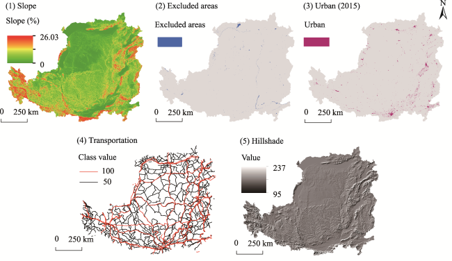
Fig. 2 Driving factors of the SLEUTH model on the Loess Plateau

Note: Excluded areas are generated from the distribution of nature reserves and water bodies, which cannot be converted to cities in the simulation iteration. 100 and 50 in the legend mean that the probability of conversion in these areas is high and low, respectively.

The SLEUTH model was then calibrated to obtain precise urban growth and available growth coefficients during the historical periods, and the best-fit set was selected from numerous combinations of parameter values based on 13 fitness statistics (Jantz et al., 2010; Zhou et al., 2019). Specifically, the model was used to calculate five coefficients by estimating four typical growth rules (i.e., spontaneous, new spreading center, edge, and road-influenced growth), including the diffusion factor (Diff), breed coefficient (Brd), spread coefficient (Sprd), slope resistance factor (Slp), and road gravity factor (RG) (e.g., Clarke and Gaydos, 1998; Liang and Liu, 2014). The urban growth extent was used to detect the classified maps from 1995-2015 as dependent variables. Land cover data from four periods (1995, 2000, 2005 and 2010) were introduced into the model at the calibration stage in order to explore its sensitivity to the local conditions as part of the optimization of the parameters.
The accuracy of the model was validated using the receiving operator characteristic (ROC) curve method. The area under the curve (AUC) was used to represent the ROC statistic, ranging from high to low probabilities (0.5-1). An AUC value of 0.5 means a random modeling result, while 1 means a perfect result for the model. The validation was conducted using SPSS 25.0 software. The LUCC map for 2010 was used as the input seed layer to predict the urban growth in 2015 during the validation. The datasets used here were independent from the calibration process and also from the parts of rapid urbanization that occurred in the study area. Thus, the consistency of the urban growth patterns can be examined for the calibration and validation stages during 1995-2015. After calibration and validation, the parameterized SLEUTH with spatial inputs (Fig. 2) was used to simulate the annual urban growth from 2015 to 2050.

2.4 Spatiotemporal characteristics of urban growth

The spatiotemporal characteristics of urban growth were calculated using two indicators. First, an urban growth rate for each city was calculated in every neighboring period from 1995 to 2050. Then, an urban growth type index was calculated to describe the changes in spatial patterns of the multi-level urban areas (Zhao et al., 2015). To detect the specific urban growth pattern at a given value of growth rate, the spatial mapping method was used to classify the types of urban growth into edge-growth, infilling and leapfrogging patterns to explain the various urban processes.
${{R}_{ug}}=\sqrt[t]{\frac{{{A}_{e}}}{{{A}_{s}}}}-1$
${{T}_{ug}}=\frac{{{L}_{c}}}{{{P}_{n}}}$
where Rug is the urban growth rate of each city, As and Ae are the urban areas at the initial and end years, respectively (km2), and t is the span of the study periods. Tug is the urban growth type index, Pn is the perimeter of a new urban patch (km), and Lc is the length of the common edge between the initial and the new urban patch (km). Zhao et al. (2015) demonstrated that patterns of urban growth can be detected according to the value of Tug: infilling (E>0.5), edge-growth (0<E≤0.5) and leapfrogging (E=0). The rate and type index of urban growth were computed using the Python 3.8 package.
We selected 15 typical urban areas from 346 multi-levels cities on the Loess Plateau to analyze their rates and spatial patterns (Table 1), using a hierarchal division of population-based criteria from the Chinese government (http://www.gov.cn/zhengce/). These urban areas were divided into a hierarchy of three types: Ⅰ (>10 million), Ⅱ (5-10 million) and Ⅲ (1-5 million). According to the census data for 2020 (Table 1), the population and gross domestic product (GDP) in the 15 selected urban areas accounted for 5% and 7% of the study area totals, respectively, indicating that these urban areas are significantly representative of the spatiotemporal characteristics of urban growth in the Loess Plateau. The research framework was divided into four steps for achieving the designated goals in this study (Fig. 3).
Table 1 Hierarchical division of 15 selected urban areas on the Loess Plateau
City Population (104 person) Area (km2) GDP (109 yuan) Government level (number of districts) Hierarchy level
Xi’an 1295.00 5146 1002.04 Provincial capital (11)
Taiyuan 530.41 1416 415.33 Provincial capital (6)
Lanzhou 435.94 1048 288.67 Provincial capital (5)
Hohhot 344.61 2065 280.07 Provincial capital (4)
Yinchuan 285.91 2311 196.44 Provincial capital (3)
Baotou 270.94 2546 278.74 Prefectural (6)
Luoyang 255.05 482 512.84 Prefectural (7)
Xining 246.80 487 137.3 Provincial capital (5)
Datong 203.02 3553 137 Prefectural (4)
Baoji 186.21 3577 227.7 Prefectural (4)
Changzhi 168.80 2585 171.16 Prefectural (4)
Xianyang 132.46 528 220.48 Prefectural (3)
Yulin 125.16 11096 408.97 Prefectural (2)
Tianshui 123.88 5894 66.69 Prefectural (2)
Weinan 118.86 2348 186.63 Prefectural (2)
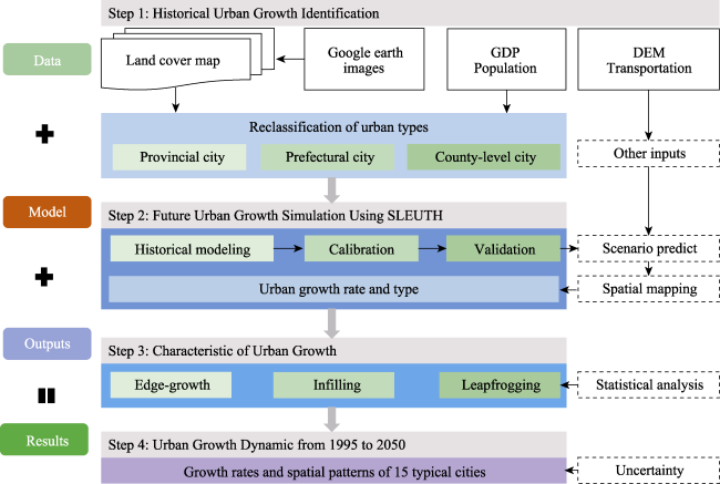
Fig. 3 The methodological framework used in this study

2.5 Data

Multi-source datasets were obtained to predict the urban dynamics on the Loess Plateau (Table 2). LULC maps were obtained from the ESA CCI data. A DEM and map of transportation were obtained from the Data Center for Resources and Environmental Sciences, Chinese Academy of Sciences (DCRES). Maps of city and administrative boundaries were obtained from National Geomatics Center of China (NGCC). The gross domestic product (GDP) and the seventh national population census data of each city in 2020 were obtained from the National Bureau of Statistics (NBS). All the map data were preprocessed and uniformly projected into a Krasovsky_1940_Albers projection with resampling at 1-km resolution in ArcGIS 10.2, which is a scale that is fine enough to reduce the computational time and reflect the detailed information of long-term regional land dynamics.
Table 2 Major input data for the integrated assessment model in this study
Data Source Type/resolution Years
LUCC maps ESA CCI, https://www.esa-landcover-cci.org Raster/300 m 1995-2015
DEM DCRES, http://www.resdc.cn/ Raster/30 m -
Transportation DCRES, http://www.resdc.cn/ Vector 1995-2015
City, boundary NGCC, http://www.ngcc.cn Vector 2015
GDP, population NBS, http://www.stats.gov.cn/ Text 2020

3 Results

3.1 Historical LUCC dynamics from 1995 to 2015

The spatial distribution and area percentages of LUCC dynamics were obtained on the Loess Plateau from 1995 to 2015 (Figs. 4 and 5). We found that the forest, grassland and farmland experienced drastic changes in the study area during the early period (1995-2005), and the degradation of grassland to unused land was observed in the northern part of the Loess Plateau. This was especially notable for Ordos City, where serious land degradation occurred, and the change of urban cover was not obvious in the study area. With the implementation of projects such as Grain for Green (2005‒2015), the area percentage of unused land decreased from 2.6% in 1995 to 1.59% in 2015, and farmland was further converted to forest and grassland while the spatial pattern of vegetation and farmland remained basically stable (Fig. 4), indicating that the policies associated with ecological restoration have played a practical role. Meanwhile, the urban growth in multiple regions began to increase rapidly, with an increasing trend in the area percentage from 0.3% in 1995 to 1.52% in 2015. Xi’an and Luoyang both showed significant increasing trends for urban growth, indicating that urban growth in the study area was influenced by a combination of policies, such as western development and regional urbanization, in the same period.
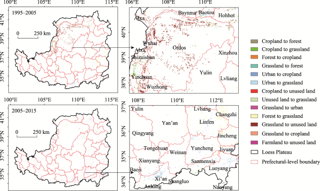
Fig. 4 Spatial patterns of land use on the Loess Plateau from 1995 to 2015
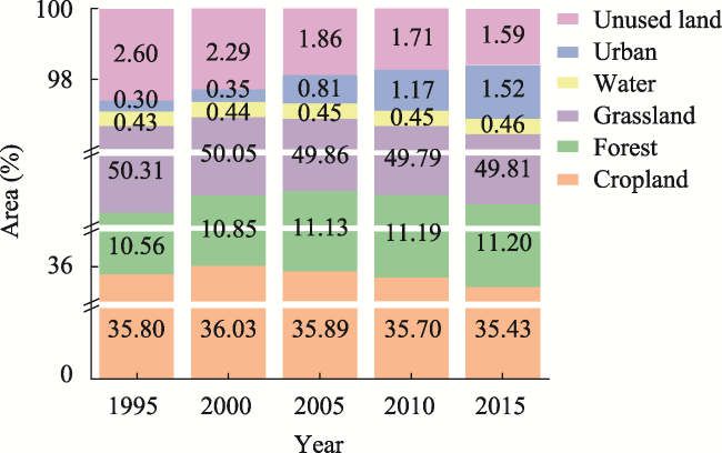
Fig. 5 Changes of the percentage values of land area on the Loess Plateau from 1995 to 2015

3.2 Scenario-based LUCC dynamics

3.2.1 Calibration and accuracy validation

A standard calibration process of the model was conducted using the input data from 1995-2010 (Table 3). Thirteen statistical metrics were computed using the model program to select the best coefficient values, and they indicate a good-fit performance of the model for the local characteristics in the historical period (Table 3). The Lee-Sallee index is a key indicator with a value of 0.6105, and it was used to combine the distributions of urban and nonurban patches according to the intersection over the union. The indicators of Compare (0.8953) and %urban (0.9972) show the similarity between the actual and simulated urban growth of the urban areas. The score of edges (0.6104) was used to indicate the correlation of urban edges between modeled and observed results. In general, the statistical metrics in this study were somewhat higher than their values in existing regional cases (e.g., Liang and Liu, 2014; Clarke and Johnson, 2020). The best combination of coefficients was (5, 30, 63, 49, 35) during the calibration, indicating that the outward spread pattern was a major characteristic of the study area.
Table 3 Calibration and validation of the SLEUTH model on the Loess Plateau
Product Compare Pop Edges Cluster Size Lee-Salee Slope %Urban Xmean Ymean
0.0383 0.8953 0.9972 0.6104 0.7814 0.7645 0.6105 0.8584 0.9972 0.7108 0.8523
Rad Fmatch Diff Brd Sprd Slp RG ROC AUC
0.9941 0.6064 5 30 63 49 35 0.8891 0.91

Note: Parameter data from Silva and Clarke, 2002. See the literature for details.

The spread outward pattern mainly occurred in several prefectural cities along the major transportation routes, which explains why the spread coefficient has the highest value in the calibration stage. The calibration of urbanization also was supported by the spatial changes in different stages as seen in the maps (Fig. 4). In addition, the urban growth also was dramatically influenced by the slope coefficient among the typical geographic characteristics of elevation and slope on the Loess Plateau. The diffusive growth pattern accounted for the lowest growth amount in the calibration stage, which is consistent with the rare observation of new urban areas in open spaces (Fig. 4). Finally, the simulated map for 2015 was obtained using the parameterized SLEUTH mentioned above. The ROC value (0.8891) was calculated using the maps of simulated and observed urban areas for 2015, showing that the simulated urban growth had high coherence with the observed results. The AUC value (P < 0.01) for urban growth was 0.91. The high accuracy of the validation indicated a good performance of SLEUTH at the urban level in this study area, which is consistent with the efficiency and accuracy of SLEUTH demonstrated in previous studies.

3.2.2 Simulation of SLEUTH

The parametrized SLEUTH model was then used to simulate the urban growth patterns (2015-2050) in the study area under the historical scenario, and that scenario reflected a continuation of urban growth from the actual historical trend without limitation (Fig. 6). The spatial patterns of the simulated maps showed that hot zones of urban growth occurred around the Tianshui-Guanzhong economic zone (i.e., Xi’an, Baoji and Xianyang) and the Yellow River belt with major provincial capitals (including Lanzhou, Yinchuan, Baotou, Taiyuan and Zhengzhou). Several middle and northern cities on the Loess Plateau (i.e., Hohhot and Yunlin) also showed a rapid urban growth trend in the future, however, the magnitudes of their spatial urban extents were lower than those in other hot zones. The temporal changes of urban growth under the historical scenario showed that the urban area expanded by 72.31% from 2015 (18384.55 km2) to 2050 (31678.01 km2), indicating that the high rate of urban growth will potentially cause the degradation of ecological and agricultural land in the plain areas of the Loess Plateau (Fig. 7a). In addition, the test of urban area anomalies showed that the year of 2035 would become an inflection point (Fig. 7b), and the urban area from 2035 to 2050 will show a trend of accelerating growth compared with the period of 2020-2035. This finding also can be used to formulate the medium- and long-term strategic planning for land development on the Loess Plateau (2035-2050). The results obtained with the historical scenario demonstrated a compact and continuous form of urban growth in the study area, facilitating the urban management and land use planning by local decision makers.
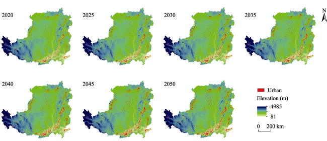
Fig. 6 Spatial changes in the urban areas on the Loess Plateau from 2020 to 2050
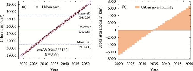
Fig. 7 Temporal change (a) and anomaly test (b) of urban areas on the Loess Plateau from 2020 to 2050

3.3 Rates and spatial patterns of urban growth

The 15 selected urban areas were used to analyze the rates of urban growth between specific neighboring periods from 1995 to 2050 on the Loess Plateau (Fig. 8). The average values of Rug for the 15 urban areas were 5.97% and 3.2% during the periods of 1995-2015 and 2015-2050, respectively. The temporal change of urban growth varied among the provincial capitals and prefectural cities over the study period. Of the provincial capitals, Xi’an and Hohhot increased by 1868 km2 and 627 km2 during the period of 1995-2050, respectively, so these cities accounted for 32.17% of the total increase in the urban area. It is also notable that Yinchuan shows a rapid urbanization with the highest annual increasing rate of 28.02% from 1995 to 2050. Changzhi and Datong increased by 694 km2 and 571 km2 from 1995 to 2050, which are the biggest increases among the prefectural cities. In addition, Weinan had a significant increase of 545 km2 under the influence of the rapid urbanization of the neighboring Xi’an-Xianyang urban agglomeration. The other ten cities contributed 44% of the increased urban area of the selected cities, although they had a high combined growth rate with an average annual value of 28.01%.
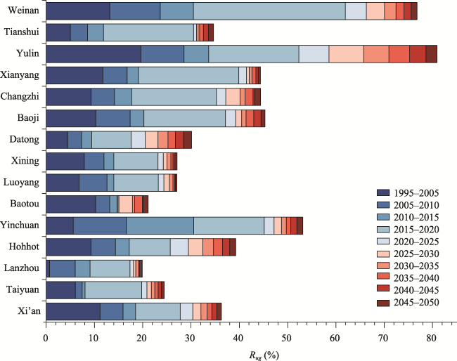
Fig. 8 The rates of urban growth for 15 typical cities between neighboring periods on the Loess Plateau from 1995 to 2050
Figure 9 shows the rapid urbanization of the 346 multi-levels cities which represent a combination of the three spatial patterns of urban growth. For the 15 selected cities, the areas and their relative proportions among the three types of urban growth have experienced drastic changes from 1995 to 2050 (Fig. 10). In the early period from 1995 to 2005, 87% of the cities exhibited the major spatial pattern of the leapfrogging urban growth type, and edge-growth showed a significantly increasing and dominating trend from 2005 to 2015. The rate of the spatial pattern of infilling also increased dramatically, especially during the period of 2010-2015, and its trend was the opposite of that for the area growth of the leapfrogging pattern. In the simulation period of 2015-2050, the leapfrogging pattern showed its peak in most cities (about 80%) from 2015 to 2020 because of the rapid urbanization policies (e.g., development of national new regions), which indicated that the results of this model can be used to identify the key urbanization processes in the study area. It is notable that the infilling pattern showed a sustained increasing trend (20%-50%) from 2030 to 2050, and the leapfrogging pattern showed a decreasing trend in the same period (less than 50% in the 15 cities). The edge-growth pattern showed an increasing trend from 1995 to 2050, although a higher average growth rate was observed in the simulation period (>50%) compared with the period of 1995-2015 (10%-50%). Changes in the urban growth patterns indicated that the path to addressing sustainable and intensive development will become the dominant issue thereafter, and the rapid urbanization of this region with the characteristics of large area expansion and land use change will come to the end in the period of the 2050s.
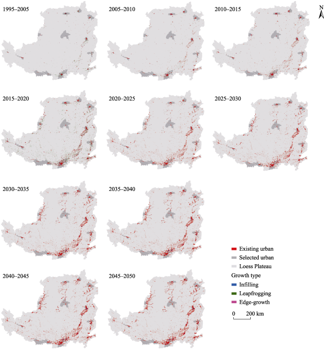
Fig. 9 Distributions of the three urban growth types on the Loess Plateau from 1995 to 2050
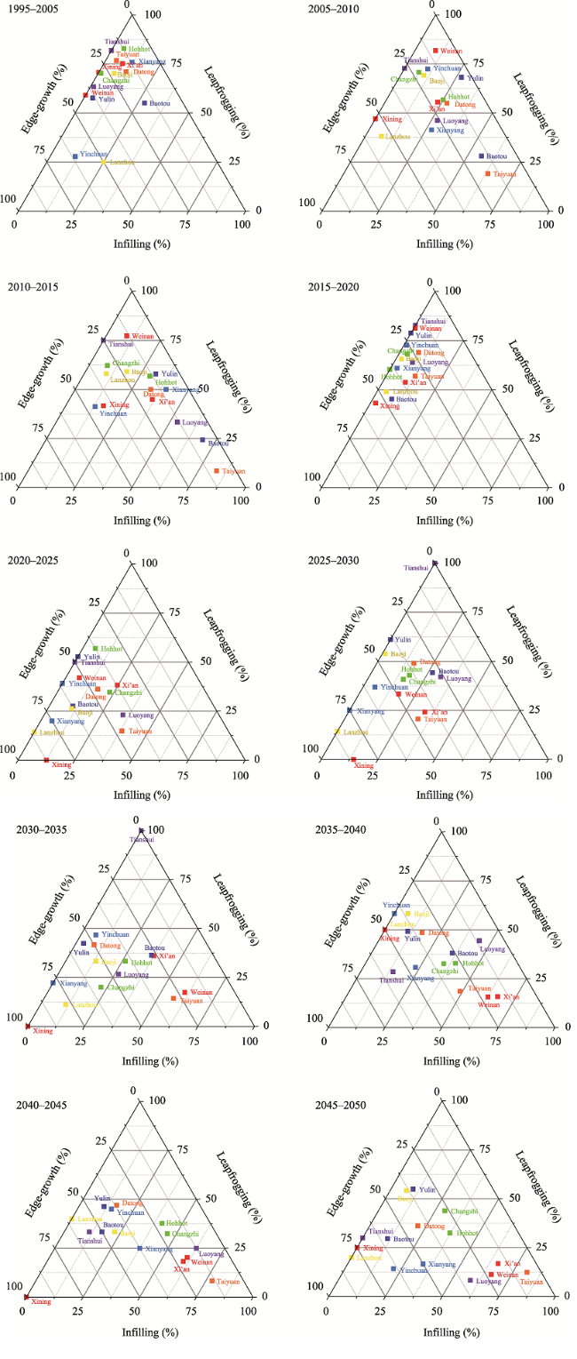
Fig. 10 Temporal changes in the proportional composition based on the areas of the three growth types for 15 typical cities from 1995 to 2050

4 Discussion

4.1 Usage of the urban growth dataset

The urban growth dataset produced with the SLEUTH model will support the analysis of future urbanization of the Loess Plateau by stakeholders based on historical processes from 1995 to 2015. In this study, various parameters of urban growth were obtained for predicting future multi-level urban expansion, and the impacts of urban growth under local scenarios should be study further regarding their importance in affecting the urbanization in this region, including socio-ecological policies, regional climate change and natural resources. The dataset of urban growth on the Loess Plateau (1995‒2050) has a resolution of 1 km×1 km, which is suitable for related investigations in the study area. According to the potential requirements of various projects, the spatial performance of the dataset can be modified based on the existing model and parameter settings, such as adjusting the excluded layer based on specific eco-policies in regions of interest.
The urban growth maps were generated as consistent annual products from SLEUTH, making the spatiotemporal changes in different urban expansions insignificant. We recommend that users can use 5- or 10-year products for different applications. The modeling method with SLEUTH and spatial mapping in this study could be improved by using inputs with higher resolution and more specific scenarios, especially for most of the model parameters (e.g., transportation), which can be renewed with timely data for updating the inputs from related data resources.

4.2 Urban growth diversity on the Loess Plateau

All the multi-level cities of the Loess Plateau experienced rapid urban growth. However, spatiotemporal variation in the growth patterns was observed among the cities. For the selected cities, the local managers should address the differences in the interurban growth patterns to improve their urban management measures in order to achieve the diverse urbanization development goals. Diverse rates and patterns of urban growth were identified by complex physical and development conditions in the local regions. For example, Yinchuan, Xining, and Lanzhou are in the ecological barrier regions of the Loess Plateau, so the fragile eco-environment restricts their urbanization process with a lower population and GDP compared with other provincial capitals (Table 1). Taking Lanzhou as an example, the step and platform topography of the loess has restricted its urban growth, and edge-expansion patches are only concentrated in the east-west direction of the valley area near the Yellow River and surrounded by northand south mountains. By comparison, the urban growth of plain cities showed high proportions of edge-expansion and leapfrogging patterns due to their advantage of flat and vast terrain (e.g., Xi’an and Changzhi). We recommend that local managers should promote mega-city development by implementing advanced intercity planning such as the rapid development of a Guanzhong-Tianshui economic zone (Figs. 6 and 9).

4.3 Uncertainties in the urban growth simulation

In this case study, we successfully developed an integrated modeling method by combining SLEUTH and spatial mapping for the Loess Plateau based on historical evidence from 1995-2050. The results of the calibration and validation showed the usefulness of SLEUTH for simulating urban growth based on a historical scenario. The scenario represented an actual growth strategy without socioeconomic restriction in the study area that could be useful to local managers. However, it should be noted that actual urban growth is a complex process affected by other factors related to land use change, socio-ecological policy, population and the environment. Further studies should be conducted to demonstrate the potential impact of urbanization as affected by diverse urban growth patterns using the high-resolution database of this study.
This study demonstrated that a standardized procedure of calibration and validation is useful for solving over-fitted problems in land use simulation (e.g., Liang and Liu. 2014), especially for the results of validation, which indicated the applicability of SLEUTH for producing precise maps of urban growth on the Loess Plateau. Furthermore, the sensitivity of the model parameters for different urban growth patterns was addressed in this study. For example, the parameters of dispersion and road growth were highly sensitive in the calibration process from 1995 to 2010. The Loess Plateau has been under dramatic pressure for socioeconomic development and ecological protection since the beginning of the late 1990s due to the rapid growth of urbanization and the population. According to the historical map for 1995- 2015, urban growth occurred at the expense of farmland, especially for the edge-growth and leapfrogging patterns. In addition, urban growth was particularly strong on the plains of Shaanxi and Shanxi, and also on both sides along the Yellow River and Weihe River.
Finally, we used the newest city boundaries to calculate urban growth based on the assumption that the extent of urban planning will not change in next 30 years, however, the expansion and incorporation of administrative boundaries is becoming an increasing trend in the study area (i.e., Xi’an). In this study, some developed prefectural cities could be underestimated where the extents of urban area are not correlated with the urban planning policy. To address the concerns of administrative boundaries in specific applications, we suggest modification of the spatial map with an external mask in GIS software in order to acquire reliable local information.

5 Conclusions

In this study, we produced an urban growth dataset from 1995 to 2050 with SLEUTH and standardized modeling procedures. Based on this dataset, we mapped the urban dynamics using the expansion rates and identification method of spatial growth patterns. Taking the 15 selected cities as an example, we found the growth rates and spatial patterns varied considerably among the multi-level cities due to their local physical environments, historical circumstances and regional policies. The overall urban growth rate from 1995 to 2015 was higher than the rate during the simulation period (2015-2050). Among spatial patterns, the edge-growth type accounts for a high proportion in most cities, except for the leapfrogging that dominated in the early period (1995-2015). The diverse growth patterns of urbanization indicated that the influences of driving factors (e.g., physical environment) on urban dynamics cannot be ignored in local urban management and development planning. It should be noted that the 346 multi-level urban areas on the Loess Plateau are believed to possess great potential for the future socioeconomic development of Western China.
For now, the urbanization of the region has lagged behind the average level of China, however, the recent policy of “High-quality development of the Yellow River Basin” will greatly promote the urbanization process on the Loess Plateau. The results obtained here with SLEUTH matched reality pretty well in the case study, indicating that the results are useful for identifying and comparing the typical urban growth patterns across multi-level cities. The application of the SLEUTH product and a spatial mapping method in this study could facilitate the implementation of urbanization policies and ecological conservation on the Loess Plateau.
[1]
Aburas M M, Ho Y M, Ramli M F, et al. 2016. The simulation and prediction of spatio-temporal urban growth trends using cellular automata models: A review. International Journal of Applied Earth Observation and Geoinformation, 52: 380-389.

[2]
Alberti M, Correa C, Marzluff J M, et al. 2017. Global urban signatures of phenotypic change in animal and plant populations. Proceedings of the National Academy of Sciences of the USA, 114(34): 8951-8956.

[3]
Chen Y P, Wang K B, Lin Y S, et al. 2015. Balancing green and grain trade. Nature Geoscience, 8(10): 739-741.

[4]
Clarke K C, Gaydos L J. 1998. Loose-coupling a cellular automaton model and GIS: Long-term urban growth prediction for San Francisco and Washington/Baltimore. International Journal of Geographical Information Science, 12(7): 699-714.

[5]
Clarke K C, Johnson J M. 2020. Calibrating SLEUTH with big data: Projecting California’s land use to 2100. Computers, Environment and Urban Systems, 83: 101525. DOI: 10.1016/j.compenvurbsys.2020.101525.

[6]
Cumming G S, Buerkert A, Hoffmann E M, et al. 2014. Implications of agricultural transitions and urbanization for ecosystem services. Nature, 515(7525): 50-57.

[7]
Curtis P G, Slay C M, Harris N L, et al. 2018. Classifying drivers of global forest loss. Science, 361(6407): 1108-1111.

[8]
DeFries R S, Rudel T, Uriarte M, et al. 2010. Deforestation driven by urban population growth and agricultural trade in the twenty-first century. Nature Geoscience, 3(3): 178-181.

[9]
Deng Y, Fu B J, Sun C Z. 2018. Effects of urban planning in guiding urban growth: Evidence from Shenzhen, China. Cities, 83: 118-128.

[10]
Díaz S, Demissew S, Carabias J, et al. 2015. The IPBES conceptual framework—Connecting nature and people. Current Opinion in Environmental Sustainability, 14: 1-16.

[11]
Ding C R, Li Z. 2019. Size and urban growth of Chinese cities during the era of transformation toward a market economy. Environment and Planning B: Urban Analytics and City Science, 46(1): 27-46.

[12]
Eeckhout J. 2004. Gibrat’s law for (all) cities. American Economic Review, 94(5): 1429-1451.

[13]
ESA European Space Agency. 2017. Land cover CCI product user guide version 2. Available at:maps.elie.ucl.ac.be/CCI/viewer/download/ESACCI-LC-Ph2-PUGv2_2.0.pdf.

[14]
Fang L, Li P, Song S. 2017. China’s urban development policies and city growth dynamics: An analysis based on the Gibran’s Law. International Review of Economics & Finance, 52: 322-329.

[15]
Feng X, Fu B, Lu N, et al. 2013. How ecological restoration alters ecosystem services: An analysis of carbon sequestration in China’s Loess Plateau. Scientific Reports, 3: 2846. DOI: 10.1038/srep02846.

[16]
GLP Global Land Project. 2005. Science plan and implementation strategy. IGBP Report no. 53/IHDP Report no. 19. Stockholm, Sweden: IGBP Secretariat.

[17]
Gong P, Wang J, Yu L, et al. 2013. Finer resolution observation and monitoring of global land cover: First mapping results with Landsat TM and ETM+ data. International Journal of Remote Sensing, 34(7): 2607-2654.

[18]
Grekousis G, Mountrakis G, Kavouras M. 2015. An overview of 21 global and 43 regional land-cover mapping products. International Journal of Remote Sensing, 36(21): 5309-5335.

[19]
Guzman L A, Escobar F, Pea J, et al. 2020. A cellular automata-based land-use model as an integrated spatial decision support system for urban planning in developing cities: The case of the Bogotá region. Land Use Policy, 92: 104445. DOI: 10.1016/j.landurbplan.2013.01.003.

[20]
Hartley A J, MacBean N, Georgievski G, et al. 2017. Uncertainty in plant functional type distributions and its impact on land surface models. Remote Sensing of Environment, 203: 71-89.

[21]
Jantz C J, Goetz S J, Donato D, et al. 2010. Designing and implementing a regional urban modeling system using the SLEUTH cellular urban model. Computers, Environment and Urban Systems, 34(1): 1-16.

[22]
Ke X L, van Vliet J, Zhou T, et al. 2018. Direct and indirect loss of natural habitat due to built-up area expansion: A model-based analysis for the city of Wuhan, China. Land Use Policy, 74: 231-239.

[23]
Kuang W H, Liu J Y, Dong J W, et al. 2016. The rapid and massive urban and industrial land expansions in China between 1990 and 2010: A CLUD-based analysis of their trajectories, patterns, and drivers. Landscape and Urban Planning, 145: 21-33.

[24]
Lambin E F, Meyfroidt P. 2011. Global land-use change, economic globalization, and the looming land scarcity. Proceedings of the National Academy of Sciences of the USA, 108(9): 3465-3472.

[25]
Lauer A, Eyring V, Righi M, et al. 2017. Benchmarking CMIP5 models with a subset of ESA CCI Phase 2 data using the ESMValTool. Remote Sensing of Environment, 203: 9-39.

[26]
Lawler J J, Lewis D J, Nelson E, et al. 2014. Projected land-use change impacts on ecosystem services in the United States. Proceedings of the National Academy of Sciences of the USA, 111(20): 7492-7497.

[27]
Li W, MacBean N, Ciais P, et al. 2018. Gross and net land cover changes in the main plant functional types derived from the annual ESA CCI land cover maps (1992-2015). Earth System Science Data, 10(1): 219-234.

[28]
Liang Y J, Liu L J. 2014. Modeling urban growth in the middle basin of the Heihe River, northwest China. Landscape Ecology, 29(10): 1725-1739.

[29]
Liu F, Yan H, Gu F X, et al. 2017. Net primary productivity increased on the Loess Plateau following implementation of the grain for green program. Journal of Resources and Ecology, 8(4): 413-421.

[30]
Liu L J, Wen Y Q, Liang Y J, et al. 2019. Extreme weather impacts on inland waterways transport of Yangtze River. Atmosphere, 10(3): 133. DOI: 10.3390/atmos10030133.

[31]
Qiu Z W, Monserrat O, Crosetto M, et al. 2021. An innovative extraction methodology of active deformation areas based on sentinel-1 SAR dataset: The Catalonia case study. International Journal of Remote Sensing, 42(16): 6228-6244.

[32]
Schneider A, Friedl M A, Potere D. 2010. Mapping global urban areas using MODIS 500-m data: New methods and datasets based on ‘urban ecoregions’. Remote Sensing of Environment, 114(8): 1733-1746.

[33]
Silva E A, Clarke K C. 2002. Calibration of the SLEUTH urban growth model for Lisbon and Porto, Portugal. Computers, Environment and Urban Systems, 26(6): 525-552.

[34]
Song W, Deng X. 2017. Land-use/land-cover change and ecosystem service provision in China. Science of the Total Environment, 576: 705-719.

[35]
Su C H, Fu B J. 2013. Evolution of ecosystem services in the Chinese Loess Plateau under climatic and land use changes. Global and Planetary Change, 101: 119-128.

[36]
Sun X, Wu J G, Tang H J, et al. 2022. An urban hierarchy-based approach integrating ecosystem services into multiscale sustainable land use planning: The case of China. Resources, Conservation and Recycling, 178: 106097. DOI: 10.1016/j.resconrec.2021.106097.

[37]
van Vliet J, Eitelberg D A, Verburg P H. 2017. A global analysis of land take in cropland areas and production displacement from urbanization. Global Environmental Change, 43: 107-115.

[38]
Wang S, Meng X, Chen G, et al. 2017. Effects of vegetation on debris flow mitigation: A case study from Gansu Province, China. Geomorphology, 282: 64-73.

[39]
Wu W J, Zhao S Q, Zhu C, et al. 2015. A comparative study of urban expansion in Beijing, Tianjin and Shijiazhuang over the past three decades. Landscape and Urban Planning, 134: 93-106.

[40]
Zhao S Q, Zhou D C, Zhu C, et al. 2015. Rates and patterns of urban expansion in China’s 32 major cities over the past three decades. Landscape Ecology, 30(8): 1541-1559.

[41]
Zhou Y, Varquez A C G, Kanda M. 2019. High-resolution global urban growth projection based on multiple applications of the SLEUTH urban growth model. Scientific Data, 6: 34. DOI: 10.1038/s41597-019-0048-z.

[42]
Zhou Y Y, Li X C, Asrar G R, et al. 2018. A global record of annual urban dynamics (1992-2013) from nighttime lights. Remote Sensing of Environment, 219: 206-220.

Outlines

/