Ecosystem Services and Sustainable Development

Variation of Water Conservation Function and Its Influencing Factors of Alpine Grasslands in Northern Tibet from 2000 to 2020

  • SONG Qian , 1, 2 ,
  • HE Yongtao , 2, 3, * ,
  • HUANG Fengrong , 1, * ,
  • LI Meng 4
Expand
  • 1. Liaoning Normal University, Dalian, Liaoning 116029, China
  • 2. Lhasa Plateau Ecosystem Research Station, Key Laboratory of Ecosystem Network Observation and Modeling, Institute of Geographic Sciences and Natural Resources Research, Chinese Academy of Sciences, Beijing 100101, China
  • 3. College of Resources and Environment, University of Chinese Academy of Sciences, Beijing 100190, China
  • 4. School of Geographic Sciences, Nantong University, Nantong, Jiangsu 226007, China
*HE Yongtao, E-mail: ;
HUANG Fengrong, E-mail:

SONG Qian, E-mail:

Received date: 2022-10-20

  Accepted date: 2022-11-30

  Online published: 2023-04-21

Supported by

The Strategic Priority Research Program of the Chinese Academy of Sciences(XDA19050502)

The Second Tibetan Plateau Scientific Expedition and Research (STEP) Program(2019QZKK1006)

Abstract

With an average elevation of more than 4500 m, northern Tibet, known as the “roof of the world roof”, serves as the main body of the Qinghai-Tibetan Plateau’s ecological security barrier. However, the alpine grassland ecosystem in northern Tibet has suffered considerable alterations as a result of both climate change and overgrazing, and there is a degradation trend in some regions. In 2009, one ecological engineering, the Protection and Construction Project of Ecological Security Barrier in Tibet (hereafter referred to as the “Project”) was implemented to preserve the alpine ecosystem and restore service functions in the plateau. Water conservation is one of the most important service functions in alpine grassland ecosystem in northern Tibet, where is one part of the Asian Water Tower. To clarify the specific ecological benefits of the Project, this paper utilized the InVEST model to evaluate the variation trend of the water conservation function of alpine grasslands in northern Tibet before and after the implementation of the Project from 2000 to 2020, and contribution rate of climate change and the Project was also quantified. Results showed that: (1) Although the water conservation capacity of different grassland types in northern Tibet were varied, their water conservation function all altered dramatically after implementation of the Project. Specifically, the water yield has increased by 10.07%, and the water source supply service has increased by 8.86%. Among these grasslands, the alpine meadow had the highest increasing rate, water conservation capacity increased from -1.84 mm yr-1 to 2.24 mm yr-1 Followed by the alpine desert steppe and the alpine steppe, the rate of water conservation function were decreased significantly due to the Project. (2) Although climate is still the primary factor affecting the water conservation function of alpine grasslands in northern Tibet, the Project has effectively promoted the local water conservation function, with contribution rates of 13.99%, 8.75%, and 3.71% in the alpine meadow, alpine steppe and alpine desert steppe regions respectively.

Cite this article

SONG Qian , HE Yongtao , HUANG Fengrong , LI Meng . Variation of Water Conservation Function and Its Influencing Factors of Alpine Grasslands in Northern Tibet from 2000 to 2020[J]. Journal of Resources and Ecology, 2023 , 14(3) : 493 -501 . DOI: 10.5814/j.issn.1674-764x.2023.03.006

1 Introduction

With a total area of 59.5×10⁴ km², northern Tibet (29°53′- 36°32′N, 78°41′-92°16′E) is situated in the hinterland of the Qinghai-Tibetan Plateau, north of the Kailash Range and the Nyainqentanglha Range and to the south of the Karakoram Range. It is known as the “roof of the world roof”, with an elevation of 4500-5300 m. Due to the plateau topography, northern Tibet is particularly sensitive to climate change. In addition to being a significant river source area for China and Southeast Asian countries, it is the headwaters of numerous rivers, including the Nujiang River, the Lhasa River, the Shiquan River, and the Indus River of its lower reaches. It is also a significant part of the Asian Water Tower, where have more than 3000 plateau lakes, including Selinco and Namco. As the planning area of the environmental protection and restoration project of river source areas, northern Tibet is a key part of the ecological security barrier on the Qinghai-Tibetan Plateau (Liu, 2012), and its water storage capacity plays an essential role in the regional water resource circulation and climate regulation.
Water conservation, as one of the crucial ecological service functions, participates in numerous crucial ecological processes, affecting nutrient cycling, productivity, and other ecosystem functions (Zuo et al., 2022). Moreover, water conservation continues to impact the regional ecological environment, with a contribution rate of 28.95% to the value of grassland ecological service function (Liu et al., 2021), higher than other service such as carbon sequestration and soil preservation (Yu et al., 2017). Therefore, the water conservation function variation of alpine grassland has been a hot spot of scientific research, as it is situated in the core ecological security barrier of the Qinghai-Tibetan Plateau (Xiao et al., 2015; Gong et al., 2017).
Shao et al. (2017) have evaluated the ecological effectiveness of the Three-River Source region ecological protection project in terms of ecosystem services and determined their influencing factors. Results showed that after implementation of the project, water conservation and water supply services in the basin were improved, the degraded grassland in the protected area was significantly improved, and the contribution rate of ecological engineering to the increasing of forest and grass ecosystem services reached 24%. Huang et al. (2015) also evaluated the changes of ecosystem services in key ecological functional areas in China, and concluded that the implementation of ecological engineering had played a positive role in improving the water conservation services of alpine grassland. Other researchers also found that grassland degradation was the main reasons for the decrease of water supply (Pan et al., 2013; Xu et al., 2013). On the other hand, under the climate change on the Qinghai-Tibetan Plateau, the local hydrothermal environment jointly affects the spatial pattern of water conservation (Gong et al., 2017; Wang et al., 2022), and water conservation was most sensitive to soil water content (Lan et al., 2021), increasing of precipitation more than that of evapotranspiration was the direct reason for the increasing of water conservation (Yin et al., 2013).
However, the alpine grassland ecosystems in northern Tibet are quite fragile due to their geographical conditions of high elevation, cold, and dry climate. The alpine grassland in northern Tibet has undergone different degrees of degradation as a result of climate change and overgrazing, and the total degradation has accounted for half of the natural grasslands (Wang et al., 2013; Zhang et al., 2015; Piao et al., 2019). To restore the plateau’s ecological service function, one ecological engineering, the Protection and Construction Project of Ecological Security Barrier in Tibet (hereafter referred to as the “Project”) was implemented by Chinese government in 2009 (Wang et al., 2017a). With the implementation of ecological engineering, more and more scholars paid attention to the ecological effects of ecological protection and construction projects in Tibet (Huang et al., 2018), but there are few studies on the variation of water conservation function in northern Tibet and the assessment of the ecological engineering effects.
Therefore, to assess the water conservation function of the alpine grassland ecosystem in northern Tibet and the Project’s ecological effect, this research base on the InVEST model to compare the water conservation function before (2000-2008) and after the Project (2009-2020), and quantified the contribution rate of ecological engineering using regression analysis and residual methods. Additionally, this research attempts to reveal the driving factors based on correlation analysis and investigate their regulation mechanism of climate factors and engineering factors, thus providing scientific support for assessing the ecological engineering effects and constructing the ecological security barrier on the Qinghai-Tibetan Plateau (Zhong et al., 2006).

2 Materials and methods

2.1 Study area

The climate in north Tibet was typical plateau monsoon climate. The temperature in northern Tibet exhibits a gradient decline from south to north, annual average temperature in most places is below 0 ℃, and the average temperature of the warmest month is less than 14 ℃ (Yang et al., 2003); the annual average precipitation is between 50mm and 700 mm, with the gradient decreasing gradient from southeast to northwest (Zhao et al., 2020). Most places in this region have annual sunshine hours more than 2500 h, the annual average wind speed is larger than 4 m s-1, thus the annual evaporation is greater than 1800 mm, and the annual average aridity index (AI) is between 1.6 and 20.0 (Mao et al., 2006).
In northern Tibet, the natural grasslands account for 80% of the entire land area, with alpine meadow (AM), alpine steppe (AS) and alpine desert steppe (ADS) distributed from east to west due to differences in hydrothermal conditions (Fig. 1). About 15.90% of the total natural grassland alpine meadow, where annual average precipitation is over 400 mm, plant community primarily composited by Kobresia and Carex of the Cyperaceae family, which is a typical low mat-forming grass featuring higher gazing tolerance perennials. About 68.00% of the total natural grasslands is alpine steppe, where the annual precipitation is between 200 mm and 350 mm. The plant community composition of the alpine steppe is simple, with the dominant species of xerophytic grasses or subshrubs, with relatively low forbs yield. About 10.26% of the natural grasslands is alpine desert steppe, where the annual precipitation is between 50 mm and 200 mm. The plants of the alpine desert steppe are low and sparse, which is dominated by clumps of short grasses mixed with dwarf and subshrubs.
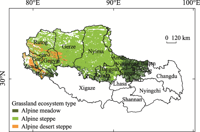
Fig. 1 Distribution of grassland ecosystems in northern Tibet

2.2 Methods

The water conservation capacity of the grassland ecosystems in northern Tibet was assessed in this study based on the InVEST model by calculating the ecosystem’s water-holding capacity through the water balance equation (Huang et al., 2013; Zuo et al., 2022). The InVEST model has been extensively utilized in researches on the water conservation function of alpine grasslands on the Qinghai-Tibetan Plateau (Pan et al., 2013; Qiao et al., 2018).

2.2.1 Calculation of water conservation

Water conservation is calculated by water yield, and the specific calculation method is as follows (Lu et al., 2020):
$WR=\text{min}\left( 1,\frac{249}{V} \right)\times \text{min}\left( 1,\frac{0.9\times TL}{3} \right)\times \text{min}\left( 1,\frac{{{K}_{\text{sat}}}}{300} \right)\times Y(x)$
where WR represents the water conservation/retention per unit area; V represents refer to the flow velocity coefficient; TL refer to the topographic index;Ksat refer to the soil saturated water conductivity; Y(x) represents the water yield of grid x(mm).
Water yield can be obtained through following water balance equation:
$Y(x)=\left( 1-\frac{AET(x)}{P(x)} \right)\times P(x)$
where AET(x) represents the actual evapotranspiration on annually scale of the pixel (mm); P(x) represents the annual precipitation of the pixel (mm).
For land use/cover types with vegetation, the calculation formula of evapotranspiration is as follows:
$\frac{AET(x)}{P(x)}\text{=1+}\frac{PET(x)}{P(x)}-{{\left[ \text{1+}{{\left( \frac{PET(x)}{P(x)} \right)}^{\omega }} \right]}^{1/ \omega }}$
where PET(x) refers to the potential evapotranspiration; ω refers to the empirical parameters of soil properties.

2.2.2 Residual analysis

The residual method was be used for quantitative discrimination between human and natural factors in grassland ecosystems (Yan et al., 2022), typically applied to those in arid and semi-arid areas where ecological indicators are significantly related to the annual climate factors. This research established a pixel scale regression model of water conservation and climate factors to separate the spatial distribution of the driving forces, and the formulas are as follows:
$W{{R}_{\text{pre}}}=a\times {{T}_{\text{mean}}}+b\times {{P}_{\text{total}}}+c$
$W{{R}_{\text{res}}}=W{{R}_{\text{obs}}}-W{{R}_{\text{pre}}}$
where ${{T}_{\text{mean}}}\text{ }\!\!~\!\!\text{ and}\ {{P}_{\text{total}}}$ refer to the annual average temperature and cumulative rainfall, respectively; $a,\ b,\ \text{and}\ c$ are model parameters; $W{{R}_{\text{obs}}}$, $W{{R}_{\text{pre}}}$, and $W{{R}_{\text{res}}}$ refer to the observed value (simulated value), predicted value (impact of climate factor), and residual value (impact of human activity) of water conservation, respectively.

2.2.3 Contribution rate of ecological engineering and climate change

The contribution rate of ecological engineering and climate change to water conservation function change is a secondary indicator for evaluating the ecological effects of ecological protection and construction projects, which was used for comparing changes before and after the project implementation under average and actual climate conditions (Shao et al., 2016). The formulas are as follows:
${{C}_{\text{nature}}}=\frac{{{G}_{AI}}-{{G}_{AP}}}{\left| {{G}_{RI}}-{{G}_{RP}} \right|}$
${{C}_{\text{project}}}=\frac{{{G}_{EI}}-{{G}_{EP}}}{\left| {{G}_{RI}}-{{G}_{RP}} \right|}–{{C}_{\text{nature}}}$
where ${{C}_{\text{project}}}$ is the contribution rate of ecological engineering; ${{C}_{\text{nature}}}$ is the contribution rate of natural factors (mainly climate change); ${{G}_{AI}}$, ${{G}_{AP}}$ refer to the indices before and after the project implementation under the average climate conditions, and ${{G}_{RI}}$, ${{G}_{RP}}$ refer to the indices under actual climate conditions; $~{{G}_{EI}}$ and ${{G}_{EP}}$ refer to the residual levels.

2.3 Data

(1) Annual precipitation: daily scale precipitation interpolation of national stations with a resolution of 1 km downloaded from the National Meteorological Science Data Center (http://data.cma.cn). Potential evapotranspiration (PET): the annual data set MOD16A3 with a resolution of 500 m based on the PM model provided by NASA EARTH DATA.
(2) Root-restricting layer depth: replaced by the depth from soil grid to bedrock (layer R), obtained with the ISRIC Soil Terrain Digital Database (SOTER) from the National Earth System Science Data Center (http://www.geodata.cn/). Plant available water capacity (PAWC): obtained from the global data set “Soil Grids 250 m 2017-03 Available Soil Water Capacity” provided by ISRIC. The weighted average of 7 standard depths was calculated, with the weight based on the depth of each layer relative to the total depth.
(3) Land use/land cover (LULC): obtained from the seven phases of 2000, 2005, 2010, 2013, 2015, 2018, and 2020 interpreted by Landsat with a scale of 1: 1000000, which is downloaded from the Resource and Environment Science and Data Center of the Chinese Academy of Sciences (http://www.resdc.cn/). River network basin data is obtained from the same source, and the basin vector boundary should correspond to the terrain. DEM is assembled based on the data downloaded from the Geospatial Data Cloud.
(4) Biophysical parameters: the land type code should be consistent with the LULC attribute table. Root_depth (vegetation root depth) is obtained from the soil depth in the HWSD soil database; Kc (evapotranspiration coefficient) should be a decimal between 0 and 1.5; LULC_veg (coefficient of land use type) is 1 for vegetation type and 0 for non-vegetation type. Zhang coefficient: Better effect when Z is 22.7 as a result of comparing and matching the simulated and observed values of multiple water yields according to the definition of seasonal precipitation distribution.

3 Results

3.1 Spatial pattern of water conservation function

Compared with other regions in China, northern Tibet’s water conservation capacity is still low due to its high elevation, low rainfall and sparse of grasslands. The average water conservation in northern Tibet from 2000 to 2020 was 121.86 mm, with a minimum and maximum of 65.11 mm and 173.50 mm in 2015 and 2018, respectively. The average water conservation per unit area was 103.54 mm km-2, and the average annual total water conservation was 6.59× 10⁷ m3 yr-1. Overall, the water conservation decreased from humid area in the east to arid area in the southwest (Fig. 2), and the low-value areas were concentrated in the western alpine steppe and desert steppe regions, with the water yield generally less than 30 mm yr-1, indicating a lower water conservation capacity. However, in the southeast alpine meadow areas, such as Lhari, Biru, and Baqen counties, with higher vegetation coverage and higher precipitation, the water conservation was more than 210 mm yr-1. As to different types of alpine grassland, the alpine meadow has the highest water conservation per unit area, with a multi-year average of 237.27 mm km-2; the alpine steppe has the highest total conservation of 4.32×10⁷ m3 yr-1 due to their large areas, accounting for 63.58% of the total; the alpine desert steppe has the lowest total conservation of 0.09 mm km-2 and the lowest proportion of 1.26%.
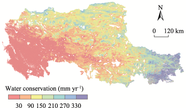
Fig. 2 Spatial distribution of water conservation in northern Tibet

3.2 Trend of water conservation function

The water conservation function was compared between two periods before and after the Project implementation in 2009, results showed there had significant differences in the changing trend of water conservation capacity. Before the Project (2000-2008), grasslands with decreasing water conservation function accounted for 57.51% of the northern Tibet, and grasslands with obviously increasing function accounted for only 1.20%, primarily the alpine steppe at the center of Nyima County (Fig. 3a). As to different types of alpine grassland, 14.42% of alpine meadow and alpine desert steppe showed obviously decreased trend, and 10.83% of the alpine steppe showed a slow declining trend in the water conservation function. In contrast, water conservation exhibited a clearly increasing trend after the implementation of the Project (2009-2020). In addition to the areas with lightly increasing trend, areas with obviously increased functions accounted for 21.44% of the northern Tibet, mainly distributed at the Nyima, Bangoin, and Amdo counties. The proportion of areas with an obviously decreasing trend was 11.39%, which mainly distributed in the north of Gerze country, and the southern areas of Lhari, Biru County (Fig. 3b).
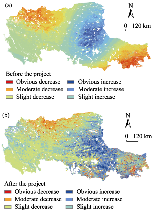
Fig. 3 Trend of water conservation before and after the Project in northern Tibet
Take the ratio of water yield to precipitation as an index of water source supply service (WSS service), the average value of overall WSS service in northern Tibet from 2000 to 2020 was 37.05%, indicated that grasslands stored more than a third of the natural precipitation for water source regulation (Fig. 4). The WSS service in northern Tibet had an obvious decreasing trend before the implementation of the Project, but it rose by 8.86% and had a constant increasing trend after the Project, and water yield has increased by 10.07% (Fig. 4). The WSS service had a peak at 45.54% in year 2014 and a lowest value at 24.57% in 2015 as a result of the drought. Moreover, variations of WSS service and water conservation before the Project were essentially synchronized, indicated that regional precipitation was highly correlated with the water conservation function. After implementation of the Project in 2009, the variation trend of water yield and WSS service became different, but the WSS service remained at a high level even when the water yield was low.
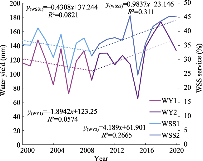
Fig. 4 Water yield and WSS services in northern Tibet during 2000-2020
According to the variation rates of the water conservation functions in different types of grasslands, after implementation of the Project, the decline rate of the alpine desert steppe slowed down, and alpine meadow even changed from decline to increase (Table 1), indicated that the water conservation function has been significantly improved due to the Project. Specifically, the alpine meadow (AM) had the highest increase rate from -1.84 mm yr-1 to 2.24 mm yr-1 after the Project; followed by the alpine desert steppe (ADS), increasing from -1.25 mm yr-1 to -0.39 mm yr-1; The water conservation of the alpine steppe (AS) slightly increased from -0.81 mm yr-1 to -0.03 mm yr-1. Implementation of the Project slowed down or even reversed the decreasing trend of water conservation in the southeast and northwest areas of northern Tibet, which indicated that ecological engineering can mitigate the effects of climate change on water conservation.
Table 1 Water conservation capacity of different kinds of alpine grasslands in northern Tibet
Period Grassland type Water conservation per unit area
(mm km-2)
Total water
conservation
(107 m3 yr-1)
Water
conservation
ratio (%)
Rate of change
(mm yr-1)
2000-2008 AM 128.93 1.30 35.38 -1.84
AS 59.11 2.30 62.77 -0.81
ADS 19.15 0.06 1.86 -1.25
2009-2020 AM 123.39 1.24 31.77 2.24
AS 66.56 2.59 66.32 -0.03
ADS 21.03 0.07 1.91 -0.39

3.3 Contribution rate of ecological engineering

The contribution rate of each factor was calculated in this study based on the residual method. Results demonstrated that climate change continued to have a significant role in regulating the water conservation variation in the alpine grassland after the Project, with ecological engineering alone having a relative lower contribution rate (Fig. 5a). Climate change accounted for 66.82%, 56.32% and 46.78% of the water conservation variation in the alpine steppe, alpine meadow and alpine desert steppe, respectively. However, the contribution rate of ecological engineering was gradually increasing, and the difference between the three types of grassland remained significant (Table 2). The alpine meadow was the mostly affected by ecological engineering with a contribution rate of 13.99%, followed by the alpine steppe (8.75%) and the alpine desert steppe (3.71%). From a spatial perspective, ecological engineering primarily enhanced and promoted the water conservation function in the eastern regions of northern Tibet but had no significant effect on the regions west to Nyima County (Fig. 5b). Above results demonstrated that ecological engineering had a greater impact on water conservation in the alpine meadow than it did in alpine steppe and alpine desert steppe.
Table 2 Contribution rate of dominant factors of in different types of grassland (Unit: %)
Contribution rate of the single factor AM AS ADS
Dominated by ecological engineering 13.99 8.75 3.71
Dominated by climate change 56.32 66.82 46.78
Others 29.69 24.43 49.51
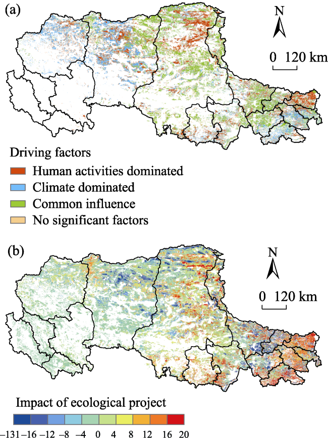
Fig. 5 Driving factors of water conservation (a) and impact of ecological engineering (b) in northern Tibet

Note: Value>0, Promote; Value<0, Restrain.

4 Discussion

4.1 Impact of climate factors

Results have showed that the local rainfall and temperature jointly affected the spatial pattern of ecosystem water conservation (Gong et al., 2017; Wang et al., 2022). In this study, more than half of variation in the water conservation function of alpine grassland in northern Tibet also was dominated by climate factors. In general, precipitation in northern Tibet decreased while temperature increased before the implementation of the Project (Fig. 6), causing the local environment to be drier, and the increase of evapotranspiration intensity was greater than that of precipitation, resulting in a decline in water conservation capacity (Lu et al., 2020; Zhao et al., 2020). Although the temperature in northern Tibet continued to rise slowly after the Project, an increase in rainfall offset the impact of the temperature rise (Du et al., 2008; Song et al., 2012; Yin et al., 2013; Shao et al., 2022). Warmer and wetter climates increased the NPP and NDVI of grasslands in northern Tibet (Ding et al., 2010; Wang et al., 2017b), which improved the water conservation function.
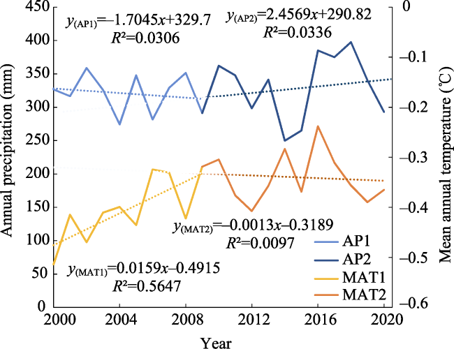
Fig. 6 Variation of annual precipitation and average annual temperature in northern Tibet between 2000 and 2020
In terms of the variation of climate factors in different types of alpine grassland in northern Tibet, compared with that before the Project, the average temperature in alpine meadow area increased by 0.07 ℃, but the accumulated rainfall decreased by 14.58 mm, thus lead to water conservation decreased by 5.55 mm km-2; the average temperature in the alpine steppe area decreased by 0.06 ℃, the accumulated rainfall increased by 3.03 mm, and the water conservation increased by 7.45 mm km-2; the average temperature in the alpine desert steppe area decreased by 0.26 ℃, the accumulated rainfall increased by 6.57 mm, and the water conservation level increased by 1.88 mm km-2.
According to the partial correlation analysis, the correlation between ecosystem water conservation and rainfall of all the three types of alpine grassland were higher than that of temperature. And in the alpine meadow and alpine steppe, the correlation of water conservation with rainfall was positive but with temperature was negative before the Project; however, after the Project, the correlation between water conservation and rainfall decreased and with temperature increased (Table 3). These correlation variations before and after the implementation of the Project reflected the impact of ecological engineering.
Table 3 Correlation between climate factors and water conservation
Climate factors Period Grassland type
AM AS ADS
Rainfall
(mm yr-1)
2000-2008 0.99 0.98 0.09
2009-2020 0.96 0.91 0.74
Temperature
(℃)
2000-2008 -0.20 -0.12 -0.28
2009-2020 0.58 -0.18 -0.13

4.2 Impact of ecological engineering

Northern Tibet is an essential natural pasture in Tibet (Li et al., 2021), and its herbage largely depends on natural grasslands, but overgrazing will lead to degradation of alpine grassland, especially the decline of grassland coverage directly led to the decreasing of water conservation function (Pan et al., 2013; Xu et al., 2013). One important measure of the Project was to decrease livestock grazing in north Tibet and even prohibit grazing in some areas. According to one research, the effective area of grazing prohibition reached 67.3% of the total area of in north Tibet and resulted in an increasing of NDVI (Feng et al., 2019). This indicated that the reduction of grazing pressure can effectively promote the vegetation restoration of alpine grassland, and thus the grassland ecosystem services were improved.
During this research period, the number of livestock in northern Tibet doubled in 2015 compared to 1958 (Hasbagan et al., 2019), as a result, half of the grasslands in northern Tibet had different degrees of degradation, which also had a severe negative impact on the ecological service function provided by the grasslands (Zhang et al., 2015; Piao et al., 2019). According to statistics, the number of livestock in northern Tibet decreased by 19.49% after the Project, declining from the peak of 1943.23×104 sheep unit to 1553.96×104 sheep unit in 2020 (Fig. 7). Decreasing of the forage-livestock conflict have improved the productivity and coverage of alpine grasslands in northern Tibet (Chen et al., 2014; Cao et al., 2020; Li et al., 2021). The overall degradation trend of alpine grassland has been effectively controlled under the implementation of ecological engineering, thus increased the soil moisture content (Wang et al., 2003) and enhanced the water conservation capacity of alpine grassland ecosystems (Lan et al., 2021). Other research also demonstrated that ecological engineering has effectively counteracted the negative effects of climate change and human activities on ecosystem services (Fu et al., 2012), becoming key driving force for environmental improvement.
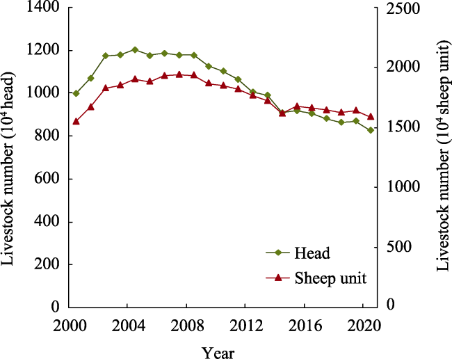
Fig. 7 Variation of livestock in northern Tibet between 2000 and 2020

5 Conclusions

This study assessed the water conservation function of alpine grassland in northern Tibet from 2000 to 2020. Based on the different types of grassland, the changing trend of water conservation function before and after implementing the Project were compared, and their driving factors were investigated. Results showed that since the implementation of the Project, water yield has increased by 10.07%, and the water source supply service has increased by 8.86% in north Tibet. Additionally, the decreasing trend of water conservation function in three types of alpine grassland were all changed after the Project, of which the alpine meadow experienced the fastest growth, rising from -1.84 mm yr-1 to 2.24 mm yr-1. Notably, Ecological engineering considerably enhanced the water conservation function in northern Tibet, but showed different contribution rate in various types of grassland, which the highest contribution rate in alpine meadows at 13.99%, followed by alpine steppe at 8.75% and alpine desert steppe at 3.71%, which indicated that the ecological effects of the project was gradually becoming obvious, different protective and construction planning should be implemented based on the alpine grassland types in further ecological engineering.
[1]
Cao Y N, Wu J S, Zhang X Z, et al. 2020. Comparison of methods for evaluating the forage-livestock balance of alpine grasslands on the Northern Tibetan Plateau. Journal of Resources and Ecology, 11(3): 272-282.

[2]
Chen B X, Zhang X Z, Tao J, et al. 2014. The impact of climate change and anthropogenic activities on alpine grassland over the Qinghai-Tibet Plateau. Agricultural and Forest Meteorology, 189: 11-18.

[3]
Ding M J, Zhang Y L, Liu L S, et al. 2010. Seasonal time lag response of NDVI to temperature and precipitation change and its spatial characteristics in Tibetan Plateau. Progress in Geography, 29(4): 507-512. (in Chinese)

[4]
Du J, Bian D, Bao J H, et al. 2008. Changes of pan evaporations and its impact factors over Northern Tibet in 1971-2006. Advances in Water Science, 19(6): 786-791. (in Chinese)

[5]
Feng Y F, Li M, Li S W, et al. 2019. Effectiveness of grazing exclusion on the restoration of degraded alpine grasslands on the Northern Tibetan Plateau from 2010 to 2017. Pratacultural Science, 36(4): 1148-1162. (in Chinese)

[6]
Fu B J, Lu Y H, Gao G Y. 2012. Major research progresses on the ecosystem service and ecological safety of main terrestrial ecosystems in China. Chinese Journal of Nature, 34(5): 261-272. (in Chinese)

[7]
Gong S S, Xiao Y, Zheng H, et al. 2017. Spatial patterns of ecosystem water conservation in China and its impact factors analysis. Acta Ecologica Sinica, 37(7): 2455-2462. (in Chinese)

[8]
Hasbagan G, Hu G Z, Gao Q Z, et al. 2019. Synergetic mode for grassland ecological management and animal husbandry development in Northern Tibet Plateau. Engineering Science, 21(5): 93-98. (in Chinese)

[9]
Huang C H, Yang J, Zhang W. 2013. Development of ecosystem services evaluation models: Research progress. Chinese Journal of Ecology, 32(12): 3360-3367.

[10]
Huang L, Cao W, Wu D. et al. 2015. Assessment on the changing conditions of ecosystems in key ecological function zones in China. The Journal of Applied Ecology, 26(9): 2758-2766. (in Chinese)

[11]
Huang L, Cao W, Xu X L, et al. 2018. The ecological effects of ecological security barrier protection and construction project in Tibet Plateau. Journal of Natural Resources, 33(3): 398-411. (in Chinese)

[12]
Lan X Y, Ye C C, Wang Y, et al. 2021. Spatiotemporal variation characteristics and its driving forces of water conservation function on the Tibetan. Acta Agrestia Sinica, 29(S1): 80-92. (in Chinese)

[13]
Li M, Yu H L, Meng B P, et al. 2021. Drought reduces the effectiveness of ecological projects: Perspectives from the inter-annual variability of vegetation index. Ecological Indicators, 130: 108158. DOI: 10.1016/j.ecolind.2021.108158.

[14]
Liu X Y. 2012. Current situation and development trend of the alpine rangeland ecosystem in Northern Tibet, China. Pratacultural Science, 29(9): 1352-1358. (in Chinese)

[15]
Liu Y Y, Ren H Y, Zhou R L, et al. 2021. Estimation and dynamic analysis of the service value of grassland ecosystem in China. Acta Agrestia Sinica, 29(7): 1522-1532. (in Chinese)

[16]
Lu L T, Ren T T, Sun C Z, et al. 2020. Spatial and temporal changes of water supply and water conservation function in Sanjiangyuan National Park from 1980 to 2016. Acta Ecologica Sinica, 40(3): 993-1003. (in Chinese)

[17]
Mao F, Lu Z G, Zheng L Y, et al. 2006. Variation characteristics of sunshine duration and wind velocity in Naqu, Xizang for recent 40 years. Meteorological Monthly, 32(9): 77-83. (in Chinese)

[18]
Nie Y H, Gong B, Li Z. 2010. The spatial-temporal variations of water conservation capacity in Qinghai-Tibet Plateau. Earth Science Frontiers, 17(1): 373-377. (in Chinese)

[19]
Pan T, Wu S H, Dai E F, et al. 2013. Spatiotemporal variation of water source supply service in Three Rivers Source area of China based on InVEST model. The Journal of Applied Ecology, 24(1): 183-189. (in Chinese)

[20]
Piao S L, Zhang X Z, Wang T, et al. 2019. Responses and feedback of the Tibetan Plateau’s alpine ecosystem to climate change. Chinese Science Bulletin, 64(27): 2842-2855. (in Chinese)

[21]
Qiao F, Fu G, Xu X Q, et al. 2018. Assessment of water conservation function in the Three-River Headwaters region. Research of Environmental Sciences, 31(6): 1010-1018. (in Chinese)

[22]
Shao Q Q, Cao W, Fan J W. et al. 2017. Effects of an ecological conservation and restoration project in the Three-River Source region, China. Journal of Geographical Sciences, 27(2): 183-204. (in Chinese)

[23]
Shao Q Q, Fan J W, Liu J Y, et al. 2016. Assessment on the effects of the first-stage ecological conservation and restoration project in Sanjiangyuan region. Acta Geographica Sinica, 71(1): 3-20.

[24]
Shao Q Q, Liu S C, Ning J, et al. 2022. Assessment of ecological benefits of key national ecological projects in China in 2000-2019 using remote sensing. Acta Geographica Sinica, 77(9): 2133-2153. (in Chinese)

[25]
Song C Q, You S C, Ke L H, et al. 2012. Phenological variation of typical vegetation types in northern Tibet and its response to climate changes. Acta Ecologica Sinica, 32(4): 1045-1055. (in Chinese)

[26]
Wang G X, Shen Y P, Qian J, et al. 2003. Study on the influence of vegetation change on soil moisture cycle in alpine meadow. Journal of Glaciology and Geocryology, 25(6): 653-659. (in Chinese)

[27]
Wang J W, Fu G, Zhang G Y, et al. 2017a. The effect of higher warming on vegetation indices and biomass production is dampened by greater drying in an alpine meadow on the Northern Tibetan Plateau. Journal of Resources and Ecology, 8(1): 105-112.

[28]
Wang J S, Zhang X Z, Chen B X, et al. 2013. Causes and restoration of degraded alpine grassland in northern Tibet. Journal of Resources and Ecology, 4(1): 43-49.

[29]
Wang X D, Chen G W, Zhao T, et al. 2017b. Assessment on protection and construction of Ecological Safety Shelter for Tibet. Bulletin of the Chinese Academy of Sciences, 32(1): 29-34.

[30]
Wang Y F, Ye A Z, Peng D Z, et al. 2022. Spatiotemporal variations in water conservation function of the Tibetan Plateau under climate change based on InVEST model. Journal of Hydrology-Regional Studies, 41: 101064. DOI: 10.1016/j.ejrh.2022.101064.

[31]
Xiao Y, Zhang C S, Xu J, et al. 2015. Areas benefiting from water conservation in key ecological function areas in China. Journal of Resources and Ecology, 6(6): 375-385.

[32]
Xu C, Zhang L B, Du J Q, et al. 2013. Impact of alpine meadow degradation on soil water conservation in the source region of three rivers. Acta Ecologica Sinica, 33(8): 2388-2399. (in Chinese)

[33]
Yan L, Wang J Z, Zhang X D, et al. 2022. Methods for quantitatively assess the impacts of natural and anthropogenic factors on vegetation changes of grassland ecosystem. Acta Ecologica Sinica, 42(3): 1098-1107. (in Chinese)

[34]
Yang F Y, Zhang Y W, Miao Y, et al. 2003. Main limiting factors for deteriorated grasslands vegetation restoration of Northern Tibet Plateau. Bulletin of Soil and Water Conservation, 23(4): 17-20. (in Chinese)

[35]
Yin Y H, Wu S H, Li H Y, et al. 2013. Water conservation function changes in ecological reserves on the Tibetan Plateau under SRES scenarios. Resources Science, 35(10): 2003-2010. (in Chinese)

[36]
Yu F Q, Lu C X, Xiao Y, et al. 2017. Ecosystem service value assessment for National Key Eco-function Zones for water and soil conservation. Journal of Resources and Ecology, 8(4): 369-377.

[37]
Zhang X Z, Yang Y P, Piao S L, et al. 2015. Ecological change on the Tibetan Plateau. Chinese Science Bulletin, 60(32): 3048-3056. (in Chinese)

[38]
Zhao G S, Liu M, Shi P L, et al. 2020. Variation of leaf and root traits and ecological adaptive strategies along a precipitation gradient on Changtang Plateau. Acta Ecologica Sinica, 40(1): 295-309. (in Chinese)

[39]
Zhong X H, Liu S Z, Wang X D, et al. 2006. A research on the protection and construction of the State Ecological Safe Shelter Zone on the Tibet Plateau. Journal of Mountain Science, 24(2): 129-136. (in Chinese)

[40]
Zuo Q T, Wang J Y, Yang F, et al. 2022. Concept analysis of water conservation and calculation methods of water conservation capacity. Advances in Science and Technology of Water Resources, 42(2): 13-19. (in Chinese)

Outlines

/