Tourism Resources and Ecotourism

Changes in the Landscape Pattern in Sanjiangyuan during 1970-2020 and Implications for Ecotourism Development

  • ZENG Yuxi ,
  • ZHONG Linsheng ,
  • WANG Ling-en , *
Expand
  • Institute of Geographic Sciences and Natural Resources Research, Chinese Academy of Sciences, Beijing 100101, China
*WANG Ling-en, E-mail:

ZENG Yuxi, E-mail:

Received date: 2021-02-13

  Accepted date: 2022-05-20

  Online published: 2023-02-21

Supported by

The Second Tibetan Plateau Scientific Expedition and Research Program(2019QZKK1002)

The National Natural Science Foundation of China(4217011372)

The China Postdoctoral Science Foundation(2020M680659)

Abstract

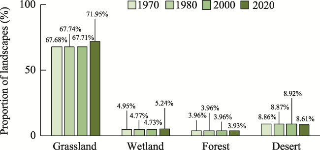
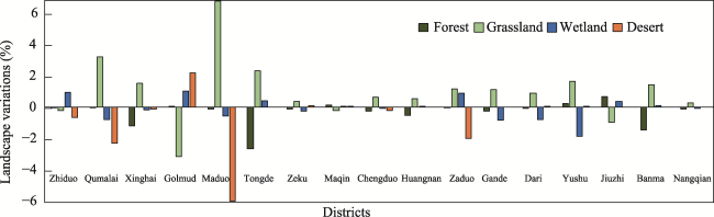
The landscape spatial pattern in Sanjiangyuan region has changed substantially over the past 50 years. This study analysed the implications of variations in grassland, wetland, desert, and forest landscapes during 1970-2020 for ecotourism development in the Sanjiangyuan region by applying satellite remote sensing data, and discussed the factors driving these changes through a literature analysis. The results show that the areas of the four landscape types accounted for 89.7% of the total area of the Sanjiangyuan region in 2020. The most widely distributed landscape type was grassland (71.95%), followed by wetland and desert, and then forest. Under the influence of climate change and human activities, the proportion of these four landscape types increased by 5.01% during 1970-2020. Grassland experienced the largest increase, followed by wetland. In contrast, forests have decreased by 0.83%, and deserts have decreased by 2.79%. The landscape structures of the 17 districts are similar, and they have changed little over the past 50 years. This landscape pattern indicated an overall homogeneity that poses challenges to ecotourism development among those counties, especially with regard to grassland ecotourism, which needs to be a concern of managers.

Cite this article

ZENG Yuxi , ZHONG Linsheng , WANG Ling-en . Changes in the Landscape Pattern in Sanjiangyuan during 1970-2020 and Implications for Ecotourism Development[J]. Journal of Resources and Ecology, 2023 , 14(2) : 230 -238 . DOI: 10.5814/j.issn.1674-764x.2023.02.002

1 Introduction

Ecotourism can contribute to the local economy and nature conservation (Choi et al., 2021). The revenue generated by ecotourism provides major funding for ecosystem protection (Balmford et al., 2009; Watson et al., 2014). Ecotourism promotes the dissemination of ecological knowledge among tourists and local residents, leading to an enhancement of their ecological awareness and environmentally friendly behaviour. As a result, ecotourism is often considered as a desirable development path in ecologically fragile areas with rich tourist attractions.
The natural landscape constitutes the foundation for ecotourism development. As the source of the Yangzi River, Yellow River, and Lancang River, the Sanjiangyuan region is a unique region with global ecological significance and unparalleled landscapes. In recent years, within the context of the construction of national parks in China, ecotourism in the Sanjiangyuan region has attracted increasing attention (Xiang and Zeng, 2017). This region contains large areas of ​​grassland, lakes, rivers, and glaciers, among other significant natural landscapes. Some landscapes in the region have been utilized for aesthetic, recreation, trekking and other ecotourism activities, attracting many tourists and bringing economic benefits to the local communities. Considering Yushu as an example, the number of tourists to Yushu in 2018 was 1.117 million, generating total tourism revenue of 730 million yuan, which represented gains of 24.7% and 26.3% compared to 2017, respectively (General Office of the People’s Government of Yushu Municipality, 2019). Moreover, considering the global interest in its tourist attractions, the Sanjiangyuan region still has tremendous potential for further improvement (Li and Chi, 2014).
Landscape patterns affect the spatial pattern of ecotourism (Tenerelli et al., 2017). Although other factors such as infrastructure and proximity to the demand market also matter, the spatial heterogeneity of the quantity and quality of the natural landscape significantly impacts the spatial distribution of regional tourism development (Weyland and Laterra, 2014). Studies have shown that landscape resources are an important factor in determining the level of tourism development. The area of landscape is an important consideration for the destination choices of tourists (Agimass et al., 2018). Studies have also revealed that the spatial pattern of the tourism market structure in a destination is related to its landscape distribution (Ghermandi et al., 2020). A full understanding of the regional landscape resources is also critical for adopting reasonable strategies, such as tourism development projects. Therefore, the investigation of the spatial pattern of the natural landscape is important to destination decision makers.
The ecosystem of the Sanjiangyuan region is both important and fragile (Zeng et al., 2018). Given its sensitivity to global climate change, the ecosystem of Sanjiangyuan has undergone dramatic changes, with corresponding alterations in the landscapes (Shao et al., 2017; Yuan et al., 2018). Additionally, human activities have also affected landscape patterns in the Sanjiangyuan region (Zhang et al., 2017). On one hand, indiscriminate grazing and mining development have promoted desertification, decreased the grassland area, and particularly expanded the Gobi Desert area (Li et al., 2013). On the other hand, the improvement of an ecosystem also partly depends on human activities. Since 2005, with the advancement of ecological protection and the implementation of diverse construction projects, the grassland and forest areas in the Sanjiangyuan region have gradually increased, while the desert landscape has gradually decreased (Shao et al., 2017).
Most of the previous studies that focused on the evolution of the spatial pattern of ecosystems in the Sanjiangyuan region were conducted from a perspective of conservation (Shao et al., 2017; Yuan et al., 2018; Zeng et al., 2018), and lack the consideration of ecotourism. Therefore, this study aims to: 1) examine the spatial pattern of four ecological landscape types (grassland, wetland, desert, and forest) in the Sanjiangyuan region during 1970-2020; 2) analyse the landscape evolution characteristics and the driving mechanisms; and 3) explore the implications for ecotourism development.

2 Methodology

2.1 Study area

The Sanjiangyuan region is located in the hinterland of the Qinghai-Tibet Plateau, with coordinates 89°45′E-102°23'E and 31°39'N-36°12'N (Fig. 1). Its altitude varies between 2600 and 6800 m. It contains 17 districts (16 counties and one township) and covers an area of about 3.63×10⁵ km2.
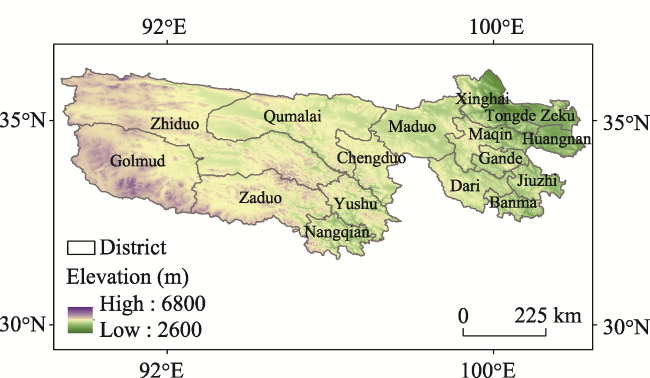
Fig. 1 Location, elevation and districts of the Sanjiangyuan region
As an important part of the Qinghai-Tibet Plateau, the Sanjiangyuan region includes plenty of unique natural landscapes, including forests, snow mountains, glaciers, lakes and alpine valleys. Some of the typical landscapes are shown in Fig. 2. The most famous landscape resources of the region include Hoh Xil, the Nianbao Mountain, the Kunlun Mountain, the Animaqing Mountain, the Zhaling Lake, and the Eling Lake. In 2021, the Sanjiangyuan National Park was established as one of the first national parks in China. In 2017, Hoh Xil was listed as a World Natural Heritage site. These events have made the Sanjiangyuan region an internationally popular ecotourism destination (Xiang and Zeng, 2017). There are four main landscapes that provide recreational opportunities in the Sanjiangyuan region, including grasslands, wetlands, forests and deserts, which form the natural foundation for ecotourism development. However, these landscapes in the region, which are the core of ecotourism, are facing unprecedented threats from climate change. Examples include the melting glaciers, the reduction in vegetation and their corresponding impacts on the local ecosystem.
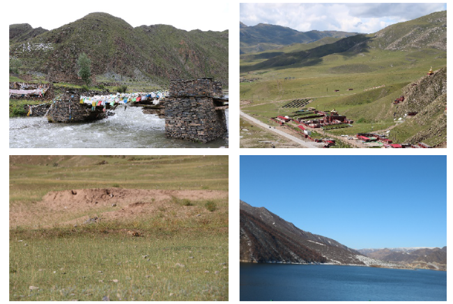
Fig. 2 Some typical landscapes in the Sanjiangyuan region

2.2 Data sources and analysis

2.2.1 Spatial data

In this study, the 17 districts of the Sanjiangyuan region were used as the spatial analysis units. Based on a grid scale, spatial statistical methods were used to analyse the evolution of the spatial distribution patterns of the grassland, wetland, forest, and desert landscapes. The spatial data used for the landscapes in the region consisted of ecosystem data and were divided into four groups with respect to time: 1970, 1980, 2000, and 2020. The data were obtained from the Resource and Environmental Data Centre of the Chinese Academy of Sciences, having been acquired by the visual interpretation of Landsat TM/ETM+ remote sensing images captured between late 1970 and 2020. The data had a spatial resolution of 1 km.
To ensure the quality and consistency of the interpretation of the ecosystem data for each period, the dataset was subject to uniform quality control and inspection. The steps included: 1) field investigations across the districts to obtain a large number of field records and photographs, including drone-captured aerial images; 2) random sampling within a county based on the stratification of the land type and field verification using GF-2 (GaoFen-2 remote sensing data), drone images, and field survey data, to improve the data quality; and 3) integration and quality inspection of the data for the entire region, and improvement of the data quality with the assistance of expert peers. Finally, the classification and overall accuracy of the data were evaluated, and a confusion matrix was used to ensure the reliability and broad applicability of the data.
The ArcGIS software was used to conduct attribute extraction and resampling in order to establish the landscape datasets. Spatial statistical methods such as superposition analysis and grid computing were used to extract the changes in the landscape resources of three periods: 1970-1980, 1981-2000, and 2001-2020. Using the 17 districts and counties as analysis units, the overall characteristics and the differences between the various observed landscape changes in the Sanjiangyuan region during 1970- 2020 were analysed. This analysis used administrative boundary vector data of the Sanjiangyuan region obtained from the China Basic Geographic Information Database.

2.2.2 Literature database

A literature database was used to analyse the reasons for the spatial variations of the landscape pattern in the Sanjiangyuan region. The literature database used in this study was obtained from several full-text databases, including CNKI, Science Direct, and SAGE Journals. The literature published during 1970-2022 were searched through the themes of “Sanjiangyuan”, “landscape”, “ecosystem” and “change”. A total of 182 articles were retrieved and comprehensively analysed to explore the reasons for the changes in landscape in the Sanjiangyuan region between 1970 and 2020.

3 Results

3.1 Landscape spatial pattern in the Sanjiangyuan region

As shown in Fig. 3, the four types of landscapes in the Sanjiangyuan region accounted for 89.73% of the total area by 2020. The most widely distributed landscape type was grassland, which accounted for 71.95% of the total land area; followed by desert and wetland, which accounted for 8.61% and 5.24% respectively. Forest accounted for 3.93%. These four landscape types accounted for more than 80% of the area in each county. The largest proportion was in Banma (99.08%), while the lowest was in Zhiduo (82.64%).
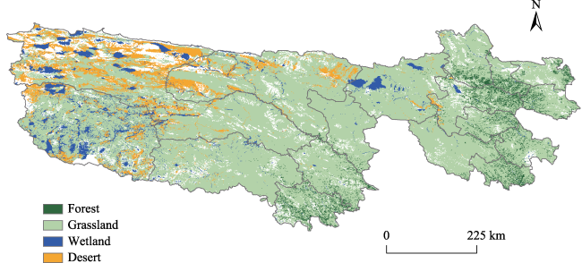
Fig. 3 Landscape distribution in the Sanjiangyuan region in 2020
At the district level, Zhiduo has the largest share of the total landscape of the Sanjiangyuan region (16.94%). However, the proportion of grassland within Zhiduo is the smallest (64.99%) among all the counties. Zhiduo also has the largest proportion of desert (56.89%) of the Sanjiangyuan region, and the proportion of desert within it is also the largest (26.12%) among the 17 districts. These proportions indicate the high potential of Zhiduo for the development of grassland and desert ecotourism.
Golmud has the largest wetland proportion in the Sanjiangyuan region (40.91%). This is where the Jianggudiru Glacier, the source of the Yangtze River, is located. There are a large number of glaciers, forming a dense river network, which is an important eco-tourism attraction. In addition, Maduo has a large area of wetlands, accounting for 10.44% of the wetlands in the whole Sanjiangyuan region. Maduo is known as the “county of thousands of lakes”, with its Zaling Lake and Eling Lake being the two largest lakes in the upper reaches of the Yellow River and great tourist attractions.
Nangqian has the largest forest area, accounting for 18.44% of the total forest in the Sanjiangyuan region, followed by Maqin (15.5%) and Banma (10.16%). These districts are located in the eastern and southern parts of the Sanjiangyuan region.
To summarise, the counties in the western part of the Sanjiangyuan region have more desert landscapes. Wetland constitutes the main ecotourism resource for districts located in the northern and western parts, while the eastern and southern counties have a relative advantage of forest landscapes.

3.2 Variations of the landscape spatial pattern in Sanjiangyuan region

3.2.1 Overall dynamic characteristics

Figure 4 shows that the total proportion of these four landscapes in Sanjiangyuan region has increased from 85.45% in 1970 to 89.73% in 2020. This enlargement is a combined result of the changes in various types of landscapes (see Fig. 5).
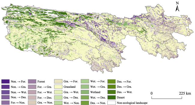
Fig. 4 Landscape transformations in the Sanjiangyuan region during 1970-2020

Note: For., forest; Gra., grassland; Wet., wetland; Des., desert; Non., non-ecological landscape; the full name of a landscape indicates no conversion.

Fig. 5 Changes in the four ecotourism landscape types in the Sanjiangyuan region during 1970-2020
The main landscape changes in the Sanjiangyuan region during 1970-2020 were characterised by grassland increase. During 1970-2020, the areas of grassland that were transformed from non-ecological landscapes accounted for 52.91% of the overall transformation areas. During 1970- 1980, 1981-2000, and 2001-2020, the grassland landscape experienced a process of ‘reduction-expansion-reduction’, as it switched from a proportion of 67.68% of the Sanjiangyuan region in 1970 to 71.95% in 2020. Another obvious evolu tionary trajectory is the increase in the wetland landscape. During 1970-2020, the areas of wetland that were transformed from non-ecological landscapes accounted for 9.57% of the overall transformation areas. The wetland landscapes experienced a process of ‘reduction-reduction- expansion’, and the expansion during 2001-2020 was relatively large. The deserts were reduced by 2.79%. Although there was an increase in the area of deserts during 1970- 2000, it experienced a significant decline in 2001-2020. The forest landscapes experienced the smallest changes, with a reduction rate of 0.74%. The forest area increased until 1980, but declined thereafter.

3.2.2 Spatial pattern changes in the main types of landscapes

From 1970 to 2020, 24.44% of the landscapes in Sanjiangyuan area were transformed. The conversion of non-landscape to grassland was the main reason for the growth of grassland, which accounts for 56.87% of the total grassland growth area, and mainly occurred in Qumalai. Wetland growth mainly came from grassland, which accounts for 60.18% of the total wetland growth area, mainly in Golmud City. The growth of forest land mainly came from grassland, which accounts for 93.86% of the total forest land growth area, mainly in Nangqian. The growth of desert mainly came from grassland, which accounts for 66.25% of the total desert growth area, mainly in Zhiduo.
Of the area of grassland transferred out, the largest component was conversion to non-landscape, and this part of the area accounts for 38.74% of the total area of grassland transferred out, mainly in Zhiduo. The conversion of wetland to grassland was the main direct cause of wetland reduction, and this part of the area accounts for 63.36%, mainly in Golmud. The conversion of forest land to grassland was the main direct reason for the reduction of forest land, which accounts for 95.63% of the area, mainly in Nangqian. The conversion of desert to grassland was the main direction of desert reduction, accounting for 66.62%, mainly in Zhiduo.

3.2.3 Dynamic characteristics of the landscapes in each district

During 1970-2020, only minor changes happened in the landscape structures of the 17 districts, and only the scale changed. According to their landscape structures, the districts can be classified into four categories based on their structures (Fig. 6): 1) category 1, with grassland, desert, wetland, and forest in descending order; 2) category 2, with grassland, forest, wetland and desert in descending order; 3) category 3, with grassland, wetland, desert, forest in descending order; and 4) category 4, with grassland, forest, desert and wetland in descending order. Although grassland is the main landscape in all four types of areas, they show different landscape structure characteristics.
Fig. 6 Landscape variations in the 17 districts during 1970-2020
Category 1 includes Zhiduo and Qumalai, which is characterized by large deserts. From 1970 to 2020, the areas of deserts in these two districts continued to shrink. In addition, forests were shrinking. In terms of wetlands, the wetlands in Zhiduo increased, but the wetland area in Qumalai decreased. The grassland in Zhiduo decreased slightly, and the grassland in Qumalai increased.
Category 2 includes Xinghai, Tongde, Zeku, Chengduo, Huangnan, Gande, Dari, Yushu, Jiuzhi, Banma and Nangqian, which is characterized by a large forest area. From 1970 to 2020, the forest areas of Xinghai, Tongde, Zeku, Zaduo, Huangnan, Gande, Dari, Banma and Nangqian faced varying degrees of reduction, while the forest land areas of Yushu and Jiuzhi were increasing. The grassland areas of Xinghai, Tongde, Zeku, Chengduo, Huangnan, Gande, Dari, Yushu, Banma and Nangqian increased, and that of Jiuzhi decreased. The wetland areas of Xinghai, Zeku, Chengduo, Gande, Dari, Yushu and Nangqian decreased, and those of Tongde, Huangnan, Jiuzi and Banma increased. The deserts in Xinghai, Tongde, Chengduo, Huangnan, Gande, Jiuzhi, Banma and Nangqian decreased, and those in Zeku, Dari and Yushu increased.
Category 3 includes Golmud, Maduo and Zaduo. This category is characterized by a large wetland area. From 1970 to 2020, the wetlands in Golmud and Zaduo increased, while those in Maduo decreased. In addition, the forest areas of Golmud increased, and those of Maduo and Zaduo decreased. The grassland in Golmud shrank, while the grassland in Maduo and Zaduo increased. The desert in Golmud increased, and those in Maduo and Zaduo decreased.
Category 4 includes Maqin. The forest and desert areas of Maqin expanded gradually, while the grassland area and wetland area decreased slightly.

3.3 Driving mechanism of landscape evolution in Sanjiangyuan region

The literature review showed that climate change and human activities (e.g., recreation, ecological engineering) were the two main factors driving landscape changes in the Sanjiangyuan region (Shao et al., 2017; Bai et al., 2020; Jin et al., 2020). Global warming has resulted in annual shrinking of the glaciers and snow-capped mountains in the Sanjiangyuan region, directly affecting the water supplying to lakes and wetlands (Lv et al., 2009). The areas of many lakes and wetlands have shrunk and some have dried up, marshes have disappeared, and the ecological environment has become fragile (Xu et al., 2008). Due to the sparse population of the Sanjiangyuan region, human activity has had less impact on the natural elements (Liu and Shao, 2014; Sun et al., 2016). During the greening period of grassland vegetation in the Sanjiangyuan region in 2003-2012, an “advance-delay-advance-re-postponed” sequence of changes occurred and was affected by various factors such as light, temperature, and precipitation (Han et al., 2019). Although the academic community generally believes that climate change significantly impacts the ecosystem in the Sanjiangyuan region, there has been no agreement on its specific contribution. Previous studies have shown that the rates of climate change effects on the different ecosystem elements in the Sanjiangyuan region were between 38.1% and 180% during 1970-2012 (Shao et al., 2017). At the source of the Yellow River in the Sanjiangyuan region, climate change contributed 70% to changes in the runoff. The correlation coefficients of grassland ecosystem and temperature were between 0.515-0.802. Between 1982 and 2013, climatic conditions contributed an average of 87% to changes in the vegetation productivity, while human activities contributed only 13% (Li et al., 2016). During 2001-2010, climate conditions and human activities respectively contributed 79.32% and 20.68% to changes in vegetation growth in the region (Li et al., 2011).
Compared to climate change, human activities have less effect on ecosystem changes in the Sanjiangyuan region (Liu and Shao, 2014; Shao et al., 2017). The impact of human activities on landscape resources in the region during the study period can be roughly divided into two phases (Shao et al., 2017). In the first stage between 1970 and 2005, human activities caused reductions in grassland, wetland, and forest land, and increased the amount of desert. In the second stage from 2005 to 2020, the amounts of grassland, wetland, and forest increased, and the amount of desert decreased. The ecological engineering efforts introduced since 2005 have led to some increases in wetland and areas changing from desert to grassland (Shao et al., 2017). The ecosystem has become gradually healthier. Under the effects of climate change and human activities, grassland, wetland, and forest land in the Sanjiangyuan region are expected to further increase in the future.

4 Discussion

4.1 Potential landscape for ecotourism in the Sanjiangyuan region

The results of our analysis show that the large-scale natural landscapes of the Sanjiangyuan region provide an excellent foundation for ecotourism development, echoing the findings of previous studies (Xiang and Zeng, 2017). The present study provides spatially explicit evidence for this point. About 89.73% of the Sanjiangyuan region was determined to have landscape with good potential for ecotourism development. In addition, an analysis of the landscape pattern evolution and its driving mechanism indicate that these ecotourism resources will not decrease in the future.
The grassland landscape in the Sanjiangyuan region is substantial, providing great potential for grassland ecotourism. Grassland is the main ecotourism resource in the region, occupying more than half of the total area. The well-recognized grasslands include Batang Grassland, Jialuo Grassland, Jiatang Grassland, Marco River Grassland, and Madoka Bay. There has been recent development in the ecotourism activities in Batang Grassland (Peng and Wu, 2002). In recent years, the number of grassland landscapes has gradually increased, providing a better resource base for the further development of grassland ecotourism.
Although wetland is not the largest landscape in the Sanjiangyuan region, such resources are very important for China and Asia. The Sanjiangyuan region is the origin of the Yangtze River and the Yellow River, which is considered as the source of Chinese civilisation. The Lancang River, known as the Mekong River when it enters Southeast Asia, also originates from the Sanjiangyuan region. The region thus has a strong appeal to the people of Southeast Asia. Famous wetlands of the Sanjiangyuan region include the source of the Yangtze River, the source of the Yellow River, the source of the Minjiang River, the Weihe River, the Zhaling-Eling Lakes, Dangqu, Guzong Liqu, and Xingsuhai. These resources have significant potential for the development of wetland ecotourism, such as river tracing activities, wetland sightseeing, wetland photography, and wetland scientific research. The present wetland ecotourism resources in the Sanjiangyuan are mainly developed around the Weihe River and Zhaling-Eling Lakes (Li et al., 2009; Song and Zhong, 2009). In recent years, the wetlands in the Sanjiangyuan region have experienced expansion, as a result of climate warming and ecological conservation. However, the wetlands here are mainly recharged by glacial meltwater. If the climate further warms in the future, the glaciers will melt more and disappear, which may cause the wetlands to lose their recharge (Ji and Yuan, 2018).
Desert landscapes have decreased in recent years. Ecological engineering initiatives have focused on optimising the ecosystem function with the aim of suppressing desertification. Combined with climatic change, the ecological engineering activities are expected to continue to reduce the amount of desert landscapes in the region. Nevertheless, from an ecotourism development perspective, the desert resources do have recreational value. In the unique Sanjiangyuan region, they are also very valuable for the development of ecological education. Unreasonable human exploitation and development accelerate the transformation of grassland and forest ecosystems into desert ecosystems, while ecological engineering promotes the restoration of vegetation through the construction of grass checks and conservation forests. These activities can be presented to eco-tourists through holographic images, publications, and on-site visits to enhance ecological awareness and civilisation.
The forest landscapes in the Sanjiangyuan region are small-scale. Along the height of the plateaus, from bottom to top, there are forest grassland, meadow belt-cold-temperate coniferous forest, belt-alpine shrub forest, belt-alpine meadow, and belt-mountain grassland, forming a vertical forest belt landscape. The diversity of the forests in the Sanjiangyuan region is relatively low. Current forest ecotourism developments in the region include the Baizha Forest Farm and Maixiu Forest Farm. There has been a decrease in the forest landscape resources during the study period, posing a threat to further forest ecotourism development.

4.2 Significance of the landscape spatial pattern to coordinating ecotourism in different counties

Grassland is the main ecotourism attraction for the 17 districts in the Sanjiangyuan region, exposing these districts to the challenges of homogeneity. Homogeneity is a major challenge faced by districts in the Sanjiangyuan region. The results showed that this homogeneity is partly due to the large scale of one kind of landscape, such as grassland, which results in a lack of variety in the visual sense that may make tourists feel aesthetic fatigue. In addition, the limited ecotourism activities have also contributed to this homogeneity. The main ecotourism activities in the study areas were sightseeing, which largely rely on the visual experience. As mentioned above, these districts have the potential to develop more activities based on their unique resources, such as environmental education and river-source seeking. Diversifying ecotourism activities according to the characteristics of the landscape and its changing stories could be a solution to this homogeneity problem.
The desert landscapes were mainly distributed in Zhiduo and Qumalai. The landscape homogeneity also poses limitations on their ecotourism development, but the transformation of the landscape could provide solutions. For example, Zhiduo has seen the transformation of desert into wetland in recent years, and the success of ecosystem restoration could provide a natural site for the ecological education of eco-tourists. In addition, regional cooperation is a potential option for these counties. Cooperating with an adjacent county that has a different landscape offers opportunities to diversify ecotourism. For example, Qumalai can cooperate with Maduo to develop ecotourism routes that combine wetland and deserts.
The wetland landscapes in Maduo, Golmud, and Zaduo are widely distributed, especially in Maduo. This county has the two largest lakes in the upper reaches of the Yellow River, namely Zhaling Lake and Eling Lake, which are the main ecotourism attractions in the Sanjiangyuan region. More importantly, it is necessary to focus on ecosystem degradation in these counties. The most significant landscape change in Zaduo in recent years was the transformation from wetland into grassland, and the wetland ecotourism development in the county should avoid these sensitive areas.
The forest landscapes were mainly distributed in Xinghai, Tongde, Zeku, Chengduo, Huangnan, Gande, Dari, Yushu, Jiuzhi, Banma and Nangqian. Forest ecotourism is not the main ecotourism activity in the Sanjiangyuan region, so these counties have some advantages for attracting ecotourism through forest-based activities compared to the other counties. Also, conservation concerns should be emphasized in this area, because some unhealthy ecosystem changes have been occurring during the study period. For example, the most remarkable landscape change in Banma in recent years has been the transformation from forest into grassland. Therefore, ecotourism activities that have risks of ecosystem destruction should be discouraged.
In conclusion, the landscape homogeneity in the Sanjiangyuan region is likely to bring about competition among the counties in the development of ecotourism, such as the grassland tourism of most counties, desert tourism of Zhiduo and Qumalai, wetland ecotourism of Maduo and Zaduo, as well as forest ecotourism of Xinghai and Tongde. Diversifying into a multi-functional ecotourism destination based on unique resources or locations could be conducive to counties achieving more resilience and sustainability, and the most important consideration is conservation protection. The ecosystem of the Sanjiangyuan region is very fragile, and unreasonable exploitation will cause ecosystem degradation and jeopardize the foundation of ecotourism. Therefore, large-scale ecotourism is not appropriate for the Sanjiangyuan region. Instead, ecotourism activities with ecological knowledge and environmental awareness should be encouraged. To better accommodate ecotourism, the tourism-related facilities need to be provided under strict environmental impact assessments.

5 Conclusions

Ecotourism, which is based on natural landscapes, is important for the Sanjiangyuan region. An understanding of the changing pattern of natural landscapes can improve decision making by ecotourism managers. Previous studies have examined the evolution of the spatial pattern of the ecosystems in the region and the underlying factors, but did not consider the implications of these changes for ecotourism, especially from the county perspective. In the present study, the implications for ecotourism are discussed based on analyses of the spatial pattern changes of grassland, wetland, forest, and desert in the Sanjiangyuan region. Satellite remote sensing data were used to describe the changing patterns of the landscapes, and the factors affecting these changes were derived from literature reviews.
The results show that the four landscape types (grassland, wetland, forest, and desert) accounted for 89.7% of the total area of the Sanjiangyuan region. Grassland was the predominant landscape type, followed by wetland, desert, and then forest. This diversity constitutes a good resource foundation for ecotourism development in the region. Although they are not the main landscape type, the wetlands in the Sanjiangyuan region have their own unique value in China and around the world, and offer great opportunities for wetland ecotourism development. The grasslands in the Sanjiangyuan region cover a large scale, providing a good foundation for grassland ecotourism. With the variations of the deserts in the region in recent years, the opportunities for desert ecotourism and related environmental education activities have gradually arisen. The forest resources in this region are limited, but the vertical forest belt landscapes could be potentially attractive. However, the shrinkage of forests in the study period poses a challenge to forest ecotourism development.
The total areas of natural landscape have increased from 1970 to 2020, with the proportion of natural landscapes growing from 85.45% in 1970 to 89.73% in 2020. This expansion has mainly been due to the increase in grassland. A large amount of non-ecological landscapes has been transformed into grassland. An increase in natural landscape also occurred in wetlands. Wetland growth mainly came from grassland.
Despite the overall landscape changes across the Sanjiangyuan region, the landscape pattern of each district has been relatively stable and they are highly similar to each other, indicating a homogeneity challenge to ecotourism development, especially in grassland ecotourism. Moreover, considering the sensitivity and fragility of most ecosystems in the region, future ecotourism development should be limited to those spaces with the environmental capacity and sufficient resources to carry out ecotourism activities. Usually, such a space has a small area and needs to have the necessary built-up facilities for eco-tourist accommodation. As for the specific types of ecotourism activities, those which have less negative environmental impacts and more ecological awareness need to be encouraged, such as environmental education and river-source seeking.
The present study has several limitations. First, the study period does not include the latest years. The most current data can offer more recent information about natural landscape changes, which is considered to be the most useful for ecotourism decision making. Actually, while the latest information is important, an analysis of the past variations is also relevant for allowing managers to identify what kind of situation is likely to be stable and achievable in light of the changing environment. Given that, future studies could extend the study period used in this study and conduct comparative research between the latest period and past periods. Second, this study only considers four types of landscapes, but more detailed landscapes, such as rivers, lakes and glaciers, need to be further explored, especially under climate change. In addition, efforts should be made to go beyond the qualitative analysis of the implications of the spatial pattern changes for ecotourism development. Due to the lack of data on eco-tourists to Sanjiangyuan region, there is still limited quantitative evidence for the impacts of landscape changes on ecotourism. Recently, some approaches have been introduced to analyse areas with limited statistical data, such as public participation geographic information systems or PPGIS. Therefore, it is important for future studies to apply quantitative research in the analysis of the impacts on ecotourism under a changing landscape.

This work was also supported by The Youth Innovation Promotion Association.

[1]
Agimass F, Lundhede T, Panduro T E, et al. 2018. The choice of forest site for recreation: A revealed preference analysis using spatial data. Ecosystem Services, 31(SI):445-454.

[2]
Bai Y, Guo C, Degen A A, et al. 2020. Climate warming benefits alpine vegetation growth in Three-River Headwater Region, China. Science of the Total Environment, 742: 140574. DOI: 10.1016/j.scitotenv.2020.140574.

[3]
Balmford A, Beresford J, Green J, et al. 2009. A global perspective on trends in nature-based tourism. Plos Biology, 7: e1000144. DOI: 10.1371/journal.pbio.1000144.

[4]
Choi Y E, Oh C O, Chon J. 2021. Applying the resilience principles for sustainable ecotourism development: A case study of the Nakdong Estuary, South Korea. Tourism Management, 83: 104237. DOI: 10.1016/j.tourman.2020.104237.

[5]
General Office of the People’s Government of Yushu Municipality. 2019. Government Work Report of Yushu Tibetan Autonomous Prefecture. Yushu, China. http://www.yushuzhou.gov.cn/html/1387/284816.html (accessed on 2019/3/11).

[6]
Ghermandi A, Camacho-Valdez V, Trejo-Espinosa H. 2020. Social media-based analysis of cultural ecosystem services and heritage tourism in a coastal region of Mexico. Tourism Management, 77: 104002. DOI: 10.1016/j.tourman.2019.104002.

[7]
Han B H, Zhou B R, Zhao H H, et al. 2019. Relationships between grassland vegetation turngreen and climate factors in the Three-River Resources Region. Acta Ecologica Sinica, 39(15): 5635-5641. (in Chinese)

[8]
Ji P, Yuan X. 2018. High-resolution land surface modeling of hydrological changes over the Sanjiangyuan region in the eastern Tibetan Plateau: 2. Impact of climate and land cover change. Journal of Advances in Modeling Earth Systems, 10(11): 2829-2843.

[9]
Jin Z, You Q L, Wu F Y, et al. 2020. Changes of climate and climate extremes in the Three-Rivers Headwaters’ Region over the Tibetan Plateau during the past 60 years. Transactions of Atmospheric Sciences, 43(6): 1042-1055.

[10]
Li H X, Liu G H, Fu B J. 2011. Response of vegetation to climate change and human activity based on NDVI in the Three-River Headwaters Region. Acta Ecologica Sinica, 31(19): 5495-5504. (in Chinese)

[11]
Li J, Cheng S K, Ma J G, et al. 2009. Investigating modes for poverty elimination through developing tourism resources at county levels in the Sanjiangyuan region. Resources Science, 31(11): 1818-1824. (in Chinese)

[12]
Li R, Chi X. 2014. Thermal comfort and tourism climate changes in the Qinghai-Tibet Plateau in the last 50 years. Theoretical and Applied Climatology, 117(3-4): 613-624.

[13]
Li X L, Perry G L W, Brierley G, et al. 2013. Restoration prospects for Heitutan degraded grassland in the Sanjiangyuan. Journal of Mountain Science, 10(4): 687-698.

[14]
Li Z W, Wu R J, Ma Y P. 2016. Impact of climate change and human activities on vegetation productivity in the Three-River Headwaters. Journal of Glaciology and Geocryology, 38(3): 804-810. (in Chinese)

[15]
Liu Z J, Shao Q Q. 2014. Vegetation coverage change and its response to climate change in Three-River Headwaters Region. Research of Soil and Water Conservation, 21(6): 334-339.

[16]
Lv A F, Jia S F, Yan H Y, et al. 2009. Temporal variations and trend analysis of the snowmelt runoff timing across the source regions of the Yangtze River, Yellow River and Lancang River. Resources Science, 31(10): 1704-1709. (in Chinese)

[17]
Peng D, Wu H. 2002. On tourist resources and exploitation in the Cuola geyser area, Batang, Sichuan. Acta Geologica Sichuan, 4: 240-243.

[18]
Shao Q, Cao W, Fan J, et al. 2017. Effects of an ecological conservation and restoration project in the Three-River Source Region, China. Journal of Geographical Sciences, 27(2): 183-204.

[19]
Song Z W, Zhong L S. 2009. ATOS methods for investigating suitability of the conversion between adventure tourism resources and products over the Sanjiangyuan region. Resources Science, 31(11): 1832-1839. (in Chinese)

[20]
Sun Q L, Li B L, Xu L L, et al. 2016. Analysis of NDVI change trend and its impact factors in the Three-River headwater region from 2000 to 2013. Journal of Geo-information Science, 18(12): 1707-1716. (in Chinese)

[21]
Tenerelli P, Püffel C, Luque S. 2017. Spatial assessment of aesthetic services in a complex mountain region: Combining visual landscape properties with crowdsourced geographic information. Landscape Ecology, 32(5): 1097-1115.

[22]
Watson J E M, Dudley N, Segan D B, et al. 2014. The performance and potential of protected areas. Nature, 515: 67. DOI: 10.1038/natu re13947.

[23]
Weyland F, Laterra P. 2014. Recreation potential assessment at large spatial scales: A method based in the ecosystem services approach and landscape metrics. Ecological Indicators, 39: 34-43.

[24]
Xiang B H, Zeng Y X. 2017. Ecotourism construction and operating mechanism in the Sanjiangyuan National Park system pilot area, China. Resource Science, 39(1): 50-60. (in Chinese)

[25]
Xu X L, Liu J Y, Shao Q Q, et al. 2008. The dynamic changes of ecosystem spatial pattern and structure in the Three-River Headwaters Region in Qinghai Province during recent 30 years. Geographical Research, 27(4): 829-838. (in Chinese)

[26]
Yuan X, Ji P, Wang L, et al. 2018. High-resolution land surface modeling of hydrological changes over the Sanjiangyuan region in the eastern Tibetan Plateau: 1. Model development and evaluation. Journal of Advances in Modeling Earth Systems, 10(11): 2806-2828.

[27]
Zeng Y X, Zhong L S, Wang L E. 2018. Spatiotemporal changes in recreation potential of ecosystem services in Sanjiangyuan, China. Journal of Spatial Science, 63(2): 359-377.

[28]
Zhang Y, Zhang C B, Wang Z Q, et al. 2017. Quantitative assessment of relative roles of climate change and human activities on grassland net primary productivity in the Three-River Source Region, China. Acta Prataculturae Sinica, 26(5): 1-14. (in Chinese)

Outlines

/