Ecosystem Assessment

Ecological Sensitivity Assessment of the Southeastern Qinghai-Tibet Plateau using GIS and AHP—A Case Study of the Nyingchi Region

  • WANG Yongxiang , 1, 2 ,
  • WEI Jiaxuan 1, 2 ,
  • ZHOU Juan 1, 2 ,
  • YANG Jiajia 1, 2 ,
  • XU Yuanyuan 1, 2 ,
  • CHEN Yuxin 1, 2 ,
  • HAO Jiangcheng 3 ,
  • CHENG Wuxue , 1, 2, *
Expand
  • 1. Key Laboratory of Evaluation and Monitoring of Southwest Land Resources, Ministry of Education, Sichuan Normal University, Chengdu 610066, China
  • 2. College of Geography and Resource Science, Sichuan Normal University, Chengdu 610066, China
  • 3. Xi’an Yirun Wenjing Planning and Design Co., LTD, Xi’an 710000, China
*CHENG Wuxue, E-mail:

WANG Yongxiang, E-mail:

Received date: 2021-08-11

  Accepted date: 2022-04-30

  Online published: 2023-01-31

Supported by

The National Natural Science Foundation of China(32060370)

The Science Foundation of Ministry of Education of The People’s Republic of China(18YJC850004)

Abstract

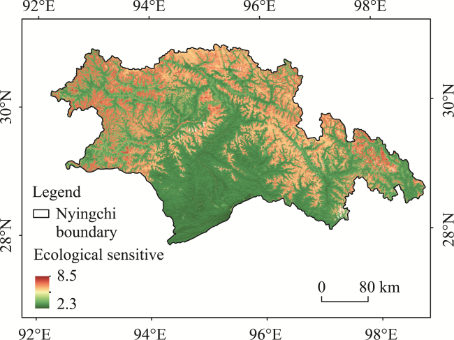
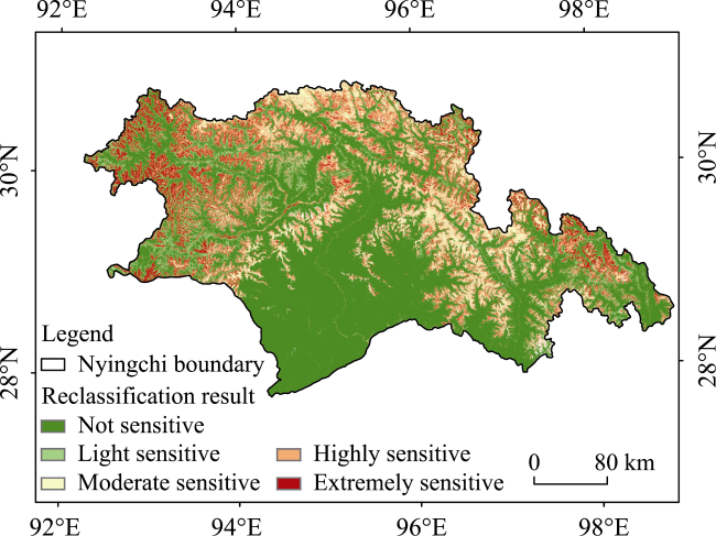
This paper took the Nyingchi area in southeastern Tibet Autonomous Region of China as the research area, and selected five indicators of elevation, slope, slope direction, normalized difference vegetation index (NDVI) and water body as the evaluation system based on the current situation of domestic and foreign research and field investigation. The indicators were analyzed by the AHP method for weighting, and then an ArcGIS overlay analysis was applied. The results show that the ecological sensitivity of the Nyingchi region is generally increasing from the south of Nyingchi to the north of Nyingchi. The northern, western and southwestern parts of Nyingchi are extremely sensitive or highly sensitive, while the southern part is mostly insensitive or mildly sensitive ecologically. The proportions of areas for each sensitivity level are: not sensitive 54.81%, light sensitive 11.97%, moderately sensitive 10.34%, highly sensitive 8.65%, and extremely sensitive 14.23%. The results indicate that the overall ecological sensitivity of the Nyingchi region is low and this region is performing well with respect to ecological environmental protection. This study can provide some suggestions for targeted improvements of the ecological environmental protection in the Nyingchi region and even in the Tibetan Plateau region.

Cite this article

WANG Yongxiang , WEI Jiaxuan , ZHOU Juan , YANG Jiajia , XU Yuanyuan , CHEN Yuxin , HAO Jiangcheng , CHENG Wuxue . Ecological Sensitivity Assessment of the Southeastern Qinghai-Tibet Plateau using GIS and AHP—A Case Study of the Nyingchi Region[J]. Journal of Resources and Ecology, 2023 , 14(1) : 158 -166 . DOI: 10.5814/j.issn.1674-764x.2023.01.015

1 Introduction

The increasing exploitation and use of our blue planet in the 21st century by humans has led to a series of new ecological and environmental problems at both global and small regional scales (Ouyang et al., 2000). The thawing of permafrost has led to the release of large amounts of mercury which harms animals and plants, and climate change has led to changes in the carbon storage capacity of Antarctic benthic organisms (Sutherland et al., 2019). Under the combined action of these and other emerging ecological problems, as well as the substantial reduction of forest area, soil erosion and soil salt moraine in the past (Yang et al., 2020; Chen et al., 2021), ecological environmental problems are having a significant impact on global development. Therefore, the prevention and remediation of ecological deterioration is an urgent problem for all of us. In the reports of the 19th National Congress of the Communist Party of China, the Chinese government has also put forward the protection of the ecological system, pushing forward the continuous construction of major ecological protection and restoration projects (Liu et al., 2021a) to improve ecosystem quality and stability. It is of important practical significance to study the ecological environmental sensitivity of China’s ecological civilization with beautiful Chinese construction, in order to guide the ongoing social and economic development.
Studies on ecological sensitivity in foreign countries began earlier than those in China. Most foreign scholars have focused on the sensitivity of wetlands to climate change, the sensitivity of hydrological systems to climate change, and the sensitivity of coastal zones to climate change. At the same time, they tend to choose large regions and large scales to evaluate and study (Zhou et al., 2021). For example, Eggermont et al. (2010) found that climate warming would lead to ecological vulnerability of the lakes in the Rwenzori Mountains. Garrod et al. (1999) calculated the value of ecologically sensitive areas. The research on ecosystem sensitivity is also increasing in China, and the research method has changed from the initial ecological sensitivity analysis, so that the current research scale of our scholars is mainly urban or larger scales. Ouyang divided the territory of China into different regional units and analyzed the laws that differentiate each of the regional units. Liu et al. (2015) constructed evaluation indicators and evaluation models related to terrestrial ecosystems and divided the protection red lines of ecologically sensitive areas in China. Tang et al. (2017) evaluated the ecological sensitivity of northern Shanxi.
With the development of science and technology, the application of Geographic Information System (GIS) to ecological sensitivity assessments has made our data acquisition and management more comprehensive. The final evaluation results are also more sophisticated. For example, Zhou et al. (2016) evaluated the ecological sensitivity of the Xiaoqing River watershed in Jinan using overlay analysis and buffer zone analysis with ArcGIS, and Cui et al. (2021) studied the Dalinore Lake watershed on the Inner Mongolia Plateau using soil erosion sensitivity indicators, land sanding sensitivity indicators, and watershed sensitivity indicators.
Current studies on the Nyingchi area are mostly focused on the geological hazards (Chen et al., 2019; Guo et al., 2021) and climate (Duan et al., 2017; Zhang et al., 2018) of the Nyingchi area. Few studies have selected multiple factors for analyzing the ecological sensitivity of the Nyingchi region. Therefore, there is an urgent need to carry out a study based on the actual situation and characteristics of the Nyingchi area. In this paper, the whole Nyingchi region in the southeast of the Tibet Autonomous Region is selected as the research object. We conducted experiments and evaluations on the basis of fieldwork and a review of the related literature (Gan et al., 2018; Ventura et al., 2018; Jiang et al., 2021; Liu et al., 2021b) to analyze the main ecological environment problems and identify ecologically sensitive areas in the Nyingchi region, and then to propose corresponding conservation measures. The results of this study can provide a basis for the sustainable development of the Nyingchi region and are of great scientific significance for the harmonious development of man and nature in the highland region.

2 Study area, data and methods

2.1 Characteristics of the study area

The research area is located in the Nyingchi region in the southeast of the Tibet Autonomous Region of China (Fig. 1). Nyingchi in Chinese is transliterated from the Tibetan “nyang khri”, which means “the throne of the Niang family” (Wei, 2018). Since 1951, it was translated as “Nyingchi” by the mapping team members according to the local products and characteristics. Nyingchi is 646 km long from east to west and 353 km wide from north to south. Nyingchi is 400 km from Lhasa, the capital of the Tibet Autonomous Region.
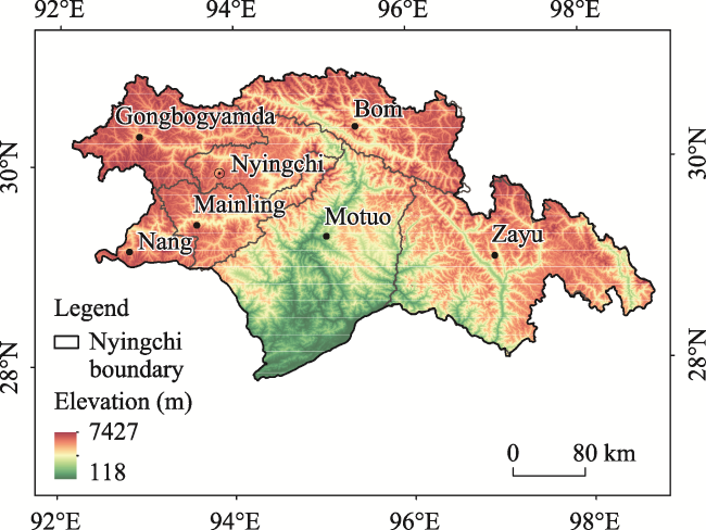
Fig. 1 Overview of the study area
Nyingchi is located in the middle and lower reaches of the Yarlung Tsangpo River, bordering both India and Myanmar. In 2020, the total population of Nyingchi was 238900, among which the Tibetan people are the main group, although 35 ethnic groups, including the Han Chinese and Lhoba ethnic groups, live there together. Compared with other places of the same latitude, the temperature in Nyingchi is relatively high and the annual and diurnal temperature range is relatively low. Water vapor is abundant in Nyingchi. The rainy season starts from June to August and ends at the end of September, so it lasts a long time and yields a great deal of precipitation. Unlike the nighttime rainfall in Lhasa during the rainy season, the rainfall in Nyingchi is irregular and continuous and the average annual precipitation in most areas is between 500 and 1000 mm. However, due to the influence of topography, there are great differences among different regions. The rainfall is less in the western part of the Yarlung Zangbo River, which is dry with less than 500 mm of precipitation, while the area with more rainfall is located in Medog County in the Himalayan Department, with more than 2000 mm. Nyingchi area has about 522 km2 of rivers, accounting for 0.46% of the total land area. Nyingchi region has two major river systems, the Yarlung Tsangpo River and the Nujiang River, and other smaller rivers, such as the Jitaiqu River. The rivers and streams slope from north to south due to the terrain, and the rivers flow southward and out of the country.

2.2 Data sources

The data used in this study to assess the ecological sensitivity of Nyingchi area are as follows: DEM data of type ASTER GDEM with a resolution of 30 m×30 m from the Geospatial Data Cloud Platform of the Computer Network Information Center of the Chinese Academy of Sciences (http://www.gscloud.cn); and theNDVI data in Nyingchi were extracted from the Landsat 8 data set (Landsat/ LC08/C01/T1_SR) in the online database by using the Google Earth Engine (GEE) of Google Inc. After the images from April to July 2021 were synthesized and the maximum value was obtained, the cloud removal mask was used to remove clouds and calculate the NDVI. The vector boundary data of the Tibetan Plateau were obtained from the “National Tibetan Plateau Scientific Data Center” (http://data.tpdc.ac.cn).

2.3 Research methods

2.3.1 Selection of ecologically-sensitive factors

In the calculation of the ecological sensitivity degree within the Nyingchi area, five sensitivity factors of elevation, slope, aspect, NDVI and water area were selected and assigned according to the Interim Regulations for Ecological Function Areas issued by the State Environmental Protection Administration (SEPA), based on a survey of the domestic and foreign literature and conducting fieldwork in Tibet.
Table 1 Ecological sensitivity assessment factors and their classifications
Level The evaluation factors
Altitude (m) Slope (°) Aspect NDVI Distance from water (m)
1 <1500 0-10 Plane, south 0.5-1.0 -
2 1500-2500 10-25 Southeast, southwest 0.3-0.5 >1000
3 2500-3800 25-45 East, west 0-0.3 500-1000
4 3800-4500 45-60 Northeast, northwest -1.0-0 200-500
5 >4500 >60 North - 0-200

2.3.2 Normalized Difference Vegetation Index

The ideal image for determining NDVI would be one from the remote sensing satellite sensors with the relative position of the sun to the terrain at three fixed wavelengths, and one that is not affected by atmosphere and so on. If the signal received by the remote sensing satellite sensor without any loss or noise impact on the plant’s leaf tissue has a strong absorption for the 470 nm blue light and 650 nm red light, and a strong reflection for the green light, then the plant appears green, while the back of the leaf also has a strong reflection for 700-1000 nm near-infrared light. In this case, we can use the following formula to calculate the Normalized Vegetation Index:
$NDVI=\frac{NIR-R}{NIR+R}$
where NIR represents the near infrared albedo of the remote sensing image, and R represents the red band albedo of the remote sensing image. We used this formula to calculate NDVI in this study.
In order to eliminate the influence of the atmosphere and other factors on the NDVI in Nyingchi, the maximum value synthesis algorithm (MVC) was used to eliminate both the internal and external noise.

2.3.3 Ecological sensitivity factor weight calculation

In order to determine the weight of each evaluation factor, the Analytic Hierarchy Process (AHP) was chosen for this experiment. The AHP was first proposed by Saaty (2004), an American operations research scientist. It divides the factors that help people to make decisions into different levels such as objectives, criteria, and solutions, and then performs qualitative or quantitative analysis on this basis. In addition, there are generally no more than nine elements per layer. It consists of the following two steps.
(1) Construct the discriminant matrix
The criteria in the criteria layer have different levels of importance for the target measurement, so the numbers 1, 2, 3, …, 9 and their reciprocals can be used as scales as shown in Table 2.
Table 2 The scale of each criterion
Scale Meaning
1 The two factors are equally important
3 The two factors are slightly more important than the former
5 The two factors are obviously more important than the former
7 The two factors are more strongly important than the former
9 The two factors are extremely important compared to the former
2, 4, 6, 8 Importance is in the middle of the above judgment levels
Reciprocal If the ratio of the importance of factor i to j is A, then the
ratio of the importance of factor j to i is B

Note: Scale means how important an indicator is when compared in pairs, with odd numbers 1, 3, 5, 7, and 9 indicating varying degrees of importance, and even numbers 2, 4, 6, and 8 indicating “intermediate” importance levels between them. For example, scale 2 indicates that the importance of the index factor is between scale 1 and scale 3 when compared in pairs.

Based on the scale definitions shown in Table 2, we can build a judgment matrix table (Table 3).
Table 3 Judgment matrix
Index b1 bi bj bn
b1 1 bi1 bj1 bn1
bi b1i 1 bji bni
bj b1j bij 1 bnj
bn b1n bin bjn 1

Note: Saaty (2004) uses a method of constructing a pairwise comparison matrix for determining the relative importance of pairwise comparisons of factors. There are n sub-factor sets X={x1, x2, …, xn}, and then the weight of an upper-level factor Z is calculated. Two sub-factors xi and xj are taken from the set, where i=1, 2, 3, …, n; j=1, 2, 3, …, n. bij represents the ratio of the weights of xi and xj to Z, so n×n values are obtained, thus constructing the matrix A=(bij)n×n, where A is called the judgment matrix of Z-X or the pairwise comparison matrix.

(2) Hierarchical single sort calculation
The analytic hierarchy process weight vector Wi can be calculated by four methods: Geometric mean, arithmetic mean, eigenvector and least square (Deng et al., 2012). In this paper, the root method is used to calculate the eigenvectors and eigenvalues, and the eigenvectors obtained are the weight rankings of each of the evaluation factors. The calculation formula is:
$W_{i}=\frac{\left(\prod_{j=1}^{n} a_{i j}\right)^{\frac{1}{n}}}{\sum_{i=1}^{n}\left(\prod_{j=1}^{n} a_{i j}\right)^{\frac{1}{n}}}, \quad i=1,2, \cdots, n$
The calculation method first multiplies element a by rows to get a new vector, then raises each component of the new vector to the n power, and finally normalizes the resulting vector to get the weight vector, where i and j represent the factors i and j, respectively.

2.3.4 Ecological sensitivity factor weight calculation

Ultimately, the technical route of this study follows the steps shown in Fig. 2. First, after reading some related literature to determine the influencing factors to be used in the study, then using the AHP method, calculate the weight of each factor, then obtain these data and reclassify them, and finally overlay the calculation in ArcGIS to get the ecological sensitivity results of the study area that we need.
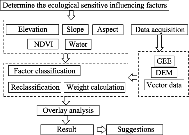
Fig. 2 Method flow chart

3 Results and analysis

3.1 Reclassification of ecologically sensitive factors

On the basis of a field investigation in the Nyingchi area, the ecological sensitivity factors in this area were evaluated. We created a database in ArcGIS 10.2, and used the resampling tool of ArcToolbox to process (Resample) and analyze each factor for reclassification.

3.1.1 Elevation sensitivity analysis

The northern part of the Nyingchi region is the Nyingchi Tanggula Mountains, the southern part belongs to the eastern part of the Himalayas, the northwestern part is the Gangdis Mountains, and the eastern part is the Hengduan Mountains (Liu, 2019). The terrain of the whole Nyingchi region is inclined from northwest to southeast. The lowest point is in Bachica, in the lower reaches of the Yarlung Zangbo River, and the highest point is in the Namjagbarwa Peak. The relative height difference can reach more than 7600 m, and the differences in elevation affect natural environmental factors such as temperature, wind and humidity. According to the field investigation in Nyingchi area, the different elevations will even affect the rainfall in Tibet during the rainy season. All these factors indirectly affect the local ecological conditions and vegetation distribution. In terms of the reclassification of elevation sensitivity, it generally showed a trend of gradual increase from south to north. The areas with high sensitivity were the most common, accounting for 29.11% of the Nyingchi region, covering an area of 34064.02 km2 and mainly distributed in the north and west of Nyingchi region (Fig. 3). The total percentage of moderate sensitivity, high sensitivity and extreme sensitivity combined is 76.72%. This high percentage is due to the overall high elevation of the Nyingchi region, so the elevation sensitivity evaluation in most areas indicates either moderately sensitive or more sensitive.
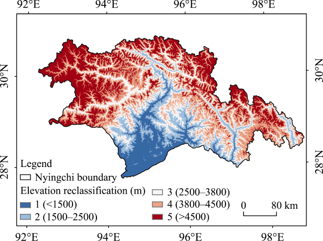
Fig. 3 Nyingchi elevation sensitivity reclassification

3.1.2 Slope sensitivity analysis

Slope affects the flow and bearing capacity of materials on the earth’s surface. Generally speaking, the greater the slope, the greater the possibility of soil erosion and damage, and the stronger the ecological sensitivity, making natural restoration more difficult. The slope sensitivity reclassification and analysis (Fig. 4) shows that the slope sensitivity of Nyingchi area is relatively low compared with other factors, because the proportions of no sensitivity, mild sensitivity and moderate sensitivity are 7.43%, 28.85% and 53.62%, respectively. The total area of these three combined is 105181.99 km2, and moderate sensitivity is the most widespread level. Extremely sensitive areas are mainly in Bomi county in the Nyingchi region and Motuo County in the central part, which is mainly affected by the mountains surrounding Nyingchi.
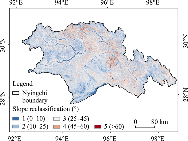
Fig. 4 Nyingchi slope sensitivity reclassification

3.1.3 NDVI sensitivity analysis

The Nyingchi region is a wide area, which results in a variety of topographical and thermal conditions. Nyingchi region has various types of vegetation belonging to tropical, subtropical and alpine cold zones, which have both horizontal and very obvious vertical distributions. Grassland is also widely distributed in Nyingchi area, with a total area of 26238.26 km2 (Ge et al., 2013), accounting for 22.91% of the total land area. According to the field investigation, the maximum upper limit of alpine meadow distribution in Nyingchi area is 5300 m, and the ice and snow line is generally around 5000 m. In addition, the original forest is densely covered, and the forest line is generally about 4200 m above sea level. The lower the vegetation coverage of an area, the higher its ecological sensitivity, because after being damaged, its self-repair ability is relatively weak, the recovery process is relatively slow, and its ecological environment will inevitably be affected to some extent. According to the analysis results (Fig. 5), the NDVI sensitivity increases from south to north. According to the actual situation, the northern and central parts of Nyingchi region pass through the Himalayan Mountains and the Northern Gangdise Mountains. Due to their higher elevations, these areas have less vegetation and lower NDVI values, while the southern areas have higher NDVI values at lower elevations. In general, NDVI sensitivity is low in Nyingchi, with 57.24% and 9.44% of the areas at levels of insensitivity and low sensitivity, respectively, and 17471.21 km2 of the area has extreme sensitivity. However, vegetation plays an important role in ecological restoration. In this study, the weight of NDVI was 0.3 when evaluating ecological sensitivity.
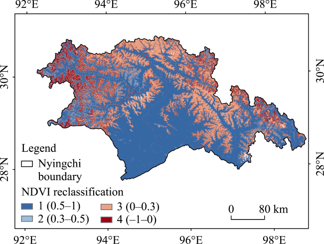
Fig. 5 NDVI sensitivity reclassification of Nyingchi

3.1.4 Aspect sensitivity analysis

Different slope orientations lead to different intensities of solar radiation and lengths of sunlight in the habitats, and the intensity of solar radiation and the duration of sunlight affect the growth of mountain vegetation. In the northern hemisphere, the southern, southeastern, eastern and southwestern slopes receive more solar radiation. Therefore, these slopes are less ecologically sensitive, while the northern slopes have the strongest ecological sensitivity. In Nyingchi area, the slope aspect sensitivity is strong (Fig. 6), and the area with moderate sensitivity or above accounts for 61.93%, covering an area of 72458.17 km2.
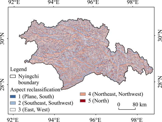
Fig. 6 Reclassification of slope aspect sensitivity in Nyingchi

3.1.5 Water sensitivity analysis

In general, the closer an area is to a water body, the higher its sensitivity, and the highest ecological sensitivity is assigned to the water body itself. Therefore, in this study, we set the factor of “water body sensitivity” by the distance to the water body in order to determine the ecological sensitivity of the Nyingchi area. The large watersheds in Nyingchi include the Yarlung Tsangpo River Basin, the Niyang River Basin, and the Palung Tsangpo Basin. In this paper, the NDVI of the Nyingchi area was calculated using Landsat8 images and then the NDVI values were used for watershed extraction. The resulting watershed surface of the Nyingchi region was then used as the basis for buffer zone analysis, and its watershed sensitivity was obtained.
As shown in Fig. 7, the ecological sensitivity caused by watershed factors in the Nyingchi area is mainly concentrated in the northern and central parts of the Nyingchi area. However, our calculation shows that the water sensitive area only accounts for 0.02% of the area, while the insensitive and more sensitive areas account for 89.43% of the area of the Nyingchi region. From this, we can see that the ecologically sensitive areas in Nyingchi region are less affected by water factors, but water resources are more important for climate regulation and ecological restoration. Therefore, we assigned a weight of 0.3 to the watershed sensitivity.
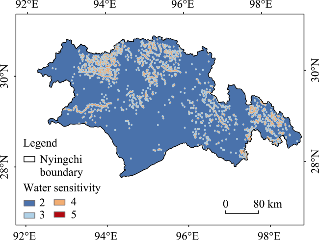
Fig. 7 Water sensitivity reclassification in Nyingchi

3.2 Grid overlay calculation of ecological sensitivity

After the reclassification of all factors through the above steps, the grid images of eco-sensitive factors with roughly the same classification grade were obtained. Then, ArcGIS was used to establish a weighted superposition model which was combined with the weights of each of the factors obtained from the AHP model in order to carry out the weighted superposition calculation. The calculation formula is:
$S_{i}=\sum^{n}_{j=1}R_{ij}W_{j}$
where Sj represents the comprehensive ecological sensitivity evaluation value of the jth grid; Rij represents the contribution value of ecological sensitivity for the ith index and the jth grid pixel; Wj is the ecological sensitivity weight value of the jth index; n is the number of grid pixels; i is the index code; and j is the grid code. Thus, the spatial distribution map of ecological sensitivity in Nyingchi region was obtained (Fig. 8).
Fig. 8 Calculation results of comprehensive ecological sensitivity in Nyingchi
It can be seen that the comprehensive index of ecological sensitivity in Nyingchi is in the range of 2.3-8.5. The strength of the sensitivity represents the ability of the ecological environment to repair itself and even the possibility of ecological problems in the area. To a certain extent, the stability of the ecological environment in the Nyingchi area can be improved by proposing reasonable strategies for the improvement of sensitive areas of different degrees. The ecological sensitivity analysis map shows the locations of different degrees of sensitivity in the Nyingchi area. Based on the summary of existing studies, we used the natural breakpoint method (Jenks) among the ArcGIS reclassification tools to classify the Nyingchi area into five levels (Fig. 9).
Fig. 9 Reclassification diagram of the ecological sensitivity calculation results
The areas and percentages of each grade (Table 4) were then obtained through statistical calculation of the classification diagram.
Table 4 Ecological sensitivity grade areas and percentages of Nyingchi
Level Percentage (%) Area (km2)
Not sensitive 54.81 64124.25
Light sensitive 11.97 14006.89
Moderate sensitive 10.34 12102.99
Highly sensitive 8.65 10122.21
Extremely sensitive 14.23 16643.65
According to the resulting diagram (Fig. 9) and statistical table (Table 4), the ecological sensitivity of the Nyingchi area is generally low, and the moderately sensitive, the highly sensitive and extremely sensitive areas are 10.34%, 8.65% and 14.23%, respectively, and their areas are 12102.99 km2, 10122.21 km2 and 16643.65 km2, respectively. These more sensitive areas are mainly distributed in Bomi County in the north, Gongbujiangda County in the east and Lang County in the southeast of Nyingchi, while the mildly sensitive areas are roughly distributed in the south of Nyingchi, mainly in Motuo County.

4 Discussion

Based on the natural environmental characteristics of Nyingchi Region in the Tibet Autonomous Region of China, supplemented by field investigation and a review of the relevant literature, this paper established an ecological sensitivity assessment system for the study area, and selected slope, aspect, elevation, NDVI and water as the ecological sensitivity assessment indexes. After reclassification and combined with the weighting of each factor obtained by analytic hierarchy Process (AHP), the ecological sensitivity of the Nyingchi region was evaluated and analyzed by using ArcGIS weighted superposition, the comprehensive evaluation and analysis diagram of ecological sensitivity of Nyingchi region was obtained, and suggestions for protection were put forward.
On the whole, the ecological environment is fragile in the highly sensitive and extremely sensitive areas. Due to the characteristics of high altitude and large slope in these areas, once an ecological damage accident occurs, the possibility of restoration will be greatly reduced. Therefore, the key ecological protection areas should be established in advance. According to the data provided by the Nyingchi Party-government website, a number of ecological reserves have been established successively in Nyingchi since 1985 (Table 5).
Table 5 Existing nature reserves in Nyingchi and their establishment years
Year Name
1985 Motuo Nature Reserve
Chayu Nature Reserve
Bo Mi Gang Xiang Nature Reserve
Nyingchi Baige Nature Reserve
1993 Nyingchi Dongkuchibok Nature Reserve
Most of these nature reserves are located in the ecologically sensitive, highly sensitive and extremely sensitive areas evaluated in this paper. Their establishment shows that the local government has begun to protect ecologically fragile areas. For moderately sensitive areas, although the ecological environment is also vulnerable to damage, moderate development can be carried out, and attention should be paid to both development and protection. In areas that are not sensitive or mildly sensitive, the ecological environment is relatively good, so they can support scientific development activities and at the same time can also open up tourist areas. This would include the Nyingchi area of Motuo county, which in the south is the lowest point of the Tibetan plateau, with the most gentle slopes, the most abundant rainfall, and the best preserved ecological place, so some tourist areas can be strategically set up to increase income.

5 Conclusions

According to the results of this study, the highly sensitive and extremely sensitive areas accounted for 8.65% and 14.23%, respectively, while the areas that are not sensitive and light sensitive accounted for 66.78% combined, indicating that the ecological sensitivity of the Nyingchi area as a whole was relatively low. According to the actual situation and relevant literature at home and abroad, the factors of elevation, slope, aspect, normalized vegetation index and water area were selected. Altitude determines the temperature and humidity in this area. In the actual investigation, we found that the forest line on the mountain in Nyingchi area was very obvious, and the growth of many plants was limited by altitude. When the slope increases, the growth of vegetation on the slope is also affected, so it is difficult to repair and protect the damaged vegetation. Different vegetation coverage levels determine the soil and water conservation capacity of this region, which plays a decisive role in the growth and development of organisms in this region. As can be seen from the NDVI of Nyingzhi region, it increases from south to north on the whole, and the ecological sensitivity in the east is lower than that in the west.
In 2021, the Chinese government solemnly declared that it had won the important battle of poverty alleviation, and that the ecological environment is an important prerequisite for sustainable development. Therefore, while developing the local economy, we should adhere to the important concept of both protection and development, and also adhere to the important concept that “Clear waters and green mountains are as good as mountains of gold and silver.”
[1]
Chen G Y, Pu B, Ci R, et al. 2019. Early warning of mountain flood geological disasters in Nyingchi based on logistic regression method. Chinese Agricultural Science Bulletin, 35(23): 124-130. (in Chinese)

[2]
Chen Y Y, Luo Z J, Qi S, et al. 2021. Ecological security pattern construction of Nanchang City based on ecological sensitivity and ecological network. Research of Soil and Water Conservation, 28(4): 342-349. (in Chinese)

[3]
Cui N, Yu E Y, Li S, et al. 2021. Protection measures of plateau lake based on ecosystem sensitivity and importance of ecosystem function: The case of Lake Dalinor Basin. Acta Ecologica Sinica, 41(3): 949-958. (in Chinese)

[4]
Deng X, Li J M, Zeng H J, et al. 2012. Research on computation methods of AHP wight vector and its applications. Mathematics in Practice and Theory, 42(7): 93-100. (in Chinese)

[5]
Duan L J, Duan A M, Hu W T, et al. 2017. Low frequency oscillation of precipitation and daily variation characteristic of air-land process at Shiquanhe Station and Nyingchi Station in Tibetan Plateau in the summer of 2014. Chinese Journal of Atmospheric Sciences, 41(4): 767-783. (in Chinese)

[6]
Eggermont H, Verschuren D, Audenaert L, et al. 2010. Limnological and ecological sensitivity of Rwenzori Mountain Lakes to climate warming. Hydrobiologia, 648(1): 123-142.

DOI

[7]
Gan L, Chen Y B, Wu Z F, et al. 2018. The variation of ecological sensitivity in Guangdong-Hong Kong-Macao Greater Bay Area in recent 20 years. Chinese Journal of Ecology, 37(8): 2453-2462. (in Chinese)

[8]
Garrod G D, Willis K G. 1999. Methodological issues in valuing the benefits of environmentally sensitive areas. Journal of Rural Studies, 15(1): 111-117.

DOI

[9]
Ge L W, Pan G, Ren D Z, et al. 2013. Forest carbon storage, carbon density, and their distribution characteristics in Nyingchi area of Tibet, China. Chinese Journal of Applied Ecology, 24(2): 319-325. (in Chinese)

[10]
Guo C B, Wu R A, Jiang L W, et al. 2021. Typical geohazards and engineering geological problems along the Ya’an-Nyingchi section of the Sichuan-Tibet Railway, China. Geoscience, 35(1): 1-17. (in Chinese)

[11]
Jiang X, Zhou X, Xiao Y, et al. 2021. Ecological space zoning based on lake ecosystem health maintenance: Taking the Hongfeng Lake Basin as example. Acta Ecologica Sinica, 41(7): 2571-2581. (in Chinese)

[12]
Liu H L, Wang W Q, Wang Y F, et al. 2021a. Comprehensive evaluation of ecological sensitivity and the characteristics of spatiotemporal variations in Fenhe River Basin. Acta Ecologica Sinica, 41(10): 3952-3964. (in Chinese)

[13]
Liu J H, Gao J X, Ma S, et al. 2015. Evaluation of ecological sensitivity in China. Journal of Natural Resources, 30(10): 1607-1616. (in Chinese)

[14]
Liu J P, Ren Q, Xu Y Y, et al. 2021b. Evaluation on ecological sensitivity of the agricultural region in the central part of Jilin Province. Journal of Jilin Normal University (Natural Science), 42(3): 115-121. (in Chinese)

[15]
Liu X. 2019. Risk assessment of geological hazards in the central area of Nyingchi based on remote sensing and GIS. Diss., Dalian, China: Liaoning Normal University.

[16]
Ouyang Z Y, Wang X K, Miao H. 2000. China’s eco-environmental sensitivity and its spatial heterogeneity. Acta Ecologica Sinica, 20(1): 10-13. (in Chinese)

[17]
Saaty T L. 2004. Decision making—The analytic hierarchy and network processES (AHP/ANP). Journal of Systems Science and Systems Engineering, (1): 1-35.

[18]
Sutherland W J, Broad S, Butchart S H M, et al. 2019. A horizon scan of emerging issues for global conservation in 2019. Trends in Ecology & Evolution, 34(1): 83-94.

DOI

[19]
Tang J, Rong Y J, Du S X. 2017. Evaluation of eco-environmental sensitivity in North Shanxi Province. Environment and Sustainable Development, 42(4): 204-206. (in Chinese)

[20]
Ventura D, Bonifazi A, Gravina M F, et al. 2018. Mapping and classification of ecologically sensitive marine habitats using unmanned aerial vehicle (UAV) imagery and object-based image analysis (OBIA). Remote Sensing, 10(9): 1331. DOI: 10.3390/rs10091331.

DOI

[21]
Wei M Y. 2018. Study on forest vegetation distribution and dynamic change monitoring in Nyingchi area. Diss., Xi’an, China: Chang’an University. (in Chinese)

[22]
Yang F, Li C B, Wu J, et al. 2020. Research on ecological spatial distribution and conservation direction based on the analysis of ecosystem service function importance and ecological sensitivity. Territory & Natural Resources Study, (5): 19-25. (in Chinese)

[23]
Zhang W Y, Sun W J, Zhang Y L. 2018. Wavelet analysis and Mann-Kendall test of mean air temperature and annual precipitation in Nyingchi, Tibet, China from 1960 to 2012. Journal of Desert Research, 38(5): 1086-1092. (in Chinese)

[24]
Zhou X Y, Cai J, Zhang W W. 2021. Ecological sensitivity evaluation of national ecological county based on GIS: Take Huoshan County of Anhui as an example. Journal of Yunnan Agricultural University (Social Sciences), 15(4): 148-155. (in Chinese)

[25]
Zhou Y L, Yang Y F, Yuan W Y, et al. 2016. Analysis and evaluation on ecological sensitivity of Xiaoqinghe River Basin in Jinan based on GIS. Journal of Northwest Forestry University, 31(3): 50-56. (in Chinese)

Outlines

/