Ecosystem Assessment

Comparison of the Application of Different Process-based Models in the Study of Spatio-temporal Patterns of Ecosystem Service Value

  • GUO Xuan , 1, 2, 3 ,
  • GUO Qun 1, 3, 4 ,
  • LI Yu 4, 5 ,
  • LI Shenggong , 1, 3, 4, *
Expand
  • 1. Key Lab of Ecosystem Network Observation and Modeling, Institute of Geographic Sciences and Natural Resources Research, Chinese Academy of Sciences, Beijing 100101, China
  • 2. Sino-Danish College, University of Chinese Academy of Sciences, Beijing 100190, China
  • 3. National Ecosystem Science Data Center, Beijing 100101, China
  • 4. College of Resources and Environment, University of Chinese Academy of Sciences, Beijing 100190, China
  • 5. Key Lab for Resources Use and Environmental Remediation, Institute of Geographic Sciences and Natural Resources Research, Chinese Academy of Sciences, Beijing 100101, China
*LI Shenggong, E-mail:

GUO Xuan, E-mail:

Received date: 2021-04-10

  Accepted date: 2022-05-09

  Online published: 2023-01-31

Supported by

The Strategic Priority Research Program of the Chinese Academy of Sciences(XDA23060205)

The National Natural Science Foundation of China(31961143022)

The National Natural Science Foundation of China(32161143029)

Abstract

Quantitative assessments of ecosystem service value (ESV) are of great significance for rational allocation of environmental resources and making regional ecological protection decisions. The method of equivalence factor per unit area is widely used for this purpose because of its simple algorithm. However, ESV is also affected by biotic and environmental factors (e.g., net ecosystem productivity (NEP) or precipitation), which are difficult to obtain at the regional scale, leading to uncertainty in ESV estimations. In this study, according to the equivalent factor modified by precipitation and NEP from four state-of-the-art process-based productivity models, i.e., CLM4.0, LPJDGVM, LPJGUESS and ORCHIDEE, we explored the temporal and spatial patterns of ESV of 15 administrative regions in northern China. The results show that the simulation accuracy of different models varied among four representative ecosystem types, i.e., typical steppe in northern China, alpine steppe in northwest China, farmland ecosystem in central China, and forest in northeast China, implying that model-based ESV estimates are ecosystem-specific. The ESV tends to decline from northeast to southwest in northern China. Regions with dense vegetation usually had high ESV due to better hydrological and thermal conditions. Low vegetation coverage areas, such as Qinghai and Xinjiang, had higher ESV because of their large geographical areas. The central and eastern developed regions without abundant natural resources had lower ESV due to their lower NEP. For different categories of ecosystem services, the regulation services (mainly water flow regulation services and climate regulation services) contributed the most to ESV. For the temporal dynamics, the total ESV of the 15 provinces, autonomous regions and municipalities showed an insignificant downward trend over the years. The regions with increasing trends of ESV were distributed in northwestern China, while pixels with decreasing trends of ESV were concentrated in northeastern China. Land use cover change may be the most important factor controlling the temporal dynamics of ESV. Our results can provide support for the enaction of reasonable strategies for ecological protection and economic development in northern China.

Cite this article

GUO Xuan , GUO Qun , LI Yu , LI Shenggong . Comparison of the Application of Different Process-based Models in the Study of Spatio-temporal Patterns of Ecosystem Service Value[J]. Journal of Resources and Ecology, 2023 , 14(1) : 147 -157 . DOI: 10.5814/j.issn.1674-764x.2023.01.014

1 Introduction

Ecosystems provide a variety of ecological products and services which maintain environmental conditions or provide materials that sustain human beings, other animals, and plants (Zhang et al., 2010). The continuous development of industrialization and urbanization has considerably affected ecosystems. Therefore, quantitative assessments of ecosystem service value (ESV) and ecosystem asset management are of great significance for the rational allocation of natural resources and guiding regional ecological protection decisions (Watson et al., 2020). Generally, two kinds of approaches are widely utilized for ESV estimation. One approach is based on the primary economic value of ecosystem service functions (Zhao et al., 2004; Wang et al., 2007), and is usually applied at small spatial scales or in individual ecosystems due to its requirements of many input parameters and complex ecological processes. Another approach is based on the equivalence factor of ESV per unit area, which has been widely used due to its advantages of using fewer parameters and simplicity (Costanza et al., 1997; Xie et al., 2008; Mu, 2016; Xie et al., 2017).
The equivalent factor method developed by Xie et al. (2003) is based on a survey from 500 Chinese ecological experts, and has been widely used at site, regional, and national scales (Zhao et al., 2011; Wang et al., 2014). However, many recent studies have realized that the ecosystem equivalence factors are regulated by a wide range of biotic and environmental factors, such as productivity, precipitation, soil and vegetation conditions. Of particular importance, productivity and precipitation have greater influences on equivalence factors (Mu, 2016). In addition, due to the relative difficulty of acquiring regional data, many previous studies did not take these factors into consideration in their ESV estimations at the pixel scale.
As an essential approach for productivity estimation, process-based productivity models are widely used in ecosystem studies, in which net ecosystem productivity (NEP) (the difference between gross ecosystem productivity (GEP) and ecosystem respiration (RE)) is the main part of organic carbon (or net primary productivity (NPP)) accumulated through plant growth. However, it should be noted that NEP is restricted by the atmospheric CO2 concentration, species composition, climatic conditions, soil nutrients and many other factors. Simulated NEP values from different models have shown obvious variations due to the complex calculation processes and various input parameters. For example, simulated NEP in northeast China vary by about 0.5-fold (Wang, 2004; Li et al., 2014), and the average NPP of Chinese terrestrial ecosystems vary depending on the process and remote sensing models (Gao et al., 2012). Therefore, several models should be applied to obtain the best simulation results after an applicability analysis and comparison among the different models in various regions.
As a region with many fragile areas, northern China covers a wide range of vegetation types, e.g., forest, steppe, and desert, etc., and it also includes various economic development states. In view of the limitations of the ESV evaluation discussed above, we collected precipitation data and NEP taken from different process-based productivity models to modify the equivalence factor coefficients. Using these data, we aimed to: 1) Analyze the spatio-temporal pattern of ESV in northern China from 1982-2010; and 2) Obtain the best simulation results of ESV in each region based on an applicability analysis of different models.

2 Materials and methods

2.1 Study region

The study region covers the northeastern economic zone, the northern coastal economic zone, the middle reaches of the Yellow River and the northwestern economic zone, including 10 provinces (Hebei, Shandong, Heilongjiang, Jilin, Liaoning, Shanxi, Shaanxi, Henan, Gansu, Qinghai), three autonomous regions (Inner Mongolia, Ningxia, Xinjiang), and two province-level municipalities (Beijing, Tianjin). These zones differ at the provincial level in their stages of economic development, manufacturing activities (light industry vs. heavy industry), and the status of available ecological resources (abundant vs. insufficient).

2.2 Data sources

Precipitation data from 756 national meteorological stations in China were acquired from the China Meteorological Data Service Center website (http://data.cma.cn/en). The site-level data were interpolated with the ANUSPLIN software package, which provides an interpolation of noisy multi-variate data using the thin plate smoothing splines from the meteorology station observation data. The quality of the interpolated meteorological dataset has been fully evaluated (error rate less than 7%) (Yu et al., 2004).
Land use data from 1980 to 2010 (in the years of 1980, 1990, 1995, 2000, 2005 and 2010) were derived from Landsat TM/ETM remote sensing images and were generated by manual visual interpretation. The ecosystems were divided into five primary types of farmland, forest, grassland, water body, and desert. The datasets can be found at the Resource and Environmental Science Data Center of the Chinese Academy of Sciences (http://www.resdc.cn). ESV in the periods of 1982-1989, 1990-1994, 1995-1999, 2000-2004, 2005-2009, and 2010 were calculated based on land use data in the years of 1980, 1990, 1995, 2000, 2005 and 2010, respectively.
Productivity data in this study were from Community Land Model (CLM4.0), Lund-Potsdam-Jena Dynamic Global Vegetation Model (LPJDGVM), Lund-Potsdam- Jena General Ecosystem Simulator (LPJGUESS), and Organizing Carbon and Hydrology in Dynamic Ecosystems Land Surface Model (ORCHIDEE). The input climate data came from CRU- NCEP (http://dods.extra.cea.fr/data/p529viov/cruncep/). The spatial and temporal resolutions of the process-based productivity model data are 0.5 degrees and 30 days, respectively. The spatial resolution of the ESV results was the same as that of the process-based productivity model data.
CLM4.0 is currently one of the most well-developed land surface process models in the world, which is also the land model for the Common Earth System Model (CESM) and the Common Atmosphere Model (CAM). The surface module has been coupled with multiple climate models, mainly including four parts: biogeophysics, hydrological cycle, biogeochemistry, and dynamic vegetation (Lai et al., 2014). LPJDGVM is a coupled dynamic biogeographic earth model that combines process-based terrestrial vegetation dynamics, terrestrial atmospheric carbon and a water exchange framework, and takes some key ecosystem processes into account, such as photosynthesis, carbon allocation, mortality, resource competition, fire disturbance, and soil heterotrophic respiration (Sitch et al., 2003). LPJGUESS simulates the vegetation dynamics and the mass and energy exchanges between the biosphere and the atmosphere. Based on climatic input data, it provides vegetation-related information such as vegetation types and leaf area indexes for climate systems and land surface programs (Smith et al., 2001; Tang et al., 2014). ORCHIDEE calculates the exchange fluxes of carbon dioxide, water and heat with the atmosphere at an hourly scale, and the daily changes of water and carbon sinks. The model is constructed as two coupled modules. The first module describes the energy and moisture exchange between the atmosphere and the vegetation canopy in a 30-minute time step. The second module simulates the terrestrial carbon cycle, including photosynthesis, respiration, carbon distribution, litter decomposition, and phenology at daily time steps (Krinner et al., 2005; Piao et al., 2006; Tan et al., 2010). These models have been widely used to investigate regional and global terrestrial vegetation growth (Mao et al., 2013; Poulter et al., 2013), and extensively validated against observations across different ecosystems and regions, including China (Piao et al., 2006; Tan et al., 2010; Tao et al., 2010; Piao et al., 2013).
The eddy covariance flux approach based on the theory of micrometeorology enables the direct measurements of functions and processes at the ecosystem scale, such as NEP, energy balance, and greenhouse gas exchange, with a spatial resolution of about 100-3000 m and higher temporal resolution (Baldocchi, 2003). According to the geographical location and ecosystem type, the study region was divided into the typical steppe in northern China, alpine steppe in northwest China, farmland ecosystem in central China, and forest in northeast China. We have obtained eddy covariance flux-based NEP records from ChinaFLUX of four sites representing these four ecosystems from 2003 to 2008. The sites are the alpine grassland ecosystem in Qinghai, the forest ecosystem in Changbai Mountain in Jilin, the temperate typical steppe ecosystem in Inner Mongolia, and the Yucheng farmland ecosystem in Shandong. According to the positions of the eddy covariance flux observation stations, we extracted the simulated NEP data from the process-based productivity model to measure the ratio with the actual NEP data from the eddy covariance fluxes. The closer the ratio is to 1, the better the simulation effect of the model.

2.3 Data analysis

Based on the equivalence coefficient table developed by Xie et al. (Xie et al., 2003, 2015), the equivalent factor method (Table 1) was applied to estimate the ESV for farmland, forest, grassland, desert, and water body ecosystems in northern China.
Table 1 Equivalence coefficients of different types of ecosystem services
Primary classification Secondary classification Farmland Forest Grassland Desert Water body
Provisioning services Food supply 1.11 0.25 0.23 0.01 0.80
Raw material supply 0.25 0.58 0.34 0.03 0.23
Water supply -1.31 0.30 0.19 0.02 8.29
Regulating services Air quality regulation 0.89 1.91 1.21 0.11 0.77
Climatic regulation 0.47 5.71 3.19 0.1 2.29
Waste treatment 0.14 1.67 1.05 0.31 5.55
Regulation of water flows 1.50 3.74 2.34 0.21 102.24
Supporting services Erosion prevention 0.52 2.32 1.47 0.13 0.93
Maintenance of soil fertility 0.16 0.18 0.11 0.01 0.07
Habitat services 0.17 2.12 1.34 0.12 2.55
Cultural services Cultural & amenity services 0.08 0.93 0.59 0.05 1.89

Note: Adopted from the Millennium Ecosystem Assessment report (MA) and Xie et al. (2015). Negative value means the land use type does not provide the corresponding service value, and needs to use the resources.

Ecosystem services were divided into 11 categories according to a similar classification system from Xie et al. (2015). A positive correlation generally exists between productivity and service of ecosystem food production, raw material production, air quality regulation, climate regulation, waste treatment, maintenance of soil fertility, habitat services, and cultural functions. Similarly, water supply, regulation of water flows, and erosion prevention have proven to be closely related to precipitation (Li, 2010; Pei, 2013; Xie et al., 2015; Mu, 2016). It should be noted that erosion prevention is also influenced by soil and slope, but we just consider rainfall as the main factor in this paper. Therefore, based on the above-mentioned information and spatial-temporal productivity and precipitation data, we used the following formula to further modify the unit value of ecosystem services dynamically:
Qi=(b/BPi
where Qi refers to modified ESV per unit area; Pi is standard ESV per unit area, which is calculated from the equivalent coefficients of ecosystem services and standard equivalence factor that is defined as the economic value of natural grain output per unit area of farmland (Xie et al., 2017), i = 1, 2, …, 11, represents the 11 categories ecosystem services; b refers to the productivity or precipitation on a pixel scale, and B is the average productivity or precipitation of the study region. When i refers to food supply, raw material supply, air quality regulation, climatic regulation, waste treatment, maintenance of soil fertility, habitat services or cultural services, b and B refer to productivity in this calculation. When i refers to water supply, regulation of water flows or erosion prevention, b and B refer to precipitation in this calculation. Data processing and statistical analyses were performed using ArcGIS 10.2 and MATLAB 14.0, respectively. Figures were drawn using ArcGIS 10.2 and OriginPro 2018.

3 Results

3.1 Comparison between simulated NEP and observed NEP

The comparison of NEP values from process-based productivity models and the eddy covariance approach showed that the LPJDGVM model has best performance for the NEP simulation, with the ratios of simulated NEP and observed NEP between 0.94-2.85. CLM4.0 showed higher simulation precision in the Yucheng farmland ecosystem, and LPJDGVM has NEP values closest to the NEP from the eddy covariance approach in the Changbai Mountain forest ecosystem, Inner Mongolia typical steppe and Haibei alpine grassland ecosystem (Table 2).
Table 2 Ratios of the modeled net ecosystem productivity (NEP) from CLM4.0, LPJDGVM, LPJGUESS, and ORCHIDEE to the net ecosystem productivity (NEP) measured with the eddy covariance technique
Site Latitude Longitude Year $\frac{CLM4.0}{Flux}$ $\frac{LPJDGVM}{Flux}$ $\frac{LPJGUESS}{Flux}$ $\frac{ORCHIDEE}{Flux}$
Yucheng farmland 36.83°N 116.57°E 2003-2008 1.12 1.56 1.79 4.39
Haibei alpine meadow 37.67°N 101.33°E 2003-2008 2.70 1.51 2.43 2.07
Changbai Mountain forest 42.40°N 128.09°E 2003-2008 3.90 2.85 3.09 3.76
Inner Mongolia grassland 44.53°N 116.67°E 2004-2008 2.31 0.94 3.36 2.17

3.2 ESV per unit area modified by precipitation and simulated NEP

The total ESV per unit area, which was modified by precipitation and NEP, showed obvious variations among models and regions. At the provincial scale, Jilin, Heilongjiang, Liaoning, Shaanxi, and Beijing had the highest ESV per unit area, while Gansu, Qinghai, Xinjiang and Ningxia had relatively low ESV per unit area.
Figure 1 shows the spatial pattern of ESV per unit area of the different provinces. Generally, ESV decreased from northeast to southwest. The total ESV per unit area modified by the CLM4.0 model and precipitation ranged from 17069 yuan ha-1 (Ningxia) to 114568 yuan ha-1 (Heilongjiang), with an average value of 60159 yuan ha-1 (Fig. 1a). The lowest and highest total ESV per unit area modified by the LPJDGVM model were in Xinjiang (10811 yuan ha-1) and Heilongjiang (113257 yuan ha-1), respectively (Fig. 1b). For total ESV per unit area modified by the LPJGUESS model (Fig. 1c), the lowest value of 14487 yuan ha-1 was in Xinjiang, which is the same as the simulated result from LPJDGVM, while Tianjin had the highest ESV per unit area (91133 yuan ha-1). Finally, the total ESV per unit area modified by the ORCHIDEE model was highest in Liaoning province (103981 yuan ha-1), and lowest in Xinjiang (14058 yuan ha-1), with an average value of 62978 yuan ha-1 (Fig. 1d).
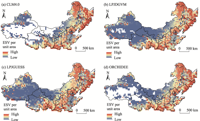
Fig. 1 The ecosystem service value (ESV) per unit area modified by precipitation and net ecosystem productivity (NEP) obtained from four models: CLM4.0 (a), LPJDGVM (b), LPJGUESS (c), and ORCHIDEE (d)
According to the simulation precision of NEP, the LPJDGVM, LPJDGVM, LPJDGVM and CLM4.0 models were selected as the benchmark models for typical steppe in northern China, alpine steppe in northwest China, forest in northeast China, and farmland ecosystem in central China, respectively. The comparisons show that in different ecosystems, ESV per unit area based on the benchmark model was generally lower than those modified by the other models (Table 3).
Table 3 The total ecosystem service value (ESV) per unit area for each of the 15 provinces, autonomous regions and municipalities in northern China modified by precipitation and net ecosystem productivity (NEP) values using four process-based models (Unit: 104 yuan ha-1)
Province CLM4.0 LPJDGVM LPJGUESS ORCHIDEE
Heilongjiang 11.46 11.33 8.49 9.55
Xinjiang 1.73 1.08 1.45 1.41
Shanxi 4.16 6.28 6.53 5.64
Ningxia 1.71 2.30 3.52 2.02
Shandong 5.59 6.22 5.51 6.90
Henan 7.00 7.38 6.35 8.45
Jilin 11.55 11.23 8.73 10.30
Liaoning 9.63 10.55 8.45 10.40
Tianjin 8.66 9.62 9.11 9.72
Qinghai 3.56 3.44 3.58 3.44
Gansu 3.72 3.46 3.54 3.07
Shaanxi 7.45 8.47 6.90 7.86
Inner Mongolia 4.03 3.68 3.95 3.37
Hebei 4.12 5.44 5.30 5.25
Beijing 5.87 7.95 7.58 7.09

3.3 Total ESV modified by precipitation and simulated NEP

The total ESV for 11 categories of ecosystem services showed obvious spatial variations, with higher values from the northeast (i.e. Jilin, Heilongjiang, Qinghai, Inner Mongolia, Shaanxi, and Xinjiang) and the lowest values in central and western provinces (e.g. Beijing, Tianjin, Hebei, Shandong, Shanxi, Ningxia). Specifically, Heilongjiang (CLM4.0: 5.13×10¹² yuan, LPJDGVM: 5.07×10¹² yuan, ORCHIDEE: 4.28×10¹² yuan) and Inner Mongolia (LPJGUESS: 4.5×10¹² yuan) had the highest total ESV, while Ningxia (CLM4.0: 0.08×10¹² yuan, ORCHIDEE: 0.1×10¹² yuan) and Tianjin (LPJGUESS: 0.10×10¹² yuan, LPJDGVM: 0.11×10¹² yuan) had the lowest total ESV (Table 4).
Table 4 The total ecosystem service value (ESV) for each of the 15 provinces, autonomous regions and municipalities modified by precipitation and net ecosystem productivity (NEP) values of the four process-based models (Unit: 1012 yuan)
Province CLM4.0 LPJDGVM LPJGUESS ORCHIDEE Average
Heilongjiang 5.13 5.07 3.80 4.28 4.57
Xinjiang 1.16 1.63 2.32 1.27 1.59
Shanxi 0.65 0.99 1.03 0.88 0.89
Ningxia 0.08 0.12 0.18 0.10 0.12
Shandong 0.84 0.93 0.82 1.03 0.91
Henan 1.15 1.22 1.05 1.39 1.20
Jilin 2.20 2.14 1.67 1.96 1.99
Liaoning 1.35 1.48 1.19 1.46 1.37
Tianjin 0.10 0.11 0.10 0.11 0.10
Qinghai 1.67 2.40 2.39 1.87 2.08
Gansu 0.98 1.40 1.43 1.16 1.24
Shaanxi 1.53 1.74 1.42 1.62 1.58
Inner Mongolia 3.56 4.20 4.50 3.72 4.00
Hebei 0.76 1.00 0.98 0.94 0.92
Beijing 0.10 0.13 0.12 0.12 0.12
Among different productivity models, LPJGUESS and LPJDGVM generally yielded higher total ESV than CLM4.0 and ORCHIDEE, while LPJDGVM and CLM4.0 presented greater ESV ranges than the other models. In order to comprehensively assess the results of all models, we calculated the averaged ESV of the four models in each province. The averaged ESV of each study region show that there is a similar spatial pattern, with higher ESV distributed in northern China, and lower ESV in some western provinces. Heilongjiang (4.57×10¹² yuan) and Inner Mongolia (4×10¹² yuan) had the highest ESV, followed by Qinghai (2.08×10¹² yuan), Jilin (1.99×10¹² yuan), and Shaanxi (1.58×10¹² yuan). Beijing (0.12×10¹² yuan), Ningxia (0.12× 10¹² yuan), and Tianjin (0.1×10¹² yuan) had the lowest ESV.
For different ecosystem services, the regulation services accounted for the highest component (approximately 70%) of the total ESV in all regions, followed by the supporting services (around 20%), while the provisioning services and cultural services were relatively less important (Fig. 2).
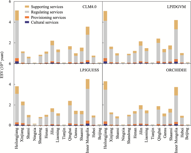
Fig. 2 The total ecosystem service value (ESV) of the four main service types in each of the 15 provinces, autonomous regions and municipalities

3.4 Temporal dynamics of total ESV from 1982 to 2010

Over the past 30 years, total ESV of the 15 provinces, autonomous regions and municipalities showed an insignificant downward trend. In particular, it fluctuated little before 1999, declined sharply in 2003, and then increased gradually to 2010. The results simulated from LPJGUESS and LPJDGVM are relatively higher than those from CLM4.0 and ORCHIDEE (Fig. 3). To assess the spatial pattern of the ESV interannual trend, we conducted a trend analysis of ESV on the pixel scale. It is obvious that the regions with increasing trends of ESV were distributed in northwestern China (Xinjiang, Qinghai, Gansu, and the northeastern part of Heilongjiang), while pixels with decreasing trends of ESV were concentrated in northeastern China (large parts of Inner Mongolia, Jilin, Liaoning, Ningxia) (Fig. 4).
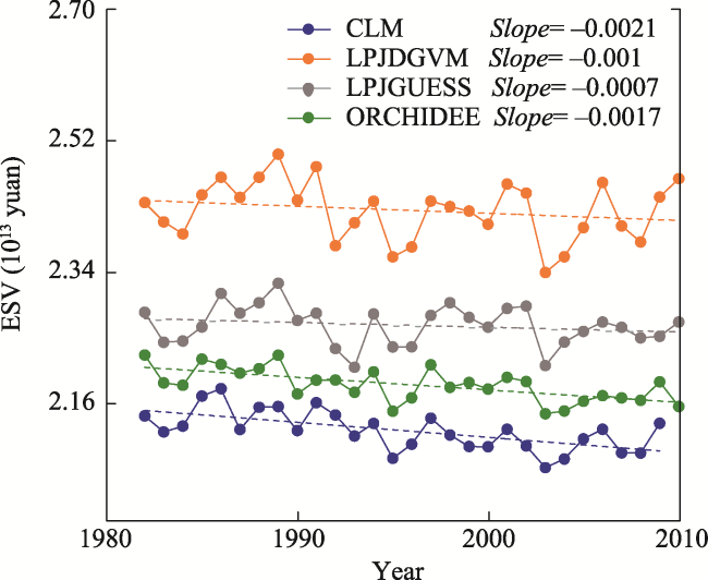
Fig. 3 The temporal dynamics of ecosystem service value (ESV) modified by precipitation and net ecosystem productivity (NEP)
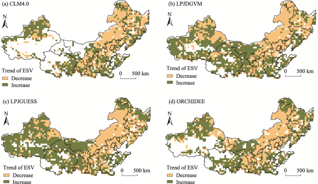
Fig. 4 Spatial distributions of the trend in ecosystem service value (ESV) calculated by ecosystem service value (ESV) per unit modified by precipitation and net ecosystem productivity (NEP) obtained from the models CLM4.0 (a), LPJDGVM (b), LPJGUESS (c), and ORCHIDEE (d)
Furthermore, in order to determine the driving forces of temporal dynamics in ESV, trend analyses of NEP, precipitation, and land use cover change were conducted. Precipitation and NEP derived from different productivity-based models showed little fluctuation (Fig. 5), while land cover changed a lot, such as the areas of forest and grassland which decreased by about 0.1×10⁵ km2 and 0.6×10⁵ km2, respectively (Fig. 6).
Fig. 5 Temporal dynamics of net ecosystem productivity (NEP) and precipitation from 1982 to 2010
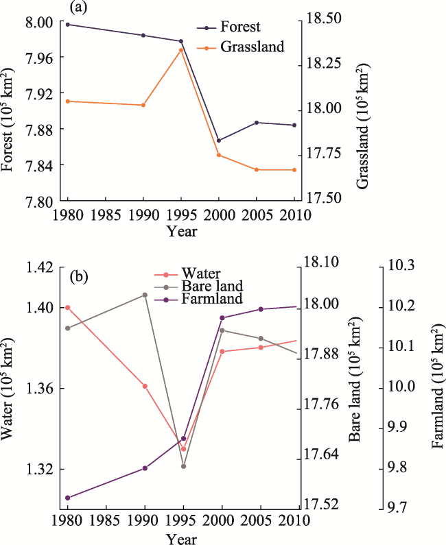
Fig. 6 Temporal dynamics of Land use cover changes from 1980 to 2010

4 Discussion

Based on the equivalent factor method, in which ESV per unit area in four primary categories and 11 secondary categories of ecosystem services were modified by four process-based productivity models and precipitation data, we evaluated the spatial and temporal patterns in ESV of 15 provinces, autonomous regions and municipalities in northern China from 1982 to 2010.

4.1 The comparison of simulated results among process-based models

The total ESV, ESV per unit area, and temporal dynamics of ESV modified by the four productivity models presented similar spatial and temporal patterns. For example, ESV gradually decreased from east to west, and the consistency of the inter-annual trend of ESV modified by NEP from the four models was relatively high. However, there are still some differences in the numerical simulation results of different models. NEP simulated by CLM4.0 and LPJDGVM are lower than those of LPJGUESS and ORCHIDEE, which suggests that although different productivity-based models incorporate the dynamics of terrestrial vegetation and atmospheric carbon-water (e.g., photosynthesis, carbon allocation, water, and heat exchange flux), the different models focused on different simulation processes. Furthermore, the process-based productivity model that has the value closest to the measured NEP was deemed as the benchmark model for each region. Generally, the ESV from the benchmark model (LPJDGVM) was higher than those in the other models in typical steppe in northern China, alpine steppe in northwest China, and forest in northeast China, while modified ESV of the farmland ecosystem in central China from the benchmark model (CLM4.0) was lower than those from the other models. The desert steppe is located in the ecologically fragile area of China, with less precipitation and lower productivity. The model parameters are difficult to quantify, leading to some deviations in the results. In addition, the lack of data sources for the CLM4.0 and ORCHIDEE models in the desert steppe in northwest China may also be an important reason for the ESV variations among models.

4.2 Spatial and temporal dynamics of ESV

The ESV evaluated by equivalence factor coefficients, which were modified by the CLM4.0, LPJDGVM, LPJGUESS and ORCHIDEE models, displayed similar spatial patterns: the provinces in northern China (e.g., Jilin, Heilongjiang, Qinghai, Inner Mongolia, Shaanxi, and Xinjiang) had higher ESV, while the other provinces in the central area (e.g., Beijing, Tianjin, Hebei, Shandong, Shanxi, and Ningxia) had relatively low ESV. This is consistent with previous studies (Shi et al., 2012; Xie et al., 2017). Possible driving forces for these spatial patterns are the complex interactions among ecosystems, climate change, and human activities. Provinces in northern China usually had the highest ESV, which is consistent with the spatial distribution of vegetation and regional ecological restoration measures, leading to a higher level of NEP. Some studies have mentioned that the greatest contribution to the total ESV in China comes from the forest ecosystem, which also proves the above view (Xie et al., 2017). At the same time, Qinghai and Xinjiang had low NEP because these provinces receive less influence from the East Asian monsoon climate and hence vegetation growth is strongly restricted. However, the vast geographic land of these two regions resulted in a higher level of ESV. In addition, the more developed provinces and municipalities (e.g., Beijing, Tianjin, Hebei, Shandong, and Shanxi) were usually characterized by lower ESV. This probably resulted from the relatively scare vegetation resources and higher proportions of construction land for heavy industries and human demands. Increasing construction land indicates a higher rate of urbanization to a certain extent, which serves as a significant constraint on the ecosystem services (Liu et al., 2021c). This also supports the view of Xie et al. (2017) that there is a negative correlation between ESV per capita and GDP per capita. In summary, the study area can be divided into three types: the type with dense vegetation and high ESV, which emphasizes the important role of vegetation under better hydrological and thermal conditions; the type which has low vegetation coverage and higher ESV but mainly due to vast geographic area; and the type of an economically developed area with the lowest NEP and lowest ESV due to scarce natural resources.
For different categories of ecosystem services, the regulation services provided the highest ESV, mainly including the water flow regulation services and climate regulation services, which were determined by the total area of the vegetation and the equivalence coefficients of different services in these provinces. Generally, the ESV of several provinces with abundant vegetation resources originated from climate regulation, because climate regulation services are the most important services of forest and grassland. Meanwhile, it should be noted that climate regulation services also contributed more to the ESV of Xinjiang, although the land cover of desert was larger than farmland and forest. This situation probably resulted from the fact that the equivalence coefficient of climate regulation services due to vegetation was higher than that of waste treatment from the desert.
The total ESV of the 15 provinces, autonomous regions and municipalities showed an insignificant downward trend with year. The regions with increasing trends in ESV were concentrated in Heilongjiang, Qinghai, and Gansu, while the economically developed parts in this region, such as Beijing, Hebei, Inner Mongolia, Jilin and Liaoning, experienced decreasing trends of ESV, which is consistent with previous findings (Shi et al., 2012; Lou et al., 2019; Liu et al., 2021a; Liu et al., 2021b; Yang et al., 2022). Land use and land cover (LULC) changes significantly affect regional ESV through obvious variations in ecosystem types and distribution patterns (Lou et al., 2019; Chen and Liu, 2021), which also can explain the insignificant decrease of ESV in our study area. For example, Yan and Zhang (2019) analyzed the impact of land cover change on ESV in the Sanjiang Plain of Heilongjiang in the past 60 years and found that as a result of human activities, a large part of the wetlands had been converted into farmland, leading to a decreasing ESV. We found that the area of forest and grassland in the 15 provinces, autonomous regions and municipalities in northern China decreased insignificantly in the past 20 years, which is consistent with previous studies. For example, grassland degradation was quite severe in the agro-pastoral ecotone of northern China as a result of the considerable substitution of grassland by construction land and barren land; and the area change of construction land (increased) and grassland (decreased) in the Beijing-Tianjin-Hebei region was the largest among the land types (Lou et al., 2019). Therefore, the irrational use of forest and grassland resources and expansion of urban construction land are likely the main driving forces for the insignificant downward trend of ESV.
Since 2000, the Chinese government has carried out ecological management and restoration projects, i.e. The Grain to Green Program (GTGP), North Shelter Forest, and The Natural Forest Protection Project, with an aim of increasing the vegetation coverage and mitigating soil erosion. These restorations have achieved major project results (Lu et al., 2018), such as an increased ESV in Ansai District during 1980-2018 (Han et al., 2021). Compared with the decreasing ESV in our study, such differences probably resulted from the variations in study time scales, in which we only focused on the period during 1982-2010. Furthermore, some previous studies have indicated that there was a turning point of vegetation growth in Northern China in 2010, with a decreasing trend of NDVI before 2010 (Di et al., 2021), which would also have a negative impact on ESV. Therefore, while the afforestation policy and ecological restoration measures in northern China have substantially contributed to CO2 mitigation and ecological environmental improvement gradually in recently years, they have not improved vegetation ESV to a great extent in the previous period in combination with the influence of climate change (Batunacun et al., 2018).

5 Conclusions

Based on the equivalent factor method, using four process-based ecosystem models and precipitation data, we quantified the spatial and temporal dynamics in the ESV of 11 types of ecosystem services in 15 provinces, autonomous regions and municipalities in northern China from 1982 to 2010. Our main findings are three-fold.
(1) The simulation performance of different models varied among the four representative ecosystem types. LPJDGVM performed best in typical steppe in northern China, alpine steppe in northwest China, and forest in northeast China, while CLM4.0 performed best in the farmland ecosystem in central China, implying that model-based ESV estimates are ecosystem specific or site-dependent.
(2) The ESV tends to decline from northeast to southwest in northern China. This spatial pattern is mainly determined by the total vegetation area and ESV per unit area. For different categories of ecosystem services, the regulation services provided the highest ESV, mainly including the water flow regulation services and climate regulation services.
(3) For the temporal dynamics, over the past 30 years, the total ESV of the 15 provinces, autonomous regions and municipalities showed an insignificant downward trend. It is clear that the regions with an increasing trend of ESV were distributed in northwestern China, while pixels with a decreasing trend of ESV were concentrated in northeastern China.
[1]
Baldocchi D D. 2003. Assessing the eddy covariance technique for evaluating carbon dioxide exchange rates of ecosystems: Past, present and future. Global Change Biology, 9(4): 479-492.

DOI

[2]
Batunacun, Nendel C, Hu Y, et al. 2018. Land-use change and land degradation on the Mongolian Plateau from 1975 to 2015—A case study from Xilingol, China. Land Degradation & Development, 29: 1595-1606.

DOI

[3]
Chen C J, Liu Y H. 2021. Spatiotemporal changes of ecosystem services value by incorporating planning policies: A case of the Pearl River Delta, China. Ecological Modelling, 461: 109777. DOI: 10.1016/j.ecolmodel.2021.109777.

DOI

[4]
Costanza R, d’Arge R, de Groot R, et al. 1997. The value of the world’s ecosystem services and natural capital. Nature, 387(6630): 253-260.

DOI

[5]
Di K, Hu Z M, Wang M, et al. 2021. Recent greening of grasslands in northern China driven by increasing precipitation. Journal of Plant Ecology, 14(5): 843-853.

DOI

[6]
Gao Y N, Yu G R, Zhang L, et al. 2012. The changes of net productivity in Chinese terrestrial ecosystem: Based on process and parameter models. Progress in Geography, 31(1): 109-117. (in Chinese)

[7]
Han X J, Yu J L, Shi L N, et al. 2021. Spatiotemporal evolution of ecosystem service values in an area dominated by vegetation restoration: Quantification and mechanisms. Ecological Indicators, 131: 108191. DOI: 10.1016/j.ecolind.2021.108191.

DOI

[8]
Krinner G, Viovy N, de Noblet-Ducoudre N, et al. 2005. A dynamic global vegetation model for studies of the coupled atmosphere-biosphere system. Global Biogeochemical Cycles, 19(1): 002199. DOI: 10.1029/2003GB002199.

[9]
Lai X, Wen J, Ceng S X, et al. 2014. Numerical simulation and evaluation study of soil moisture over China by using CLM4.0 model. Chinese Journal of Atmospheric Sciences, 38(3): 499-512. (in Chinese)

[10]
Li J, Zhang Y D, Gu F X, et al. 2014. Temporospatial variation in net ecosystem productivity in Northeast China since 1961. Acta Ecologica Sinica, 34(6): 1490-1502. (in Chinese)

[11]
Li S M. 2010. Studies on the flow processes of typical ecosystem services based on observation network. Diss., Beijing, China: Institute of Geographic Sciences and Natural Resources Research, Chinese Academy of Sciences.

[12]
Liu B, Pan L B, Qi Y, et al. 2021a. Land use and land cover change in the Yellow River Basin from 1980 to 2015 and its impact on the ecosystem services. Land, 10(10): 101080. DOI: 10.3390/land10101080.

DOI

[13]
Liu M Z, Jia Y G, Zhao J J, et al. 2021b. Revegetation projects significantly improved ecosystem service values in the agro-pastoral ecotone of northern China in recent 20 years. Science of the Total Environment, 788: 147756. DOI: 10.1016/j.scitotenv.2021.147756.

DOI

[14]
Liu R R, Dong X B, Wang X C, et al. 2021c. Study on the relationship among the urbanization process, ecosystem services and human well-being in an arid region in the context of carbon flow: Taking the Manas River Basin as an example. Ecological Indicators, 132: 108248. DOI: 10.1016/j.ecolind.2021.108248.

DOI

[15]
Lou P Q, Fu B L, Lin X C, et al. 2019. Influence of land use change on ecosystem service value based on GEE in the Beijing-Tianjin-Hebei region from 1998 to 2018. Environmental Science, 40(12): 5473-5483. (in Chinese)

[16]
Lu F, Hu H, Sun W, et al. 2018. Effects of national ecological restoration projects on carbon sequestration in China from 2001 to 2010. Proceedings of the National Academy of Sciences of the USA, 115: 4039-4044.

DOI

[17]
Mao J, Shi X, Thornton P E, et al. 2013. Global latitudinal-asymmetric vegetation growth trends and their driving mechanisms: 1982-2009. Remote Sensing, 5(3): 1484-1497.

DOI

[18]
Mu S L. 2016. Spatial patterns of value of ecosystem service in temperate grassland in Inner Mongolia during 1982-2014. Journal of Arid Land Resources and Environment, 30(10): 76-81. (in Chinese)

[19]
Pei X. 2013. Flow processes of typical ecosystem services and their value based on data from field stations. Diss., Beijing, China: Institute of Geographic Sciences and Natural Resources Research, Chinese Academy of Sciences. (in Chinese)

[20]
Piao S L, Friedlingstein P, Ciais P, et al. 2006. Effect of climate and CO2 changes on the greening of the Northern Hemisphere over the past two decades. Geophysical Research Letters, 33(23): GL028205. DOI: 10.1029/2006GL028205.

DOI

[21]
Piao S L, Sitch S, Ciais P, et al. 2013. Evaluation of terrestrial carbon cycle models for their response to climate variability and to CO2 trends. Global Change Biology, 19(7): 2117-2132.

DOI

[22]
Poulter B, Pederson N, Liu H, et al. 2013. Recent trends in Inner Asian forest dynamics to temperature and precipitation indicate high sensitivity to climate change. Agricultural and Forest Meteorology, 178: 31-45.

[23]
Shi Y, Wang R S, Huang J L, et al. 2012. Analysis on the spatio-temporal changes of China’s terrestrial ecosystem service function. Chinese Science Bulletin, 57(9): 720-731. (in Chinese)

[24]
Sitch S, Smith B, Prentice I C, et al. 2003. Evaluation of ecosystem dynamics, plant geography and terrestrial carbon cycling in the LPJ dynamic global vegetation model. Global Change Biology, 9(2): 161-185.

DOI

[25]
Smith B, Prentice I C, Sykes M T. 2001. Representation of vegetation dynamics in the modelling of terrestrial ecosystems: Comparing two contrasting approaches within European climate space. Global Ecology and Biogeography, 10: 621-637.

[26]
Tan K, Ciais P, Piao S, et al. 2010. Application of the ORCHIDEE global vegetation model to evaluate biomass and soil carbon stocks of Qinghai-Tibetan grasslands. Global Biogeochemical Cycles, 24: GB003530. DOI: 10.1029/2009GB003530.

DOI

[27]
Tang J, Pilesjo P, Miller P A, et al. 2014. Incorporating topographic indices into dynamic ecosystem modelling using LPJGUESS. Ecohydrology, 7(4): 1147-1162.

[28]
Tao F, Zhang Z. 2010. Dynamic responses of terrestrial ecosystems structure and function to climate change in China. Journal of Geophysical Research-Biogeosciences, 115: JG001062. DOI: 10.1029/2009JG001062.

DOI

[29]
Wang J B. 2004. Chinese terrestrial net ecosystem productive model applied remote sensing data. Diss., Hangzhou, China: Zhejiang University.

[30]
Wang J S, Li W H, Ren Q S, et al. 2007. The value of Tibet’s forest ecosystem services. Journal of Natural Resources, 22(5): 831-841. (in Chinese)

[31]
Wang W, Guo H, Chuai X, et al. 2014. The impact of land use change on the temporospatial variations of ecosystems services value in China and an optimized land use solution. Environmental Science & Policy, 44: 62-72.

[32]
Watson L, Straatsma M W, Wanders N, et al. 2020. Global ecosystem service values in climate class transitions. Environmental Research Letters, 15(2): ab5aab. DOI: 10.1088/1748-9326/ab5aab.

DOI

[33]
Xie G D, Lu C X, Leng Y F, et al. 2003. Ecological assets valuation of the Tibetan Plateau. Journal of Natural Resources, 18(2): 189-196. (in Chinese)

[34]
Xie G D, Zhang C X, Zhang L M, et al. 2015. Improvement of the evalution method for ecosystem service value based on per unit area. Journal of Natural Resources, 30(8): 1243-1254. (in Chinese)

[35]
Xie G D, Zhang C X, Zhen L, et al. 2017. Dynamic changes in the value of China’s ecosystem services. Ecosystem Services, 26: 146-154.

DOI

[36]
Xie G D, Zhen L, Lu C X, et al. 2008. Expert knowledge based valuation method of ecosystem services in China. Journal of Natural Resources, 23(5): 911-919. (in Chinese)

[37]
Yan F, Zhang S. 2019. Ecosystem service decline in response to wetland loss in the Sanjiang Plain, Northeast China. Ecological Engineering, 130: 117-121.

DOI

[38]
Yang R F, Ren F, Xu W X, et al. 2022. China’s ecosystem service value in 1992-2018: Pattern and anthropogenic driving factors detection using Bayesian spatiotemporal hierarchy model. Journal of Environment Management, 302(B): 114089. DOI: 10.1016/j.jenvman.2021.114089.

DOI

[39]
Yu G R, He H L, Liu X A, et al. 2004. Study on spatialization technology of terrestrial eco-information in China (Ⅰ): The approach of spatialization in meteorology/climate information. Journal of Natural Resources, 19(4): 537-544. (in Chinese)

[40]
Zhang B, Li W H, Xie G D. 2010. Ecosystem services research in China: Progress and perspective. Ecological Economics, 69(7): 1389-1395.

DOI

[41]
Zhao T Q, Ouyang Z Y, Jia L Q, et al. 2004. Ecosystem services and their valuation of China grassland. Acta Ecologica Sinica, 24(6): 1101-1110. (in Chinese)

[42]
Zhao Y H, Zhang L L, Wang X F. 2011. Evaluation of ecosystem service value in Shaanxi Province and difference in time and space. Chinese Journal of Applied Ecology, 22(10): 2662-2672. (in Chinese)

Outlines

/