
Journal of Resources and Ecology >
Construction of a Comprehensive Observation Network for Natural-Resource Elements in Heihe River Basin, NW China
|
PEI Xiaolong, E-mail: 457934728@qq.com |
Received date: 2021-09-15
Accepted date: 2022-02-25
Online published: 2022-07-15
Supported by
The National Key Research and Development Program of China(2018YFA0606500)
The Special Project for Comprehensive Monitoring of The Natural Resources (Xining Center)(DD20211627)
The Comprehensive Observation of Natural-resource Elements in Heihe River Basin(DD20208065)
The Investigation of Groundwater Flow Field in Key Areas (Xi’an Center)(DD20211563)
The construction of a comprehensive observation platform for natural-resource elements would provide data support for studies of dynamic changes in various natural resources, and could serve the needs of natural-resource management and the construction of ecological civilization during a period of global change. As the second-largest inland river basin in NW China, the Heihe River Basin (HRB) lies in the central part of the Silk Road Economic Belt, consequently, pilot studies of resource management in the basin are urgently needed. This paper describes the construction of a comprehensive natural-resource elements observation network in the HRB to meet requirements for natural-resource management, based on natural-resource and Earth-system science. Based on current observations and research, thirteen observation stations were established in different river basins through integration with existing stations, reconstruction and upgrading, and new construction. The main types of land-surface resources in the HRB (grassland, forests, rivers, lakes, deserts, wetlands, and farmland) were included in the observation network constructed for the monitoring of natural-resource elements. Long-term, continuous, and stable observation can yield key data concerning coupling processes, trends of change, and rates of change in natural resources. This is of great significance in improving cognitive ability, scientific management, and strategic decision-making regarding natural resources in the HRB, and can provide a reference paradigm for the observation of and research into natural resources in other basins.
PEI Xiaolong , HAN Xiaolong , YANG Hanwen , GAO Tiansheng , ZHANG Chun , GONG Lun , WANG Jiangyulong . Construction of a Comprehensive Observation Network for Natural-Resource Elements in Heihe River Basin, NW China[J]. Journal of Resources and Ecology, 2022 , 13(5) : 946 -954 . DOI: 10.5814/j.issn.1674-764x.2022.05.018
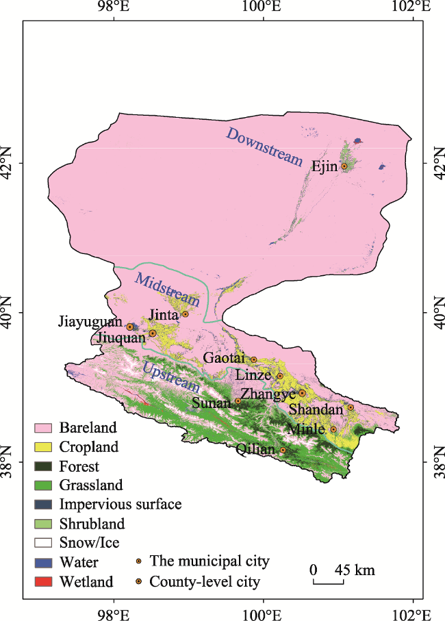
Fig. 1 Schematic diagram of the research area in the HRB |
Table 1 Current field observation stations in the HRB |
| Research institute | Field observation stations (network) | Research focus |
|---|---|---|
| Northwest Institute of Eco-Environment and Resources, CAS; Beijing Normal University | Integrated Surface Process Observation Network | Hydrology and ecology |
| Northwest Institute of Eco-Environment and Resources, CAS; Qilian Mountain Water Conservation Forest Research Institute of Gansu Province | Binggou Watershed and Onokou Observation Station | Hydrology and ecology |
| Northwest Institute of Eco-Environment and Resources, CAS | Linze, Hulugou, and Bayi Glacier Observation Stations | Ecological environment |
| Qilian Mountain Water Conservation Forest Research Institute of Gansu Province | Qilian Mountain Forest Ecological Positioning Research Station | Forest ecology |
| Lanzhou University | Teradayura, Linze, and Onoguchi Field Stations | Ecological environment |
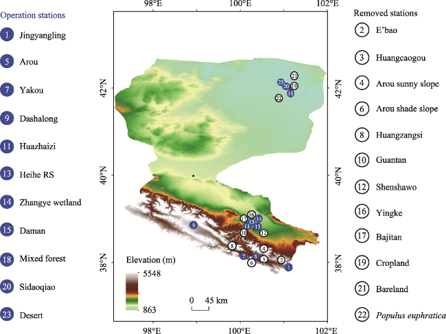
Fig. 2 Observation network for land-surface processes |
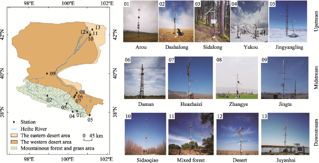
Fig. 3 Layout of comprehensive observation stations for HRB natural-resource elements |
Table 2 Details of stations established through cooperation |
| Stations | Basin | Station level | Underlying surface | Observation elements | Main equipment |
|---|---|---|---|---|---|
| Dashalong | Upstream | Third-level station | Alpine meadow | Weather, phenology, soil temperature, humidity, salinity | Ec, Aws |
| Sidalong | Third-level station | Forest | Weather, phenology, soil temperature, humidity, salinity, tree growth, trunk stem flow | Ec, Aws | |
| Yakou | Third-level station | Alpine meadow | Snow, weather, phenology, snow water equivalent | Ec, Aws, snow observation system | |
| Jingyangling | Third-level station | Alpine meadow | Weather, phenology, soil temperature, humidity, salinity | Ec, Aws | |
| Huazhaizi | Midstream | Third-level station | Desert | Weather, phenology, soil temperature, humidity, salinity | Ec, Aws |
| Zhangye | Third-level station | Wetland | Weather, phenology | Ec, Aws | |
| Mixed forest | Downstream | Third-level station | Oasis | Weather, phenology, soil temperature, humidity, salinity, trunk stem flow | Ec, Aws, phenological camera, LAI sensor network, observation of water table |
| Huangmo | Third-level station | Desert | Weather, phenology, soil temperature, humidity, salinity | Ec, Aws |
Note: Ec: Eddy covariance; Aws: Automatic weather station; LAI: Leaf area index. The same below. |
Table 3 Details of the three stations to be upgraded |
| Stations | Basin | Station level | Underlying surface | Observation elements | current equipment | Supplementary equipment |
|---|---|---|---|---|---|---|
| Arou | Upstream | Second- level station | Subalpine Meadows | Weather, four-component radiation, surface radiation temperature, photosynthetically active radiation, rainfall, snow depth, soil temperature, humidity, salinity | Ec, Dbs, gradient of meteorological elements, cosmos, phenology, soil moisture sensor network, precipitation | Water surface evaporation measurement, online automatic observation system for plant growth rhythm, groundwater monitoring system, automatic monitoring system for soil water quantity and quality |
| Daman | Midstream | Second- level station | Farmland | Weather, four-component radiation, surface radiation temperature, photosynthetically active radiation, rainfall, soil temperature, humidity, salinity | Ec, Dbs, gradient of meteorological elements, cosmos, phenology, soil moisture sensor network | Ec, online monitoring system for greenhouse gas flux, dry and wet settlement collection system, water surface evaporation measurement, water surface evaporation measurement, online automatic observation system for plant growth rhythm, power supply system |
| Sidaoqiao | Downstream | Second- level station | Oasis | Weather, four-component radiation, surface radiation temperature, photosynthetically active radiation, rainfall, soil temperature, humidity, salinity | Ec, Las, gradient of meteorological elements, cosmos, phenology, LAI sensor network, water table observation | Ec, soil temperature, automatic monitoring system for soil temperature, humidity and salinity, power supply system |
Note: Las: Large aperture scintillometer; Dbs: Dual-band scintillator; Cosmos: Cosmic ray soil moisture observation system. The same below. |
Table 4 Details of newly established stations |
| Stations | Basin | Station level | Underlying surface | Observation elements | Main equipment |
|---|---|---|---|---|---|
| Jinta | Midstream | Third-level station | Farmland | Weather, soil temperature, humidity, salinity, rainfall, radiation, snow depth, greenhouse gas flux | 10 m observation tower covering air temperature and humidity at 5 m and 10 m; wind speed and direction at 5 m and 10 m; four-component radiation, light, and effective radiation at 10 m;, rainfall, soil temperature and humidity (5 layers); one set each of evaporation, soil respiration, snow depth, greenhouse gas flux monitoring system, and weather camera systems |
| Juyanhai | Downstream | Third-level station | Wetland | Weather, soil temperature, humidity, salinity, rainfall, radiation, snow depth, greenhouse gas flux | 10 m observation tower covering air temperature and humidity at 5 m and 10 m; wind speed and direction at 5 m and 10 m; four-component radiation, light, and effective radiation at 10 m; and one set each of rainfall, soil temperature, humidity, and evaporation |
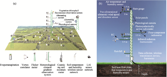
Fig. 4 Schematic diagram of (a) a second-level station and (b) a third-level station (Xu et al., 2020) |
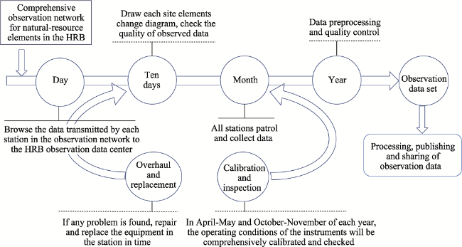
Fig. 5 Operation and maintenance program for the HRB observation network |
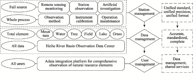
Fig. 6 Schematic diagram of quality control for observation of natural-resource elements |
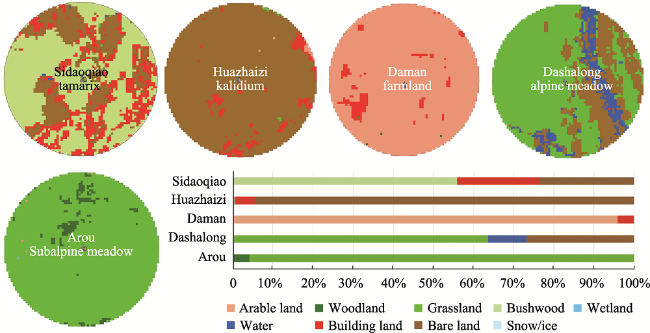
Fig. 7 The distribution of natural resources was obtained by comprehensive observation techniques at five stations |
| [1] |
|
| [2] |
|
| [3] |
|
| [4] |
|
| [5] |
|
| [6] |
|
| [7] |
|
| [8] |
|
| [9] |
|
| [10] |
|
| [11] |
|
| [12] |
|
| [13] |
|
| [14] |
Ministry of Natural Resources. 2019. A comprehensive observation system for natural resource elements has been established. http://www.mnr.gov.cn/dt/mtsy/201912/t20191218_2490347.htmlin Chinese)
|
| [15] |
Northwest Institute of Eco-Environment and
|
| [16] |
|
| [17] |
|
| [18] |
|
| [19] |
Synthesis Research Center of Chinese Ecosystem Research Network, CAS. 2010. Research progress and perspectives of synthesis research center of Chinese Ecosystem Research Network, Key Laboratory of Ecosystem Network Observation and Modeling, CAS. Journal of Natural Resources, 25(9): 1458-1467. (in Chinese)
|
| [20] |
|
| [21] |
|
| [22] |
|
| [23] |
|
| [24] |
|
/
| 〈 |
|
〉 |