Analyzing Livelihood

Spatial Distribution and Tourism Activation of Traditional Villages in Yunnan Province

  • XU Shaohui , 1 ,
  • DONG Liping , 2, *
Expand
  • 1. China Village Culture Research Center, Central South University, Changsha 410083, China
  • 2. Academician Workstation, Changsha Medical University, Changsha 410219, China
*DONG Liping, E-mail:

XU Shaohui, E-mail:

Received date: 2021-03-30

  Accepted date: 2022-03-24

  Online published: 2022-07-15

Supported by

The Graduate Investigation and Research Project of Central South University(2018dcyj020)

Abstract

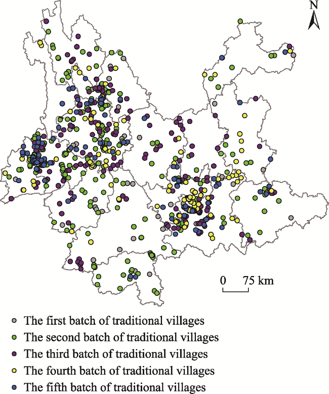
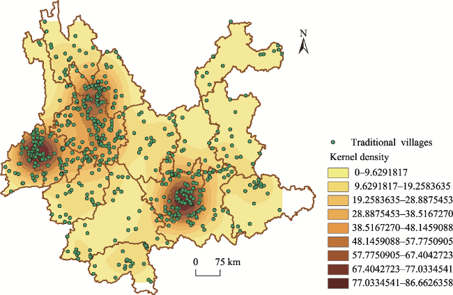
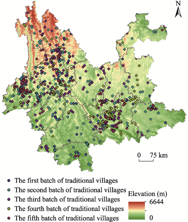
Using ArcGIS to analyze the spatial distribution of traditional villages in Yunnan Province in combination with the actual local conditions of traditional villages, the purpose of this study is to determine the development model suitable for their characteristics. The results show several important features of traditional village distribution. (1) The traditional villages in Yunnan Province have spatial structural characteristics of unbalanced cohesive distribution, and they are mainly distributed in the higher-level cities and prefectures such as northwest Yunnan, west Yunnan and south Yunnan. Among them, the traditional villages of Baoshan City have the highest distribution density of 66.33 per 10000 km2. This is followed by Dali Prefecture and Honghe Prefecture, where the densities of traditional villages are 44.13 per 10000 km2 and 37.66 per 10000 km2, respectively. (2) The factors affecting the spatial distribution structure of traditional villages in Yunnan Province are natural geographical factors, humanistic historical factors and transportation factors. Among them, the natural geographical conditions with a large vertical gap in Yunnan Province gave birth to the human settlement environment of traditional villages. The history of a farming civilization that has been passed down from generation to generation has laid a brilliant and splendid humanistic foundation for traditional villages, and the high-altitude areas are relatively primitive. The transportation conditions have delayed the destruction of traditional villages by urbanization and industrialization. In summary, these factors have affected the spatial distribution pattern of traditional villages in Yunnan Province to some extent. (3) According to the law of the spatial distribution of traditional villages in Yunnan Province, it is necessary to explore the activation path of traditional village tourism with regional characteristics and ethnic characteristics, and also to carry out differentiated development according to the different endowment characteristics of local resources, that is to develop a series of activation modes including agricultural tourism, cultural tourism and ecological tourism.

Cite this article

XU Shaohui , DONG Liping . Spatial Distribution and Tourism Activation of Traditional Villages in Yunnan Province[J]. Journal of Resources and Ecology, 2022 , 13(5) : 851 -859 . DOI: 10.5814/j.issn.1674-764x.2022.05.009

1 Introduction

Traditional villages refer to those villages that were formed early, have rich traditional resources in addition to certain historical, cultural, scientific, artistic, social, and economic values and should be protected (Sun, 2017). The traditional village carries the development history, cultural spirit and collective memory of the rural area, and its development and evolution is a historical testimony of the spread of Chinese farming civilization. The revitalization of traditional villages is a current hotspot in geography, architectural planning and other disciplines, and it also presents a practical difficulty in the context of rural revitalization. Some scholars have conducted research on the activation of traditional villages. In particular, relevant studies based on the perspectives of cultural geography, tourism geography, architectural planning and other disciplines have made great contributions to the theory of village activation. For example, there are some hot spots including the activation of traditional villages by borrowing and absorbing the three-layer cultural model of cultural geography (Gao et al., 2019). The first is the physical layer, including the construction of the geographical environment, landscape renewal, livelihood and life transformation. The second is the social level, including changes in social organization and social relations. Finally, there are the emotions and memories of the spiritual level, including the shaping of a sense of place and the awakening and reconstruction of collective cultural memories. From the perspective of tourism geography, the revival and sustainable development of traditional villages can benefit from tourism activation. Tourists from all over the world using traditional villages as tourist destinations can activate the traditional and modern developmental momentum of traditional villages. Therefore, the tourism activation of traditional villages can be achieved through gradual, communicative, network methods and means (Wu and Xu, 2017). From the perspective of architectural planning, some believe that the activation protection of traditional village residential heritage can be divided into a top-down model, a bottom-up model, and a combination of the two (Wang et al., 2017). The distribution of Chinese traditional villages has obvious regional differences, and shows a clustered distribution pattern. For example, Guangdong traditional villages are mainly distributed in four distinct clusters: Meizhou-Chaoshan District, Guangfo-Dongguan District, Zhanjiang- Leizhou District, and Qingyuan-Lianzhou District (Yuan et al., 2017), and traditional villages in Anhui Province form a polarized dense area in the southern mountainous area of Anhui (Wang et al., 2019). Many factors influence the spatial distribution of traditional villages, such as natural geography, transportation, industrial economy, culture history, etc. (Tong, 2015; Jiao et al., 2016; Kang et al., 2016; Feng et al., 2017; Sun et al., 2017; Chen et al., 2018; Wu et al., 2018).
Yunnan Province is one of the key distribution areas inhabited by ethnic minorities in southwestern China. There are 51 ethnic minorities such as Bai, Hani, Dai, Lisu, Wa, Lahu, Naxi and many others. After thousands of years of generational integration and cultural exchanges, Yunnan minority people and Han people have built a large number of traditional villages together. These traditional villages are living proof of the glorious history of farming civilization in Yunnan Province, and are also important carriers for the colorful Yunnan cultural tourism. At present, the research on Yunnan traditional villages mainly focuses on tourism development (Cheng et al., 2011; Che, 2017), intangible cultural heritage (Zong, 2014; Zeng and Tang, 2018), cultural landscapes (Cai, 2009; Xie, 2013), and archival research (Zhu, 2018). However, the existing research on the spatial structural distribution characteristics of traditional villages in Yunnan Province is insufficient. Therefore, it is necessary to conduct more in-depth research on the spatial distribution characteristics and influencing factors of traditional villages in Yunnan Province.
In Yunnan Province, a rural society supported by agriculture as a major industry has formed in the long course of its historical civilization. Thanks to the stability and cohesion of the farming civilization and its long-term avoidance of the ravages of war by virtue of its geographical location in the southwest of China, Yunnan Province has preserved 708 traditional Chinese villages. They account for 10.38% of the total number of traditional villages in the country, and Yunnan Province has the largest number of traditional villages in the country. Collectively, these villages are not only an important cultural heritage resource, but also an important cultural tourism resource. Studying the spatial distribution characteristics of Yunnan traditional villages and their influencing factors will help to promote the implementation of the Rural Revitalization Strategy and allow the rural tourism economy in Yunnan Province to remain active, resilient and sustainable for a long time.

2 Research area overview

Yunnan Province is located in the southwestern region of China, between 21°08°‒29°15°N and 97°31°‒106°11°E, and borders southeast Asian countries such as Myanmar, Laos, and Vietnam. The area of Yunnan Province is 3.941×10⁵ km2, of which the land area of the ethnic autonomous areas is 2.767×10⁵ km2. The topographic features of Yunnan Province are mainly mountainous areas, plateaus, and dams. The highest altitude peak is the Kawagebo Peak, the main peak of the Meili Snow Mountain in northwestern Yunnan, with a maximum altitude of 6740 m. The climatic characteristics of Yunnan Province basically belong to the subtropical plateau monsoon type. With the vertical change of the terrain, the climate presents a very significant stereoscopic characteristic. The average annual rainfall in Yunnan Province is 1278.8 mm. The development and utilization of agricultural resources in traditional villages have distinctive regional characteristics. The main cash crops include characteristic crops such as tobacco, sugarcane, tea, rubber, flowers, fruits, and vegetables, as well as Chinese herbal medicines such as Panax Notoginseng.
Yunnan Province has diversified natural geographic resources and rich historical and cultural resources. The Yuanmou people lived and proliferated here as early as 1.7 million years ago. Near the natural lakes, such as Dianchi Lake and Erhai Lake, local governments of ethnic minorities successively emerged, such as the ancient Dian kingdom, Nanzhao and Dali. Various mountains and rivers intersect in Yunnan Province. The Jinsha River, Lancang River, and Nu River flow through the high mountains such as Gaoligong Mountain, Nu Mountain, and Yunling Mountain, to form the world natural heritage of three parallel rivers. The unique climatic characteristics and long-term farming civilization have given birth to some of the world’s most important agricultural cultural heritages, such as Yunnan Pu’er ancient tea garden and tea culture system and Honghe Hani Terraced fields.

3 Research methods and data sources

3.1 Research methods

In order to more clearly visualize the spatial distribution of traditional villages in Yunnan Province, ArcGIS 10.5 was used to generate spatial distribution maps, kernel density maps, and elevation distribution maps of the traditional villages in Yunnan Province. Kernel density estimation is an important statistical analysis method for extracting the spatial distribution characteristics of sample points in a geographic area (Zhang, 2012; Kou et al., 2018; Tian et al., 2019). In this study, the density analysis tool in the spatial analysis tool of ArcGIS was used, and the kernel density analysis tool was selected to quantitatively analyze the spatial clustering characteristics of Yunnan traditional villages in the geographical area.

3.2 Data sources

The first five batches of 708 traditional villages in Yunnan have been identified and published by the Ministry of Housing and Urban-Rural Development, the Ministry of Culture and Tourism, the State Administration of Cultural Heritage, the Ministry of Finance, the Ministry of Natural Resources and the Ministry of Agriculture and Rural Affairs as the research target. In this study, the GPS positioning instrument and Baidu geographic information system were used to perform vectorized positioning processing on the Yunnan traditional village data. Using ArcGIS 10.5 as the technology platform, a geographic information database of Yunnan traditional villages was established, and a spatial distribution map of Yunnan traditional villages was drawn.

4 Spatial layout characteristics of traditional villages in Yunnan Province

4.1 Spatial distribution equilibrium of traditional villages

The spatial distribution of Yunnan traditional villages is generally unbalanced, with the villages mainly concentrated in Dali Prefecture, Lijiang City, Baoshan City, and Honghe Prefecture in the south of Yunnan Province. Yunnan Province includes 16 prefecture-level cities and prefectures, of which eight are provincial municipalities and eight are ethnic autonomous prefectures, specifically covering 16 municipal districts, 15 county-level cities, 29 ethnic autonomous counties, and 69 counties. There are 708 traditional villages in the 16 cities and prefectures of Yunnan Province. The average number of traditional villages in each prefecture is 44.25. Table 1 shows the number of traditional villages in each of the provinces and cities in Yunnan Province. The traditional villages in the top eight cities and regions (Dali, Baoshan, Honghe, Lijiang, Pu’er, Lincang, Yuxi, and Chuxiong) account for four-fifths of the total. Among them, the numbers of traditional villages distributed in Dali, Baoshan, and Honghe Prefecture are the largest, with each accounting for more than one-sixth of the total. This is followed by the traditional villages in Lijiang, Pu’er, Lincang, Yuxi and Chuxiong, which collectively account for more than one-fourth of the total. On the next level, the traditional villages in Qujing, Kunming, Wenshan, Dehong, Diqing and Nujiang combined account for about one-sixth of the total. The numbers of traditional villages in Xishuangbanna Prefecture and Zhaotong City are the smallest, representing less than one-thirtieth of the total.
Table 1 The statistics of traditional village distribution in each city and prefecture of Yunnan Province
City/Prefecture Number of traditional villages Rank Percentage (%)
Dali 130 1 18.36
Baoshan 130 1 18.36
Honghe 124 3 17.51
Lijiang 54 4 7.63
Pu’er 39 5 5.51
Lincang 36 6 5.08
Yuxi 36 6 5.08
Chuxiong 23 8 3.25
Qujing 21 9 2.97
Kunming 20 10 2.82
Wenshan 20 10 2.82
Dehong 19 12 2.68
Diqing 17 13 2.40
Nujiang 17 13 2.40
Xishuangbanna 14 15 1.98
Zhaotong 8 16 1.13
The spatial distribution pattern of traditional villages in Yunnan Province shows a clear cohesive trend. The densities of traditional villages in various cities and prefectures not only reflect the resource endowment foundations of the local villages, but they also reflect the local government's attitude towards traditional village inheritance protection and revival development. In terms of the coverage of traditional villages in various cities and prefectures in Yunnan Province, the spatial pattern of traditional villages shows an uneven distribution. Figure 1 shows that the first five batches include 708 traditional villages in Yunnan Province, and there are traditional villages in each city and prefecture. Among them, the numbers of traditional villages in Dali Prefecture (130 villages), Baoshan City (130) and Honghe Prefecture (124) are the largest, each accounting for more than one sixth of the total, while the total number of traditional villages in the remaining 13 cities and prefectures accounts for less than half. Figure 1 shows that the geographical distribution of traditional villages in different cities and regions is uneven, with a dense spatial distribution pattern of traditional villages in Dali, Baoshan, and Honghe Prefecture, which reflects the differences in the endowment of rural heritage resources between cities and prefectures, differences in the impacts of urbanization and industrialization on the traditional villages in various cities and prefectures, and different amounts of attention paid by the local governments and indigenous villagers to the protection and development of traditional villages.
Fig. 1 The spatial distribution map of traditional villages in Yunnan Province

4.2 Spatial distribution density of traditional villages

From the kernel density distribution map of traditional villages in Yunnan Province (Fig. 2) and the density distribution table of traditional villages in each city and prefecture (Table 2), it can be seen that the most densely distributed traditional village groups in Yunnan Province are the three core clusters of northwestern Yunnan, western Yunnan, and southern Yunnan. The density gradually decreases with the distance from these three core clusters. The core cluster area of the northwestern Yunnan traditional village group is Dali Prefecture, and the radiant hinterland close to the core gathering area of the northwestern Yunnan traditional village group is Lijiang City. The traditional villages in this area are densely distributed, which is related to the rich historical and cultural heritage passed down there. The core cluster area of the western Yunnan traditional village group is Baoshan City, and the radiant hinterland close to the core cluster area of western Yunnan is comprised of Dehong Prefecture and Lincang City. This distribution is related to the prolific natural geographical factors and distinctive human history factors in western Yunnan. The core area of the southern Yunnan traditional villages is Honghe Prefecture, and the radiating hinterland close to the core cluster area of southern Yunnan is Yuxi City. The dense distribution of traditional villages in this area is closely related to the well- preserved Hani terraced agricultural cultural heritage. In summary, the high density cluster areas of Yunnan traditional village are Dali Prefecture in northwestern Yunnan, Baoshan City in western Yunnan, and Honghe Prefecture in southern Yunnan. The median density cluster areas are Lijiang City, Dehong Prefecture, Lincang City, and Yuxi City near the three cores, and the radiation hinterlands far from the three cores are all low-density areas.
Fig. 2 The kernel density map of the spatial distribution of traditional villages in Yunnan Province
Table 2 The densities of traditional villages in each city and prefecture
City/Prefecture Density of traditional villages per 10000 km2 Rank
Baoshan 66.33 1
Dali 44.13 2
Honghe 37.66 3
Lijiang 26.21 4
Yuxi 23.55 5
Dehong 17.96 6
Lincang 16.52 7
Nujiang 11.56 8
Kunming 9.31 9
Pu’er 8.59 10
Chuxiong 7.93 11
Qujing 7.27 12
Xishuangbanna 7.15 13
Diqing 7.12 14
Wenshan 6.2 15
Zhaotong 3.48 16

4.3 Spatial layout characteristics of traditional villages on different terrains

Altitude is one of the important indicators for measuring the spatial distribution of traditional villages. Different altitudes and terrains will cause traditional villages to have different moisture, heat, and soil conditions, which will determine the unique local production methods and living habits, and reflect the characteristic local conditions of traditional villages. ArcGIS 10.5 was used to overlay the geographic location map of the Yunnan traditional villages with the DEM map to generate the altitude distribution map (Fig. 3). As can be seen from Fig. 3, the traditional villages in Yunnan Province are mainly located in Dali Prefecture and Lijiang City in northwestern Yunnan, Baoshan City in western Yunnan, and Honghe Hani terrace in southern Yunnan. The peasant masses built their traditional villages with a good living environment in the areas with mountains and rivers, which are located in the higher-altitude mountain plateau. This conforms to the simple ecological philosophy that traditional villagers inherited from generation to generation, which reflects the harmonious heaven-human relationship as well as the sustainable behavior following the natural laws. For example, in Dali Prefecture, backed by Cangshan and facing the Erhai Lake, the traditional villages are densely distributed, such as Xizhou Village, Zhoucheng Village, Chengbei Village, Qingdong Village and Shangguan Village in Xizhou Town, Shuanglang Village, and Changyu Village in Shuanglang Town, Longxiadeng Village in Dali Town, Gusheng Village in Wanqiao Town, Shalimu Village in Yinqiao Town and Qingsuo Village in Shangguan Town. Moreover, if we consider the many traditional villages distributed in Yuanyang Hani terraces with a higher altitude, such as Azheke Village, Qingkou Village, and Dayutang Village in Xinjie Town, Yakou Village in Panzhihua Town, and Taiyang Laozhai Village in Daping Town, the villages, terraces, water systems and forests are examples of world cultural heritage systems where humans and nature live in harmony. As a result, the Honghe Hani rice terrace system with simple intelligence of the traditional villagers was rated as a globally important agricultural heritage system. However, in the lower-altitude region of Kunming City, Yuxi City, Zhaotong City, and Xishuangbanna Prefecture, the distribution of traditional villages is sparse due to their destruction from urbanization, industrialization and tourism development.
Fig. 3 The elevation map of traditional villages in Yunnan Province

5 Factors influencing the spatial distribution of traditional villages in Yunnan Province

The factors influencing the spatial distribution of Yunnan traditional villages are mainly natural geographical factors, humanistic historical factors, and transportation factors. The natural geographical factors affecting the spatial differentiation of Yunnan traditional villages are related to the natural ecological environment formed during the long process of the earth’s evolution. The humanistic and historical factors are the folk culture traditions formed in the long-term process of agricultural civilization in Yunnan. The transportation factors are the traditional village location conditions that gradually formed during the long-term agricultural production and other economic activities.

5.1 Natural geographical factors

Natural geographical factors are the main external factors that affect the spatial distribution of traditional villages on a macro scale. The unique natural geographical location of Yunnan Province gave birth to the traditional villages’ close-to-nature human settlement environment system, and further shaped the regional cultural characteristics of the traditional villages. As traditional villages in Yunnan Province have been affected by natural geographical factors such as the topography, monsoon climate, river system, and sun light for a long time, the architectural style and terroir phenotype with characteristics of the rural villages in Yunnan have been formed. The natural geographical environment of Yunnan Province is very unique. The topography is complex and diverse, with mountains, hills, platforms, and plains as the main types. The geographical spatial distribution of Yunnan traditional villages is obviously affected by altitude factors. Compared with the lower-altitude areas such as Kunming City, Qujing City, Zhaotong City, and Xishuangbanna Prefecture, the higher-altitude areas such as Baoshan City, Dali Prefecture, Lijiang City, and Honghe Hani terrace have accumulated more traditional villages.

5.2 Humanistic and historical factors

Traditional villages in Yunnan Province are the precious relics of the farming, fishing and hunting civilization over thousands of years. The spatial distribution of the traditional villages among the various cities and prefectures is obviously affected by humanistic and historical factors. During the Warring States period, Yunnan traditional villages were the home of the Dian tribe. During the Tang and Song dynasties, with the establishment of local powers such as Nanzhao and Dali, a splendid human history was created, which affected the residential architecture, painting, art, and spatial layout of traditional villages in Dali prefecture. During the Yuan, Ming and Qing dynasties, the chieftains of Mufu participated in local governance, which enriched the historical and cultural background of the traditional villages in Lijiang City. Yunnan traditional villages have a long history of tea culture, and are especially famous for the cultivation, picking, transportation, and sales of Pu’er tea; and the Pu’er ancient tea gardens and tea culture systems are still preserved at present. So far, many traditional villages are still distributed along the ancient Tea Horse Road. The agricultural planting scope of the traditional villages in Yunnan Province has been continuously cultivated as the population has multiplied. Among them, the Honghe Hani rice terrace system has the most features, where the forests, villages, terraces, and water systems together form an ecological green agricultural cultural heritage landscape. As a result, the traditional villages are a living carrier of farming civilization, and they are densely distributed in the Honghe Hani terraced fields with a good agricultural culture that has continued and still exists today.

5.3 Transportation factors

Transportation conditions are relatively important factors that affect the spatial distribution pattern of traditional villages. Yunnan traditional villages have a splendid history of farming civilization. Yunnan Province has the largest number of traditional villages distributed throughout the country, which is related to its relatively primitive transportation conditions. So far, there are no railways in Baoshan City, Pu’er City, Lincang Prefecture, Dehong Prefecture, Diqing Prefecture, Nujiang Prefecture and Xishuangbanna Prefecture, so the traditional villages are widely distributed as well as more abundant and authentic in these regions. Meanwhile, Kunming City, Qujing City, and Zhaotong City have more developed transportation conditions, because they have many traffic arteries that connect to other mainland provinces, such as Shanghai-Kunming high-speed railway, Guangzhou-Kunming high-speed railway, Chengdu-Kun ming railway, Beijing-Kunming high-speed, Shanghai-Kunming high-speed, Guangzhou-Kunming high-speed. Therefore, these regions have been greatly affected by urbanization and industrialization over the years, and the number of traditional villages is relatively small.

6 Tourism activation of traditional villages in Yunnan Province

6.1 The tourism activation of traditional villages is exemplary

Traditional villages in Yunnan Province have a variety of agricultural tourism resources, cultural tourism resources and eco-tourism resources. The exploration of the tourism activation path of traditional villages in Yunnan Province is exemplary for the protection and inheritance of traditional villages across the country. For all of China, Yunnan Province is a major tourist destination and a strong tourism province. In 2019, the total number of tourists in Yunnan Province was 807167900, of which 799777700 were domestic tourists and 7390200 were overseas tourists. The total tourism revenue of Yunnan Province in 2019 was 1103.52 billion yuan, of which the domestic tourism revenue was 1067.951 billion yuan, and the international tourism revenue was 35.568 billion yuan. Traditional villages in Yunnan Province mainly activate their agricultural, cultural, and ecological resources through tourism activation paths such as agricultural tourism, cultural tourism, and eco-tourism. Traditional villages in Yunnan Province are distributed among mountains, plateaus and dams and have experienced significant climate change. There are rich and diverse agricultural landscapes, cultural landscapes and ecological landscapes, which attract tourists with different tourism motivations to come and experience.

6.2 Tourism activation of traditional villages activates cultural heritage

The traditional village group in Yunnan Province represent a world-wide cultural heritage, attracting tourists from all over the world, and promoting people-to-people bonds for all mankind. Among them, the traditional villages which are clustered and distributed in the southern Yunnan region still continue the agricultural cultivation tradition of terraced rice cultivation. Under the leadership of the local and central government, the Honghe Hani terraces were declared to be an important global agricultural cultural heritage. Therefore, it represents the government conveying to the world the image of agricultural civilization and agricultural tourism from Yunnan, China. The traditional villages which are clustered in the northwestern Yunnan region have been soaked in the commercial history of the Ancient Tea Horse Road since ancient times. It is natural to carry out reasonable and appropriate commercial development under the logic of capital improvement. Cultural tourism elements such as tea shops, caravans, and inns have attracted large numbers of domestic and foreign tourists to come for shopping, experience and vacation. The ecological environment of the traditional villages which are located in the western Yunnan region is relatively fragile. The ecological conservation function is strengthened under the leadership of the village collective, and the rural revitalization path of the village economy highlights the trend of ecological tourism activation. The cultural heritage of traditional villages in Yunnan Province is a precious treasure for all mankind. Therefore, it is necessary to scientifically and rationally activate tourism on the basis of maintaining the original ecology, original native soil and original culture, strengthen the reference to international models, and comparatively analyze the mature and successful international experiences and practices.

6.3 Agricultural tourism activation of traditional villages

Traditional villages in Yunnan Province are located on the subtropical plateau, with staggered mountains and rivers, as well as varied climatic conditions. In particular, this area is suitable for the growth of flowers, flue-cured tobacco, tea, coffee, rice and other crops in the Yunnan traditional villages. Therefore, the development of agricultural tourism with regional characteristics in Yunnan can effectively promote the active protection and sustainable development of agricultural farming in the traditional villages. Since ancient times, local people have regarded food as the sky and agriculture as the basic source of food. Traditional agriculture has always been the economic and livelihood basis of Yunnan traditional villages. Yunnan Province has a long history of agricultural farming, and its agricultural heritage is rich and diverse. The more well-known examples are the Honghe Hani rice terrace system, Pu’er and Shuangjiang Mengku ancient tea gardens and tea culture systems, Yangbi walnut-crop compound system, Guangnan Babao rice ecosystem, Jianchuan rice and wheat multiple cropping system, and Tengchong Binglangjiang buffalo breeding system. Those with constant production have perseverance, while those without constant production have no perseverance, and the traditional small-scale farmers with intensive cultivation have deep roots and lush leaves, and their households are very resilient and cohesive. For example, Honghe Hani people in the traditional villages are very hardworking, while the purple rice cultivated carefully on the terraces is an authentic geographical indication agricultural product. Thus, foreign tourists who come to experience the terraced landscape often buy local purple rice as a souvenir. The traditional villages in Yunnan have an especially profound agricultural heritage. Therefore, promoting the integrated development of agriculture tourism is conducive to consolidating the livelihood foundation for the peasants to live and work in peace. The key to the activation of agricultural tourism is to increase the income level of local farmers through tourists' experiences of agricultural farming and the purchases of agricultural specialties.

6.4 Cultural tourism activation of traditional villages

Traditional villages in Yunnan Province have rich and diverse cultural heritage resources. The development of cultural tourism can activate traditional houses, cultural festivals and intangible cultural heritage. According to the distribution pattern of Yunnan traditional villages, it is necessary to develop the cultural tourism industry with ethnic regional characteristics based on the particular type of local cultural heritage. There are many ethnic minority aggregate distribution areas in Yunnan Province. For example, Honghe Prefecture is the area where the Hani people mainly live, Xishuangbanna Prefecture is the area where the Dai people mainly live, Dali Prefecture is the area where the Bai people mainly live, Lijiang City is the area where the Naxi people mainly live, Nujiang Prefecture is the area where the Lisu people mainly live, and Diqing Prefecture is mainly the aggregate distribution area of the Tibetan people. Since the traditional villages of various ethnic groups in Yunnan Province are living cultural heritages, the vigorous development of cultural tourism is conducive to the widespread dissemination of excellent traditional culture. Yunnan Province is steeped in the fresh historical and cultural flavors of ethnic minorities, such as the Dongba civilization of the Naxi ethnic group, the water-splashing festival of the Dai ethnic group, the long street feast of the Hani ethnic group, the tie-dyeing craft of the Bai ethnic group, and the ancient tea-horse road. Therefore, the key pathway for activating cultural tourism development is to tell the stories of the original residents, and to uphold the differentiated cultural gene contexts in the local villages.

6.5 Eco-tourism activation of traditional villages

Yunnan traditional villages have excellent ecological environmental systems, natural space forms, and livable traditional buildings, so the development of eco-tourism is a natural trend. The topography and geomorphology of Yunnan Province are complex and diverse. The uneven distribution of precipitation and sunlight in various cities and prefectures has created diverse ecological resources in Yunnan traditional villages. Farmers use local natural resources to produce and live according to local conditions. For example, Tengchong City is very rich in geothermal resources, and natural hot springs are widely distributed in its traditional villages. Local peasants use the warm spring water for bathing and wellness. The traditional villages of Ruili City and Jinghong City are scattered in subtropical rain forests, and the Dai people use the prolific local bamboo to build green and low-carbon bamboo buildings. The traditional villages of Honghe Prefecture are distributed in an ecosystem consisting of forests, villages, terraces, and water systems. The Hani people use local thatch and soil to build ecologically livable mushroom houses. The Tibetan people in Shangri-La County are full of ecological wisdom, and tend to build traditional villages on poetic meadows. Therefore, traditional villages in Yunnan Province have a lively concept of ecological civilization. The development of ecotourism can activate local natural resource elements and enhance tourists’ ecological experiences of returning to nature.

7 Conclusions

Based on an ArcGIS analysis of the spatial distribution pattern of traditional villages in Yunnan Province, the spatial distribution pattern of traditional villages in 16 cities and prefectures in Yunnan Province was summarized. The factors affecting the spatial distribution pattern of traditional villages in Yunnan Province were analyzed, and the following conclusions were drawn. The traditional villages in Yunnan Province generally show an unevenly distributed cohesive pattern, mainly concentrated in the cities and prefectures with high altitudes. Among them, Dali City in northwestern Yunnan, Baoshan City in western Yunnan, and Honghe Prefecture in southern Yunnan have the highest densities of traditional villages. The main factors affecting the spatial distribution pattern of traditional villages in Yunnan Province are physical geography factors, human history factors, and transportation factors. The transportation conditions in the cities and prefectures with high altitudes are relatively primitive, and the agricultural civilization tradition is well preserved, inherited, and continued, therefore the distribution of traditional village groups is relative dense. However, the transportation conditions in the gentle dam area are more convenient, and the rich rural land characteristics are being lost in the dam regions which are more vulnerable to the impacts of urbanization and industrialization in addition to tourism development, thus the distribution of traditional villages in these regions is relatively sparse.
[1]
Cai L H. 2009. Landscape planning of Luoshui Mosuo Village near Lugou Lake in Lijiang, Yunnan Province. Chinese Landscape Architecture, 25(7): 53-57. (in Chinese)

[2]
Che Z Y. 2017. The evolution of spatial forms of traditional villages to small towns in tourism development. Tourism Tribune, 32(1): 10-11. (in Chinese)

[3]
Chen J Z, Liu D J, Zhou Y, et al. 2018. Spatial distribution and influential factors of traditional villages in Jialing River Basin. Economic Geography, 38(2): 148-153. (in Chinese)

[4]
Cheng H F, Li N, Mao Z R. 2011. Study on the dynamic mechanism of the renewal of traditional settelment under the background of tourism development. Journal of Architecture, (9): 100-103. (in Chinese)

[5]
Feng Y F, Yu W Y, Lei R L. 2017. Spatial distribution features and controlling factors of traditional villages in Guangdong Province. Scientia Geographica Sinica, 37(2): 236-243. (in Chinese)

[6]
Gao J, Hu Z, Zhao Z F. 2019. A sustainable path for local tourism urbanization of traditional villages—Taking Yuanjia Village in Shannxi Province as an example. Study of Natural and Cultural Heritage, 4(12): 26-32. (in Chinese)

[7]
Jiao S, Zheng Z M, Xu F, et al. 2016. The marginal tendency of the traditional village distribution: The case study of Hunan Province. Geographical Research, 35(8): 1525-1534. (in Chinese)

[8]
Kang J Y, Zhang J H, Hu H, et al. 2016. Analysis on the spatial distribution characteristics of Chinese traditional villages. Progress in Geography, 35(7): 839-850. (in Chinese)

[9]
Kou X W, Li W F, Jiang W D, et al. 2018. Spatial pattern and influence factors of rural settlements: A case of Siming Mountain area in Ningbo City. Mountain Research, 36(5): 784-791. (in Chinese)

[10]
Sun J T, Niu J J, Zhang K K, et al. 2017. Spatial distribution and influential factors of traditional villages in Shanxi. Human Geography, 32(3): 102-107. (in Chinese)

[11]
Sun J X. 2017. Traditional villages: Theoretical connotation and development path. Tourism Tribune, 32(1): 1-3. (in Chinese)

[12]
Tian P, Li J L, Shi X L, et al. 2019. Analysis on spatial-temporal changes of rural settlements and its influencing factors: A case study of Xiangshan County, Ningbo City. Mountain Research, 37(2): 271-283. (in Chinese)

[13]
Tong Y Q. 2015. The spatial differentiation factors of ethnic traditional villages in Guizhou. Economic Geography, 35(3): 133-137, 93. (in Chinese)

[14]
Wang Q, Ji H, Chen J G. 2017. A study on the dynamics of the preservation and vitalization of villages based on three cases in Fujian. Architectural Journal, (1): 108-112. (in Chinese)

[15]
Wang Y X, Li S, Jiu J T, et al. 2019. Research on the spatial distribution of traditional villages and influencing factors in Henan Province. Chinese Journal of Agricultural Resources and Regional Planning, 40(2): 129-136, 204. (in Chinese)

[16]
Wu B H, Xu X B. 2017. Tourism-oriented rejuvenation of Chinese traditional villages: An explorative research. Journal of Yangzhou University (Humanities and Social Sciences), 21(1): 5-21. (in Chinese)

[17]
Wu Q, Xu Y Y, Zhang Y L, et al. 2018. Spatial distribution characteristics and influencing factors of traditional villages in the Guangdong section of Xijiang River. Tourism Forum, 11(6): 81-91. (in Chinese)

[18]
Xie H Y. 2013. A study on spatial and time characteristics of forming mechanism of village cultural landscape illustrated by the example of Nuodeng Village. Chinese Landscape Architecture, 29(3): 60-65. (in Chinese)

[19]
Yuan S X, Tang G L, Zhang H O, et al. 2017. Spatial distribution pattern of traditional villages and brief analysis of Han Chinese subgroup characteristics in Guangdong. Tropical Geography, 37(3): 318-327. (in Chinese)

[20]
Zeng L, Tang X Q. 2018. Research on landscape imagery of traditional villages based on cultural representation theory—A case study of farmer painting of the Bai Nationality in Shuanglang of Yunnan. Journal of Nanjing University of the Arts (Art and Design), (4): 130-135. (in Chinese)

[21]
Zhang Q Y. 2012. Spatial pattern of rural settlements in loess hilly area—A case study of Tongwei County, Gansu Province. Journal of Mountain Science, 30(4): 408-416. (in Chinese)

[22]
Zhu T M. 2018. Research on archiving protection of ethnic minority traditional village in Yunnan. Archives Science Study, (3): 51-55. (in Chinese)

[23]
Zong L P. 2014. The rural settlement landscape and its evolution in Hani rice terrace culture landscape areas: A case study of the Quanfuzhuang Middle Village, Yuanyang County, Yunnan. Tropical Geography, 34(1): 66-75. (in Chinese)

Outlines

/