Ecological Community Management

Digital Analysis of the Water Layout Ecological Wisdom in Traditional Chinese Rural Settlements: A Case Study of Liukeng Village in Jiangxi Province

  • LI Zhe , 1 ,
  • HUANG Si 1 ,
  • WANG Han 2 ,
  • LI Yan , 1, *
Expand
  • 1. Key Lab of Information Technology for Architectural and Cultural Heritage Approved by the Ministry of Culture and Tourism, School of Architecture, Tianjin University, Tianjin 300072, China
  • 2. Government Offices Administration of People's Government of Guangdong Province, Guangzhou 510031, China

LI Zhe, E-mail:

Received date: 2020-11-10

  Accepted date: 2021-04-30

  Online published: 2022-04-18

Supported by

The National Natural Science Foundation of China(51878439)

The National Natural Science Foundation of China(51878437)

The National Natural Science Foundation of China(51908179)

The Project of Key Laboratory of Ministry of Culture and Tourism(20180508)

The Youth Foundation for Humanities and Social Sciences of the Ministry of Education(17YJCZH095)

The Social Science Foundation of Hebei Province(HB19YS036)

Abstract

During the long-term construction and development process of eliminating water disasters and promoting water conservancy in traditional settlements, a set of mature strategies that have simple ecological wisdom in water layout have been formed by adapting to the natural water environment and utilizing the regional water system. This study conducted a qualitative and quantitative analysis of the water layout strategies and their effects on Liukeng Village from three aspects: deciphering the water systematic pattern, calculating the spatial characteristics and quantifying the water environment, to explore the technical assistance and potential of water layout research in traditional rural settlements. The results indicated that Liukeng has an unambiguously systematic water layout pattern of source diversion, middle drainage and end purification of the water. Through 3D point cloud computing, it was shown that the site selection made accurate use of micro-topography and adopted the strategy of a multi-source water management. It formed an organic water system pattern, which provided sufficient water sources for all kinds of needs of Liukeng Village.The Dragon Lake in Liukeng held 83.0% of the precipitation, and the vegetation area accounted for 34.7% of the total area of Liukeng, which had high surface permeability and good middle drainage effects. Water detection showed that the Dragon Lake provided good water quality and purification. The purposes of this study are to fill the gap in previous non-quantitative research on water layout in traditional rural settlements, excavate the hidden information and value of settlements, and deepen our understanding of the ecological wisdom of the overall planning, layout and construction of water conservancy in traditional rural settlements. This knowledge can assist the win-win situation of water conservancy cultural heritage protection and modern utilization. It also provides useful inspiration and reference for properly dealing with the problems of rain and flooding, realizing the sustainability of water resources, and protecting the ecological environment in the process of the development and construction of village settlements in China.

Cite this article

LI Zhe , HUANG Si , WANG Han , LI Yan . Digital Analysis of the Water Layout Ecological Wisdom in Traditional Chinese Rural Settlements: A Case Study of Liukeng Village in Jiangxi Province[J]. Journal of Resources and Ecology, 2022 , 13(3) : 371 -381 . DOI: 10.5814/j.issn.1674-764x.2022.03.003

1 Introduction

Traditional settlements are communities where people live and work in an agrarian culture, and they are products of
human agricultural civilization. Since ancient times, traditional settlements have taken farming as the foundation of their livelihood, and water is the basis of productive life and the lifeblood of agriculture. In the process of the construction and development of traditional settlements, a set of mature strategies to eliminate water damage and revitalize water conservancy have been formed by adapting to the natural water resources and utilizing regional water systems. Water layout is a term that includes the meanings of water governance, treatment and management. An ancient Chinese garden book, “Yuan Ye”, records that “Jia Shan Yi Shui Wei Miao, Tang Gao Fu Chu Bu Neng Zhu Shui, Li Jian He Wu Shui, Si Shao Shen Yi” (or “rockery near the water is the best, if it cannot inject water in the high mound, constructing a low ravine without water seems to be less profound”) (Ji, 2018). This is the earliest understanding of the water layout for the Chinese.
Recent studies on ancient water layout are mainly based on archaeology (De Feo and Napoli, 2007; Nahm et al., 2012), environmental science (Ahmed and Abdelbary, 2004; Robles et al., 2019), biology (Onofre, 2005; Morehart, 2016) and other aspects of the water conservancy heritage. Objectively speaking, the large-scale water conservancy heritage around the world mostly relies on active water conservancy technology, and the functional direction is relatively singular. Due to the changes in the social system, wars and other various reasons, hydraulic engineering heritages in most countries have lost their original form and function. On the contrary, the water conservancy heritages of some historical settlements or communities with a certain usable area are still preserved due to the protection of residents, remote location, small land area, strong adjustability or other features (Yeom, 2007; Qiu et al., 2016). These water conservancy heritages, which are still in use, provide a more valid base of information and data for future research. In China, studies on the water layout of traditional settlements are mostly based on Chinese ancient concept of site selection (Chen and Liu, 1995; Liu, 2018), spatial patterns (Wang and Si, 2016; Min et al., 2018), the water system landscape (Liu et al., 1998; Fu et al., 2013) and water heritage (Zhang, 2012; Zhou, 2013). These lines of research under the traditional architectural perspective tend to be complete. From the perspective of planning, the analyses of settlement site selection, landscape, street space and other aspects (Liang, 1988; Wang et al., 2016; Li and Tian, 2018) are mostly focused on qualitative research on the public space, and lack the scientific quantitative analysis means and accurate scientific research results for micro-topography and the water environment. Meanwhile, there is a less in-depth interpretation of traditional settlement water environment adaptability in the interdisciplinary field. The studies of water systems in typical settlements in Jiangxi Province are mostly based on the Chinese traditional water ecology philosophy, showing the organic unity of man-made efforts and nature, and offering simple insights for conservation practice (Xu et al., 2017; Liu and Gu, 2018). In general, the cognition of water layout in the traditional settlement and the depth of research are both insufficient. Subsequently, it is difficult to carry out systematic and comprehensive protection of the water environment and water conservancy heritage of traditional settlements.
This study investigated the water layout of Liukeng Village, a typical traditional village in southern China, as an example. First, spatial data transformation was carried out through space-ground integrated information technology. The resulting village spatial point cloud model with accurate 3D data was used to sort out various kinds of features, extract the environmental characteristics, and reveal the hydrodynamic direction and trend in the micro-terrain. This step provided basic data for water conservancy analysis and a visualization of the implicit intrinsic value information of the traditional settlement regarding its water layout. Second, the information on water ecological environment quality was quantified through experimental detection, which can be used to fill in the missing link of index quantification in traditional settlement water layout conceptualization research. Traditional settlement water conservancy is a kind of complex heritage between nature and culture, which contains rich experience and wisdom. Compared with modern cities, traditional settlement water layout is an organic product of utilization from the natural resource and adaptation to the natural environment. The water layout of a typical traditional settlement has some merits in spatial planning, climate adaptation, water resource utilization and other aspects, which reflect the simple ecology and sustainability. These elements of wisdom and experience have been tested by historical practice, and can provide some ideas and methods that are worthy of learning and practicing in our contemporary construction. Therefore, this study provides useful enlightenment and reference for dealing with the problem of stormwater, realizing sustainable water resources, and protecting the ecological environment in the process of town development and construction in China today.

2 Materials and methods

2.1 Study area

Traditional settlement water conservancy is based on site selection, and topography is the basis of all water conservancy constructions. Most of the existing articles on the water layout of traditional settlements interpret the wisdom and characteristics of settlement site selection from the perspective of Chinese ancient concept. However, it is sometimes difficult to explain the scientific and reasonable location of a settlement with the ancient concept, and people who do not know it have difficulty in understanding its scientific nature. Also, not all settlements are perfectly in line with the basic principles of ancient concept of site selection which is “Fu Yin Bao Yang, Bei Shan Mian Shui, Cang Feng Ju Qi” (or “backing to the dark side and facing the sunny side, fronting water and with hills on the back, hiding the wind and gathering the air”) (Li et al., 2019). Liukeng does not conform to the ideal ancient concept because its village site is facing the open river in the lower reaches of the Wujiang River in the northwest. This further affects the comfort of human settlements after the cold current which is humidified by the river in winter. Therefore, when it is difficult to accurately express the scientific truth contained in village site selection, digital analysis means could be used to assess the strategy and wisdom behind the village site selection.
Liukeng Village belongs to the first batch of famous historical and cultural villages in China and has the reputation of being the first village through the Ages. Liukeng is located at the foot of Jingu Mountain in the southwest of Le'an County, Fuzhou City, Jiangxi Province, and is a typical ancient village in southern China. The topography around Liukeng is dominated by hills and mountains, followed by river valleys and plains. The mountains in central Jiangxi are both vertical and horizontal. There are small basins between the mountains. Liukeng is one of them, which is located in the transitional zone from the southeast mountain area of Lean to the middle and low hills in the west. There are fertile fields and fertile soil, surrounded by hills. Liukeng is located on the left bank of the Wujiang River, a tributary of the Ganjiang River. The Wujiang River comes from mountains in the southeast, and turns to the west after flowing past three sides of the village, making Liukeng a small peninsula. Such a site provides Liukeng with the necessary water conservancy conditions for its survival and development. The existing overall layout of Liukeng is in the style of the Wanli period of the Ming Dynasty, which has been going on for more than 400 years. The whole layout refers to the Lifang system of the city, but it is relatively loose and open in structure. In the village, a north-south inner lake called Dragon Lake divides the village into two parts. The whole village has luxuriant natural vegetation, excellent ecology and a beautiful environment.

2.2 Data sources

2.2.1 3D information acquisition

When the 3D point cloud data are applied to the traditional village water layout, the real 3D spatial recording and preservation of the village water conservancy facilities are completed first, which serves as the basis for all kinds of research work. Because this study needs to quantitatively interpret the spatial characteristics of traditional village water layout from macro to micro, it is necessary to obtain complete 3D data of the relatively open space, such as topography, artificial lakes and ponds, courtyard sites and so on. 3D spatial information is generally obtained by photogrammetry or laser scanning. During the investigation of Liukeng, UAV photogrammetry technology was used to collect the basic 3D data of Liukeng and its surrounding topography at the navigation height of 500 m and 100 m, respectively. A 3D point cloud model of topography with a radius of 2 km around the village and a complete fine 3D point cloud model of the village were calculated using the point cloud generation software Pix4D, PhotoScan or ContextCapture, which were then exported to las or txt formats and transferred to the point cloud processing software CloudCompare (Fig. 1).
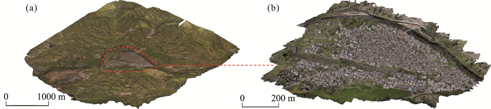
Fig. 1 Point cloud models with navigation height of 500 m (a) and 100 m (b) of Liukeng Village

2.2.2 Water sample collection

The collection of water samples in Liukeng Village mainly focused on Wujiang River water, mountain stream water, village ponds and groundwater. There are certain standard requirements for the layout of water sample collection points, and one of the important guiding ideas is to obtain the most spatially representative test data with the fewest points possible. Therefore, the number and locations of water sampling sites (Fig. 2) should be planned by the methods and steps specified in the national standard “Methods for Monitoring and Analysis of Water and Waste Water” (State Environmental Protection Administration of China, 2002). According to the sources of water samples collected, the types of water samples can be divided into surface water, water of a certain depth, spring well water and water from tap water or pumping equipment. Before collecting a water sample, the inner wall of the sampling container and the sample bottle should be washed 2-3 times with the corresponding collection water, and then the sample bottle is filled with the sampler. The water samples should be stored in polyethylene bottles, labeled according to the sampling order and location, and refrigerated at 4℃ for laboratory testing.
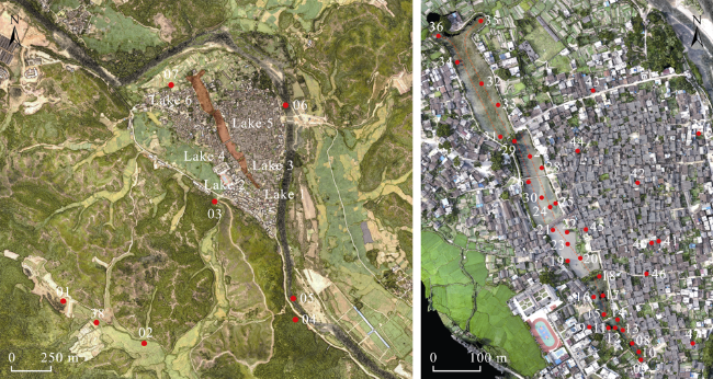
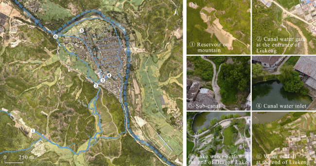
Fig. 2 Collection sites of water samples in Liukeng Village

Note: 01: Reservoir on the mountain; 02: Canal on the mountain; 03: Canal gate at village entrance; 04: Pond at the piedmont; 05: Upstream of the Wujiang River; 06: Midstream of the Wujiang River; 07: Downstream of the canal; 08: Intake of lake water (backflow); 09: Drain outlet; 10: The middle of lake 1; 11: Canal water inlet inside the eco-barrier; 12: Canal water inlet outside the eco-barrier; 13: The middle of lake 2; 14: Drain outlet of public toilet; 15: Lake water intake at the culvert; 16: Drain outlet outside the eco-barrier; 17: The middle of lake 3; 18: Lake water outfall; 19: Drain outlet 1 at the middle; 20: Drain outlet 2 at the middle; 21: Lake water outfall at the culvert; 22: Drain outlet of a beancurd mill; 23: The middle of lake 4; 24: Drain outlet inside the eco-barrier; 25: Drain outlet outside the eco-barrier; 26: Lake water outfall at the culvert of high part; 27: The middle of the lower part of lake 5; 28: Drain outlet of the lower part; 29: Lake water outfall at the culvert; 30: The middle of lake 5; 31: Lake water intake at the culvert; 32: The middle of lake 6; 33: Drain outlet at the middle of east bank; 34: Drain outlet at lake water outfall; 35: Right area; 36: Left area; 37: Domestic sewage drain tank; 38: Spring well on the mountain; 39: House well on the east bank; 40: Ancient well; 41: Pressurized well 1; 42: Pressurized well 2; 43: Pressurized well 3; 44: Pressurized well 4; 45: Pressurized well 5 (40 m deep); 46: Pressurized well 6; 47: Pressurized well 7 (6 m deep).

2.3 Research methods

2.3.1 3D point cloud computing

At the data level, the point cloud is the original 3D spatial data obtained by laser scanning and photogrammetry, which is stored in the form of spatial coordinates (X, Y, Z) and pixel values (R, G, B). It is a type of data file that can accurately express the 3D geometric features of the object surface. The 3D point cloud is a set of spatial point coordinates without a semantic difference, but the core operation of feature classification gives it basic scientific research value. The software CloudCompare is used in this study since it can integrate the color, surface direction and height position of the 3D point cloud, and semi-automatically divide the original chaotic point cloud or 3D model into independent data blocks of plant, roof, road network and so on. Feature classification is an important basis of spatial feature statistics. In the research on traditional settlement water layout, the first step is to study the location characteristics of the village, that is, to study the relationship between the geographical location and surrounding environment of the village. The 3D point cloud can accurately obtain the terrain data of traditional settlements, which not only helps us to analyze the settlement location strategy more intuitively and comprehensively, but also serves as scientific support for the ancient concept of site selection. The second step is to study the drainage facilities arranged along the streets and lanes in the settlement, and this process can use point clouds to determine the relationships between the layout of open drains and culverts and the trends of topography. The third step is to study the surface cover materials, such as vegetation, in the settlement. Vegetation has the function of conserving water. With the help of the 3D point cloud, the vegetation of a traditional settlement can be extracted to show the situation, distribution and quantity. The fourth step is to study the resistance to rain and flooding. The regulation and storage capacity of the settlement can be calculated with the help of the 3D point cloud, to reflect the rainwater consumption capacity of the traditional settlement under rainstorm conditions.

2.3.2 Water quality detection

The water quality detection index needs to be determined according to the characteristics of the various components of the water samples. As Liukeng is far away from the modern urban area, there are no industrial factories or mining sites around it, so heavy metal indicators cannot be examined. The pollution involved in the settlement area is mainly domestic sewage and agricultural non-point source pollution, so the investigation of water quality can focus on physical properties and nutrient pollutants. Based on the water samples collected during the investigation of Liukeng, the methods of field instrument measurement and laboratory analysis were used to focus the study of water environmental quality on the pattern of the traditional settlement water system. Thus, Acidity (pH), Turbidity Degree (TD), Conductivity (CDC), Dissolved Oxygen (DO), Total Phosphorus (TP), Total Nitrogen (TN) and Ammonia Nitrogen (NH3-N) of settlement water were quantitatively detected and compared. Standardized data can be used to express the environmental quality of water intuitively and objectively, and help people to accurately understand the water quality purification effect of the traditional settlement water system pattern. It can be used to explore the early wisdom of traditional settlement water conservancy practices in water quality treatment and ecological maintenance. The methods used in the testing are also carried out in strict accordance with the practices and steps stipulated in the national standard of “Methods for Monitoring and Analysis of Water and Waste Water”.

3 Results

3.1 Source water diversion

From the point of view of ecology, geography and water conservancy, there are still more problems to discuss in the ideal model put forward by ancient concept of site selection. Some examples include the relationship between the diversity of water demand and village site selection, the requirements of village farming and irrigation on the water environment, the influence of river flow direction and altitude on village site selection, and others. The solutions of these problems can directly show the positive response of water layout to the climate environment, which proves that the traditional rural settlement plan considered how to effectively use the rich water sources from the macro to the micro construction, and thus put forward the multiple water source strategy of the traditional rural settlement water layout.

3.1.1 Micro-topography of site selection

The spatial coordinate z-axis value of each point in the village point cloud was extracted and converted into a scalar field of the relative height of the space, and the elevation 3D point cloud model of Liukeng and the surrounding terrain was obtained (Fig. 3). Figure 4a shows that the site of Liukeng is located in a flat area between high mountains and low water, and the average height difference between the village base and the Wujiang River is about 4 m, so Liukeng Village is actually on a small platform. The construction of the village did not occupy the entire platform area but kept the northwest edge of the village in the same straight line as the northeast valley to avoid the prevailing northeast wind blowing from the northeast valley in winter (shown by the black dotted line and arrow in Fig. 3a). A green line cracks in the mountains of the red area on the southwest side of the platform, showing the low-lying part of the mountains. Combined with field investigation, the source of living water in Dragon Lake is drawn from the mountain streams flowing from the mountains in this direction (shown by the white dotted line and arrow in Fig. 3a). Figure 4b shows an elevation map of ancient Liukeng with the ground objects removed (the range around red dotted line). The Dragon Lake is located in the blue belt inside the platform which is a low depression. Elevation calculations show that the Dragon Lake water level is higher than the Wujiang River water level by about 2 m, which further questions the viewpoint that “the living water source of Dragon Lake is drawn from Wujiang River” (Min et al., 2018). Besides in the northwestern nearby river area, there is a significant altitude difference between Liukeng Village and Wujiang River, which cannot be overcome by using natural forces from Wujiang River excavation ditches. Using the high-water level from upstream of Wujiang River to carry water by natural forces would be too long and costly. Under the condition of vague written records, terrain visualization can be used to find the source of living water in Liukeng Village.
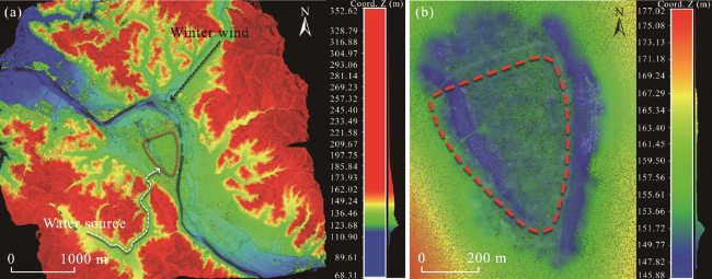
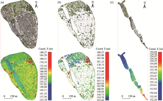
Fig. 3 Elevation pseudocolor map of micro-topography (a) and the ancient foundation (b) of Liukeng Village

Note: Coord.Z means relative height of Z coordinate of point cloud.

3.1.2 Overall pattern of the multiple water sources system

The investigation of the water sources of Liukeng found that they can be summarized as three kinds: Mountain streams, Dragon Lake and Wujiang River. The living water source of Liukeng comes from several streams along its southern and southwestern hills, streams and rain, which sinks into a reservoir, then flows into an artificial canal through sluice holes beneath the dam. For water transportation downhill, some canals were dug along roads. When a canal ran through cultivated land, it would extend longer and further into the fields for irrigation. The canals flow into the entrance of Liukeng, forming a small pool. The water outlet sets two gates. The large gate water does not enter the village but flows northwest across farmland into the Wujiang River. The small gate water enters the northeast into a sub-canal, and eventually flows through the village into Dragon Lake as a supply of living water (Fig. 4b). Mountain streams, Dragon Lake and Wujiang River form the whole water source system, which provides sufficient water for the needs of farming, transportation, defense and so on. After understanding the micro-topography and water source of Liukeng, this study combed the spaces and relations between different water bodies, and formed an organic whole through unified construction, which yields the structural pattern of the water system in Liukeng (Fig. 4a). It forms a whole frame for the water layout logic of the traditional rural settlements.
Fig. 4 Water layout of Liukeng Village: Overall pattern (a) and nodes (b).

3.2 Middle water drainage

This section describes the classification and calculation of objects based on the 3D point cloud of Liukeng, and the appropriate extraction methods used for different objects. Color feature information of vegetation was used to extract the plant point cloud, and the Dip screening method with high integrity was used to select and remove the Dragon Lake point cloud. Finally, statistics showed that different objects occupy different areas within Liukeng Village (Table 1).
Table 1 Classification statistics of ground objects in Liukeng Village
Objects type Liukeng Village Plants Houses Roads Dragon Lake
Area (m2) 363454.5 126022.5 122275.3 77330.5 37826.2
Proportion (%) 100.0 34.7 33.6 21.3 10.4

3.2.1 Surface infiltration

Through point cloud computing, the whole village area is about 363454.5 m2 (Fig. 5a). After separating the vegetation point cloud, the calculation showed that plants cover about 126022.5 m2, accounting for about 34.7% of the total Liukeng area (Fig. 5b). Vegetation is different from earth rock pavement in the pervious ground surface. Because vegetation has ecological functions closely related to climate, soil, topography, and water condition, its influence on water conservation, reducing runoff, improving ecological microenvironment, and enriching the landscape cannot be ignored. From the water layout perspective, soil and plant roots are equivalent to a large sponge. When it rains, they can absorb rainwater, and promote moisture seepage slowly underground, not only preventing soil erosion, but also helping to reduce rainwater runoff, which is an important auxiliary factor for the water layout of traditional rural settlements. Rainwater in Jiangxi Province brings water resources for villages while it also causes negative impacts such as the erosion of soil, agricultural nonpoint source pollution, large surface runoff and even flooding. Therefore, the existence of green vegetation can effectively alleviate or even eliminate the negative effects caused by this rainfall.
Fig. 5 Point cloud extraction and area calculation of ancient Liukeng (a), plants (b) and Dragon Lake (c).

Note: Coord.Z means relative height of Z coordinate of point cloud.

3.2.2 Storage capacity of Dragon Lake

It is widely acknowledged that ponds and lakes have important regulating functions in villages, but their specific storage capacity lacks corresponding statistical data. Storage capacity can be reflected by lake water storage capacity so we can extract the Dragon Lake point cloud separately. This calculation showed that the total area of Dragon Lake is 37826.2 m2, occupying 10.4% of the whole area of Liukeng (Fig. 5c). Using the UAV aerial survey to obtain the depth of Dragon Lake, it was found to be 2.5 m when the lake is desilting in summer. The maximum storage capacity of Dragon Lake is about 94565.5 m3, so the water accumulation situation of Liukeng under extreme circumstances can be calculated. According to Fuzhou hydrological records, the maximum daily rainfall in the region is 350 mm (Zheng et al., 2012). Using the area covered by Dragon Lake as the catchment area, then the village catchment amount is about 113969.9 m3 under rainfall. After filling the whole Dragon Lake, it contains 83.0% of the rainwater, and the remaining 19404.4 m3 of water accumulates on the ground. Therefore, the average water accumulation of the village ground is 53 mm m-2, and the ground of Liukeng is permeable so that this degree of rainfall does not pose a serious threat.

3.3 End water purification

The Dragon Lake at the end of Liukeng Village's water layout pattern is composed of six artificial ponds which have height differences, and it is located in the low terrain in the middle of the village site. The six ponds are arranged from southeast to northwest, and the adjacent ponds are connected by culverts, falling one by one, and their areas gradually change from small to large. The mountain stream, the living water source of Dragon Lake, flows into lake 2, then flows back to lake 1, and uses the elevation difference of the terrain to flow to the downstream lake. Along the coast of Dragon Lake is a stone-piled upright barge with large and small sewage outlets, connecting the drainage ditches from various streets and alleys. Lake 6 has two bi-furcations at the end, extending to the northeast and west of the farmland. Among them, there is a small canal in the northwest corner of the west fork, which connects the Wujiang River after passing through the farmland. When the Dragon Lake is full of water during the flood season, it can be discharged into the Wujiang River through this small canal to ensure the basic safety of the residents. At this point, as the waterway of the whole Liukeng extends in all directions in the village, it is connected with the river outside the village, forming an organic whole system. The water layout not only pays attention to the spatial dredging and storage of water quantity, but also involves the purification and treatment of water quality.

3.3.1 Testing results and analysis of water quality

Figure 6a shows that most water in Liukeng complies with the 6-9 ranges specified in the water pH standards. However, because of the acidic red soil, the pH of the reservoir and spring well on the mountain (No. 01 & No. 38) are less than 6. Conversely, the pH of the right area at the end of Dragon Lake (No. 35) is more than 9, because Dragon Lake accepts the entire village's living sewage.
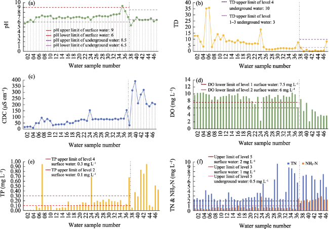
Fig. 6 Acidity (pH, a), Turbidity degree (b), Conductivity (c), Dissolved oxygen (d), Total phosphorus (e), and Total nitrogen and ammonia nitrogen (f) Testing results of water samples in Liukeng Village.
Figure 6b shows that there are four places with larger turbidity variations, Wujiang River (No. 05 & No. 06), drain outlet inside eco-barrier of lake 5 (No. 24), domestic sewage drain tank (No. 37) and pressurized well 7 (No. 47). There is much sediment in Wujiang River and strong pollution intensity at the other three places. Among the ten wells, only one pressurized well water TD is more than 3 degrees below 10 degrees and belongs to level 4 water quality. At the six ponds of Dragon Lake from upstream to downstream, TD decreases generally and water purification plays a certain role.
Figure 6c shows that the conductivity of the mountain stream (No. 04) is lowest and the conductivity of the ancient well water (No. 40) is highest. The conductivity of well water is higher than the other water samples. At the six ponds of Dragon Lake from upstream to downstream, the conductivity value increases overall, indicating that the ion concentration increases in the water. The water samples of the drain outlet inside the eco-barrier of lake 5 (No. 24) and domestic sewage drain tank (No. 37) show higher conductivity values than the other water samples.
Figure 6d shows that the overall level of dissolved oxygen in the surface water is relatively high, which mostly conforms to the standard requirements of level 1. Two places that do not meet the level 1 criterion are the drain outlet of the beancurd mill (No. 22) and the drain outlet inside the eco-barrier of lake 5 (No. 24). The beancurd mill directly discharges high concentration organic wastewater to the lake which leads to a decrease in dissolved oxygen content in this area. Inside the eco-barrier of lake 5 is a concentrated sewage pretreatment area outlet which contains water hyacinth. It is mainly responsible for decreasing the dissolved oxygen content in this area.
Figure 6e shows that the mountain stream belongs to the level 2 water category, and the whole lake belongs to the level 4 water category. According to the reservoir function for the control of water quality classification criteria, the TP index conforms to level 5 water content regulations, does not exceed the standard, and meets the irrigation water requirement, which indicates that Dragon Lake effectively carries out the TP degradation effect, and controls it within a reasonable range.
Figure 6f shows that there are problems of standard exceedances for TN in the surface water and NH3-N in the groundwater. This indicates that nitrogen pollutants contained in Dragon Lake exceed the ability of the water to degrade total nitrogen, whereas nitrogen pollutants could pollute underground drinking water. There may be two reasons for this problem. First, with current economic society, tourism development of traditional settlements brings more tourists into the villages, and an increasing population means an increasing amount of discharge pollution needs to be handled by the villages. Second, along with social and industrial development, village residents' production lifestyle is influenced by modernization, compared with the primitive farming society, so the nitrogen pollutants are discharged from production activities and their concentrations have all increased.

3.3.2 Overall evaluation of water environment quality

Based on the above water quality test results, the quality and compliance of the water environment of Liukeng studied in this paper were summarized against the national water quality standards (GB 3838-2002; GB/T 14848-2017). Table 2 shows the evaluation results of various indicators of the water environment of Liukeng (level 1 to 5 quality reduction).
Table 2 Water environment quality in Liukeng Village
Type Sample pH TD DO TP TN NH3-N Over-standard
Surface water Stream 1-5 / 1 1 5 2 TN
River 1-5 / 1 2 > 5 2 TN
Lake 1-5 / 1 5 > 5 3 TN
Ground water Well 1-5 1-3 / / / 5 NH3-N
On the whole, the water environment quality of Liukeng Village is good, and among the six indicators tested, five of them meet the corresponding water quality standard limits, or are even better than the standard requirements. But at the same time, there are some problems. The TN and NH3-N values were higher than the standard. Basically, the lake and pond water system environment created by water conservancy in the traditional rural settlement has the function of sewage purification and undertakes the main water treatment task of the village, which makes the overall quality of the water ecological environment good. However, there is a limit to the self-purification capacity of the village water conservancy. With the transformation of the production and lifestyle of the traditional rural settlements, the increase in the discharge of some pollutants may have exceeded the range of the self-purification capacity of the village water environment. The water environment of traditional villages still shows such problems under the condition of good quality overall. This kind of problem not only exists in Liukeng Village, but it is also a universal problem faced by traditional rural settlements at present.
Because of this phenomenon and the associated problems, greater attention should be paid to timely discovery and the measures to deal with them when studying and protecting traditional rural settlements. When necessary, based on such evaluations, the intervention of modern sewage treatment technology and artificial water ecological restoration can be considered to solve the eco-environmental problems of water quality. Taking the problem of exceeding the standards of TN in village surface water and NH3-N in groundwater as an example, independent discharge and collection channels should be set up for human and animal excreta discharged from the village, and separate ponds should be set up to deal with these pollutants in a centralized manner. At the same time, the construction technology of the artificial water ecosystem can strengthen the natural self-purification function of village water and improve the environmental capacity of the water for nitrogen pollutants. When using modern technology to solve the problem of environmental pollution in villages, the style and features of the village should be respected, and measures should be adjusted to local conditions. Based on the principles of simplicity and practicality, convenient management and a small project quantity, the coping strategy which is suitable for the natural environment, economic environment and population scale of the traditional rural settlement can be chosen.

4 Conclusions

There is a close relationship between water and spatial environmental elements in traditional settlements. In terms of the relationship between water sources and farmland plots, different farmland plots have different water sources, and there is also a positive correlation between water quantity (catchment area) and farmland area. Farmland areas in different locations within the micro-topographic pattern are suitable for different kinds of planting. The upstream water has low temperature and organic matter, while the downstream water is mixed with high organic matter. The strategy of farming should conform to this rule as much as possible. Generally, the upstream of the village water system is closer to the forest, so the water is cleaner and less organic. It is more suitable for washing and livestock drinking water. In the process of flowing through the built-up area, the water quality deterioration is the fastest. With a higher degradation demand, a greater total volume of water and lower flow rate of water are required, thus creating a lake or pond. Therefore, the water layout strategies for traditional settlements can be summarized as follows. The principle is to make full use of the underlying micro-topographic pattern and to minimize the amount of work. It is most critical to determine the village site and the street pattern, and then decide on the drainage, washing, farming and other activity paths. Based on the basic planning pattern (village site, mountain, forest, water, grass, and field), the deficiencies and factors that can be connected to each other are revealed. Then, with a little bit of guidance, a self-consistent system can be formed in terms of runoff direction, water quantity and water quality.
Traditional rural settlements are good at utilizing terrain, especially in grasping and applying micro terrain fluctuations, which not only reduces the construction quantity of the village water conservancy, but also creates a vivid landscape. Today some areas of new rural construction projects in China are neat and tidy, but have the same look. The layout of the grid pattern ignores the utilization and respect of site characteristics and makes the pattern construction on the ground floor. It is a pity and a loss that the original natural features of the village are buried. During the planning or design stage, builders can use the thinking patterns of the traditional rural settlements, and make uneven terrain changes as a kind of natural resource that can be utilized simultaneously as the basis and prototype of curve design. Construction quantity and the acquired style effect may be another benefit.
Traditional villages distinguish between water resources with different qualities, which is essentially a kind of simple classification consciousness of the water. Villagers use clean and high-quality groundwater as drinking water, less polluted water as washing water, and low-quality water with high nutrient content as irrigation water. Each type of water can exert its effect as much as possible. Today we classify water according to water quality but do not do very well in practical use. Various kinds of water resources are abandoned under the condition of utilization value, which is virtually a waste of water resources. Therefore, learning the water resource concepts of traditional rural settlements can enhance the utilization of different water resources, which is a countermeasure of relief for the urban water shortage problems.
Combining current data processing with the historical literature retrieval method can effectively fill the gaps of spatial quantification, excavate hidden information and value, and deepen our understanding of location planning and ecological wisdom construction, which is a trend in the research on traditional rural settlements in the present and future. With more and more traditional villages in China, the research becomes more and more thorough. This research is not only an attempt at traditional village water conservancy heritage digital analysis, but also explains the potential for mining and improvements in current village water conservancy research. China still has many valuable village water conservancy projects that urgently need to be studied and protected. Hopefully, through more comprehensive and deeper research, the traditional rural settlement water conservancy cultural heritage protection and modern utilization can achieve a win-win situation.
[1]
Ahmed A F, Abdelbary M R. 2004. Effect of Aswan high dam operation on river channel capacity to convey discharges. Proceedings of the 9th International Symposium on River Sedimentation, 18-21 Oct 2004. Yichang, China.

[2]
Chen H, Liu P L. 1995. The spacial pattern of Chinese ancient concept and its impact on Chinese traditional urban planning. City Planning Review, 19(4): 18-21, 64. (in Chinese)

[3]
De Feo G, Napoli R M A. 2007. Historical development of the Augustan Aqueduct in southern Italy: Twenty centuries of works from Serino to Naples. Water Supply, 7(1): 131-138.

[4]
Fu J, Xu J H, Xiao D W. 2013. Research on the shape and landscape of southern traditional villages based on water environment. Chinese Landscape Architecture, 29(8): 120-124. (in Chinese)

[5]
General Administration of Quality Supervision,Inspection and Quarantine of the People's Republic of China. 2017. Quality standard for ground water (GB/T 14848-2017). Beijing, China: China Environmental Publishing Group. (in Chinese)

[6]
Ji C. 2018. Yuan ye. Beijing, China: China Architectural Industry Press. (in Chinese)

[7]
Li Y F, Tian G H. 2018. Flowing water and gardens in each residence: Enlightenment of river governance in the ancient capital of Luoyang to the sponge city construction. Modern Urban Research, (2): 32-39. (in Chinese)

[8]
Li Z, Sun S, Zhou C C Q, et al. 2019. The optimized access to the digital museum of traditional Chinese villages exploring and quantifying the wisdom of traditional villages by three-dimensional computation. Architectural Journal, (2): 74-80. (in Chinese)

[9]
Liang X. 1988. Views on Chinese ancient concept from settlement site selection. New Architecture, (4): 67-71. (in Chinese)

[10]
Liu H B, Gu X R. 2018. Water ecological wisdom and practice of traditional village: Inspiration from Liukeng Village in Fuzhou, Jiangxi for rural revitalization. Ecology and Environmental Monitoring of Three Gorges, 3(4): 51-58. (in Chinese)

[11]
Liu P L, Dong S S. 1998. Study of landscape-image of Chinese ancient village. Geographical Research, 17(1): 32-39. (in Chinese)

[12]
Liu T F. 2018. A science analysis of the natural water system of the book of Shuilong. New Architecture, (6): 152-155. (in Chinese)

[13]
Min Z R, Huang P, Duan Y P. 2018. Analysis the wisdom of the traditional village's drainage system: Taking Liukeng Village in Jiangxi Province as an example. Urban Development Studies, 25(1): 7-11. (in Chinese)

[14]
Ministry of Ecology and Environment of the People's Republic of China. 2002. Environmental quality standards for surface water (GB 3838- 2002). Beijing, China: China Environmental Publishing Group. (in Chinese)

[15]
Morehart C T. 2016. Chinampa agriculture, surplus production, and political change at Xaltocan, Mexico. Ancient Mesoamerica, 27(1): 183-196.

DOI

[16]
Nahm W H, Kim J K, Kim J Y, et al. 2012. Topographical evolution and 14C age dating of the construction of the Eurimji Reservoir (Jecheon, Korea). Journal of Archaeological Science, 39(12): 3706-3713.

DOI

[17]
Onofre S A. 2005. The floating gardens in Mexico Xochimilco, world heritage risk site. City & Time, 1(3): 47-57.

[18]
Qiu Z M, Chen B X, Koji N. 2016. Customary management system of irrigation ponds in Japan: A case study in a globally important agricultural heritage systems (GIAHS) site of Noto Island, Ishikawa Prefecture. Journal of Resources and Ecology, 7(3): 205-210.

DOI

[19]
Robles B, Flores J, Martinez J L, et al. 2019. The chinampa: An ancient Mexican sub-irrigation system. Irrigation and Drainage, 68(1): 115-122.

[20]
State Environmental Protection Administration of China. 2002. Methods for monitoring and analysis of water and waste water. Beijing, China: China Environmental Publishing Group. (in Chinese)

[21]
Wang Y C, Meng X D, Zou Q. 2016. The pattern language and its application in public open space in traditional village. Chinese Landscape Architecture, 32(11): 44-49. (in Chinese)

[22]
Wang Y K, Si Z. 2016. Analysis on the water-management art of Xidi ancient village in Huizhou. Huazhong Architecture, 34(6): 152-156. (in Chinese)

[23]
Xu D M, Wang M M, Wang Y C. 2017. Link between man-made system and nature: Inspired by the eco-phronesis of Meipei ancient village in Jiangxi Province. South Architecture, (6): 111-115. (in Chinese)

[24]
Yeom J S. 2007. Irrigation policy and Byeokgolje of Gimje in the early Joseon Dynasty. Korean Journal of Agricultural History, 6(2): 79-105.

[25]
Zhang N Q. 2012. Evaluation of water conservancy heritage based on value assessment. China Water Resources, (21): 8-9. (in Chinese)

[26]
Zheng J G, Deng J B, Cai X Q. 2012. The climate characteristics of rainstorm in Fuzhou in recent 50 years. Meteorology and Disaster Reduction Research, 35(4): 64-68. (in Chinese)

[27]
Zhou B. 2013. Discussion on classified protection and utilization method of water cultural heritage in scenic spot. China Water Resources, (19): 62-64. (in Chinese)

Outlines

/