Ecological Community Management

Research on the Integrated Planning of Blue-Green Space towards Urban-Rural Resilience: Conceptual Framework and Practicable Approach

  • YU Qiao , 1, * ,
  • DU Mengjiao 1 ,
  • LI Haochen 1 ,
  • TANG Xizi 2 ,
  • LI Xiaoyan 3
Expand
  • 1. College of Architecture and Urban Planning, Chongqing Jiaotong University, Chongqing 400074, China
  • 2. School of Architecture, Southwest Jiaotong University, Chengdu 611756, China
  • 3. School of Architecture and Urban Planning, Chongqing University, Chongqing 400030, China

Received date: 2020-10-31

  Accepted date: 2021-07-21

  Online published: 2022-04-18

Supported by

The National Natural Science Foundation of China(52008062)

The National Natural Science Foundation of China(51908469)

The Science and Technology Research Program of Chongqing Municipal Education Commission(KJQN202100735)

Tuojiang River Basin High-quality Development Research Center, A Key Research Base of Social Sciences in Sichuan Province(TJGZL2021-12)

Abstract

Facing the impacts of climate change and the ecological environmental problems caused by urbanization, urban-rural resilience is a new value goal of territorial space development. Blue-green space is an interconnected network system of natural and artificial green space and water bodies, which can dissolve the internal and external pressures of the system by way of mitigatory acceptance and adaptive interaction, reduce the impact of climate change and artificial construction disturbances, and provide diversified composite functions. By recognizing the connotation of the concept of blue-green space, its composite ecological functionality and its relationship with the value of urban-rural resilience, this paper constructs a conceptual framework for the integrated planning of blue-green space in urban and rural areas with “resilient objectives, resource identification, integrated configuration, differentiated regulation”. The paper proposes an integrated and coordinated multi-scale practicable approach of blue-green space planning (i.e., the construction of the blue-green corridor network, the configuration of blue-green open space, the allocation of blue-green infrastructure) and the regulation-based urban-rural transect, with the aim of improving the hydroecological performance and composite functional services in order to realize urban and rural resilience.

Cite this article

YU Qiao , DU Mengjiao , LI Haochen , TANG Xizi , LI Xiaoyan . Research on the Integrated Planning of Blue-Green Space towards Urban-Rural Resilience: Conceptual Framework and Practicable Approach[J]. Journal of Resources and Ecology, 2022 , 13(3) : 347 -359 . DOI: 10.5814/j.issn.1674-764x.2022.03.001

1 Introduction

Global climate change has increased the frequency and intensity of extreme events such as droughts, rainstorms, floods and forest fires. Irrational land use patterns of rapid urbanization and large urban built-up areas have severed the connection between human and natural environmental areas. Large areas of impervious ground change the natural hydrological processes and drainage patterns. At present, urban stormwater management methods are often isolated from the perspective of urban planning and design, and their form and use quality cannot be immediately perceived because they are generally built underground. At the same time, they cannot meet either the sustainable needs of cities or the needs of the value and benefits of urban systems and public facilities.
Faced with the severe impacts of climate change and ecological environmental problems of urbanization, urban-rural resilience has been recognized as a new value goal of territorial space development, while the traditional planning methods isolated from urban and rural systems and services are no longer effective. Urban landscape ecology emphasizes ecological processes in natural space, and multiple values and ecosystem services as a strategy to solve the problems of today's urban and rural areas (Hung et al., 2012). Therefore, it is necessary to strive for the maximum comprehensive benefits that can be gained from an integrated and coordinated planning perspective.
Blue-green space has gone beyond traditional spatial planning and design strategies and leads to the definition and implementation of a multifunctional system (Ghofrani et al., 2017). Blue-green space is the link between humans and nature, and it plays an extremely important role in the construction of the human living environment. As an integrated system, it can reduce runoff, increase biodiversity, and bring cultural and health benefits through access to valuable natural resources. The need for stormwater management spaces and opportunities to participate in stormwater management in land use and planning design will also be reflected in the use of blue-green spaces.
Based on the consideration of urban-rural resilience value, this paper establishes the integrated planning framework of “resilience goals-resource identification-integrated organization-differentiated regulation”. This approach is systematic and integrated, in order to increase the resilience of urban and rural areas in coping with climate change and urbanization in the future, and to improve the quality of human society and the living environment.

2 Conceptual framework of blue-green space towards urban-rural resilience

2.1 Concept of urban-rural resilience

The concept of resilience originally integrated three concepts of change in ecosystem time and was defined as the ability of a system to cope with change or disturbance while maintaining its basic state (Holling, 1973). Urban-rural resilience has gradually become recognized as the ability of urban and rural areas to recover and continue to provide the urban-rural functions of self-organization, adaptation and transformation in the face of interference (Sara et al., 2016). Nowadays, the development of urban and rural ecosystems should be characterized by a nonlinear dynamic trajectory (Helen and Richard, 2004), with many characteristics, including self-organization, redundancy, diversity, adaptability, synergy and creativity (Li, 2017). Urban-rural resilience clearly captures the role of human beings in shaping the ecology, and it shows the co-evolution of social and natural systems through complex interactions, and integrates considerations of the balance between social needs, ecological constraints and quality of life (Susan, 2007).

2.2 Concept of blue-green space (BGS)

The concept of blue-green space (BGS) is very similar to the concept of green infrastructure and its associated landscape planning concepts, such as greenways and ecological networks. Green infrastructure was introduced as a coupled system of environmental planning to design and improve urban green space, and to contain all artificial, natural and semi-natural multi-function environmental system components inside the city, between cities and all around the city. BGS focuses on the quantity, quality, multifunctional benefits and habitat connections of urban green space in the urban, suburban and regional levels (Gill et al., 2007; Thomas and Littlewood, 2010). However, the blue-green space concept usually refers to the related concepts such as urban water management, water-sensitive urban design and low-impact development, so it aims to protect the natural environment. The blue-green space is a network system in which the natural and artificial green space and water network are closely linked (Ratko et al., 2013).
The BGS is an ecological landscape network system which is a kind of design combined with nature, and includes the blue space system and the green space system. The blue space system includes the water space and the space controlled by the blue line in the urban centralized construction areas and the urban developing areas, as well as the water space and the space controlled by the blue line in the special areas. The green space system should include not only the green space that is included in the statistics of urban construction land, such as park green space, protective greenbelts and accessory green space, but also the regional green space that is not included in the statistics of urban construction land (Wu et al., 2020).
As opposed to traditional hard constructive facilities such as highways, drainage systems, common pipelines, etc., BGS refers to the “soil-water-vegetation” system, which includes the green components (vegetation and its soil system) and the blue components (water and organic matter). It is a structurally controlled and elastic system formed by the connections between the vegetation and the water system (Berg et al., 2013). BGS aims to protect natural water areas, restore the natural hydrological cycle, protect the high ecological value of urban green space, and provide multiple functions (Duany and Talen, 2002; Lawson et al., 2014), focusing on the value and benefits generated from the relationship between hydrology, ecology and urbanization.
This paper interprets the connotation of blue-green space from three spatial scales. At the macro scale, BGS is the “point-line-plane” green corridor network composed of a river corridor network, mountain ranges and various ecological patches. At the meso scale, BGS is the green open space composed of woodland, farmland, parks, greenways and greenstreets. At the micro scale, BGS consists of small green squares and green stormwater infrastructure. BGS consists of two components. One is the blue-green space component in urbanized areas, which refers to the blue- green landscape in the high-density human habitat. The other is the blue-green space component in rural areas, which refers to the naturalized or semi-naturalized blue-green landscape in the low-density rural land. Along the natural-to-artificial gradient, the blue-green space successively includes natural forest land, natural wetland, constructed wetland, managed forest land, country parks, riparian green space, woodland, farmland, reservoirs, suburban farmland, urban parks, biological detention, street depressions, landscape squares, green roofs, etc. (Fig. 1).
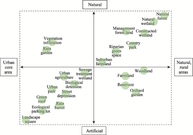
Fig. 1 The blue-green spaces along natural-to-artificial gradients
From the perspective of urban and rural areas, the blue- green space is the link between humans and nature, and plays an extremely important role in the construction of the human living environment. The connotation of BGS includes “ecology”, encouraging natural processes rather than engineering solutions, the water environment and water ecological protection; “Green”, the green infrastructure composed of natural elements for the construction and development of a low environmental impact; “Connection”, connecting people with nature, social communities and biological habitats; “Openness”, the attribute of public service, the inclusiveness towards different groups in the society, and the use and accessibility of the public; “Diversity”, the mixed use of multiple objectives; and “Attraction”, the preservation of historical memory and cultural identity.

2.3 Review of related literature on blue-green space planning

The BGS is suitable for a diverse city land use area, including the high density of the city, low-density suburban areas, industrial and agricultural land areas, and the natural ecology area. The BGS planning is a kind of adaptive action, aiming to create a resilient area in order to fight the internal and external pressures of the urban system, especially regarding the effects of climate change. The related planning of BGS involves various planning types in the macro, meso, and micro scales (Table 1).
Table 1 The current related planning of blue-green space at the three spatial scales
Scale Related planning Objective Content or method
Macro scale Watershed planning Pursue healthy urban watersheds, healthy hydrology, habitat, water quality, and the maintenance of diverse ecological functions and processes Focus on the relationship between land use, land cover, water movement and storage, and water quality. Establish a vision, goals, strategies, and actions
Riparian ecosystem management Protect major ecological services and restore natural resources while meeting current and future social, economic, political and cultural needs Includes adaptive management, natural resource management, strategic management, and command and control management
Ecological corridor planning Integrate the spatial-temporal pattern of urban development and ecological resources, recreation site construction, historical preservation, and natural ecological maintenance, etc. Corridor construction, determine spatial elements, patch morphology, corridor length and width, characteristics and functions, and construction guidelines
Meso scale Green open space Compound functions including wildlife habitat, landscape quality, watershed protection, recreation and quality of life functions Propose planning classification, develop quantitative standards, and formulate guidelines for the design of various service levels and facilities
River greenway planning Integrate natural and cultural resources, strengthen links between urban and rural areas, form green networks, and provide comprehensive functions The planning includes greenway selection, the tour system, greenway greening and greenway facilities, greenway design guidance, etc.
Urban water system planning Water safety guarantees, water quality targets, water landscape construction, water culture protection, etc. Consider population density, surface conditions, water resources, water system spatial layout, functional orientation, land coordination, etc.
Micro scale Riparian ecological restoration Consider the health and sustainability of the riparian ecosystem, combine water conservancy engineering with ecology, and perform self-repair functions Choose vegetation suitable for the riparian area and design the landscape, roads, greenery and recreational facilities
Water-storm
management
Provide appropriate space for rainwater storage and purification in the surrounding areas Vertical design of roads and greenways, low impact facility layout combined with the grey infrastructure
Waterfront park design Apply ecological design principles and methods, consider ecology, landscape, flood control and other multiple functions Design and treatment of the plant community, landscape architecture, road paving system and revetment in the green space
The related planning types at the macro scale include watershed planning, riparian ecosystem management, ecological corridor system planning, etc. These plans focus on the development of integrated vision goals, strategies and management policies in the upper, middle and lower watershed portions of rural areas (Scott, 2006). They also focus on spatial functional structure planning by integrating the spatial-temporal patterns of urban and rural development and ecological resources (Xu et al., 2015), and the ecological function zoning of ecological corridors (Zhang et al., 2018).
The related planning types at the mesoscale include green open space planning, river greenway planning, urban water system planning, etc. These planning efforts focus on urban or suburban areas, emphasizing the preservation of natural attributes of the blue-green resources. They are combined with adjacent urban systems to form open space systems (Fang and Wu, 2015), providing urban residents with environmental education, leisure and recreation, fitness activities and other functions (Li and Jiang, 2014). The protection, connection and restoration of the network structure of the blue-green corridors linking urban and rural areas are also emphases of the planning at the mesoscale (Li, 2018).
The related planning types at the micro-scale include ecological restoration, storm water management, waterfront park design, etc. These planning efforts focus on the BGS design under multi-objective requirements, such as landscaping, recreation and environmental improvement (Zhu et al., 2018), storm-water management, restoration of the habitat environment, and buffer width and function (Andrea et al., 2017; Jin et al., 2018).
Facing the effects of climate change and the ecological environmental problems from urbanization, urban-rural resilience has been recognized as a new goal of blue-green space planning, to enhance the adaptability of the city in the face of sudden climate disasters. The blue-green space pays more attention to the integration of ecological and social values, in order to improve the comprehensive efficiency of urban ecosystem services. The blue-green space and its ecosystem services have obvious spatial heterogeneity, and the utilization of blue-green space presents the situation of mismatches between its spatial patterns and functional demands (Yu et al., 2020).
The blue-green space planning should systematically integrate the differentiated ecological characteristics and social demands. According to the features of the natural attributes and adjacent construction appeals, the differentiated regulation based on the urban-rural transect could be an efficient method to adopt. The technical points include the differentiated function orientation, land spatial layout, establishment of control indicators, planning strategies and construction guides of each zone, so as to form the scientific planning approach for both protection and utilization.

3 The conceptual framework of blue-green space integrated planning

3.1 The integrated planning concept under urban-rural resilience goals

The functions of blue-green spaces cross administrative boundaries. In addition to being defined by discrete, multifunctional sequences of characteristic elements, they are also more determined by spatial attributes. The existing blue-green space planning has a disordered scale and hierarchy system, pursues single functional goals, and suffers from unbalanced value orientation, uncoordinated protection and utilization, and the mismatched environmental characteristics of urban and rural areas. As a result, the overall service function of blue-green space is low. Therefore, it is urgent to solve this problem with integrated planning ideas.
The related theories of ecology and urban-rural ecological planning are referenced and integrated to support the integrated planning idea. The various theories and methods each have different applicable spatial levels and key application steps in the study of blue-green space planning (Table 2).
Table 2 The theories and methods that can support the study
Supporting theory Specific theory Main methods Applicable spatial levels Key application steps
The theory of
ecology
Watershed
(river) ecology
Watershed planning method, river continuum Urban-rural area ▪ Use watershed as an ecosystem analysis unit
▪ Longitudinal connection and maintenance of natural processes of blue-green corridors
Urban ecology Assessment of
supply-demand of
ecosystem services, tradeoff analysis of
ecosystem
Urban-rural area,
urban-town district
▪ Supply-demand assessment of ecosystem service functions
▪ Value tradeoff of the dominant functional orientations of different areas
▪ Analysis of ecological correlations between blue-green space and construction space
Landscape ecology Landscape ecological network Urban-rural area,
urban-town district
▪ Scale effect is applied to construct planning spatial hierarchy
▪ Construction of composite functional system of the blue-green space
Interfacial ecology Ecological interface
design
Street-site ▪ Control of social and ecological attributes of blue-green spaces
Theory of urban and rural ecological planning Eco-urbanism Ecological flow system design Urban-town district, street-site ▪ Blue-green space ecological design of general urban areas and urban core areas
New urbanism Urban-rural transect, smart code Urban-rural area,
urban-town district, street-site
▪ The transect is used for the function planning and space design of blue-green space
▪ The smart code is used to manage the construction of spatial boundaries and the index control
Urban-rural
ecological planning in mountainous areas
Local ecological wisdom, ecological planning and design Urban-rural area,
urban-town district, street-site
▪ The analysis and cognition of the blue-green space, especially for its resilience and adaptability
▪ Protection, restoration and construction of mountain areas
The integrated planning idea fits in with the goal of urban-rural resilience, including the value orientations of resilience such as “Complexity”, “Consistency”, “Systematic”, “Differentiation” “Coordination”, etc. (Fig. 2). The integrated planning of the BGS under the goal of urban-rural resilience should coordinate the development of urban and rural regional space in terms of spatial scope. On the timeline, attention should be paid to the benefits of each stage in the near, medium and long term, and the resilience to future obstacles and uncertainties of future development. It is necessary to balance the ecological and social benefits of urban and rural areas in terms of target orientation.
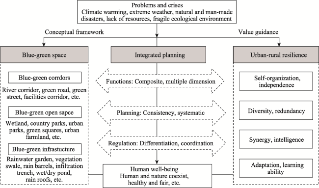
Fig. 2 The integrated planning concept linking the blue-green space and urban-rural resilience
The integrated planning of the BGS should follow its in herent natural ecological characteristics and integrate the service demands of the construction and development of adjacent land. The functional setting and layout of blue-green space not only pay attention to the internal adaptation to the evolution of the natural ecosystem, but alsoconsider the related environmental impacts and urban-rural functional demands in the external form. The integrated planning not only ensures the healthy operation of the watershed ecosystem, but also improves the overall service functions of related construction units, so as to minimize the impact of urban and rural construction on the natural environment and derive higher social and economic values.

3.2 The conceptual framework of blue-green space integrated planning

Blue-green space integrated planning covers three aspects: the identification and assessment of the blue-green resources, multi-scale blue-green space overall layout (blue-green corridor network construction, blue-green open space configuration, blue-green infrastructure layout), and the differentiated regulation based on the urban-rural transect. All aspects of the work content are closely linked, and have dynamic feedback and timely adjustments, so as to obtain the maximum comprehensive benefits of the blue-green space (Fig. 3).
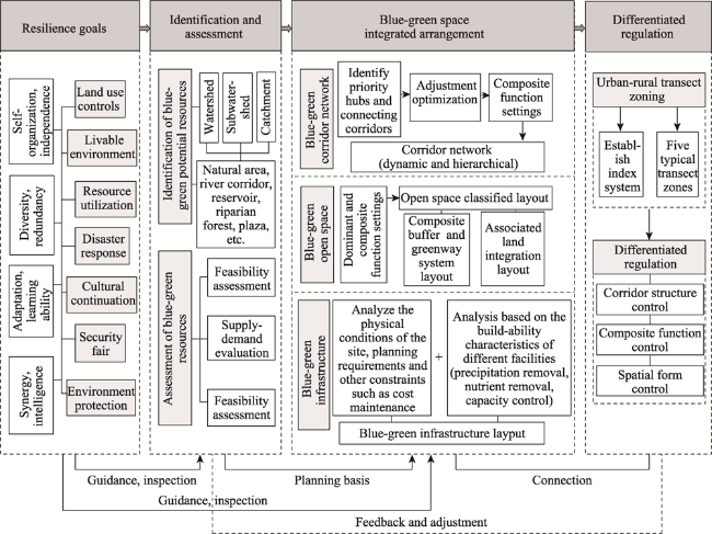
Fig. 3 The conceptual framework of blue-green space integrated planning

4 Practicable approach for blue-green space planning under urban-rural resilience goals

4.1 Identification and assessment of blue-green resources guided by urban and rural resilience

4.1.1 Identification of potential blue-green space resources

The identification of potential blue-green space resources, ecological supporting processes such as hydrological flows, water tributaries and infiltration, topographic features, soil types, and groundwater level, are key consideration factors for the identification of blue-green space and the demonstration of its hydrological performance. With a focus on intrinsic connectivity, the storage and permeability components can be linked by linear water conversion components, and if some blue-green space components reach their capacity limits, other components can take over to support their catchment functions. At the regional and district levels, GIS and other tools are used to identify relevant data. At the site level, the micro-catchment identifies the potential space of the blue-green infrastructure through a number of urban morphological indicators (such as penetration rate of the ground, depth of building retreat, form of road greening, vegetation cover, topographic characteristics, etc.) which are closely related to the spatial and functional characteristics of the blue-green infrastructure. The blue-green resources in urban-rural areas could be large natural areas beside hydrologic passageways, river corridors, reservoirs, riparian forest belts, residential courtyards, open water bodies, public spaces or green squares (Table 3).
Table 3 The identification list of blue-green space resources and main functions
Hydrological unit Blue-green space Potential main functions
Watershed
(Urban-rural areas)
Natural areas Flora and fauna habitats, water purification
River corridor network Wildlife migration, pollution protection, water purification
Country parks Recreation and tourism, flora and fauna habitats
Large lakes and wetlands Waterhead area, flora and fauna habitats, pollution protection
Sub-watershed
(Urban-town districts)
Small wetland Pollution protection, flood regulation
General lakes, reservoirs Water storage, flood regulation
Urban parks Air purification, environmental education, recreation and entertainment, fitness, landscape appreciation
Urban greenway and street Recreation and entertainment, fitness
Riparian woodland Pollution protection, banks stabilization, wildlife migration
Residential green areas Entertainment, landscape appreciation, air purification
Catchment
(street-sites)
Residential courtyard Recreation and landscape appreciation
Ponds, swales Water storage, stormwater retention and regulation
Green roofs Mitigate heat island effect, stormwater retention
Roadside greenbelt Windproof, solid dust, landscape appreciation
Green square Recreation and landscape appreciation

4.1.2 Supply-demand and feasibility evaluation of blue-green space

There is a complex interaction between the supply and demand as well as the coordination and tradeoff of the complex functions of blue-green space (Fig. 4). By evaluating the spatial scope and action intensity of the subjects of the BGS composite function, we can understand the characteristics of the supply-demand relationship under different spatial scales, and different space and time nodes of urban and rural areas. By analyzing the supply-demand influence mechanism of land use type and intensity on the composite functions, the function orientations and target orientations of blue-green space under different spatial and temporal nodes are determined. At the same time, understanding the synergy and tradeoff mechanisms between the complex functions of the blue-green space can help us to better manage the relationship between the composite ecological service functions, so as to establish the dominant and secondary functions of the blue-green space at different locations in the urban and rural areas.
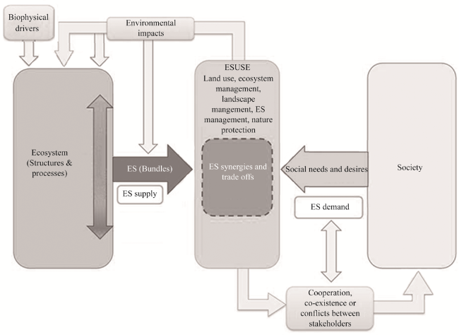
Fig. 4 The supply and demand of the composite ecosystem service function, and the balance mechanism

Note: ES: Ecosystem service; ESUSE: Ecosystem service use. Source from Turkelboom et al., 2015.

In order to effectively operate specific target functions, a feasibility assessment is needed for the protection, transformation, management and experience of blue-green space resources. A feasibility assessment includes both site feasibility assessment and practical feasibility assessment. Site feasibility assessment requires a large amount of basic fieldwork data to understand the site characteristics, including current land use characteristics (intensity/ownership), soil and water pollution, and underground structural characteristics (Fryd et al., 2013). The comprehensive benefits of blue-green space have been evaluated by a comprehensive evaluation of ecological service characteristics and the hydrologic connected network. Practical feasibility evaluation requires collecting ecological data for the watershed, including the degree of soil infiltration and topography conditions (such as slope, ground water, soil type, etc.), and the climatic conditions that influence evaporation and cooling processes (e.g., solar radiation and temperature). The BGS ecological performance is affected by the ecological characteristics of the watershed (Ghofrani et al., 2016).

4.2 Blue-green space planning at multiple scales

Blue-green spaces have different planning emphases at different spatial levels (Fig. 5). At the urban and rural watershed level, the planning focuses on the construction of the blue-green corridor network; at the urban area level, the planning focuses on the configuration of the blue-green open space; and at the street and site level, the planning focuses on the layout of blue-green infrastructure. These three spatial levels of planning provide links between the upper and lower guidance in the value orientation, functional positioning, goal setting, space design and control implementation and the other planning content.
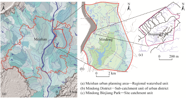
Fig. 5 The three planning scales of blue-green space in Meishan City, Sichuan Province. (a) Meishan urban planning area— Regional watershed unit; (b) Mindong District—Sub-catchment unit of urban district; (c) Mindong Binjiang Park—Site catchment unit.

4.2.1 Urban-rural regional level—blue-green corridor network construction

The goal of planning at the urban and rural areas level is the construction of the blue-green corridor network based on the hydrological ecological suitability. Each sub-watershed contains some isolated ecological elements with various static and dynamic characteristics, which could be functionally connected by a linear structure. The “blue-green corridor network” is formed, providing multiple compound functions and aiming to increase the connectivity between the natural and semi-natural areas and between the urban built-up areas and natural areas.
The construction process of the blue and green corridor network is as follows: Identify priority protective ecological area to establish an ecological hub; identify corridor space through the best ecological path; overlay different corridor types; form the ecological network after adjustment and optimization and the composite functions are set up (Xing et al., 2017) (Fig. 6). Blue and green corridor networks need to increase their connectivity at different spatial scales, including micro-scale connections within the catchment units, meso-scale connections between secondary catchment units, and macro-scale connections across the watershed units.
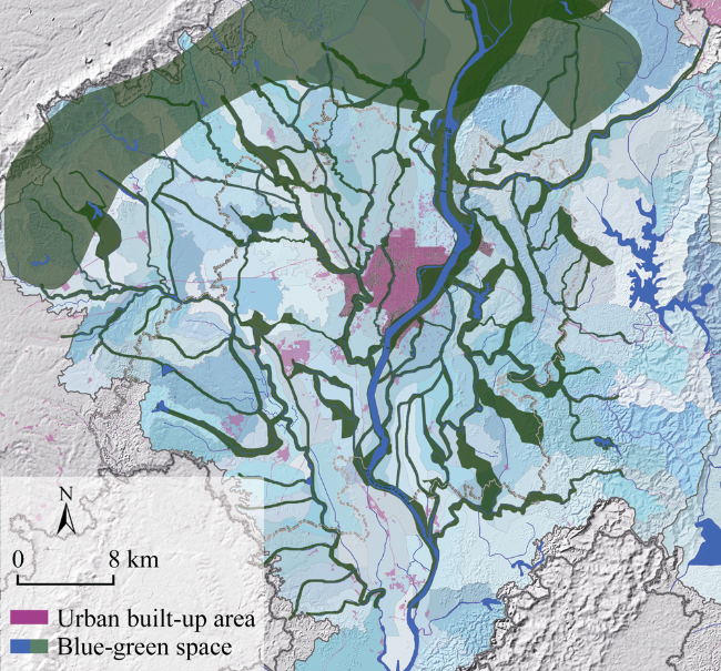
Fig. 6 Blue-green corridor network of Meishan in the urban and rural area
The expected results should be an increase in the accessibility to major natural green areas, control of flood crises, supply of ecosystem services (climate regulation, biodiversity, water purification, etc.), and improvement of the livability for urban-rural residents along the corridors.

4.2.2 Urban and town level—blue-green open space configuration

The planning of the blue and green open space needs to consider the integration of the construction area and the natural environment area. Firstly, combined with the characteristics of current land use and its environmental impacts, the characteristics and mechanisms of water environmental impacts caused by associated land use are recognized, and the land use that is more relevant is adjusted, such as the scattering of commercial residential land which is at key points in and out of rivers to reduce domestic wastewater pollution. It is necessary to conduct zoning design, guidance and control of the different types, sizes, layouts, forms and plant species configurations of the blue-green space to improve the land efficiency and composite functions.
Forestland has the function of conserving water sources and purifying water quality. Therefore, the BGS planning should be combined with surrounding forestland planning to form natural buffer zone and water resource conservation areas. The blue-green composite buffer zone is organized by forest land, water bodies and a natural discharge mode space carrier. According to the level of protection, the composite buffer is divided into riverside area, central area and external area, and control is conducted from inside to outside with different degrees of strictness (Schueler, 1995) (Fig. 7).
Fig. 7 The blue-green space layout (left) and composite buffers (right) in Mindong area, Meishan City.

Note: Source from “Water system planning of Mindong”, Schueler, 1995.

The collection and utilization of rainwater resources in the construction area will be combined with the construction of the vegetation landscape, so as to reduce the cost of landscape operations, to restore the ecological environment of the water system and maintain its ecological service functions, and to provide the comprehensive functions of the BGS in terms of ecological support, environmental protection, landscape shaping, and social and cultural activities.

4.2.3 Street and site level—blue-green infrastructure allocation

The integration of the design of blue-green infrastructure with architecture, site and landscape should be fully considered. Through the organic combination of natural and artificial elements, the environmental impact of construction can be reduced in the process of natural work.
In the past, the allocation of stormwater facilities was often isolated from the natural or urban landscape structure and urban layout, which divorced from the natural hydrological processes and urban morphological dynamics. Combined with the natural environment, the dispersed stormwater management measures are adopted. By analyzing the physical condition of each site, planning requirements and the cost of maintenance and other restrictions, the allocation is conducted combined with the suitability of different stormwater infrastructure components, such as rain gardens, rain barrels, street depressions, vegetation infiltration, permeable parks, wastewater wetlands, etc. (Figs. 8, 9).
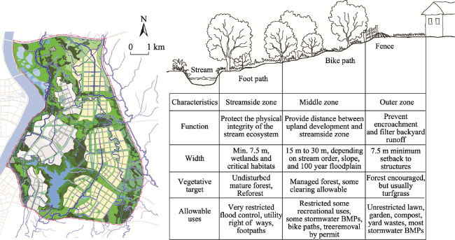
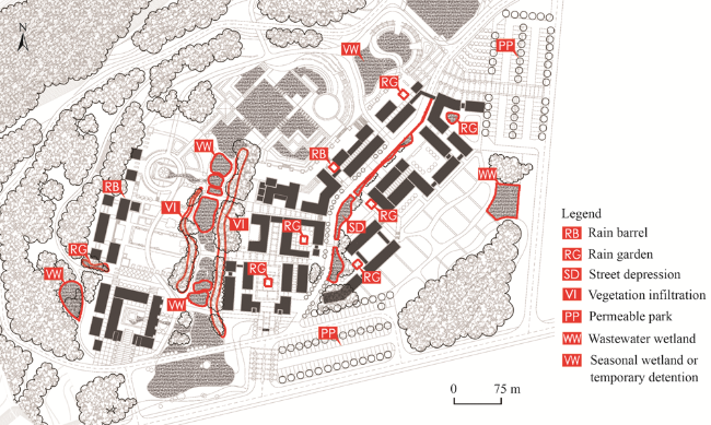
Fig. 8 The stormwater management system in a riparian site of Mindong area, Meishan City.
Fig. 9 The blue-green infrastructure setting in a riparian site of Mindong area, Meishan City.

4.3 Differentiated regulation based on urban-rural transects

4.3.1 Urban-rural transects

In urban and rural areas, the natural environmental features of the blue-green space differ greatly due to the variations of topography and landforms, especially the steep drop from upstream to downstream along the river, which leads to a sharp change in the features of the blue-green space, and the land development features and ecological service functions are also quite different. The blue-green space begins from natural source areas and passes through agricultural production areas, towns and cities along the way. The issues of land ownership and utilization are chaotic and complicated, and the construction and development demands of related lands are also variable. Therefore, the previous extensive demarcation method of “one size fits all” should be abandoned. The index system should be established according to the characteristics of the urban and rural ecological environment and corresponding construction and development goals and appeals, so as to divide the urban and rural transect zoning which is the basic spatial zoning unit for the differentiated management of the urban-rural BGS (Table 4). Urban-rural transects are usually divided into five typical zones: nature reserve (T1), rural agricultural area (T2), urban fringe area (T3), general urban area (T4), and urban core area (T5) (Fig. 10).
Table 4 The urbanization attribute index of urban-rural transect zoning
Index Nature preserve
(T1)
Rural agricultural area (T2) Urban fringe area
(T3)
General urban area (T4) Urban core area
(T5)
Population density Low Lower Middle Higher High
Road density Low Lower Middle Higher High
Proportion of urban construction land Low Lower Middle Higher High
Proportion of industrial and mining land in cities and towns Low High Higher - -
Proportion of village construction land Low High Higher - -
Proportion of impermeable cover Low Lower Middle Higher High
Proportion of agricultural land Lower High Middle Lower -
Urban functional structure in the urban and rural master plan Tourism type Agricultural type Industry, Agricultural
type
Comprehensive type Comprehensive type
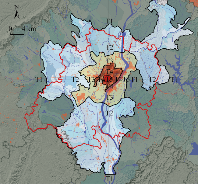
Fig. 10 Urban-rural transect zoning of Meishan City

Note: T1= Nature reserve; T2= Rural agricultural area; T3= Urban fringe area; T4= General urban area; T5= Urban core area.

4.3.2 Differentiated regulation based on urban-rural transects

On the basis of urban-rural transect zoning, the blue-green space shall be managed and controlled in the different zones, including the overall corridor structure control, composite function control and spatial form control, which should be combined qualitatively and quantitatively with the combination of “structure”, “form” and “scale”, so as to ensure the maximum comprehensive benefits of the blue-green space system in the urban and rural areas (Tables 5, 6).
Table 5 Overall index control of riparian green space at the urban-rural level in Meishan City
Urban-rural transect River corridor width (m) River network density (km km-2) Forest cover ratio (%) Biological
abundance
Proportion of impermeable cover (%) Water area ratio (%)
Nature preserve (T1) 200 0.4 85 0.8 5 2-5
Rural agricultural area (T2) 100 0.3 50 0.5 10 3-8
Urban fringe area (T3) 50 0.2 40 0.4 20 8-12
General urban area (T4) 30 0.1 30 0.3 35 3-8
Urban core area (T5) 10 0.05 20 0.2 50 2-5
Table 6 The regulation and design guide for blue-green space land use based on transect zoning in Meishan City
Urban-rural transect Land use Area ratio (%) Form, scale and layout of green space Vegetation allocation requirements Schematic diagram
Nature
preserve
(T1)
T1-EG1
T1-EG2
>90 Large and concentrated ecological green patch size, try to keep inner edge ratio of the patch high Natural native arbor vegetation, canopy density >0.8
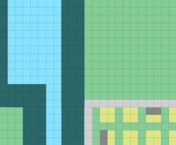
T1-EG3 <5 Higher forest network density for farmland protection, wider roads and river shelterbelts Evergreen tree > deciduous tree > shrubs > grass
T1-EG4 >10 Less, smaller, and dispersed patches of agriculture and forestry Proportion of native crops in arbor category > 80%
Rural agricultural area
(T2)
T2-EG1
T2-EG2
>50 Concentrated ecological green patch size, try to keep inner edge ratio of the patch high Natural native arbor vegetation, canopy density >0.7
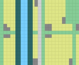
T2-EG3 5-10 Appropriate forest network density for farmland protection, and roads and river shelterbelts Deciduous trees = evergreen trees > shrubs > grass
T2-EG4 >30 Appropriate farmland scale, agro-forestry Mainly for grasses, herbaceous crops
Urban fringe area (T3) T3-EG1
T3-EG2
30-50 Relatively concentrated ecological green patch size, high inner edge ratio of patch Natural and semi-artificial vegetation, canopy density >0.6
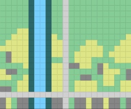
T3-EG3 30-50 Appropriate forest network density for farmland protection, and roads and river shelterbelts Deciduous trees > evergreen trees > shrubs > grass
T3-EG2 10-30 Concentrated and dispersed farmland patch, agro-forestry Mainly for grasses, herbaceous crops
General urban area (T4) T4-G1 >60 Central large park is combined with the green space beside the small scattered street Semi-artificial vegetation community, canopy density > 0.4
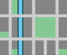
T4-G2 10-30 Appropriate roads and river shelterbelts Evergreen trees > deciduous trees > shrubs > grass
T4-G3 5-15 Large area, relatively high green coverage rate Artificial vegetation
T4-XG 5-15 Meet associated land use needs Artificial vegetation
Urban core area (T5) T5-G1 20-40 Small dispersed green space, strengthen the greening of both sides of streets, squares and sites Artificial vegetation community, canopy density > 0.2
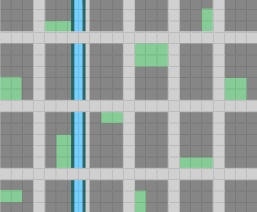
T5-G3 30-50 Small area, relatively lower green coverage rate Evergreen trees > deciduous trees > shrubs > grass
T5-XG 5-15 Meet associated land use needs Artificial vegetation

Note: G1 (park green space), G2 (protective green space), G3 (square land), XG (affiliated green space), EG (regional green space) are the classification standards of urban green space (CJJ/T85-2017). EG is subdivided into EG1(scenic recreation green space), EG2 (ecological conservation green space), EG3 (regional protective green space), and EG4 (agriculture and forestry production green space).

5 ConclusionsAcknowledgements

Under the background of climate change and urbanization, planners have to integrate blue-green space resources into an integrated planning strategy in order to design an urban and rural living environment that adapts to climate change and its impacts (Xing et al., 2015). From the resilience perspective of urban and rural areas, the blue-green space is the implementation structure system which can be used as a way to moderate and provide adaptive interactions for eliminating the confrontations, and reduce the negative influences. Blue-green space integrates the existing ecological pattern and process of knowledge into the management practice and control of structural design in order to generate the hydrological ecological performance. The performance and function of the urban ecosystem can also be maximized over time, which shapes the symbiotic environment of humans and nature.
This paper elaborates the concept and connotation of blue-green space, its functional characteristics and its interactive relationship with the urban-rural resilience value. Practicable approaches of blue-green space planning are constructed at multiple scales, ranging from identification and assessment of blue-green space resources to the construction of the blue green corridor network, the blue-green open space configuration and the blue-green infrastructure allocation.
This research is also supported by “Team Building Project for Graduate Tutors in Chongqing”.
[1]
Andrea N D, Kenton L S, Christopher D B, et al. 2017. Long-term response of stream and riparian restoration at Wilson Creek, Kentucky, USA. Ecological Restoration, 35(3): 246-254.

DOI

[2]
Berg P G, Ignatieva M, Granvik M, et al. 2013. Green-blue infrastructure in urban-rural landscapes: Introducing resilient citylands. Nordic Journal of Architectural Research, (2): 11-37.

[3]
Duany A, Talen E. 2002. Transect planning. Journal of the American Planning Association, 68(3): 245-266.

DOI

[4]
Fang J, Wu C Z. 2015. Contents and case study of open space planning in the USA. City Planning Review, 39(5): 76-82. (in Chinese)

[5]
Fryd O, Backhaus A, Birch H, et al. 2013. Water sensitive urban design retrofits in Copenhagen-40% to the sewer, 60% to the city. Water Science and Technology, 67(9): 1945-1952.

DOI PMID

[6]
Ghofrani Z, Faggian R, Sposito V. 2016. Designing resilient regions by applying blue-green infrastructure concepts. Sustainable City, 204: 493-505.

[7]
Ghofrani Z, Sposito V, Faggian R. 2017. A comprehensive review of blue-green infrastructure concepts. International Journal of Environment and Sustainability, 6(1): 15-36.

[8]
Gill S E, Handley J F, Ennos A R, et al. 2007. Adapting cities for climate change: The role of the green infrastructure. Built Environment, 33(1): 115-133.

DOI

[9]
Helen E A, Richard J H. 2004. Resilience, adaptive capacity, and the “lock-in trap” of the western Australian agricultural region. Ecology and Society, 9(1): 3.

[10]
Holling C S. 1973. Resilience and stability of ecological systems. Annual Review of Ecology and Systematics, 4(1): 1-23.

DOI

[11]
Hung Y Y, Aquino G, Waldheim C. 2012. Landscape infrastructure: Case studies by SWA. Basel, Switzerland: De Gruyter.

[12]
Jin Y F, Song M Y, Wu Y B, et al. 2018. Ecological restoration of the Riparian Zone in Changsha Baxizhou Central Park. Journal of Chinese Urban Forestry, 16(6): 40-43, 57. (in Chinese)

[13]
Lawson E, Thorne C, Ahilan S, et al. 2014. Delivering and evaluating the multiple flood risk benefits in blue-green cities: An interdisciplinary approach. Flood Recovery, Innovation & Response, 184(4): 113-124.

[14]
Li L, Jiang Y F. 2014. Progress on urban river greenway's theory and practice of overseas and domestic research. China Population, Resources and Environment, 24(S1): 309-312. (in Chinese)

[15]
Li J. 2018. Exploration on urban waterway planning methodology from the perspective of sponge city. City Planning Review, 42(6): 100-104. (in Chinese)

[16]
Li T Y. 2017. New progress in study on resilient cities. Urban Planning International, 32(5): 15-25. (in Chinese)

DOI

[17]
Ratko R, Boris R, Velisa Miljanovic, et al. 2013. Blue-green corridors as a tool for mitigation of natural hazards and restoration of urbanized areas: A case study of Belgrade City. Spatium, (30): 18-22.

[18]
Sara M, Joshua P N, Melissa S, et al. 2016. Defining urban resilience: A review. Landscape and Urban Planning, 147: 38-49.

DOI

[19]
Schueler T. 1995. Site planning for urban stream protection. Washington DC, USA: Center for Watershed Protection(CWP).

[20]
Scott T. 2006. Ecology and management of riparian ecosystems. Ecology, 87(2): 529. DOI: 10.1890/0012-9658(2006)87[529:EAMORE]2.0.CO.2.

DOI

[21]
Susan B. 2007. Sustainable development as symbolic commitment: Declaratory politics and the seductive appeal of ecological modernisation in the European Union. Environmental Politics, 16(2): 297-317.

DOI

[22]
Thomas K, Littlewood S. 2010. From green belts to green infrastructure? The evolution of a new concept in the emerging soft governance of spatial strategies. Planning, Practice & Research, 25(2): 203-222.

[23]
Turkelboom F, Thoonen M, Jacobs S, et al. 2015. Ecosystem service trade-offs and synergies. In: Potschin M, Jax K (eds.). Ecosystem services reference book. Helsinki, Finland: Openness Reference Book.

[24]
Wu Y, He X S, Yang L. 2020. Compilation conception of city and county level blue-green space system specialized planning under national territory spatial planning system. Landscape Architecture, 27(1): 30-34. (in Chinese)

[25]
Xing Z, Yu Q, Gu Y Y, et al. 2019. Research on green space planning methods based on urban-rural transect zoning. City Planning Review, 43(4): 24-40. (in Chinese)

[26]
Xing Z, Yu Q, Zhou Q, et al. 2017. E type land corridor planning. Planners, 33 (4): 18-25. (in Chinese)

[27]
Xing Z, Yu Q, Jin Q. 2015. Low environmental impact planning and design. Chinese Landscape Architecture, 31 (6): 51-56. (in Chinese)

[28]
Xu Y Q, Sun Y, Shao Y W. 2015. Urban ecological corridor planning based on the rainwater footprint of hilly terrain: A case study of the master plan of Jianshi County. City Planning Review, 39(9): 82-86. (in Chinese)

[29]
Yu Q, Xing Z, Zhou Q F, et al. 2020. Mapping supply-demand of riparian ecosystem service for riparian greenspace planning on multiple spatial scales. China City Planning Review, 29(4): 6-17.

[30]
Zhang Y L, Li X, Tian Y. 2018. Study on ecological function zoning in the Municipal Administrative Area based on the landscape ecology source-sink theory: A case study of Tongliao, Inner Mongolia. Acta Ecologica Sinica, 38(1): 65-72. (in Chinese)

[31]
Zhu L Q, Peng F, Gao C. 2018. Climate change adaption and urban resilience: A case study of landscape design research about South Bay Park in Hudson, USA. Chinese Landscape Architecture, 34(4): 41-46. (in Chinese)

Outlines

/