
Journal of Resources and Ecology >
Evaluating the Ecological Security of Land Resources based on Multi-source Data in the Altay Region of China
|
YE Hui, E-mail: xiaohuihui_ye@foxmail.com |
Received date: 2021-04-15
Accepted date: 2021-06-11
Online published: 2021-11-26
Supported by
The Key Program of Basic Research of Yunnan Province, China(2019FA017)
The Multi-Government International Science and Technology Innovation Cooperation Key Project of National Key Research and Development Program of China(2018YFE0184300)
The Postgraduate Scientific Research Fund Project of Yunnan Provincial Department of Education(2021Y501)
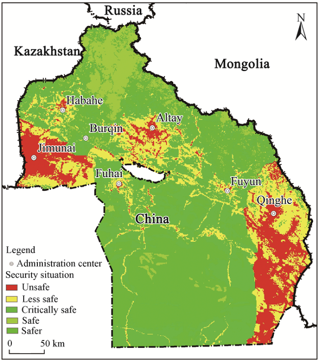
As a material carrier contributing to human survival and social sustainable development, the ecological environment is declining in its integrity and overall health. With the rapid development of society and economy, it is currently very necessary to carry out ecological security evaluation research to provide scientific guidance and suggestions for the construction of ecological civilization and the harmonious co-existence between man and nature. Taking Altay region as the research area, this paper collected and integrated regional geological, geographical, cultural, socio-economic, and statistical data, as well as previous research results. Combined with DPSIR and EES framework model, the evaluation index system of land resource ecological security in Altay region was constructed by using the analytic hierarchy process, entropy method and linear weighted summation function method. Using this index system, the evaluation research work was carried out to determine the current state of the security situation and the major threats which should be addressed. (1) The overall ecological security situation of Altay region was relatively safe, while the local ecological security situation was relatively fragile. Among them, the areas with safe and safer ecological environment accounted for 38.72%, while the areas with critically safe status accounted for 30.83%, and the areas with a less safe and unsafe environment accounted for 30.45%. In terms of spatial characteristics, the areas with unsafe ecological environment were mainly distributed in the west and east of the study area, while the areas with good ecological environment were distributed in the north of the study area. (2) Large-scale mining activities, frequent geological disasters, large-scale reclamation and long-term cultivation of arable land, and long-term large-scale grazing activities resulting in the destruction of grassland and vegetation were the main factors leading to the prominent ecological security problems of land resources in the Altay region. Therefore, in the process of the continuous development of the urban economy, we should pay more attention to the harmony between man and nature, and also actively and effectively advocate and implement certain policies and measures, such as returning farmland to forest, returning grazing land to grassland and integrating the mining of mineral resources.
YE Hui , BAI Die , TAN Shucheng , SHAO Dajiang , WANG Jinliang . Evaluating the Ecological Security of Land Resources based on Multi-source Data in the Altay Region of China[J]. Journal of Resources and Ecology, 2021 , 12(6) : 757 -765 . DOI: 10.5814/j.issn.1674-764x.2021.06.004
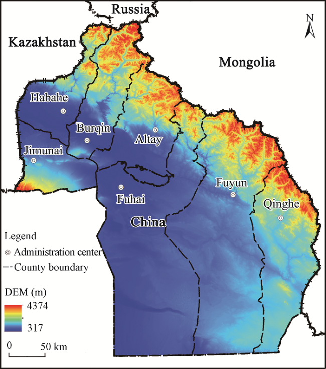
Fig. 1 Map of the location of Altay |
Table 1 Basic data for the study area |
| Serial number | Category | Source name | Specifications | Data source |
|---|---|---|---|---|
| 1 | Geological | Geological map of Xinjiang Uygur Autonomous Region | 1:500000 | National Geological Data Center (http://www.ngac.cn/) |
| 2 | Geological structure distribution map of Xinjiang Uygur Autonomous Region | 1:500000 | ||
| 3 | Regional geomorphologic map of Xinjiang Uygur Autonomous Region | 1:500000 | ||
| 4 | Regional geology of Xinjiang Uygur Autonomous Region | 1:500000 | ||
| 5 | Remote sensing data | Landsat 8 remote sensing data | Spatial resolution 30 m | Geospatial data cloud (http://www.gscloud.cn/) |
| 6 | NDVI (Vegetation coverage) | Spatial resolution 30 m | ||
| 7 | Geographic data | DEM (Digital elevation) | Spatial resolution 30 m | |
| 8 | Slope | Spatial resolution 30 m | ||
| 9 | Types of land use | Spatial resolution 30 m | ||
| 10 | Basic geography of Xinjiang Uygur Autonomous Region | Vector data | ||
| 11 | Statistical data | Xinjiang Uygur Autonomous Region statistical yearbook | Released in 2019 | Bureau of Statistics, Xinjiang Uygur Autonomous Region (http://tjj.xinjiang.gov.cn/) |
Table 2 Evaluation index system for ecological security in Altay area |
| Target layer | Criterion layer | Element layer | Index layer | Index orientation | Entropy method weight | AHP weight | Comprehensive weight |
|---|---|---|---|---|---|---|---|
| Evaluation index system of ecological security | Driving force (D) | Environmental driving force (D1) | Proportion of construction land area (D11) | ‒ | 0.0362 | 0.0318 | 0.034 |
| Density of road network (D12) | ‒ | 0.0336 | 0.0335 | 0.03355 | |||
| Economic driving force (D2) | Per capital GDP (D21) | + | 0.0335 | 0.0336 | 0.03355 | ||
| Per capita disposable income (D22) | + | 0.0385 | 0.0326 | 0.03555 | |||
| Social driving force (D3) | Population density (D31) | ‒ | 0.0357 | 0.0335 | 0.0346 | ||
| Pressure (P) | Environmental pressure (P1) | Geological hazard density (P11) | ‒ | 0.0358 | 0.0312 | 0.0335 | |
| Cultivated land area above slope of 25 (P12) | ‒ | 0.036 | 0.0401 | 0.03805 | |||
| Economic pressure (P2) | Growth rate of investment in fixed assets (P21) | ‒ | 0.0368 | 0.0297 | 0.03325 | ||
| Environmental capacity (P22) | + | 0.0389 | 0.0395 | 0.0392 | |||
| Social pressure (P3) | Residential density (P31) | ‒ | 0.0458 | 0.0365 | 0.04115 | ||
| State (S) | Environmental state (S1) | Geological structure (S11) | ‒ | 0.0377 | 0.0365 | 0.0371 | |
| Rock character (S12) | ‒ | 0.0385 | 0.0379 | 0.0382 | |||
| Topographic slope (S13) | ‒ | 0.0431 | 0.0368 | 0.03995 | |||
| Economic state (S2) | Amount of land resources (S21) | ‒ | 0.0362 | 0.0313 | 0.03375 | ||
| Social state (S3) | Vegetation coverage index (S31) | + | 0.0379 | 0.0357 | 0.0368 | ||
| Green coverage rate (S32) | + | 0.0438 | 0.0317 | 0.03775 | |||
| Impact (I) | Environmental influence (I1) | Distance from water system (I11) | + | 0.0515 | 0.0253 | 0.0384 | |
| Distance from road (I12) | + | 0.0392 | 0.0316 | 0.0354 | |||
| Economic influence (I2) | Year-end deposits of residents (I21) | + | 0.0357 | 0.0426 | 0.03915 | ||
| Electric energy production (I22) | - | 0.0399 | 0.0338 | 0.03685 | |||
| Social influence (I3) | Forest and grassland area (I31) | + | 0.0395 | 0.0446 | 0.04205 | ||
| Per capita cultivated land area (I32) | + | 0.0385 | 0.0377 | 0.0381 | |||
| Response (R) | Environmental response (R1) | Annual rainfall (R11) | + | 0.0395 | 0.0376 | 0.03855 | |
| Annual average temperature (R12) | + | 0.0402 | 0.0341 | 0.03715 | |||
| Land use type (R13) | + | 0.0395 | 0.0401 | 0.0398 | |||
| Economic response (R2) | Public budget expenditure (R21) | + | 0.0416 | 0.0308 | 0.0362 | ||
| Social response (R3) | Available water resources (R31) | + | 0.0357 | 0.0411 | 0.0384 |
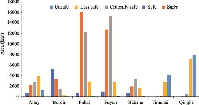
Fig. 2 Statistical status of land ecological security levels of counties in Altay region |
Fig. 3 Spatial distribution map of ecological security levels in Altay region |
Fig. 4 Distribution map of the spatial relationship between the spatial distribution of geological disasters and ecological security in Altay region |
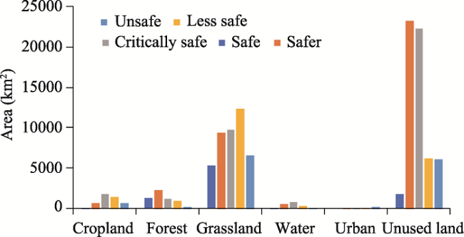
Fig. 5 Areas of the ecological security status categories for the different land use types |
| [1] |
|
| [2] |
|
| [3] |
|
| [4] |
FAO. 1997. Land quality indicators and their use in sustainable agriculture and rural development. Rome, Italy: Proceedings of the Workshop Organized by the Land and Water Development Division FAO Agriculture Department, 1: 5-10.
|
| [5] |
|
| [6] |
|
| [7] |
|
| [8] |
|
| [9] |
|
| [10] |
|
| [11] |
|
| [12] |
|
| [13] |
|
| [14] |
|
| [15] |
|
| [16] |
|
| [17] |
|
| [18] |
|
/
| 〈 |
|
〉 |
