
Journal of Resources and Ecology >
Estimation of Critical Rainfall for Flood Disasters in the Qinghai-Tibet Plateau
|
MA Weidong, E-mail: mwd0910@sina.com |
Received date: 2020-12-16
Accepted date: 2021-03-15
Online published: 2021-11-22
Supported by
The Key Research and Development Projects of the Ministry of Science and Technology of China(2019YFA0606900)
The Second Qinghai-Tibet Plateau Scientific Expedition and Research Program(2019QZKK0906)
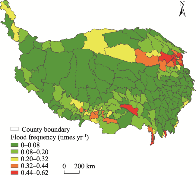
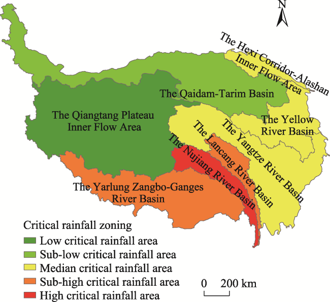
According to the results of The Second Comprehensive Scientific Expedition on the Qinghai-Tibet Plateau, the balance of solid and liquid water on the Qinghai-Tibet Plateau is disturbed, and a large amount of solid water, such as glaciers and perpetual snow, is transformed into liquid water, which aggravates the risk of flood disasters in the Plateau. Based on the historical flood disaster records of the Qinghai-Tibet Plateau, this paper analyzed the temporal and spatial distribution characteristics of the flood disasters in the Plateau, and estimated the critical rainfall for the flood disasters combined with precipitation data from the meteorological stations in each basin of the Qinghai-Tibet Plateau. The results show that most of the flood disaster events in the Plateau are caused by precipitation, and the average annual occurrence of flood disasters is more than 30 cases and their frequency is on the rise. The high frequency areas of flood disasters in the Qinghai-Tibet Plateau are mainly in the Hehuang Valley and the Hengduan Mountains area; the secondary high frequency areas are located in the valley area of South Tibet and the peripheral area of the Hehuang valley. Finally, we found that the highest critical rainfall value of flood disasters in the Qinghai-Tibet Plateau is in the southern area of the plateau, followed by the eastern and southeastern parts of the plateau, and the lowest values are in the central, western and northern parts of the Plateau.
Key words: Qinghai-Tibet Plateau; flood disaster; critical rainfall
MA Weidong , LIU Fenggui , ZHOU Qiang , CHEN Qiong , ZHANG Cungui , LIU Fei , LI Yanyan , ZHAO Pei . Estimation of Critical Rainfall for Flood Disasters in the Qinghai-Tibet Plateau[J]. Journal of Resources and Ecology, 2021 , 12(5) : 600 -608 . DOI: 10.5814/j.issn.1674-764x.2021.05.003
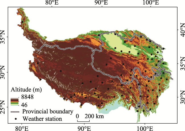
Fig. 1 Overview of the research area |
Table 1 Statistical table of rainfall for historical flood disasters in Bomi (Unit: mm) |
| Serial number | Date | P5 | P4 | P3 | P2 | P1 | Precipitation of the day |
|---|---|---|---|---|---|---|---|
| 1 | 1983-07-30 | 3.1 | 0.6 | 0.9 | 1.0 | 7.0 | 19.6 |
| 2 | 1984-08-06 | 0 | 2.8 | 3.6 | 0 | 0 | 16.4 |
| 3 | 1985-05-31 | 1.2 | 3.6 | 0 | 4.5 | 8.6 | 32.6 |
| 4 | 1985-06-17 | 0 | 1.1 | 3.1 | 18.0 | 20.7 | 18.7 |
| 5 | 1992-06-24 | 4.2 | 2.9 | 4.3 | 23.4 | 23.0 | 43.1 |
| 6 | 1999-09-02 | 11.1 | 1.0 | 2.9 | 2.7 | 17.9 | 16.8 |
| 7 | 2000-04-10 | 12.5 | 6.2 | 2.8 | 8.4 | 2.7 | 25.0 |
| 8 | 2006-09-12 | 7.2 | 0.1 | 11.1 | 17.0 | 5.2 | 34.9 |
| 9 | 2010-05-11 | 0.2 | 0.3 | 0.2 | 3.5 | 2.8 | 39.3 |
| 10 | 2010-06-07 | 0.7 | 5.1 | 7.8 | 16.5 | 10.6 | 37.5 |
Note: Pn represents the rainfall of the n-th day. |
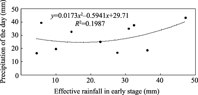
Fig. 2 Fitting results of critical rainfall for Bomi flood disasters |
Table 2 Key parameters of rainfall for historical flood disasters in the inland flow area of the Qiangtang Plateau (Unit: mm) |
| Serial number | County | Date | P5 | P4 | P3 | P2 | P1 | Precipitation of the day |
|---|---|---|---|---|---|---|---|---|
| 1 | Burang | 1990-08-08 | 0 | 0 | 3.1 | 0 | 0 | 15.3 |
| 2 | Shiquanhe | 1999-08-09 | 5.3 | 0 | 1.4 | 16.0 | 0 | 18.3 |
| 3 | Gerze | 1999-08-11 | 0 | 2.1 | 0.1 | 0 | 0 | 11.9 |
| 4 | Shiquanhe | 2000-07-28 | 7.0 | 0 | 0 | 0.5 | 0 | 16.1 |
| 5 | Bangoin | 2002-06-08 | 1.3 | 0 | 1.3 | 12.6 | 0.4 | 10.8 |
| 6 | Xainza | 2002-07-19 | 0 | 0 | 0.9 | 0 | 4.8 | 12.1 |
| 7 | Amdo | 2002-07-28 | 2.9 | 12.7 | 8.9 | 1.8 | 0.9 | 21.0 |
| 8 | Xainza | 2003-07-06 | 2.0 | 4.2 | 2.6 | 0.2 | 0.3 | 17.9 |
| 9 | Xainza | 2003-09-06 | 3.3 | 2.6 | 5.0 | 1.6 | 0 | 12.5 |
| 10 | Burang | 2006-07-31 | 4.7 | 1.8 | 1.5 | 0.2 | 0 | 12.4 |
| 11 | Gerze | 2010-08-12 | 0 | 0 | 0.3 | 3.9 | 16.9 | 17.5 |
Note: Pn represents the rainfall of the n-th day. |
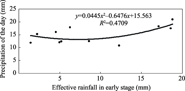
Fig. 3 Fitting results of critical rainfall for flood disasters in the inland flow area of the Qiangtang Plateau |
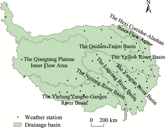
Fig. 4 The eight divisions of the Qinghai-Tibet Plateau Basin |
Fig. 5 Interannual variation of flood disaster frequency in the Qinghai-Tibet Plateau from 1961 to 2010 |
Fig. 6 Spatial distribution of flood disaster frequencies in the Qinghai-Tibet Plateau |
Table 3 Critical rainfall values of flood disasters at stations in the Yellow River Basin (Unit: mm) |
| Serial number | County | Critical rainfall value of flood disasters |
|---|---|---|
| 1 | Xining | 36.12 |
| 2 | Tongren | 28.06 |
| 3 | Qacuk | 24.49 |
| 4 | The other eleven stations | 24.46 |
Table 4 Critical rainfall values of flood disasters at stations in the Yarlung Zangbo-Ganges River Basin (Unit: mm) |
| Serial number | County | Critical rainfall value of flood disasters |
|---|---|---|
| 1 | Lazi | 34.11 |
| 2 | Lhasa | 37.92 |
| 3 | Shigatse | 31.15 |
| 4 | Jiangzi | 36.54 |
| 5 | Zedang | 31.72 |
| 6 | Longzi | 26.09 |
| 7 | The other eight stations | 24.63 |
Fig. 7 Spatial distribution of critical rainfall values of flood disasters in the Qinghai-Tibet Plateau |
| [1] |
|
| [2] |
|
| [3] |
|
| [4] |
|
| [5] |
EBNDQP(Editorial Board of Natural Disasters in Qinghai Province). 2003. Natural disasters in Qinghai. Qinghai, China: Qinghai People’s Publishing House: 26-29. (in Chinese)
|
| [6] |
|
| [7] |
|
| [8] |
|
| [9] |
|
| [10] |
IPCC. 2013. Working Group I Contribution to the Fifth Assessment Report of the Intergovernmental Panel on Climate Change The Physical Science Basis, Summary for Policymakers, Climate Change 2013.https://www.ipcc.ch/pdf/assessment-report/ar5/wg1/WGIAR5_SPM_brochure_en.pdf.
|
| [11] |
|
| [12] |
|
| [13] |
|
| [14] |
|
| [15] |
|
| [16] |
|
| [17] |
|
| [18] |
|
| [19] |
|
| [20] |
|
| [21] |
|
| [22] |
|
| [23] |
|
| [24] |
OLGCFFPP(Office of the Leading Group for China’s Flash Flood Prevention and Control Plan). 2003. Critical rainfall analysis and calculation rules for flash flood. Beijing, China: China State Environmental Protection Administration. (in Chinese)
|
| [25] |
|
| [26] |
|
| [27] |
|
| [28] |
|
| [29] |
UNESCO. 2007. Seventh phase of IHP planning. Paris, France: Meeting of the Intergovernmental Council of the International Hydrological Program.
|
| [30] |
UNESCO. 2013. Eighth phase of IHP planning. Paris, France: Meeting of the Intergovernmental Council of the International Hydrological Program.
|
| [31] |
|
| [32] |
|
| [33] |
|
| [34] |
|
| [35] |
|
| [36] |
|
| [37] |
|
| [38] |
|
/
| 〈 |
|
〉 |
