Landscape Ecology

Study on Mountain City Landscape Gradient Characteristics and Urban Construction Coupling: Taking the Yangtze River to the Eastern Ridge Line of Nan Mountain in Chongqing as an Example

  • ZHANG Yuchen ,
  • LIU Jun , *
Expand
  • School of Architecture and Urban Planning, Chongqing University, Chongqing 400030, China
*LIU Jun, E-mail:

Received date: 2020-10-15

  Accepted date: 2021-03-03

  Online published: 2021-07-30

Supported by

The National Natural Science Foundation of China(51978093)

Abstract

China has a vast area of mountains that are of great research interest. Chongqing is a typical mountain city in China. In urban construction, a mountain is not only an important limiting condition for urban development, but also an important condition for shaping the urban form. The area from the Yangtze River to the eastern ridge line of Nan Mountain in Nanan District is strongly representative of mountain cities with a complex landform, fragile ecological environment and a long history and culture. In recent years, the construction and optimization of this area are increasingly closely related to the landscape environment. However, due to the special environments of mountain cities, altitude and landform conditions become the key influencing conditions for further development of the cities. Therefore, this paper takes this region as an example, focuses on remote sensing and field measurement data, combines government data with that from scholarly research, and conducts relevant exploration through GIS, ENVI and some chart processing software. At first, from the perspective of the landscape gradient and urban construction, the characteristics of the urban landscape gradient are sorted out, and the developmental status of each urban area is analyzed. Then, the coupling relationships between the landscape features of each gradient and each urban area are analyzed. Finally, based on the analysis results, three major optimization measures are proposed to maintain ecological harmony in the mountainous area, reconstruct the mountain characteristic culture, and create unique mountain aesthetics, all with the hope of providing some guidance for the future development of the study area and similar mountain cities.

Cite this article

ZHANG Yuchen , LIU Jun . Study on Mountain City Landscape Gradient Characteristics and Urban Construction Coupling: Taking the Yangtze River to the Eastern Ridge Line of Nan Mountain in Chongqing as an Example[J]. Journal of Resources and Ecology, 2021 , 12(3) : 397 -408 . DOI: 10.5814/j.issn.1674-764x.2021.03.009
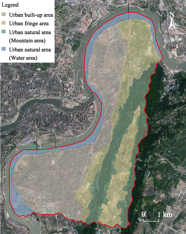
1 Introduction

China's mountainous area accounts for 69% of the country's total land area. Chongqing is a typical mountainous city, it accounts for 97% of the total area, according to the 2017 municipal geographical survey. Government data show that the urbanization level of Nanan District has reached over 90%, and it is currently in an important period of stock improvement with a large amount of urban construction. However, the formation of urban construction and landscape patterns, whether ancient natural settlements or modern man-made planning municipalities, is often inseparable from the habits and needs of human survival and activities, which depend largely on the landform and altitude within the region (Chen et al., 2005; Salvati and Zitti, 2011; Estoque and Murayama, 2017). Hence, the mountain area is a critical limiting and shaping condition for urban development and formation. In the current state of Nanan District urban development and the natural resources development and utilization of Nan Mountain, there is a need for certain data and theory research, the study of the area of the city landscape gradient characteristics, and the exploration of all kinds of factors and coupling of the construction of the city. This will lead to solutions for the problem of promoting the harmonious development of the city and the mountain environment, drive further development and perfect the functions.
With the construction and development of mountain cities, people pay more attention to the mountain environment. Since the establishment of the concept and basic theoretical framework of “Mountain Urbanology” (Huang, 2005), many detailed studies have been conducted on mountain cities to further understand and interpret the theory. At the macro level, studies on the basic functional characteristics of mountain land space and relevant construction optimization strategies (Deng et al., 2017), as well as the green space system and related evolution of mountain cities, have been constantly improved (Liu et al., 2016; Liu, 2017). A large number of individual aspects such as aesthetics, ecology, architecture and engineering technology in mountain cities have also been investigated and studied in detail (Chen, 2012; Liu, 2012; Xin, 2012; Yu, 2012). The analysis from all angles brings some suggestions for the construction of mountain cities, but the composite analysis from all angles and supported by a large amount of data still needs to be expanded at present.
For Chongqing, a typical mountain city, the development and evolution of the city is very complicated under the influence of the mountains (Chen et al., 2013). Nan Mountain is an important natural resource in Nanan District. Since the 1990s, a large number of ecological studies and analyses on the mountains and related urban built-up area in Nanan District have been conducted (Li et al., 2011); detailed statistical surveys and predictive assessments on flora, fauna, geological, and mineral resources have also been performed (Yu and Li, 1992; He, 2008). But most of them are singular analyses with strong pertinence, and the comprehensive analysis is limited. This paper reports a comprehensive study on landscape gradient characteristics and various aspects of urban construction in the study area, analyzes the coupling relations between them, then comes up with corresponding optimization measures for future urban development. The measures are likely to achieve higher economic and social values as well as ensure the stability of the ecological environment with the formation of a better landscape, leading to a two-way development and the harmonious coexistence of human society and the natural environment.

2 Research objects and methods

The area studied in this paper is in Nanan District of Chongqing, which is located in the subtropical monsoon climate zone. Nanan District is associated with high-degree seasonality: higher temperature and precipitation in summer in contrast to less precipitation in winter. The research area covers the north to the northernmost point of Nanan District, the middle section of Cuntan Yangtze River Bridge; south to the southern end of Nanbin Road and Babin Road junction, with orchid Road as the boundary of the horizontal extension; east to the east ridge line of Nan Mountain; and from the west to the middle line of the Yangtze River at the boundaries of Nanan District, Yuzhong District and Jiulongpo District; the longest span is about 13.5 km from north to south and about 8 km from east to west (Fig. 1). The area of study can be considered as a typical mountain city: Nan Mountain area has complicated topography and geology, diverse ecological environment and structure, great biodiversity, and many unique biological populations and communities; this area is also close to the Yangtze River with greater water-land interactions. Due to its large population, dense architecture, and rich social and cultural activities, various construction efforts have been carried out. Meanwhile, the rapidly changing landscape and ecology in the urban built-up, as well as the unstable urban fringe area ecology, make the natural areas susceptible to the effects of urban development.
Taking this region as an example, this study uses Landsat8 remote sensing image as the basis, and combines field survey data as the basic site data. By referring to the government data and the studies of many scholars in recent years, and using GIS, ENVI and other software, the appropriate charts, such as the elevation and slope direction map, land classification map, Voronoi map, etc., are drawn to conduct the site data analysis. From the perspective of landscape gradient and urban construction, this paper first analyzes the gradient from the aspects of land type, plant community and the changes of cultural and social activities. Then the economic development levels, population migration and spatial expansion trends of different urban construction areas are analyzed, and the coupling relations between them are analyzed. Finally, according to the coupling relationship analysis and the preliminary data analysis, the urban development problems and related optimization measures are proposed (Fig. 2).
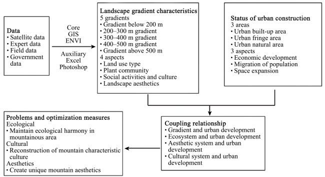
Fig. 2 Research framework

3 Research contents

3.1 Landscape gradient characteristics

To the east of the study area is a flat area with minimal change in relative elevation, while to the west is the Nan Mountain range. In the region, the lowest point is 88 m above sea level, the highest point is 681.5 m above sea level, so the range of altitude is 593.5 m. Every 100-m interval is taken as a gradient step, but the proportions of regions below 100 m and above 600 m in the overall research area are very low, so they are classified into the adjacent gradients for joint analysis. Therefore, the area is divided into five gradients: 0-200 m elevation zone is the first gradient, 200-300 m elevation zone is the second gradient, 300-400 m elevation zone is the third gradient, 400-500 m elevation zone is the fourth gradient, and 500-700 m elevation zone is the fifth gradient. DEM data for the study area are analyzed through GIS (Fig. 3).
Fig. 3 Geomorphologic analysis of the study area (January 2019) (a) Elevation analysis, (b) slope direction analysis, (c) slope analysis.
3.1.1 Changes in land use types
Based on Landsat 8 satellite data, combined with Google Earth images and field surveys, the interpretation and analysis of land use types are carried out after ENVI correction (Fig. 4). The classification is based on China's 2017 Land Use Status Classification, and some adjustments have been made. All the land, except for industrial land, traffic land, l eisure land, park and green land, shall be collectively referred to as construction land, and the artificial greening of parks, green land and other classified lands with large area shall be collectively referred to as artificial green land.
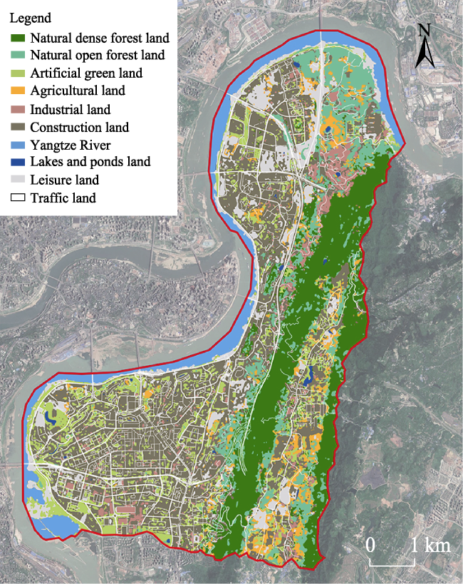
Fig. 4 Land use type analysis (January 2019)
It can be seen from Fig. 5 that the natural dense forest area basically does not exist in the area below 200 m. For the gradient from 200 to 300 m, its proportion gradually rises with the elevation, and basically remains at about 45% at 300 to 500 m and up to 79% in areas above 500 m, which is mainly related to the relationship between the distributions of urban built-up area and natural mountains. Natural open forest land has a slight upward trend from the gradient of 200-300 m. Combined with the dense forest area, the total proportion of natural forest land for the gradient of 300-500 m is about 60%, while the forest land above 500 m is basically covered by natural forest land. Artificial green land is mainly concentrated in the urban built-up area under 300 m. In terms of construction land, the 200-300 m gradient shows an obvious peak, which also corresponds to the two city centers, namely Danzishi and Nanping. Industrial and agricultural land is mainly concentrated in the 300-500 m gradient of the edge region of urban built-up area. Leisure land is mainly concentrated in the urban built-up area below 300 m. Due to the particular characteristics of the water area, the internal lakes and ponds are very limited, and basically concentrated in the Yangtze River water at less than 200 m.
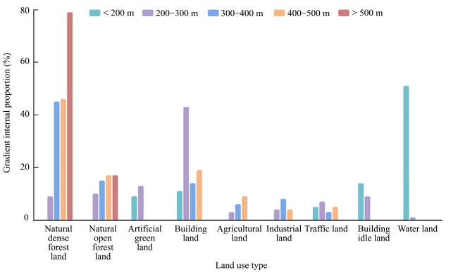
Fig. 5 Land use changes of each gradient (January 2019)
3.1.2 Changes in plant community
According to the current understanding of mountainous landscape ecology at present, in general, as the elevation changes in a mountains area, climate, soil, water, vegetation, animals and the natural geographical complex show clear vertical differentiation, forming a variety of interconnected bottom-up gradients, especially with vegetation as the main indicator of a certain structure of natural vertical zones, which is unique to the mountain vertical ecological landscape structure (Peng et al., 2016; Wang et al., 2017). This section analyzes the characteristics and changes of each gradient zone in the study area with the plant community as the main feature of the analysis.
Table 1 shows that the ecological natural state in the study area changes significantly at about 300 meters. The
Table 1 Plant analysis of each gradient (January 2019)
Gradient (m) Natural state Plant community distribution area Species diversity Common plants Plant community type Ornamental value
< 200 Medium Water front Medium Broussonetia papyrifera (Linnaeus) L'Heritier ex Ventenat, Ficus virens Aiton, Miscanthus sinensis Anderss., Arundo donax L., Duchesnea indica (Andr.) Focke, Humulus scandens (Lour.) Merr. Mainly composed of
grass and shrub, and more diverse wild native plants
Low
Roads and attached green space Low Ginkgo biloba L., Cinnamomum camphora (L.) Presl, Ficus virens Aiton, Osmanthus fragrans (Thunb.) Loureiro, Ligustrum × vicaryi Hort., Loropetalum chinense var. rubrum Yieh, Argyranthemum frutescens (L.) Sch.-Bip Mainly arbor, with a small amount of grass and shrub plants Medium
Parks and squares Medium Bauhinia purpurea L., Elaeocarpus decipiens Hemsl., Pterocarya stenoptera C. DC., Ficus virens Aiton, Cinnamomum camphora (L.) Presl, Yulania denudata (Desrousseaux) D. L. Fu, Prunus cerasifera f. atropurpurea (Jacq.) Rehd., Acer palmatum ‘Atropurpureum'(Van Houtte) Schwerim, Ligustrum × vicaryi Hort., Loropetalum chinense var. rubrum Yieh, Lantana camara L., Alpinia zerumbet (Pers.) Burtt. et Smith, Iris tectorum Maxim. The forest belt is
luxuriant, and the
artificial plant
community is rich in grass and shrub
High
200-300 Low Roads and attached green space Low Old building area: Ficus virens Aiton, Broussonetia papyrifera (Linnaeus) L'Heritier ex Ventenat, Cinnamomum camphora (L.) Presl, Osmanthus fragrans (Thunb.) Loureiro, Mallotus barbatus (Wall.) Muell. Arg. Simple artificial
community dominated by arbors
Low
New building area: Cinnamomum camphora (L.) Presl, Ginkgo biloba L., Koelreuteria bipinnata Franch., Platanus acerifolia (Aiton) Willdenow, Trachycarpus fortunei (Hook.) H. Wendl., Cerasus serrulata var. lannesiana (Carri.) Makino, Ligustrum ´ vicaryi Hort., Loropetalum chinense var. rubrum Yieh Road forest belt with high seasonal, color and ornamental effects Medium
Parks and squares Medium Ficus virens Aiton, Cinnamomum camphora (L.) Presl, Phoebe zhennan S. Lee et F. N. Wei, Metasequoia glyptostroboides Hu et W. C. Cheng The forest belt is
luxuriant, and the
artificial plant
community is rich in grass and shrub
High
Dwelling district Medium Ficus virens Aiton, Cinnamomum camphora (L.) Presl, Celtis sinensis Pers., Pinaceae Spreng. ex F. Rudolphi, Cupressaceae Gray, Viburnum odoratissimum Ker.-Gawl. The most abundant artificial area of arbor, shrub and grass Medium
300-400 High Agricultural district Low Fruits, vegetables, food crops Crops related to season and market supply and demand Low
Factory district Low Ficus virens Aiton, Broussonetia papyrifera (Linnaeus) L'Heritier ex Ventenat Dominated by arbors in the original mountain forest belt, lacking in shrub and grass layer Low
Mountain district High Pinus massoniana Lamb. (constructive species), Cinnamomum camphora (L.) Presl, Cornus controversa Hemsley, Broussonetia papyrifera (Linnaeus) L'Heritier ex Ventenat, Lindera glauca (Sieb. et Zucc.) Bl., Mallotus barbatus (Wall.) Muell. Arg. Dominated by natural forest belt, mixed with a small amount of
artificial forest, and has rich local plants
High
400-500 High Mixed area Medium Diverse agricultural plants, simple roads and community plants Multi type and small area interlaced artificial plant communities Low
Mountain district High Pinus massoniana Lamb.(constructive species), Cinnamomum camphora (L.) Presl, Broussonetia papyrifera (Linnaeus) L'Heritier ex Ventenat, Lindera glauca (Sieb. et Zucc.) Bl., Mallotus barbatus (Wall.) Muell. Arg. Basically natural forest belt with less artificial interference High
>500 High Mountain district High Pinus massoniana Lamb.(constructive species), Cinnamomum camphora (L.) Presl, Broussonetia papyrifera (Linnaeus) L'Heritier ex Ventenat, Lindera glauca (Sieb. et Zucc.) Bl., Mallotus barbatus (Wall.) Muell. Arg. Dominated by natural forest belt, with complex levels of native plants, without artificial
interference
High
gradients below 300 meters, except for riverside areas and a few remaining natural patches, are composed of plants with strong artificiality. In this area, the road forest belt in the newly built area and the reconstructed area usually have greater levels of trees, shrubs and grasses, while the old road forest belt in the old built area has lower levels of shrubs and grasses. Diverse plant species are observed in areas like parks and communities with high ornamental value, but they vary with time and have high instability. In the gradients above 300 meters, the edge of the urban built-up area has some fragmented agricultural vegetation, as well as the disconnected natural patches caused by industrial production and urban construction, which are relatively poor in ecological and ornamental value. Most other areas are located in the natural mountains. The vegetation is dominated by natural forest belts with a small amount of artificial interference. There are some artificially improved forest belts with rich plant species, a highly natural state and less development. At present, it is gradually evolving into a coniferous and broad-leaved mixed forest, with a certain improvement in the ornamental and ecological stability (Yu and Li, 1992).
3.1.3 Social activities and cultural changes
The construction and development of a city is a comprehensive reflection of the human activities in a region, so a city is not just a simple material complex. Different social activities with different characteristics in different regions produce different cultures, thus forming the unique cultural temperament of the region (Ye, 2006). The study area has the typical landscape of a mountain city, with the ancient, recent and modern cultural attractions distribution as shown in Fig. 6, which is the Voronoi diagram of the research area generated by ArcGIS and represents a plane partition method that is closely related to the distance. The coefficient of variation Cv value is the ratio of the standard deviation (SD) and the average (AVG) of the Voronoi polygon area. The Cv value can be used to measure the relative changes of elements in space. Duyckaerts and Godefroy (2000) suggested three key values: when Cv is less than 33%, the point set is uniformly distributed; when 33% ≤ Cv ≤ 64%, the point set is randomly distributed; when Cv is > 64%, the point set has a clustered distribution. Its calculation formula is as follows:
Cv = (SD/AVG) × 100%
The calculated Cv value of the research area is 106.25%, which indicates distribution in clusters. There are two peaks on the gradient, namely the riverside area at the junction of 200 m and 300 m, and the mountain area above 400 m. The riverside culture and landscape are mainly generated by shipping and trading-related activities. Although the area is small, it is the cultural and tourism landscape area at the core of the whole Nanan District. The culture and landscape above 400 m are mainly generated by religious, anti-war and climbing activities. However, the changes of hard culture, such as building streets and alleys, have obvious changes at about 300 m. The area under 300 m has been basically covered with modern buildings and roads. Some traditional Chongqing streets and alley buildings still remain in the mountain areas with higher gradients at the edge of the city, at about 300 m.
There are two change nodes in the changes of social activities. The social activities in the riverside area under 200 m and mountain area over 300 m are mostly sightseeing and entertainment due to the natural landscape, while the gradient of 200-300 m consists of a large number of residential and commercial areas, and the social activities are mostly live entertainment and activities influenced by businesses.
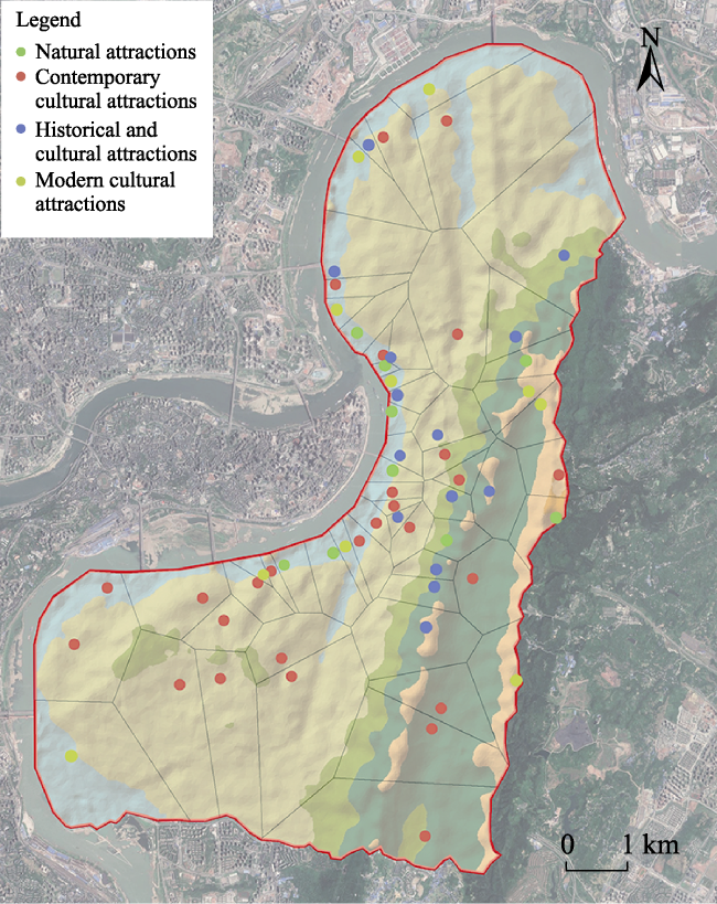
Fig. 6 Voronoi diagram of natural and cultural attractions (January 2019)
3.1.4 Changes of landscape aesthetics
This section analyzes the landscape aesthetics of mountain cities, and refers to the analysis and evaluation system and scale of many landscape aesthetics and landscape resources (Guo et al., 2000; Zhai et al., 2003; Yuan, 2004; Wang et al., 2006). In view of the particular features of mountain cities, an aesthetic evaluation table is developed (Table 2). The landscape resources and aesthetic performance in the study area were analyzed quantitatively by integrating the scores assigned by three professors who had a deep understanding of the area and 150 local people (Table 3).
Table 2 Aesthetic evaluation standard
Project Quantitative score Basis of grading
Mountainous region 0-2 Non-mountain landscape or common mountain, gentle slope, general shape
2-4 Beautiful mountain, high mountain, obvious characteristics
4-5 Characteristic mountain, with distinct characteristics, or cliffs, or tall and majestic, or with caves
Water body 0-2 No water or general water, small area, no special features, general sound, shadow, color, quality
2-4 More beautiful dynamic water body, personality is obvious, there is a sense of light or sound
4-5 Magnificent dynamic water features, prominent features, or with other factors to form a wonderful and elegant scenery
Flora and fauna 0-2 The vegetation structure is simple, the coverage rate is less than 50%, rare wild animals or none
2-4 The vegetation structure is complex, with a coverage rate of 50%-80%, many kinds of wild animals and some protected species
4-5 The vegetation structure is very rich, covering more than 80%, famous ancient trees, a wide variety of wild animals, key protected species
Ambience 0-2 There is no good ecological environment, some pollution, single color, lack of seasonal phase
2-4 Better ecological environment, comfortable and pleasant, less pollution, with more obvious color contrast and four season landscape
4-5 High quality ecological environment, rich color, obvious seasonal phases, quiet and comfortable, fresh air, up to the national level
Specificity 0-2 No attractions or general attractions, no specificity
2-4 Has a certain specificity and popularity
4-5 Has landforms, weather or other wonders, high visibility and popularity
Artificial landscape 0-2 Simple and common building streets, lack of characteristic resources and quality scenic spots
2-4 With a certain science, art, religion and other details, with certain local characteristics and reputation
4-5 With a long history, it has typical local characteristics and inheritance, and has high values of science, art and religion. It is the key object of regional protection
Folk custom and culture 0-2 Rigid and boring, high homogeneity, lack of local customs and cultural festivals
2-4 Has certain characteristics, but the inheritance is limited, the influence is low or only belongs to the characteristic culture affected area
4-5 Has a long heritage (soft and hard culture) and is located in the core area or origin area of the culture and
customs, with high popularity
As can be seen from Table 3, there are gradients below 200 m, at 400-500 m and above 500 m which have high scores. The core landscape resource below 200 m is water body. Compared with other gradients, water body resources have higher specificity, and the corresponding artificial landscapes, folk customs and cultural aesthetics are derived from it. The core landscape resources of 400-500 m are the mountain environment and some special cultural activity sites, which also have corresponding aesthetic value. The aesthetic value above 500 m is mainly generated by the mountainous environment. Although the 200-300 m gradient has a large area of artificial landscape, it is mostly mediocre, relatively lacking in characteristic landscape or specificity. The 300-400 m gradient, due to its rapid change, has high instability in all aspects, resulting in a slightly lower score.
Table 3 Aesthetic evaluation results for each gradient (January 2019)
Gradient (m) Mountainous region Water body Flora and fauna Ambience Specificity Artificial landscape Folk customs and culture Total points
<200 1.3 4.6 1.7 2.2 3.5 4.4 4.2 21.9
200-300 1.1 0.5 1.4 2.4 1.6 2.5 0.9 10.4
300-400 2.6 0.6 3.3 3.2 1.3 0.8 0.4 12.2
400-500 3.8 0.7 4.1 3.8 3.2 3.8 4.3 23.7
>500 4.1 0.7 4.8 4.2 3.1 1.4 0.8 19.1

3.2 Urban construction

Urbanization is a process of changing from a traditional agricultural society to a modern urban society dominated by the secondary and tertiary industries. It brings about the transfer of population and economy in the process and promotes the all-round development of the economy and society. In this process, the region also gradually forms several sections that are affected by the core area, which generally include the urban section, urban-rural fringe section, rural section, natural section, and others (Li, 2014).
The urbanization degree of Nanan District is extremely high, fluctuating around 95% statistically in 2014 and 2016. However, because the study area is located in a mountainous environment, it is difficult to draw a clear urban-rural boundary like in the conventional plain cities. As shown in Fig. 7, the study area is roughly divided into three sections by referring to the data related to the regional population and economy, urban landscape and satellite data analysis. The natural section is located west of the middle line of Nanbin Road and within the line of the mountain forest margin. The road with different features on both sides is used as the division between the urban fringe area and the urban built-up area. The narrow area in the middle of the mountain range is divided into the urban fringe according to its economic influence and environmental construction level.
Fig. 7 Urban construction in the study area (January 2019)
3.2.1 Urban built-up area
As for the economic development, the urban built-up area is in a state of double core, and the radiation influence of Nanping in the two cores is much higher than Danzishi. As the core region of economic development in the research region, the economic development level of Nanping is the highest and the fastest, and it is also the main economic output region. On the issue of population migration, the annual fluctuation of the fixed population is relatively small, and the active population migration caused by various social activities, such as daily work, business, and tourism, is relatively high. The stable fixed population and a certain amount of active population migration have reflected the fact that the urbanization development in the region has reached a relatively stable state. The space expansion is slow, and the expansion to the west and north has basically reached its limit as it is near the Yangtze River. To the east, the urban fringe area is gradually merging, but due to the mountains, the remaining available space is limited; construction on the south side has basically reached saturation, and gradually expanded to border on Banan District outside the study area. Therefore, at present, the urban built-up area is mainly that which has been demolished, rebuilt and renovated in the existing urban construction area, and it has gradually merged with the urban fringe area. Only in the north of Danzishi is there a certain area of undeveloped land, but it has been basically owned and will be completed in the coming years.
Fig. 8 Landscape relationships (January 2019)
3.2.2 Urban fringe area
The situation of the urban fringe area in the study area is relatively complicated, because the urban area connects the core urban area of Chongqing in the west and the north across the Yangtze River, and connects the Banan urban area in the south. Therefore, it is not a common ring urban fringe, but has a zonal distribution in the east of the urban section, and this is also a common urban fringe pattern in many riverside mountain cities. The difference between a mountain city and a plain city lies in the fact that it is a special region gradually transitioning from urban area to mountain area. It has certain altitude and slope, complicated natural conditions such as geology and hydrology, and its development and expansion are restricted by various conditions, which makes it extremely difficult.
The level of economic development in the urban fringe area is relatively poor compared with the built-up area, and the level of economic development within the area is relatively uniform without a dominant core, which is mainly affected by the radiation of the urban core area in the built-up area. The production activities in the region are mainly industry and agriculture, which are linearly distributed according to the gradient shape of the location. The tertiary industry content is relatively small and basically concentrated in a small number of residential areas and near schools in a relatively flat area in the central part of the mountain range. The amount of population migration is low, and basically represents the active migration caused by industrial activities. The state of spatial expansion is divided into two parts. The area on the left of the mountain range is gradually shrinking, and it is tending to be gradually merged through the development of the urban built-up area. A small amount of it is expanding to natural area, but the space for expansion is very limited. Although the central region of the mountain range is developing towards a high level of urbanization, it would be difficult for it to develop into a new regional core due to the constraints of space, population, traffic and other conditions.
3.2.3 Urban natural area
Due to the limited degree of development within the region, the level of economic development cannot be compared with the other two gradients. The main economic income comes from forestry development, various historical sites and natural landscape tour related industries. In terms of population migration, there is barely any settled population or a large number of immigrants who have settled in. As there are many cultural and scenic spots in the region, it is mainly the active population migration led by cultural and tourism activities. The spatial expansion is basically stable, and the land properties of the lot boundary area change frequently, but there is no large-scale expansion or reduction.

4 Analysis and discussion

4.1 Coupling relationship analysis

Coupling, as a physical definition, originally referred to the phenomenon of interdependence and mutual influence between two or more systems under various actions. This theory is of great value in the study of urban development. Through fitting analysis of the data in Fig. 2, Fig. 3, Fig. 5 and Fig. 6, the coupling relationships between each component in the landscape gradient and urban construction can be obtained.
The urban built-up area in the study area is coupled with the low altitude gradient, which mainly fits the elevation zone below 200 m and most of the 200-300 m elevation zone. The main characteristics of the region are low altitude, flat terrain, and small slope, which are very conducive to various types of development and construction, and it has a long history, with certain living conditions, so long-term development makes all aspects of the development and construction conditions better. Urbanization has a great impact on the environmental systems. Due to the high degree of artificialization, the ecological environment system within the gradient of the section is under severe artificial control, and the ecology is weak, while the few remaining natural patches are gradually absorbed. The cultural environment system is highly modernized and commercialized under that influence, and a large number of historical cultures and characteristic cultures are gradually disappearing. The specific landscape resources are mainly the water resources in the riverside area, which have specific aesthetic value, while the natural, artificial and humanistic aesthetics in the aesthetic environment system of the main built-up areas are not very prominent.
The urban fringe area of the study area mainly occupies the interface between the 200-300 m elevation zone and the 300-400 m elevation zone, and the flatter area in the 400-500 m elevation zone. Compared with urban built-up area, these areas usually have a certain altitude and a certain slope but are smaller than natural areas. In these areas, environmental systems are affected by urbanization to a certain extent, land use types are diverse, interweaving is very complex, and the future development trend is uncertain to a certain extent. The ecological environment system is often affected by industry and agriculture, and the situation is not very optimistic. The main component of the cultural environment system is modern urban culture, and there are few historical and cultural relics which are not obviously affected by urban development. Due to the diverse nature of land use and rapid environmental changes, the aesthetic environment system is relatively weak, and there is a lack of quality resources.
There is a certain coupling between the urban natural section and the higher altitude gradient in the study area, which is mainly composed of the Nan Mountain range. Compared with the elevation zone, it mainly fits the majority of the 300-400 m elevation zone, the 400-500 m elevation zone (except for the flat urban fringe in the central part of the mountain range) and the elevations above 500 m. Its characteristics are mainly location in a mountainous area with high altitude, steep slope and complex terrain, which makes it difficult to carry out large-scale construction, development and utilization, and it is subject to national laws and regulations related to natural ecology and key protection. The environmental systems in this area are generally less affected by urbanization and the ecological environment system is in good condition. The cultural environment is often associated with the preservation of history and has not been eroded by excessive modernization like the urban built-up area. The mountain resources in the aesthetic environment system are very prominent, and the corresponding extension of human and artificial aesthetics have a high value of appreciation and protection.
Table 4 Air quality statistics of the research area (2016-2018)
Year 2016 2017 2018
Month AQI Range Quality grade AQI Range Quality grade AQI Range Quality grade
Jan. 96 43-202 Fine 117 42-220 Light pollution 79 35-190 Fine
Feb. 96 32-205 Fine 87 45-164 Fine 78 32-156 Fine
Mar. 82 30-148 Fine 69 43-113 Fine 59 37-93 Fine
Apr. 71 40-122 Fine 65 35-97 Fine 62 29-108 Fine
May 77 35-141 Fine 77 36-145 Fine 67 29-130 Fine
Jun. 75 29-158 Fine 76 41-131 Fine 69 36-172 Fine
Jul. 69 35-140 Fine 93 38-193 Fine 70 32-126 Fine
Aug. 72 35-116 Fine 85 30-163 Fine 93 40-138 Fine
Sep. 95 52-186 Fine 56 28-100 Fine 54 32-111 Fine
Oct. 61 39-94 Fine 52 25-111 Fine 61 38-108 Fine
Nov. 78 35-123 Fine 80 47-132 Fine 67 32-100 Fine
Dec. 100 52-152 Light pollution 109 49-202 Light pollution 73 33-178 Fine
Average 81 38-149 Fine 81 38-148 Fine 69 34-134 Fine

4.2 Development problems and optimization measures for each gradient

4.2.1 Maintain ecological harmony in the mountainous area
The study area has mountains and rivers, but as shown in Fig. 8, large areas of natural patches and artificial green space are very limited in number and area, so they cannot play a good tandem role. Excessive land development and utilization have caused the Nan Mountain range and the Yangtze River system to be divided into large areas of urban hard land at 200-300 m, which has hindered the normal flow of seasonal winds, water and land winds, and valley
winds, and produced the urban heat island effect. The air quality in the high-density urban environment is not optimistic. The urban air quality index fluctuates greatly, and the average value is close to the slight pollution threshold. There are some problems with pollution emissions (Table 4). According to the relevant statistics of some scholars, the pollution caused by fossil fuel combustion is more prominent under the influence of the special mountain environment, causing acidic rainfall in the region, which has a significant impact on the growth of mountain plants (Yu et al., 1988; Jiang et al., 2002).
We propose three optimization measures. First of all, control the pollution discharge for the riverside area below 200 m. Secondly, for the 200-300 m elevations of major urban built-up area, the establishment of appropriate ecological green corridors and green patches can not only connect the relationships between mountains and water arteries to form good ecological benefits, but also greatly improve the urban environment and absorb pollutants from the air. Thirdly, for the urban fringe area and natural area over 300 m, we should strengthen nature protection, strictly control industrial development and pollution emission, and accelerate industrial upgrading. We should also give more scientific support to agricultural development, improve the agricultural environment and complete the modernization transformation.
4.2.2 Reconstruction of the mountain characteristic culture
The relationship between mountain and water provides residents with a special natural environment, and then gives rise to the corresponding artificial and human environment. It has a special cultural system which is distinct from that of plain cities. However, in the current construction of many mountain cities, the emphasis on culture is far from sufficient, and the city construction is blindly regarded as an economic activity driven by the excessive pursuit of economic benefits. In addition, due to the complexity of China's modern social development, the developmental resources, developmental speed and level of cities in the eastern plain region are much higher than those in the central and western regions. Therefore, the development of many cities in the central and western regions of the mountainous and hilly area mostly draw lessons from the development experiences of the plain cities, while playing down the distinctive characteristics of the mountainous area (Liu, 2012; Yu, 2012). In addition, in order to create an international city, many planning methods and architectural forms of other countries have been imitated, and some buildings such as the Twin towers of Nanbin Road have been built, which seriously affect the regional features.
Therefore, we should refer to the characteristic cultural gathering areas in Fig. 5 and the corresponding specific mountain aesthetic resources. First of all, we should strictly protect the cultural buildings and landscapes of various types which are clustered in the boundary area between 200-300 m and the gradient belt below 200 m. Secondly, for the 200-300 m of urban built-up area of buildings, streets, parks, squares and other areas need to embody the characteristic planning and design to show the characteristics of the mountain features. Thirdly, on the basis of protecting the natural environment, reasonable development and construction of cultural heritage should be carried out in mountainous areas above 300 m above sea level to strengthen their relevant cultural values (Li et al., 2009; Du et al., 2016).
4.2.3 Create unique mountain aesthetics
The aesthetic resources with regional characteristics should be focused on and strengthened, especially those in the urban built-up area with poor specificity mentioned above. In this area, some landscapes that are not quite reasonable are constantly occupying the position of original characteristic landscapes. For example, in the riverside, some traditional Chongqing-style buildings combined with the mountain environment are very rare, with high-rise, super-high-rise and related types accounting for 59.5% (Table 5). Such a high collocation greatly blocks the sight line, making the naturally rich landscape level in the mountainous area become rigid, and the specific landscape content gradually loses its aesthetic characteristics.
Table 5 Statistics of riverside buildings in the study area (January 2019)
Building type Low-rise buildings Multi-storey building High-rise buildings Super tall building Combination of low-rise and multi-storey buildings Combination of low-rise and high-rise buildings Combination of multi-storey and high-rise buildings Combination of mountains and multi-storey buildings Mountain and high-rise building combination No construction
Proportion (%) 3.3 15.3 17.0 15.7 4.0 4.8 18.0 13.3 4.0 4.6
To create a unique mountain aesthetic, it is necessary to build a reasonable urban skyline. We can refer to Huang Guangyu's eight levels of mountain three-dimensional contour lines, namely river surface line-Shoreline-Riverside Road Route-Riverside Building contour line-backward building contour line-near scene contour line of mountains-far scene contour line of mountains-sky line (Huang, 1999). First of all, the waterfront buildings at the junction of 200 m and 300 m elevations should be appropriately adjusted and reconstructed to strictly limit the building height. Secondly, for the main urban built-up area of 200-300 m, the buildings should be reasonably clustered to form an appropriate visual center, and the corresponding relationship with the mountain contour should be formed by means of strengthening, conforming and breaking. Then, for the area above 300 m, the hard construction should be strictly controlled and approved. First of all, the mountain outline should be reasonably protected. Changes can be made on-demand through plant cultivation and the layout of pavilions and towers. Through these efforts, urban buildings and mountains will match and complement each other to better present a rich and appropriate sense of space and hierarchy (Qiu, 2009; Li, 2012).

5 Conclusions

This paper takes Nanan District of Chongqing from the Yangtze River to the east ridge line of Nan Mountain as an study area. It then analyzes and interprets the relevant governmental data and the views of a large number of scholars, mainly through various kinds of satellite image interpretation combined with a large number of field explorations, and makes a detailed analysis of the five elevation gradients in the study area from four aspects: 1) spatial structure and landscape composition, 2) natural ecology, 3) social activities and culture, 4) landscape aesthetics, and the coupling relationship between elevation gradient and different urban areas (urban built-up area, urban fringe area, urban natural area) are also analyzed. Through the analysis of the coupling law and relevant data, this paper puts forward three main strategies: 1) maintain ecological harmony in mountainous area, 2) reconstruct the mountain characteristic culture, 3) create unique mountain aesthetics. We hope this study will provide help for the future development of the research area and similar mountain cities. However, mountain cities in different regions also have different base conditions, opportunities and challenges. It is hoped that more complex multi-dimensional analyses will be conducted in the future to generate more high value urban development suggestions and further show the natural and cultural diversity and uniqueness of the different types of mountain cities.
1
Chen D, Zhou Q G, He C H , et al. 2013. Study on the topographical characteristics of land use change in Chongqing mountainous metropolitan area from 1985 to 2010. Research of Soil and Water Conservation, 20(5):210-215, 220. (in Chinese)

2
Chen G, Dai Z Z, Huang H J . 2005. Hierarchical analysis of mountain space landscape. Journal of Chongqing Jianzhu University, 49(2):26-29. (in Chinese)

3
Chen L . 2012. Research on mountainous city design based on technology view. Diss., Chongqing, China: Chongqing University. (in Chinese)

4
Deng W, Zhang J F, Shi Z Q , et al. 2017. Conceptual model and theoretical framework of analysis and optimization of mountain land space. Mountain Research, 35(2):121-128. (in Chinese)

5
Du C L, Liu T T, Mao H S . 2016. Research on the complexity and coping strategies of mountain town landscapes—Taking Bayu Town as an example. Landscape Architecture, 12(7):80-88. (in Chinese)

6
Duyckaerts C, Godefroy G . 2000. Voronoi tessellation to study the numerical density and the spatial distribution of neurones. Journal of Chemical Neuroanatomy, 20(1):83-92.

DOI

7
Estoque R C, Murayama Y . 2017. Monitoring surface urban heat island formation in a tropical mountain city using Landsat data (1987-2015). ISPRS Journal of Photogrammetry and Remote Sensing, 133(11):18-29.

DOI

8
Guo L X, Wu B H, Liu F , et al. 2000. Study on the tourist resources classification system and types evaluation in China. Acta Geographica Sinica, 55(3):294-301. (in Chinese)

9
He D X . 2008. Analysis of the fragility of the ecological environment of Chongqing’s typical karst mountains and discussion on ecological reconstruction. Diss., Chongqing, China: Southwest University. (in Chinese)

10
Huang G Y . 1999. Shaping the urban space of Chongqing in the 21st century. Chongqing Architecture, 5(3):11-16. (in Chinese)

11
Huang G Y . 2005. Ecological thinking over spatial structure of hilly city. City Planning Review, 29(1):57-63. (in Chinese)

12
Jiang W H, Zhang S, Chen G C , et al. 2002. Effect of acid deposition on the soil and vegetation of forest ecosystem in Nan Mountain of Chongqing. Research of Environmental Sciences, 15(6):8-11. (in Chinese)

13
Li H K . 2014. Research on the coupling of urbanization and urban ecological environment based on urban gradient model. Diss., Dalian, China: Liaoning Normal University. (in Chinese)

14
Li X B, Chen M H . 2009. Analysis of mountain landscape construction methods. Shanxi Architecture, 35(8):20-21. (in Chinese)

15
Li Y . 2012. Study on landscape design adapting to mountainous city waterfront. Diss., Chongqing, China: Chongqing University. (in Chinese)

16
Li Y J, Wang H Y, Feng H . 2011. An analysis of the landscape component characteristics of the mountain landscape ecological complexes in Nan’an District of Chongqing. Journal of Southwest University (Natural Science Edition), 33(12):145-149. (in Chinese)

17
Liu J . 2017. Study on the problems and countermeasures of the urban green space system planning in mountain city. Chinese Landscape Architecture, 33(9):67-71. (in Chinese)

18
Liu X Y . 2012. Research on mountainous city design based on aesthetics. Diss., Chongqing, China: Chongqing University. (in Chinese)

19
Liu Y, Zhang X X, Chen J Y . 2016. Evolution of green space and its impact on urban expansion in mountainous cities: Taking Chongqing as an example. Journal of Human Settlements in West China, 31(6):69-73. (in Chinese)

20
Peng J, Ma J, Du Y Y , et al. 2016. Ecological suitability evaluation for mountainous area development based on conceptual model of landscape structure, function, and dynamics. Ecological Indicators, 61(2):500-511.

DOI

21
Qiu Q . 2009. Research on the shaping of the style and features of the vertical outline of mountain cities: A case study of Chongqing Yuzhong Peninsula. Modern Urban Research, 24(1):43-47. (in Chinese)

22
Salvati L, Zitti M . 2011. Monitoring vegetation and land use quality along the rural-urban gradient in a Mediterranean region. Applied Geography, 32(2):896-903.

DOI

23
Wang G X, Liu G H, Shen Z H , et al. 2017. Research progress in mountain landscape ecology. Acta Ecologica Sinica, 37(12):3967-3981. (in Chinese)

24
Wang J J, Li C Y, Tian M Z . 2006. Construction of ecological tourism resource classification and evaluation system. Geographical Research, 25(3):507-516. (in Chinese)

25
Xin J . 2012. Research on mountain city design based on ecological view. Diss., Chongqing, China: Chongqing University. (in Chinese)

26
Ye S S . 2006. Cultural development pattern and potential in Nanan District of Chongqing City. Diss., Chongqing, China: Chongqing University. (in Chinese)

27
Yuan S Q . 2004. Analysis on the characteristics, types and evaluation system of ecotourism resources. Journal of Ecology, 23(2):109-113. (in Chinese)

28
Yu S W, Yu Z W, Ma G J , et al. 1988. A preliminary study on the causes of decline of Mawei pine forest in Nan Mountain, Chongqing. Environmental Science, 13(3):77-81. (in Chinese)

29
Yu T M . 2012. Research on mountain city design based on cultural view. Diss., Chongqing, China: Chongqing University. (in Chinese)

30
Yu X P, Li X . 1992. Quantitative classification of Masson pine community in Nan Mountain, Chongqing. Journal of Chongqing Normal University (Natural Science Edition), 9(1):55-60, 81. (in Chinese)

31
Zhai M P, Zhang R, Yan H P . 2003. Review on the studies on scenic evaluation and its application in scenic forest construction both at home and abroad. World Forestry Research, 16(6):16-19. (in Chinese)

Outlines

/