
Journal of Resources and Ecology >
Spatio-temporal Differentiation of Trade-offs and Synergies of Ecosystem Services in Typical Mountain Areas of China
Received date: 2020-09-24
Accepted date: 2020-12-20
Online published: 2021-05-30
Supported by
The National Natural Science Foundation of China(41771115)
National Key Basic Research and Development Program(2015CB452706)
Guizhou Science and Technology Fund (Guizhou Technology Cooperation Basis)([2018]1116)
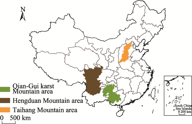
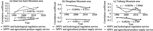
Mountain area accounts for a high proportion of the land area in China, and it is the focal area to solve the contradiction of imbalanced regional development, as well as an important source of ecosystem services. Therefore, this area has been facing long-term pressure and challenges in economic development and ecological protection. In this paper, we selected a rocky desertification mountain area, an active mountain area of new tectonic movement and a typical northern earth-rock mountain area, as Qian-Gui karst Mountain area, Hengduan Mountain area and Taihang Mountain area, as examples to represent three main types of mountain areas. Three representative types of ecosystem services, including NPP (Net Primary Productivity) as a support service, water conservation as a regulation service, and agricultural produce as a supply service, were incorporated into this study. Linear regression, correlation analysis and other methods were then used to investigate the spatial-temporal characteristics of the trade-offs and synergies in each of the three kinds of mountain areas during 1990-2015 in China. The analysis yielded three main conclusions for the three mountainous areas. (1) The agricultural produce supply service decreased relatively, while the support and regulation services of NPP and hydrological regulation increased significantly. (2) There was a synergistic relationship between NPP and the hydrological regulation services in the three mountainous areas. The synergistic relation in Qian-Gui karst Mountain area became enhanced, while those in Hengduan and Taihang Mountain areas became weakened, and the former was weakened to a greater extent. There was a trade-off between NPP, the hydrological regulation service and the agricultural produce supply service among the three mountainous areas. In particular, the trade-off between NPP and the agricultural produce supply service in Qian-Gui karst Mountain area became weaker, while those in Hengduan and Taihang Mountain areas were enhanced, and the latter was enhanced to a greater degree. (3) Significant spatial differentiation was evident in the trade-offs and synergies of ecosystem services among the three mountain areas.
FENG Yanyun , ZHAO Yuluan , YANG Zhimou , XUE Chaolang , LIU Yan . Spatio-temporal Differentiation of Trade-offs and Synergies of Ecosystem Services in Typical Mountain Areas of China[J]. Journal of Resources and Ecology, 2021 , 12(2) : 268 -279 . DOI: 10.5814/j.issn.1674-764x.2021.02.013
Fig. 1 Location map of study area |
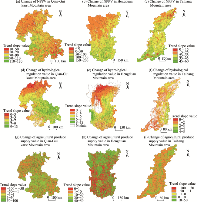
Fig. 2 Change trends of ecosystem service values in the typical mountain areas during 1990-2015 |
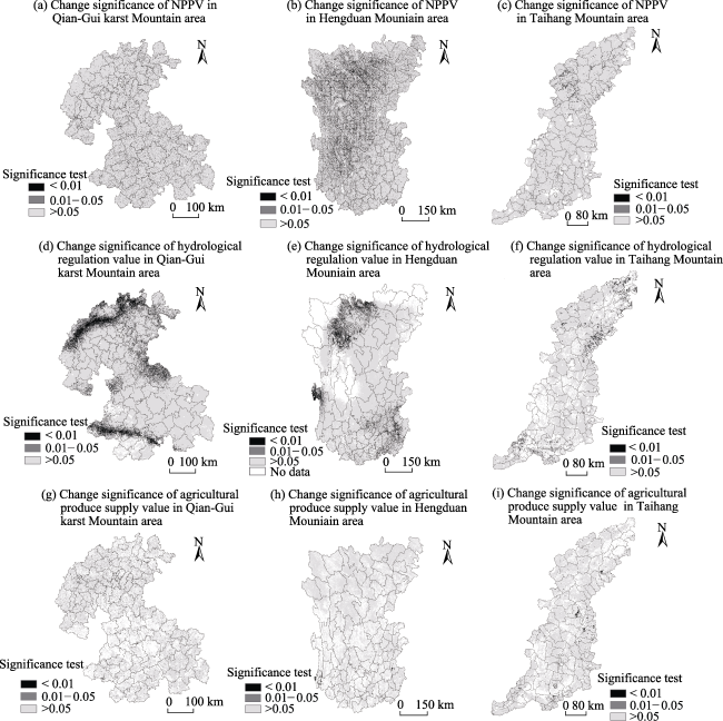
Fig. 3 Significant changes in ecosystem services of typical mountain areas during 1990‒2015 |
Table 1 Correlation coefficients for mean values of ecosystem services in the typical mountain areas during 1990‒2015 |
| Name of mountain area | Type of ecosystem service | Value of NPP | Value of hydrological regulation | Value of agricultural produce |
|---|---|---|---|---|
| Qian-Gui karst Mountain area | Value of NPP | 1 | 0.15125** | ‒0.28456** |
| Value of hydrological regulation | - | 1 | ‒0.04425** | |
| Value of agricultural produce supply | - | - | 1 | |
| Hengduan Mountain area | Value of NPP | 1 | 0.28832** | ‒0.34052** |
| Value of hydrological regulation | - | 1 | ‒0.13174** | |
| Value of agricultural produce supply | - | - | 1 | |
| Taihang Mountain area | Value of NPP | 1 | 0.19587** | ‒0.19029** |
| Value of hydrological regulation | - | 1 | ‒0.07670** | |
| Value of agricultural produce supply | - | - | 1 |
Note: ** significant correlation at P < 0.01 (two-tailed) |
Fig. 2 Change trends of ecosystem service values in the typical mountain areas during 1990-2015 |
Table 2 Statistical results of correlation coefficients among ecosystem services of the three typical mountain areas during 1990-2015 |
| Correlation coefficient | Name of mountain area | 1990 | 2000 | 2010 | 2015 | Min | Max | SD. |
|---|---|---|---|---|---|---|---|---|
| Between NPP and the hydrological regulation | Qian-Gui karst Mountain area | 0.01 | 0.28 | 0.16 | 0.25 | 0.01 | 0.28 | 0.11 |
| Hengduan Mountain area | 0.37 | 0.34 | 0.23 | 0.28 | 0.23 | 0.37 | 0.05 | |
| Taihang Mountain area | 0.24 | 0.05 | 0.14 | 0.11 | 0.05 | 0.24 | 0.07 | |
| Between NPP and the agricultural supply | Qian-Gui karst Mountain area | ‒0.26 | ‒0.26 | ‒0.22 | ‒0.18 | ‒0.26 | ‒0.18 | 0.03 |
| Hengduan Mountain area | ‒0.28 | ‒0.28 | ‒0.29 | ‒0.30 | ‒0.30 | ‒0.28 | 0.01 | |
| Taihang Mountain area | ‒0.13 | ‒0.13 | ‒0.21 | ‒0.18 | ‒0.21 | ‒0.13 | 0.03 |
Fig. 4 Dynamic variations in correlation coefficients of ecosystem services in the three typical mountain areas during 1990‒2015 |
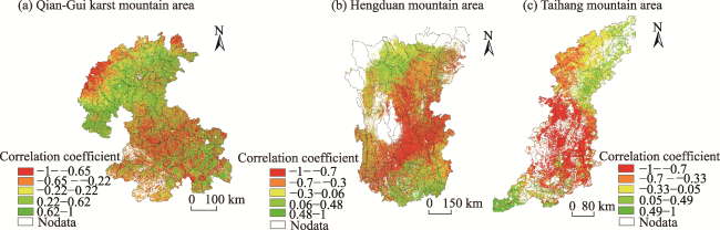
Fig. 5 Spatial differentiation of the synergistic relationship between NPP and the hydrological regulation services in typical mountain areas during 1990‒2015 |
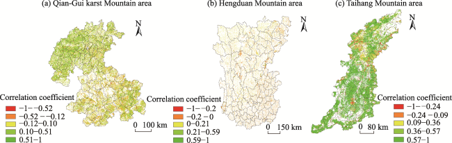
Fig. 6 The spatial differences of the trade-offs relationship between NPP and the agricultural product supply service in the typical mountainous areas during 1990-2015 |
| 1 |
|
| 2 |
|
| 3 |
|
| 4 |
|
| 5 |
|
| 6 |
|
| 7 |
|
| 8 |
|
| 9 |
|
| 10 |
|
| 11 |
|
| 12 |
|
| 13 |
|
| 14 |
|
| 15 |
MEA (
|
| 16 |
|
| 17 |
|
| 18 |
|
| 19 |
|
| 20 |
|
| 21 |
|
| 22 |
|
| 23 |
|
| 24 |
|
| 25 |
|
| 26 |
|
| 27 |
|
| 28 |
|
| 29 |
|
| 30 |
|
| 31 |
|
| 32 |
|
| 33 |
|
| 34 |
|
/
| 〈 |
|
〉 |
