Land Use Change and Land Multifunction Tradeoffs

Functional Transformation of Rural Homesteads: A Field Survey of Poyang County, Jiangxi Province, China

  • TU Xiaosong 1 ,
  • SUN Qiurong 2 ,
  • XU Guoliang 1 ,
  • WU Xiaofang 1
Expand
  • 1. School of Tourism and Urban management, Jiangxi University of Finance and Economics, Nanchang 330013, China
  • 2. Guangdong Institute of Land Resources and Environment, Guangzhou 510650, China

TU Xiaosong, E-mail:

Received date: 2020-08-20

  Accepted date: 2020-11-01

  Online published: 2021-05-30

Supported by

The National Natural Science Foundation of China(41561039)

Abstract

The rural homestead is a major part of the rural land system, which is an important carrier of various rural issues such as rural decline, rural hollowing and others. Great changes have occurred in China's rural areas, while the rural homestead has also undergone transformation. Based on summarizing the multi-functional classification of homesteads from previous research, this study divided and defined the population bearing function, assets, and residential function of homesteads from the perspective of functional improvement according to the results of a survey questionnaire. Using Poyang County as the case study, this paper analyzed the functional transformation of rural homesteads through the model of coordinated transformation degree. The results demonstrated the following trends. (1) From 2000 to 2017, the transformation degrees of rural homestead functions in Poyang County have obviously improved overall. (2) The high value areas of the transformation degrees were mainly distributed in the northern hilly region and around Poyang Lake, while most of the low value areas were distributed in the plain areas near the county town. (3) In the regions with better location conditions and resource endowments, the basic conditions and trend of non-agriculturalization of the population, capital and other factors are more significant. According to the differentiation of rural homestead transformations which occurred in different regions, the government could put forward targeted development suggestions for the future.

Cite this article

TU Xiaosong , SUN Qiurong , XU Guoliang , WU Xiaofang . Functional Transformation of Rural Homesteads: A Field Survey of Poyang County, Jiangxi Province, China[J]. Journal of Resources and Ecology, 2021 , 12(2) : 214 -224 . DOI: 10.5814/j.issn.1674-764x.2021.02.008

1 Introduction

The rural homestead is a form of land use in the rural land type. As a carrier of rural production and life, rural housing carries the developmental process of rural transformation. Meanwhile, homesteads in rural areas have been profoundly transformed in recent years.
Through a series of reforms, the process of urbanization in China has been accelerated, a large proportion of the rural population has poured into the cities, and the scale of the rural resident population has declined sharply in some areas of China (Zhang et al., 2003). While the agricultural population has swarmed into cities, that shift has not led to a relative reduction of the number of rural homesteads (Cao et al., 2019). The phenomena of “one family but more than one residence”, “hollow village” and the disordered extension of villages have become more serious (Xu et al., 2016). The Chinese government was forced to establish a standard that the per capita area of rural homestead should not exceed 25 m2. Also, the rural homestead withdrawal mechanism became gradually erected. During the shift from the agricultural society to the industrial society, great changes have taken place in the function and form of rural homesteads (Song et al., 2014).
It is an undisputed historical fact that farmers played an irreplaceable role in maintaining social stability and protecting national food security during each historical stage. Rural housing land is the land used by rural villagers for their housing buildings and other facilities related to their daily lives, including the land for main houses, attached houses, walls, roads, etc. (Feng and Yang, 2015). The rural house-site is a complex land use composite. The function of the rural homestead is derived from the usefulness of the houses for farmers, that is, what farmers do with their homesteads. As a type of land use, rural homestead has the characteristics and functions of land, in part. In China, due to the unique social system and the specific situation of each region, the rural housing which carries people’s food, clothing, housing, and transportation has a specific function. The functions of rural settlements fully reflected the characteristics and actual state of the period. The versatility of land starts from its role as the “carrier” of human activities, and its connotation is constantly enriched with the improvement of human “demand”.
In the earlier stage period, the function of rural areas was determined by agriculture, land quality and other natural conditions. The quality of rural land and the suitability of agricultural development were once considered to be the key factors in the distribution of rural homesteads. Nevertheless, the more specialized social division of labor, urbanization and other social and economic components continued to accelerate the changes in the structure and function of rural homesteads. Based on the rural status quo, scholars have analyzed and demonstrated the multi-functional nature of rural residential areas from multiple perspectives.
From the perspective of farmers’ needs, Zhao et al. (2019) divided the functions of homesteads into production functions, ecological function, guarantee function, and property function. Keeping pace with the further implementation of China’s homestead withdrawal mechanism, Kong et al. (2019) has classified the housing land functions from the perspective of homestead withdrawal. The main functions included housing security, economic property, production, and ethical functions. According to the characteristics of each stage of industrialization, Jiang et al. (2016) have classified the functions of rural homesteads, such as living function, production function, ecological service function and income function. In general, the basic function of rural homestead was a social security function. Homesteads not only guaranteed the vital interests of farmers, but also stabilized the social environment. Due to the change of social situations, other functions such as ecological services and asset functions were also gradually highlighted, and they have become the leading functions in some areas (Peerzado et al., 2018).
The behavioral subject of homesteads is human, as human demand directly determined the transformation and promotion of the function of homesteads. From the perspective of functional enhancement, rural homestead functions were divided into population capability function, asset function and residential function. Population capability function was directly reflected in the population that the homestead can contain. Urbanization and rural hollowing have increased the area of homestead owned by each person. The number of permanent residents and the employment structure of rural households have also changed. These phenomena have been considered in the design of the questionnaire used in this study (as described below). The function of asset is that the farmers use their homestead for renting or selling, in order to obtain asset income. As a piece of real estate, the construction cost and service life play a fundamental role in the value of the homestead itself (Wu et al., 2018). In order to improve the values of homesteads, more people have increased their input of the construction cost of buildings. In recent years, the government has encouraged the paid withdrawal and transfer of homesteads, which further highlighted the asset function. The residential function was mainly for the building structure of homesteads. Simple wooden or brick-wood structures simply meet the needs of living, new rural construction, and the improvement of people’s quality of life, as people need high quality living conditions (Su et al., 2019). The transformation of the residential function is not only reflected in the residential structure, but also in the interior decoration, sanitary conditions, and modernization degree of homesteads (Li et al., 2020).
Scholars in rural geography have begun to explore the regional differences in rural areas and to study the multifunctional transformation of homesteads (Lu et al., 2010; Liu et al., 2011; Chen et al., 2014; Zhang et al., 2015). The research on the functional transformation of rural homestead is mainly related to spatial patterns, driving mechanisms and functional transformations, and similar aspects. Based on GIS spatial technology, using spatial autocorrelation, landscape pattern indexing and other methods, scholars have analyzed the spatial pattern characteristics of rural settlements. Chen et al. (2014) used spatial autocorrelation and other spatial statistical methods to measure the spatial distribution concentration and expansion trend of rural residential areas, and to determine the driving forces. Based on an analysis of the spatial layout characteristics of rural residential areas, Liu et al. (2011) applied the expert consultation method to calculate the influencing factors in order to optimize and adjust the layout of different rural residential areas. Lu et al. (2010) analyzed the spatial structure relationship and evolution path of rural homesteads in different areas based on farming radius, and put forward guidance for the optimization of homestead distribution through cluster analysis. From the micro scale, Zhang et al. constructed an analysis framework of the functional evolution of rural settlements, and inspected the evolution of the functions of rural settlements (Zhang et al., 2015). Some scholars have conducted field investigations to seek and explore the internal causes and mechanisms of homestead function transformation. From the systematic perspective, Qi et al. (2020) analyzed the mechanisms and modes of rural residential land function, and found that the basic residential security function has changed to other functions due to human behavior. With a field investigation and statistical analysis, Dominik Sikorski and colleagues found that the transformation of homestead functions would also change the village development direction (Sikorski et al., 2020). After many studies by various scholars, the theoretical framework and technical route of rural homestead transformation research have been initially formed. However, research methods and technologies still need to be continuously practiced and enriched through a large number of study cases. Strengthening the research on the action mechanisms and dynamic laws between homestead transformation and social, environment and other factors is essential.
China is in a critical stage of urban and rural development, especially in the process of urbanization and industrialization under the imbalance between the dual urban and rural structure (Fu, 2017). As the most intensive spatial carrier of rural economic and social activities, rural homesteads are facing transformation. The multi-scale synthesis of functional transformation, the multi-element coupling between the transformation processes and multi-factor coupling among other urban and rural development factors are of great research value.
With the invention of new building materials and the improvement of construction technology, the actual capacity of the individual house has increased (Sun et al., 2012; Gao and Jue, 2013). In this study, the function of housing land that can accommodate people was called the population carrying function. Asset function referred to the homestead as a kind of real estate, and with the development of rural areas, its value as a commodity gradually appears (Wu et al., 2018). As with other types of housing land, the most basic function of rural homestead was certainly the residence function (Ma et al., 2019; Su et al., 2019). Farmers live in houses and engage in production activities in the countryside.
This study examined the functional transformation and coordination of rural homesteads from a micro level. In addition, various elements were considered in the selection of functional transformation. Whether they were the population capability function that reflected the basic situation of family members in the background of the rural labor transition; or the function that reflected the asset function of rural construction land in the capitalization of rural construction land; or the research on the residential function in the process of beautiful rural construction, all of them have deepened (to a certain extent) the research on the internal function transformation of homesteads. To some extent, this study partly provides an exploration path for village development and homestead utilization against the background of village planning and Rural Revitalization.
Taking Poyang County of Jiangxi Province as the case study, we divided the function of rural settlements from the perspective of function improvement, using a detailed questionnaire developed for the towns in Poyang. We sum up the index system of homestead function transformation from the perspectives of population bearing capacity, assets, and housing requirements. Also, we calculate the function index of rural homesteads in different periods. Considering the degree of functional transformation and functional coordination according to the degrees of contributions of the three functions, the coordinated transformation degree of the functional development of rural homestead was evaluated. In a word, we have made a quantitative study on the rural homestead in Poyang County.

2 Study area and data sources

2.1 Overview of the study area

Poyang County (28°46'42"-29°42'00"N and 116°23'35"-117°05'16"E) is located in the northeast of Jiangxi Province, which has an important position in the Poyang Lake Economic Circle (Fig. 1).
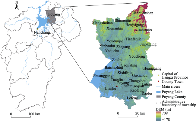
Fig. 1 Location of Poyang County
Poyang County is the second largest agricultural county, and a large labor exporting county, in Jiangxi Province. In 2014, Poyang County was listed as one of the directly administered counties in Jiangxi Province. By the end of 2016, Poyang County had a population of 1.33 million residents, and the urbanization rate reached 41.12%.
The county has sufficient cultivated land resources, with a total area of 720 km2 of cultivated land. Poyang has less cultivated land per capita, and the contradiction between people and land is relatively prominent. From 2000 to 2015, the proportion of rural house sites in Poyang County ranged from 2.10% to 2.40%.
According to Tian’s research on the dense areas of rural residential areas in China, Poyang is considered a relatively high-density area among the rural residential areas (Tian et al., 2003).

2.2 Data collection and questionnaire design

2.2.1 Data collection
To fully reflect the situation of the residential land function transformations in the case study area, a questionnaire survey was conducted and relevant statistical data were collected.
The statistical data were mainly from Poyang County statistical yearbook, and primarily included the total population, urbanization rate and financial revenue of each township in Poyang County.
Poyang County field questionnaires were supported by the national project. In July 2017, the research team conducted a week-long field survey in 29 townships on the transformation of rural residential land in Poyang County.
The survey was collected by a stratified random sampling method. According to the distance from the township government location, we selected each town in which to conduct random interviews. Our team distributed a total of 646 questionnaires and collected all 646 questionnaires, which yielded an effective questionnaire rate of 89.78%.
2.2.2 Survey design
The survey was divided into two parts, with 66 questions. All of the questions were objective questions, including 26 objective choice questions and 40 objective filling questions. The first part included four types of questions, which mainly covered the basic characteristics of family members, such as total number of family members, resident population, education level, profession, etc. The second part contained six kinds of questions. This part investigated the rural homestead utilization and housing situation, such as housing useful life, housing construction expenditures, housing structure and building area, housing conditions and so on.
Based on the time points of 2000 and 2017, the questionnaire content was designed around the population capability function, asset function and residential function of the rural homesteads. The questionnaire covered a wide range of topics, and the surveys were designed from many different angles to reflect the multitude of functions of rural homesteads.
2.2.3 Data processing
In the field survey, a total of 58 villages in 29 towns were investigated, and 580 questionnaires were obtained after screening to exclude invalid questionnaires. All questionnaires contained the basic conditions of the households and the houses. The overall data were relatively comprehensive, which could better reflect the current situation of rural homestead utilization in 2000 and 2017. We tested the reliability of the questionnaire data and the α coefficient was 0.796. Compared with the rural homestead functional transformation index system, the adaptive data was sorted out. The index data for the statistical summary was standardized by the extremum method, and data preprocessing was completed.

3 Study methods

3.1 Coordinated transition model

The main method used in this study is the coordinated transition model. The essential prototype of the model is the prism model. This model relies on the lever principle, and the three-dimensional stereogram is used to express the functional transformation degree. The stereogram is used to express the coordinated transformation degree among the three types of homestead functions.
The term “coordinated transformation degree” has two layers of meaning: the functional transformation degree, and the integrated coordination degree (Long et al., 2012; Song, 2017). This model provides a comprehensive investigation of the functional transformation of rural homesteads, to evaluate the degree of coordinated transformation of the rural homesteads.
As shown in Fig. 2, the three sides of the prism represent the population capability function transformation (PT), asset function transformation (AT) and the residential function transformation (RT). The vertical direction along the three lateral edges indicates that the degree of transformation of the relevant subsystem is increasing, and the volume size of the vertex sphere indicates the degree of transformation. Points A, B, C and D are the four scales (from small to large) on the central axis of the prism.
According to the principle of leverage, the horizontal distance from the transformation degree of each element to the straight line of the coordination transformation degree is analogous to the force arm in the action of a lever (Li and Long, 2014). The greater the distance means the stronger the force exerted by this element to the coordination transformation degree, and the greater its contribution.
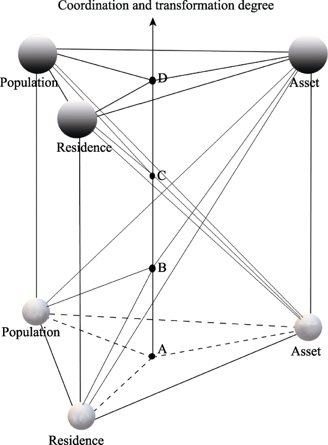
Fig. 2 Coordinated transition model
The formulas of the coordinated transition model (Li and Long, 2014) are calculated as follows:
${{X}_{zi}}=\underset{j=1}{\overset{m}{\mathop \sum }}\,{{w}_{ij}}\times {{X}_{zij}}$
$FT=\alpha \times PT+\beta \times AT+\gamma \times RT$
$IC=\left( PT\times AT\times RT \right)/{{\left[ \left( PT+AT+RT \right)/3 \right]}^{3}}$
$CT=\sqrt{FT\times IC}$
where the Xzi refers to the index value of the i criterion layer in z town, which can represent the transformations of the population capability function (PT), asset function (AT) and residential function (RT); wij is the weight of j index in i criterion layer, m is the number of indicators in each criterion layer, Xzij is the value of the j index of the i criterion layer in z town after standardization. The rural homestead function transformation degree (FT) is the comprehensive evaluation index of the rural homestead functional transformations of population capability function, asset function, and residential function, which reflects the synthetic level of the rural homestead function transformation. α, β and γ are the weight coefficients of the population capability function transformation, asset function transformation and residential function transformation. They can measure the transformation degrees of the respective functions. The integrated coordination degree (IC) is a model for calculating the elements of the “population-asset-residence” coordination degree. The integrated coordination degree can measure the coordination degree of the transformations among the elements and its values range between 0 and 1. The maximum value means the best coordination state, while a smaller degree indicates a more uncoordinated state. The coordinated transformation degree (CT) measures the degree of functional transformation and coordination of rural settlements.

3.2 Establishment of the functional transformation index system

3.2.1 Functional transformation index system
In this study, the function of housing land that could accommodate people’s living was called the population capacity function, while the asset function signified construction investment and value. The most basic function of the homestead was the residential function. There were two levels in the functional transformation index system; the first level reflected the three kinds of function types and the second level was the concrete manifestation of the homestead functions. The second level included qualitative and quantitative forms. Qualitative secondary indexes included education level, housing structure, housing decoration, health conditions and information conditions. There were seven quantitative indicators remaining. The above 5 qualitative secondary indicators are valued with different scores according to different grades, and the specific assignments are shown in Table 1.
Table 1 Functional indicator system of rural homestead
Primary index Index description
Population capability function A1: Total number of households
A2: Number of permanent residents
A3: Number of households involved in work
A4: Total number of family support
A5: Comprehensive score of family education (Below primary school, 0; primary school, 5; junior high school, 15; senior high school, 20; college and above, 25)
Asset function B1: Total cost of building a house
B2: Floor area of the house
B3: Service life of the house
Residential function C1: Floor number and building structure (Civil, 5; brick wood, 10; brick concrete, 20; frame, 40)
C2: House interior floor, doors and windows, interior walls (Floor: soil, 5; concrete, 10; tile floor, 20; doors and windows: wood, 5; metal, 10; other, 20; interior wall: no or soil, 5; lime or imitation porcelain, 10; wall paint or other, 20)
C3: Availability of household tap water and flush toilets (Sanitary conditions: independent kitchen, 10; tap water, 10; flush toilet, 10; independent septic tank, 10)
C4: Home TV, network communication conditions (Wireless satellite, 5; cable analog, 10; cable digital, 15; network TV, 20)
Based on the connotations of these functions, we constructed a functional transformation index system of the rural homesteads in the case study area. Moreover, we did a comparative evaluation of the functional transformation indexes in 2000 and 2017. The function index system is shown in Table 2.
Table 2 Rural homestead functional transformation index system
Transformation type Variable Index description
Population capability function X1 Changes in the total number of households
X2 Changes in the number of permanent residents
X3 Changes in the number of households involved in work
X4 Changes in the total number of family support
X5 Changes in comprehensive education level of family education
Asset function X6 Changes in all-in cost of building house
X7 Changes in housing construction area
X8 Changes in the service life of the house
Residential function X9 Changes in building structure and floor numbers
X10 Changes in indoor doors, windows, and other housing decoration
X11 Changes in the availability of household sanitary facilities such as tap water and flushing toilets
X12 Changes in information conditions such as television and network communications
3.2.2 Weights of the functional transformation indicators
The main methods to determine the weights in the multi-index evaluation model are the objective weighting and subjective weighting methods (Wang et al., 2012). The mean square difference method (MSD), which is a kind of objective weighting method, was used in this study to determine the weight of each indicator in this study. This method does not rely on human subjective judgement, and it is a method to determine the weights by normalizing the mean square error of each index on the basis of finding the mean square deviation of each index (Qu, 2014). The MSD is determined according to the dispersion degree of random variables. The greater the degree of dispersion of the index value, the smaller the information entropy. The calculation steps are as follows:
(1) Data standardization processing
The data of the index layer are standardized so that the value range of the index is within 0-1. The positive index is processed by the forward extreme value, while the negative index is processed by the reverse extreme value.
${{X}_{zij}}=\left\{ \begin{array}{*{35}{l}} \frac{{{x}_{zij}}-{{x}_{\text{min}}}}{{{x}_{\text{max}}}-{{x}_{\text{min}}}}\ \ \ \ \text{(Positive}\ \text{index)}\ \ \ \ \ \ \ \ \\ \frac{{{x}_{\text{max}}}-{{x}_{zij}}}{{{x}_{\text{max}}}-{{x}_{\text{min}}}}\ \ \ \ \text{(Negative}\ \text{index)} \\ \end{array} \right.$
where the Xzij is the value after standardization, xzij is the initial value of the j index of the i criterion layer in z town, xmin is the minimum value of the j index in the i criterion layer, xmax is the maximum value of the j index in the i criterion layer, 1≤zn;1≤jm;1≤ik, n is the number of towns in the Poyang county, m is the number of indicators in each criterion layer, k is the number of criterion layers.
(2) Formula of index layer weight:
${{E}_{ij}}=\frac{1}{n}\underset{z=1}{\overset{n}{\mathop \sum }}\,{{X}_{zij}}$
where, the Eij refers to the average value of j index in i criterion layer, Xzij is the value of the j index of the i criterion layer in z town after standardization, n is the number of towns in the Poyang county.
${{V}_{ij}}=\sqrt{\underset{z=1}{\overset{n}{\mathop \sum }}\,{{({{X}_{zij}}-{{E}_{ij}})}^{2}}}$
where, the Vij refers to the variance of j index in i criterion layer, Eij is the average value of j index in i criterion layer, Xzij is the value of the j index of the i criterion layer in z town after standardization, n is the number of towns in the Poyang county.
${{w}_{ij}}={{V}_{ij}}/\underset{j=1}{\overset{m}{\mathop \sum }}\,{{V}_{ij}}$
where the wij refers to the weight of j index in i criterion layer, Vij is the variance of j index in i criterion layer, m is the number of indicators in each criterion layer.
(3) Formula of criterion layer weight:
${{E}_{i}}=\frac{1}{n}\underset{z=1}{\overset{n}{\mathop \sum }}\,{{X}_{zi}}$
where the Ei stands for the average of the i criterion level, Xzi refers to the index value of the i criterion layer in z town, n is the number of towns in the Poyang county.
${{V}_{i}}=\sqrt{\underset{z=1}{\overset{n}{\mathop \sum }}\,{{({{X}_{zi}}-{{E}_{i}})}^{2}}}$
where the Vi stands for the variance of the i criterion level, Xzi is the index value of the i criterion layer in z town, Ei is the average of the i criterion level, n is the number of towns in the Poyang county.
${{W}_{i}}={{V}_{i}}/\underset{i=1}{\overset{k}{\mathop \sum }}\,{{V}_{i}}$
where the Wi stands for the weight of the i criterion level, Vi stands for the variance of the i criterion level, k is the number of criterion layers.
The weight value of each level index is shown in Table 3.
Table 3 Summary of weights of indicators for functional transformation of rural homestead
Criterion layer Weight Index layer Weight
Population capability function 0.306 X1 0.193
X2 0.196
X3 0.233
X4 0.197
X5 0.181
Asset function 0.317 X6 0.389
X7 0.327
X8 0.284
Residential function 0.377 X9 0.290
X10 0.215
X11 0.244
X12 0.251

3.3 Evaluation standard of coordination transformation degree

To allow a unified comparison of the index values of coordination transformations in different periods, the quartile method was used to classify the indexes of the 29 towns in Poyang County in the two periods. This study sets the values of 25% (1 quartile), 50% (median) and 75% (3 quartile) as the interval critical values of the classification. The numerical value is divided into I-IV levels, ranking from low to high. The higher the level is, the better the coordination transformation degree. The classification criteria are shown in Table 4.
Table 4 Classification of functional transformation index values using the quartile method
Level PT AT RT FT IC CT
(0.0656, 0.1004] (0.0188, 0.0704] (0.0180, 0.1662] (0.2999, 0.3869] (0.2765, 0.7041] (0.3240, 0.5179]
(0.1004, 0.1408] (0.0704, 0.0921] (0.1662, 0.1941] (0.3869, 0.4165] (0.7041, 0.7897] (0.5179, 0.5902]
(0.1408, 0.1601] (0.0921, 0.1180] (0.1941, 0.2192] (0.4165, 0.4690] (0.7897, 0.8972] (0.5902, 0.6170]
(0.1601, 0.2144] (0.1180, 0.1867] (0.2192, 0.3280] (0.4690, 0.5740] (0.8972, 0.9576] (0.6170, 0.7388]

4 Analysis of the functional transformation of rural homesteads

4.1 Analysis of functional transformation

The functional transformation degree is a measure for calculating the transformation rate of the internal subsystem of rural homestead functions. It also refers to the comprehensive performance of the functional characteristics of rural homesteads under the influence of social, economic, and other internal factors in the process of transformation and development. In contrast, the rural homestead has experienced 17 years of evolution, and during that time its functional index has been greatly improved in the whole region. Moreover, it was obvious that the functional transformation degree distribution pattern has spatial differences.
According to Table 4, the functional transformation degree of rural homestead and the functional transformation index of each subsystem from 2000 to 2017 were divided into four levels: I-IV. The spatial pattern of the functional transformation index of the subsystems in the study area are shown in Fig. 3. The functional transformation index of the population capacity function, asset function and residential function contained roughly equal numbers of towns.
Among these towns, the high value areas of the population capability function transformation were distributed in 7 towns, including Xiejiatan, Jiantianjie, Youcheng, and others, while the low value areas were distributed in eight towns in southern and northwestern parts of the county. The high value areas of the asset function transformation were distributed in seven towns, including Tianfanjie, Youdunjie and Lutian, while the low value areas were distributed in Shimenjie, Jinpanling and other towns which were located the south-central part of the county or close to the county boundary. The high value areas of the residential function transformation were distributed in Shimenjie, Xiejiatan, Youdunjie which were in the northern part of the county, as well as Shuanggang, Poyang, Lutian and Baishazhou which are located in the southern part. The low value areas were distributed in eight towns in the south-central and northeastern regions. In general, the transformation of population capacity, asset and residence did not show homogeneity, and the spatial difference was obvious. The spatial pattern of the rural homestead function transformation index in the study area is shown Fig. 3.
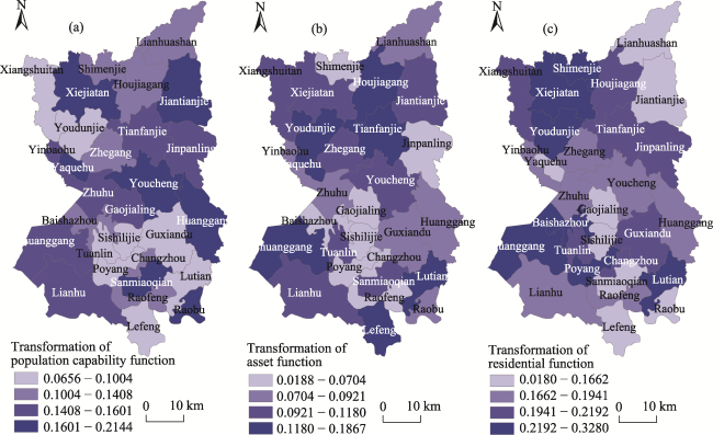
Fig. 3 Transformation of spatial pattern of functional subsystems in rural homestead
Among these towns and as seen in Fig. 4a, the Level-I functional transformation degree included eight towns, such as Lianhuashan, Lefeng, Raofeng, Changzhou, Guxiandu,Sishilijie, Gaojialing and Tuanlin. The Level-II functional transformation degree included seven townships, such as Raobu, Sanmiaoqian, Jinpanling, Zhegang, Yaquehu, Yinbaohu and Xiangshuitan. The Level-III functional trans- formation degree included seven towns, such as Shimenjie, Jiantianjie, Zhuhu, Baishazhou, Huanggang and Poyang. The Level-IV level included seven towns, such as Xiejiatan, Houjiagang, Youdunjie, Youcheng, and others. The level distribution of the rural homestead functional transformation degree in Poyang County was relatively uniform, and the spatial distribution of each level was obviously concentrated and continuous.

4.2 Analysis of integrated coordination degree

The integrated coordination degree was applied to judge whether the transformation rates of population capacity, assets and residence functions were consistent in the functional transformation of rural homesteads. The more coordinated the transformations of these functions was, the higher the integrated coordination value would be. When the transformation rates of these functions were fast or slow at the same time, then the comprehensive coordination degree would show a high value. When the transformation rate of any one of the functions was unusually fast or slow, the degree of coordinated transformation would be low. Fig. 4b shows the general spatial pattern of the coordinated transformation index of rural homesteads in the study area. The integrated coordination degree demonstrated the spatial characteristics of large agglomeration and small dispersion. Throughout the area, the Level-I integrated coordination degree included Xiangshuitan, Yaquehu, Jinpanling, Gaojialing and 4 other towns. The Level-II included Lutian, Raofeng, Tuanlin and 4 other towns. The Level-III included Lefeng, Raobu, Huanggang, Youcheng, Zhuhu and 2 other towns; while the Level-IV included Shuanggang, Lianhu, Sanmiaoqian, Zhegang and 3 other towns.
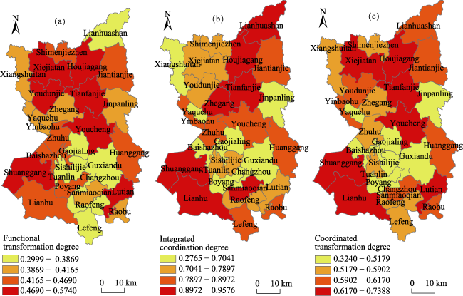
Fig. 4 Coordination spatial pattern of the functional transformation of rural homestead

4.3 Analysis of the coordinated transformation degree

Previous studies have shown that the degree of functional transformation and integrated coordination could not comprehensively estimate the functional transformation of rural homesteads in a case study. In order to reveal the sustainability of the functional transformation of rural homesteads, this study applied the coordinated transformation degree to make an overall evaluation. This metric thoroughly represents the functional transformation in Poyang from the aspects of “transformation” and “coordination”.
The high-value area of coordinated transformation represented either the high degree of functional transformation or the well-developed coordination of population-asset-residence functional transformation, or that the county was in a state of high coordination of high-speed transition at the same time and vice versa. The results are shown in Fig. 4c. Viewed as a whole, the degree of integrated coordination and coordinated transformation have similar spatial distribution patterns, in that high-value areas were distributed in the northeast and southwest of the county, while the low-value areas were mainly distributed in the south-central part of the county, such as Baishazhou, Jinpanling and other border towns.
Across the county, the towns had higher values in functional transformation degree than in integrated coordination degree, therefore the coordinated transformation degree of these towns was advanced, was as seen in Houjiagang, Youcheng, Shuanggang, Lianhu and Sanmiaoqian and seven other towns. In other words, the coordinated transformation degree was low in the remaining towns, such as Jinpanling, Xiangshuitan, Gaojialing, Guxiandu, Poyang and Baishazhou and eight other towns due to their much lower values in the functional transformation degree and integrated coordination degree.

5 Conclusions

In the process of rapid urbanization in China, profound changes have taken place in the rural system. The key elements of rural development, such as population, capital and land, have undergone non-agricultural transfer, a process which has promoted the dramatic transformation of rural land use. As the main type of land use in rural areas, this study divided the function of rural homesteads from the perspective of promoting homestead functions. Taking Poyang County as a study case to carry out field surveys, we studied the function and coordination transformation of rural homesteads from the aspects of “quantity”, “speed” and “quality”. The main conclusions are as follows:
(1) Poyang County has accelerated the development of new urbanization since the 11th Five Year Plan of economic development. Relying on the construction of Expressway and railway systems, Tianfanjie and Huanggang were built into the sub-center of Poyang County. At the same time, Xiejiatan, Yudunjie, Gaojialing, Shimenjie, Raobu, Guxiandu, Shuanggang, Lefeng and 8 other townships have also been developed to a certain extent. The spatial distribution of the functional transformation degree was highly coupled with the spatial distribution of the urbanization development in Poyang County. The high value areas of the functional transformation degree were mainly distributed in the belt areas in the northern part of the county, while the low value areas were mainly distributed in the south and northwest. Around Poyang Town, a “collapse area” with a low value of functional transformation degree has been formed.
(2) The integrated coordination degree of rural homesteads was characterized by large agglomeration and small dispersion in space. The high value and low value areas of the comprehensive coordination degree formed an “anti-C” shape geographically. In the northeast and southwest of county, the consistency of the transformation speed of the functional subsystem of rural homesteads was the best. While in the south of the “anti-C” area, the consistency of the transformation speed was poor. There was a similar spatial distribution pattern between the integrated coordination degree and the coordinated transformation degree. While, the difference in the spatial layout of the towns in the north of the county, the towns with the best transformation of rural homesteads in the region were mainly distributed in the mountainous area in the northeast and in the southwest area near Poyang Lake. To a certain extent, there was a phenomenon of population, assets, etc., being transferred to the cities and towns in the central county areas and the towns at the edge of the county.
(3) From the micro level, based on the field investigation, this paper constructed the coordinated transformation degree model and evaluation index system around the three functional connotations of rural homestead population carrying capacity, assets, and residence. Also, we considered the coordination of the rural homestead function transformation from the perspectives of “transformation” and “coordination”, comprehensively. This research has a certain reference value for strengthening the internal efficiency management of rural homesteads. In essence, the results could be references for accelerating the integration of rural resources and the flow of urban and rural elements.
Although this research explored the coordination of the internal function transformation of homesteads through field investigation and drew corresponding conclusions, further research is still needed. Due to the time, energy and difficulty of data acquisition, this research mainly focused on the three main functions of rural homesteads. However, the functional connotation of rural homesteads is more than that, and it is worthwhile to expand the scope in the future. Rural revitalization, rural homestead transfer and other rural land management systems are constantly accelerating the process of rural transformation. Studying the relationships between rural homestead function transformation and social development could benefit from more research.
1
Cao Q, Sarker M N I, Sun J Y . 2019. Model of the influencing factors of the withdrawal from rural homesteads in China: Application of grounded theory method. Land Use Policy, 85: 285‒289.

2
Chen Y, Li W F, Ren L Y , et al. 2014. Changes in the distribution of rural residential land on a coastal plain. Resources Science, 36(11): 2273‒2281. (in Chinese)

3
Feng Y B, Yang Q Y . 2015. A review of research on the rural homestead evolution process and its regulation. Resources Science, 37(3): 442‒448. (in Chinese)

4
Fu C . 2017. The evaluation of rural territorial functions: A case study of Henan, China. Journal of Resources and Ecology, 8(3): 242‒250.

DOI

5
Gao X L, Jue J . 2013. Estimation of rural housing structure and its vulnerability in China. Journal of Geographical Sciences, 23(1): 179‒191. (in Chinese)

DOI

6
Kong X S, Liu Y L, Jiang P , et al. 2018. A novel framework for rural homestead land transfer under collective ownership in China. Land Use Policy, 78: 138‒146.

7
Jiang G H, He X, Qu Y B , et al. 2016. Functional evolution of rural housing land: A comparative analysis across four typical areas representing different stages of industrialization in China. Land Use Policy, 57: 645‒654.

8
Li T T, Long H L . 2014. Rural development from viewpoints of transformation and coordination: A case in Shandong Province. Progress in Geography, 33(4): 531‒541.

(in Chinese) Li Y R, Qiao L Y, Wang Q Y , et al. 2020. Towards the evaluation of rural livability in China: Theoretical framework and empirical case study. Habitat International, 105: 102241. DOI: 10.1016/j.habitatint.2020.102241.

9
Liu X Q, Bi R T, Gao Y . 2011. The analysis of spatial distribution and optimization on rural settlement in upland half a mountainous using GIS technology. Economic Geography, 31(5): 822‒826. (in Chinese)

10
Long H L, Li T T . 2012. The coupling characteristics and mechanism of farmland and rural housing land transition in China. Journal of Geographical Sciences, 22(3): 548‒562. (in Chinese)

11
Lu M Q, Wei L Y, Ge D Z , et al. 2020. Spatial optimization of rural settlements based on the perspective of appropriateness-domination: A case of Xinyi City. Habitat International, 98:102148. DOI: 10.1016/j.habita tint.2020.102148.

12
Ma W Q, Jiang G H, Li W Q , et al. 2019. Multifunctionality assessment of the land use system in rural residential areas: Confronting land use supply with rural sustainability demand. Journal of Environmental Management, 23(1): 1‒73.

13
Peerzado M B, Magsi H, Sheikh M J . 2019. Land use conflicts and urban sprawl: Conversion of agriculture lands into urbanization in Hyderabad, Pakistan. Journal of the Saudi Society of Agricultural Sciences, 18: 423‒428.

14
Qi Q, Xu X F, Yang C M , et al. 2020. Study on the mechanisms and modes of functional transformation of rural residential land under the background of rural revitalization: Case analysis of typical villages. China Land Science, 34(6): 84‒9. (in Chinese)

15
Qu L T . 2014. Ecological function analysis of agricultural land in Hunan Province based on mean square error and TOPSIS model. Scientific and Technological Management of Land and Resources, 31(5): 14‒20.

16
Sikorski D, Latocha A, Szmytkie R , et al. 2020. Functional changes in peripheral mountainous areas in east central Europe between 2004 and 2016 as an aspect of rural revival? Kłodzko County case study. Applied Geography, 122:102223. DOI: 10.1016/j.apgeog.2020.102223.

17
Song X Q . 2017. Discussion on land use transition research framework. Acta Geographica Sinica, 72(3): 471‒487. (in Chinese)

18
Song Y H, Wang J L, Hao S M , et al. 2014. The Energy-related impacts of social factors of rural houses in southwest China. Energy Procedia, 57: 1555‒1564.

19
Su K C, Hu B Q, Shi K , et al. 2019. The structural and functional evolution of rural homesteads in mountainous areas: A case study of Sujiaying Village in Yunnan Province, China. Land Use Policy, 88:104100. DOI: 10.1016/j.landusepol.2019.104100.

20
Sun W B, Luo Y Q, Zhou W J , et al. 2012. Parametric study on bearing capacity of CFST members considering the concrete horizontal casting effect. Steel and Composite Structures, 13(3): 259‒275.

21
Tian G, Liu J, Zhuang D . 2003. The temporal-spatial characteristics of rural residential land in china in the 1990s. Acta Geographica Sinica, 58(5): 651‒658. (in Chinese)

22
Wang W D, Guo J, Fang L G , et al. 2012. A subjective and objective integrated weighting method for landslides susceptibility mapping based on GIS. Environmental Earth Sciences, 65(6): 1705‒1714.

23
Wu Y Z, Mo Z B, Peng Y , et al. 2018. Market-driven land nationalization in China: A new system for the capitalization of rural homesteads. Land Use Policy, 70: 559‒569.

24
Xu H Z, Liu Y X . 2016. Policy implications and impact of household registration system on peasants’ willingness to return rural residential lands: Evidence from household survey in rural China. Panoeconomicus, 63(1):135-146.

25
Zhang B L, Zhang F R, Zhou J , et al. 2015. Functional evolution of rural settlement based on micro-perspective: A case study of Hetaoyuan Village in Yishui County, Shandong Province. Scientia Geographica Sinica, 35(10): 1272‒1279. (in Chinese)

26
Zhang K H, Song S F . 2003. Rural-urban migration and urbanization in China: Evidence from time-series and cross-section analyses. China Economic Review, 14: 386‒400.

27
Zhao Q L, Jiang G H, Ma W Q , et al. 2019. Social security or profitability? Understanding multifunction of rural housing land from farmers’ needs: Spatial differentiation and formation mechanism—Based on a survey of 613 typical farmers in Pinggu District. Land Use Policy, 86:91-103.

Outlines

/