Land Use Efficiency

Evolution Characteristics of Urban Land Use Efficiency under Environmental Constraints in China

  • SHI Jiaying ,
  • HE Yafen , *
Expand
  • Institute of Ecological Civilization, Jiangxi University of Finance and Economics, Nanchang 330013, China
*HE Yafen, E-mail:

SHI Jiaying, E-mail:

Received date: 2020-09-23

  Accepted date: 2020-11-25

  Online published: 2021-05-30

Supported by

The National Natural Science Foundation of China(41961035)

The Natural Science Foundation in Jiangxi Province(20202BAB213014)

The Technology Foundation of Jiangxi Education Department of China(GJJ180285)

The Humanities and Social Sciences Research Project of Jiangxi Universities(GL19206)

Jiangxi University of Finance and Economics Student Research Project(20200613133356832)

Abstract

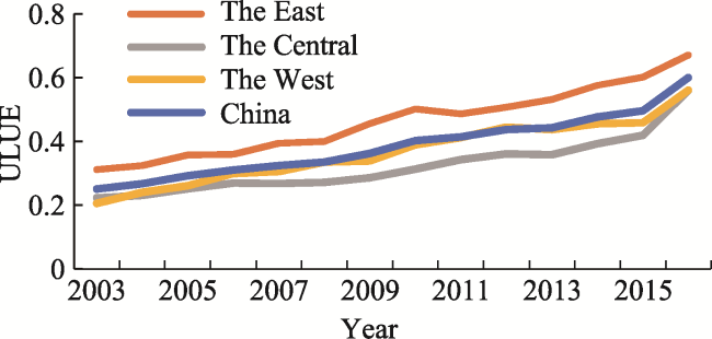
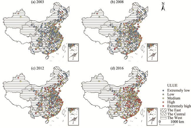
In the context of high-quality economic development and coordinated regional development, this paper measures the urban land use efficiency of 275 prefecture-level cities in China from 2003 to 2016, taking into account the unexpected output (environmental pollution), and explores the temporal and spatial evolution of urban land use efficiency through kernel density estimation and spatial autocorrelation analysis. The results show that: (1) From 2003 to 2016, China’s urban land use efficiency showed an overall fluctuating growth, but it remained at a low level. The mean value of urban land use efficiency has been gradually decreasing in east, west and central regions. (2) In the whole country and the eastern, central and western regions, the regional differences have been increasing, and the efficiency values of the whole country and the east have become polarized. (3) Urban land use efficiency shows a weak spatial positive correlation, but the degree of spatial agglomeration is increasing. High-high agglomeration areas are mostly distributed in the southeastern coastal areas, and extend into the central region, while most of the high-low polarized areas are the capital cities of the central and western regions. The low-high depressed areas are scattered around the high-value accumulation areas, some of which have turned into high-high agglomeration areas during the study period, while the low-low homogeneous areas are mainly distributed in the central, western and northeastern regions. Therefore, it is proposed that strengthening the utilization of urban stock land, strengthening the regional cooperation mechanism, and formulating policies which improve the efficiency of land use are effective ways to promote the intensive and economical use of urban land, as well as regional coordinated development.

Cite this article

SHI Jiaying , HE Yafen . Evolution Characteristics of Urban Land Use Efficiency under Environmental Constraints in China[J]. Journal of Resources and Ecology, 2021 , 12(2) : 143 -154 . DOI: 10.5814/j.issn.1674-764x.2021.02.002

1 Introduction

Against the background of ecological civilization construction, effectively coordinating regional development is one of the major problems China is facing in the new period. The report of the 19th National Congress of the Communist Party of China (CPC) elevated regional coordinated development to a national strategy, and emphasized the establishment of a new and more effective mechanism for regional coordinated development. The General Secretary Xi Jinping has clearly put forward the general idea of regional development under the new situation, that is, “we should adjust and improve the regional policy system in accordance with objective economic laws, give full play to the comparative advantages of each region, promote the rational flow and efficient concentration of various factors, strengthen the economic and population carrying capacity of central cities and urban agglomerations and other areas with economic advantages, and build a regional economic layout with complementary advantages and high-quality development.” Clearly, as a regional unit, the development of a city is an important part of regional coordination. Additionally, as a spatial carrier of urban population expansion and industrial development (Zhou et al., 2016), urban land is an important element of urban economic development, which is closely related to regional development. From 2003 to 2016, China’s urbanization was booming. During this period, urban land area continued to increase and expand dramatically, but the utilization efficiency remains relatively low. The problems of land use, such as a sharp decrease of cultivated land (Zhang et al., 2016) and environmental pollution (Li et al., 2017b; Huang and Du, 2018), are becoming increasingly prominent. Especially in cities with high pollution emissions, the harm caused by pollutants to the urban human settlement environment should not be underestimated. It is not uncommon for these modes of development to gain temporary economic growth at the expense of resources and the environment, but this strategy restricts regional sustainable development and threatens regional ecological security. Since there has not been a unified national market for the factors of production for a long period of time (Lu et al., 2016), and because the natural resource endowments vary from region to region, there are also gaps in factor inputs, resource allocation, economic development and environmental governance, and these gaps are mainly reflected in the process of urbanization development as a very large regional differences in urban land use efficiency. Therefore, considering the environmental constraints, it is necessary to clarify the current situation of urban land use efficiency in the central cities and urban agglomerations, to summarize the regional development characteristics of urban land use efficiency, and to elucidate the temporal and spatial evolution patterns of urban land use efficiency in China, all in order to achieve regional coordinated and high-quality development from the perspective of improving urban land use efficiency. On the one hand, these measures carry out the overall distribution pattern of urban land use efficiency, clarify the development potential of urban land in each region and the disadvantages of traditional land use, and sort out the comparative advantages of regional development. On the other hand, they reflect the response path and functional relationship of the urban land use system to regional social and economic development, and summarizes the objective development law of urban land use efficiency for regional coordinated development. Thus, we can underscore the key point of improving the efficiency of urban land use at the regional level and within it, and provide the scientific basis that allows the government to optimize the allocation of regional land resources, develop the construction of ecological civilization and take the path of scientific sustainable and coordinated development.
At present, domestic and foreign scholars have carried out a great deal of research on urban land use efficiency from three main perspectives.
(1) According to the connotation and evaluation system of urban land use efficiency, some scholars define the urban land use efficiency as the economic output per unit of land use, and choose a single economic index to estimate it (Li et al., 2014; Zhao et al., 2015); some others believe that urban land use efficiency is affected by endogenous agglomeration economic conditions and exogenous resource endowment, and economic and social variables are selected to construct the index system (Zhou et al., 2013; Zhang et al., 2019a); while some pay attention to the coordination of the whole system of economy, society and ecology of land use, construct a more perfect index system, and consider the negative benefit of land use by adding the ecological negative index (Li et al., 2017a; Liang et al., 2019). Urban land is the spatial carrier of urban economy, society and ecology (Zhao et al., 2017). The purpose of improving urban land use efficiency is to maximize land use efficiency under the restriction of sustainable land use. Therefore, it not only emphasizes the maximization of economic and social output, but also hopes to realize the minimization of unexpected outputs, such as environmental pollution.
(2) From the perspective of research methods, they mainly include parametric analysis and non-parametric analysis. The parametric analysis approach uses a production function to fit the data, which needs to construct a production function for parameter estimation to determine the optimal production frontier. Therefore, the accuracy of the result depends on whether the pre-set production function is consistent with the actual situation, and this method is only suitable for multi-input single-output problems. For example, Jin et al. (2018) used Stochastic Frontier Analysis (SFA) to construct a Cobb-Douglas production function to measure the efficiency of urban land use in the Yangtze River Economic Zone. The most widely used non-parametric method is data envelopment analysis (DEA), which measures the relative efficiency of multiple-input and multiple-output decision-making units in a linear programming method, and is not restricted by the form of the production functions. Its main disadvantage is that, unlike the SFA, it cannot separate the statistical error from the efficiency loss. For example, Fan et al. (2018) and Zhu et al. (2019) used the EBM model and super efficiency SBM model to investigate the land use efficiency of different cities in China in the case of considering undesirable output. However, this method measures the efficiency of the evaluation unit directly, and does not decompose the efficiency of a single input factor.
(3) From the perspective of research, the efficiency of urban land use has been explored in regards to the development process of urbanization (Yang et al., 2017; Masini et al., 2019), industrial integration (Lu et al., 2018a), and regional integration (Lu et al., 2018b). As the research on urban land continues to deepen, scholars are continuously adding other quantitative analysis methods on the basis of efficiency measurement, and some have used the Theil index (Li et al., 2018), coefficient of variation (Yang et al., 2014), spatial autocorrelation analysis (Zhang et al., 2019b) or multiple regression model (Liu et al., 2020; Huang and Wu, 2019; Yu et al., 2019) to quantitatively analyse the spatial-temporal differences and influencing factors of urban land use efficiency at different scales from multiple perspectives.
Many valuable theoretical achievements have been made, but some deficiencies still remain. 1) The definition of urban land use efficiency is not accurate enough. Most studies measure the efficiency of the whole decision-making unit (such as a city), rather than the land use efficiency in the process of urban development. 2) Ignoring the analysis of the evolution of characteristics of urban land use efficiency between regions and within a region, it is difficult to provide objective development laws in urban land use efficiency for the coordinated development of a region. 3) There are a lot of studies that only focus on the economic benefits of urban land use, without considering the coordination of economic, social, and ecological benefits. When measuring urban land use efficiency, these studies didn’t consider undesirable output, that is, environmental constraints.
Based on these limitations of the existing research, this paper adds undesirable output to the evaluation index system, and uses that system to measure the efficiency of urban land use in China from 2003 to 2016. Based on the current status of urban land use efficiency in China, this paper analyses the characteristics of the temporal and spatial evolution of urban land use efficiency changes between and within regions, revealing the objective economic laws of China’s regional development from the perspective of land use efficiency, in order to provide countermeasures and suggestions for improving urban land use efficiency under the existing environmental constraints and for improving the regional policy system.

2 Methods and indicators

2.1 Methods

2.1.1 SBM-undesirable model
The traditional DEA models, such as the CCR and BCC models, measure inefficiency based on the radial measurement, which only includes the increase or decrease of all input and output factors in the same proportion without considering the relaxation variables (Xie et al., 2015a), and this is inconsistent with the actual situation. A non-radial and non-angular SBM model, based on relaxation variable measurements, was constructed by Tone (2001) to calculate the inefficiency from input and output. In the process of urban land use, the expected output, such as economic benefit, is always accompanied by some undesirable output, such as environmental pollution (Xie et al., 2015b). Therefore, this paper adopts the further refined SBM-undesirable model to measure the urban land use efficiency, and the basic programming equation is:
The land use system of each prefecture-level city is regarded as a single production decision-making unit (DMU). There are N DMUs$(n=\text{1, 2, }\cdots \text{, }N)$; X, Yg and Yb are input, expected output and unexpected output of each DMU; m, s1, s2 are the types of input, expected output and unexpected output; s, sg and sb are slack variables of input, expected output and unexpected output, respectively; $\rho ~\text{(0}\le \rho \le \text{1)}$ is the efficiency value of the evaluated unit; subscript 0 represents the DMU to be solved; and λ is the weight vector. For a specific DMU, if and only if s=0, sg=0, sb=0, that is, ρ =1, then the decision unit is completely effective. If there is a non-zero value among s, sg and sb, then the decision unit is invalid, but it can still be further optimized by adjusting input and output.
In order to solve the problem that the traditional static efficiency cannot be compared vertically, a global-reference model is adopted (Pastor and Lovell, 2005), in which the same city in different periods is regarded as a different DMU, and a production frontier is constructed from the data of the whole study period as the benchmark of the efficiency measurement. After the optimal production frontier is determined and the slack variable of urban land is calculated, the urban land use efficiency (ULUE) is as follows (Zhang, 2014):
where ULUE represents urban land use efficiency, and the urban land input and its slack variable are recorded as Xl ,s-l, respectively.
2.1.2 Kernel density estimation
As a nonparametric estimation, kernel density estimation does not need prior knowledge of the data distribution. It is mainly used to estimate the probability density of random variables and to describe the distribution form of variables by a continuous density curve, and it is a commonly used method to study the disequilibrium distribution (Liu et al., 2020). The density function of the random variable X is assumed to be f(x):
where n is the number of observations, h is the bandwidth, Xi is the observed value, and K(x) is the kernel function, which usually includes the Gaussian kernel, Epanentechnikov kernel or uniform kernel. With Stata13.0, the dynamic evolution of regional differences in urban land use efficiency is studied by Gaussian kernel. The bandwidth is set as default, and the kernel density curves of China and the three regions in the representative years are drawn. The change of ULUE’s distribution is determined by comparing the position, kurtosis and shape of the curve, and the Gaussian kernel function is expressed as follows:
2.1.3 Spatial autocorrelation analysis
Spatial autocorrelation is an effective method for testing whether a certain attribute value of a region is significantly associated with the same attribute value of its adjacent unit, and includes global spatial autocorrelation and local spatial autocorrelation. Global spatial autocorrelation reflects the degree of aggregation of attribute values as a whole. It is generally measured by Global Moran’s I index (Zhang et al., 2017), which is defined as follows:
where I represents Global Moran’s I index, n is the number of regions, xi and xj are the attribute values of regions i and j, respectively, $\bar{x}$ is the average value of the attribute values of the studied area, and wij is the spatial weight matrix.
The value range of global Moran’s I index is [-1,1]. Under a given significance level, if the global Moran’s I index is greater than 0, then there is a positive spatial correlation. A larger value indicates a more obvious the correlation. If I is equal to 0, it means that there is spatial randomness, and a value of less than 0 means that there is spatial negative correlation. A smaller value indicates a greater spatial difference.
The global spatial autocorrelation analysis reflects the overall spatial correlation characteristics, but it cannot point out the specific location the clustering and outliers. Therefore, the local spatial autocorrelation analysis is used for further refinement (Majumdar and Biswas, 2016). The Local Moran’s I index is generally used to measure the degree of aggregation or difference between the attribute values of each regional unit and those of its neighbors, which is defined as follows:
In formula (6), Ii represents the Local Moran’s I index of i, while ${{x}_{i}},\ {{x}_{j}},\ \bar{x}$and wij have the same definitions as in formula (5).

2.2 Selection of input and output indicators

Considering the characteristics of urban land use and its economic, social and ecological benefits, we determined the input and output indexes, and calculated the urban land use efficiency of 275 prefecture-level cities in China from 2003 to 2016. China is divided into the eastern, central and western regions( According to the area division of China’s economic regionalization proposed in the state’s seventh five-year plan, China is divided into the East (Beijing, Tianjin, Hebei, Liaoning, Shanghai, Jiangsu, Zhejiang, Fujian, Shandong, Guangdong, Hainan), the Central (Shanxi, Jilin, Heilongjiang, Anhui, Jiangxi, Henan, Hubei, Hunan), and the West (Inner Mongolia, Guangxi, Sichuan, Chongqing, Guizhou, Yunnan, Tibet, Shaanxi, Gansu, Ningxia, Qinghai, Xinjiang).
) in the analysis. Due to the special natural conditions of Tibet and the difficulty in obtaining the data for Hong Kong, Macao and Taiwan, these areas are not covered in this study. The input-output indicators (Table 1) are selected as follows:
(1)Input indicators. According to the classical production function, capital, land and labor force are selected as input factors, in which capital is expressed by the fixed asset investment in the municipal area, land is represented by the area of the urban built-up area, and labor force is represented by the number of employees in the secondary and tertiary industries.
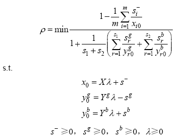
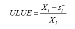
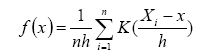
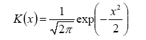
Table 1 Indicators for measuring urban land use efficiency
Indicator
category
Primary
indicators
Secondary indicators
Inputs Capital Fixed assets investment (104 yuan)
Land Built-up area (km2)
Labor force Number of secondary industry
employees (104 person)
Number of tertiary industry
employees (104 person)
Desirable outputs Economic
output
Added value of secondary and tertiary industries (104 yuan)
Undesirable outputs Environmental pollution Industrial wastewater discharge (104 t)
Industrial SO2 emission (t)
Industrial dust emission (t)
(2) Output indicators. This category includes economic output and environmental output (unexpected output). The added value of the secondary and tertiary industries is selected as the economic output index of urban land, and the industrial wastes (industrial wastewater, SO2, smoke), as the direct embodiment of negative externality in the process of urban land use, can be used to express the negative environmental effects. Since the statistical unit in the statistical yearbook is cities rather than municipal districts, the ratio of the total industrial output value of each municipal district to the total industrial output value of the corresponding city is used to convert the emission of the three industrial wastes in the urban areas in the appropriate proportions, and finally the industrial waste emissions of each of the municipal districts are obtained.
The data used in this paper are mainly from the China Urban Statistical Yearbook from 2003 to 2016, and some missing data are supplemented from the China Statistical Yearbook and regional statistical yearbooks, and the economic data used have been converted to 2003 equivalents using the corresponding price indices.

3 Results

3.1 Basic pattern of urban land use efficiency

Based on the SBM-undesirable model, we measured the national and regional urban land use efficiency from 2003 to 2016. The results are shown in Fig. 1. Overall, from 2003 to 2016, urban land use efficiency showed a gradual upward trend, the average efficiency increased from 0.251 to 0.600, and the cumulative growth rate was 139%, but the overall efficiency was at a relatively low level, so there is still much room for improvement. At the sub-regional level, urban land use efficiency in the eastern region rose from 0.312 in 2003 to 0.671 in 2016, an increase of 115% in 14 years, and it showed the highest efficiency among the regions, which was consistently higher than the national average. In the past 14 years, the urban land use efficiency in western China increased the most, from 0.206 in 2003 to 0.561 in 2016, an increase of 172%. The efficiency of the central region rose from 0.223 in 2003 to 0.560 in 2016, an increase of 151%. Except for 2003, the efficiency of the central region is consistently the lowest among the three regions. Comparing the growth rates of urban land use efficiency in the various regions, we found that the growth rate of the western region is the fastest, the central region is the second, and the eastern region is the slowest. However, based on the average efficiency value, the efficiency value of the eastern region is the highest, followed by the western region, and it is lowest in the central region.
Fig. 1 Trends of urban land use efficiency in China and its sub-regions from 2003 to 2016
In order to directly reveal the spatial distribution and general trends of urban land use efficiency in each region from 2003 to 2016, the four individual years of 2003, 2008, 2012 and 2016 were selected as typical (representative) years, the urban land use efficiency was divided into five grades: extremely low, low, medium, high and extremely high by the Natural Break method (Chen et al., 2013), and the spatial distributions of urban land use efficiency in each of the different periods were mapped (Fig. 2). Furthermore, the ratios of efficiency values of different grades in the eastern, central and western regions were calculated (Table 2).
Fig. 2 Spatial distribution of urban land use efficiency in four typical years in China
Table 2 The proportion of urban land use efficiency grades in different regions in the four typical years
Region Level Number of cities in 2003 Proportion(%) Number of cities in 2008 Proportion(%) Number of cities in 2012 Proportion(%) Number of cities in 2016 Proportion(%)
The East Extremely low 18 18.0 20 20.0 15 15.0 7 7.0
Low 31 31.0 25 25.0 27 27.0 17 17.0
Medium 29 29.0 26 26.0 19 19.0 24 24.0
High 20 20.0 19 19.0 15 15.0 19 19.0
Extremely high 2 2.0 10 10.0 24 24.0 33 33.0
The Central Extremely low 47 47.0 39 39.0 40 40.0 16 16.0
Low 35 35.0 38 38.0 22 22.0 24 24.0
Medium 11 11.0 16 16.0 18 18.0 24 24.0
High 4 4.0 4 4.0 10 10.0 20 20.0
Extremely high 3 3.0 3 3.0 10 10.0 16 16.0
The West Extremely low 39 52.0 25 33.3 18 24.0 8 10.7
Low 22 29.3 21 28.0 23 30.7 16 21.3
Medium 10 13.3 17 22.7 10 13.3 26 34.7
High 3 4.0 8 10.7 12 16.0 13 17.3
Extremely high 1 1.3 4 5.3 12 16.0 12 16.0%
In 2003, 2008 and 2012, the urban land use efficiency in China was dominated by low and extremely low grades, accounting for 69.8%, 61% and 52.7%, respectively. By 2016, the urban land use efficiency was mainly in high or extremely high grades, with these two accounting for 41.1%. This trend also reflects the broader transformation of China from attaching primary importance to high-speed economic development in the early stage to an emphasis on high-quality economic development. Since the construction of ecological civilization was put forward, more attention has been paid to green development, and the status of environmental protection has been improved at the same time of continuing economic development, which further improves the efficiency of urban land use. However, the mean value of urban land use efficiency is decreasing in the eastern, western and central regions, with high efficiency values in the east, especially in the southeastern coastal area; and the efficiency values of the central region and west are low, and the low value distribution in the central region is relatively concentrated.
Based on the ratios of efficiency values of different grades in different periods, the distributions of efficiency values of different regions change with time, and the change in urban land use efficiency is the most significant in the east. In 2003, the low-level efficiency values accounted for the highest proportion, reaching 31%. In 2008, that proportion decreased to 25%. In 2012, it grew to 27%. In 2016, the highest proportion of efficiency values in the east was at the extremely high level, reaching 33%. In 2003, 2008 and 2012, the proportion of low-level efficiency value was the highest in the central region, while in 2016, the proportions of efficiency level were more evenly distributed among the five levels. In 2003, 81.3% of the cities in the western region had either low or extremely low efficiency values. In 2008 and 2012, cities with low efficiency accounted for more than 50%. In 2016, cities with medium efficiency accounted for the highest proportion, reaching 34.7%.

3.2 Dynamic evolution of the regional spatial differences of urban land use efficiency

Figure 3 shows the evolution of the characteristics of urban land use efficiency in China and the East, the Central and the West regions. On the national scale: 1) In terms of location, the center of the kernel density curve (i.e., the abscissa value corresponding to the main peak) from 2003 to 2012 is mainly concentrated on the left side, which indicates that the urban land use efficiency was clustered in low values during this period. From 2003 to 2016, the center of kernel density curve showed a trend of rightward shifting, and the shift distance first increased, then decreased and then increased again, which indicated that the overall level of urban land use efficiency kept rising and the average value kept increasing. However, the increase in 2008-2012 is smaller than that in either 2003-2008 or 2012-2016, which may indicate an effect of the 2008 financial crisis. 2) As far as kurtosis is concerned, the height of the kurtosis decreases and the range of the kurtosis increases during the evolution process, which indicates that the regional difference of urban land use efficiency is increasing, but the polarization is alleviated. 3) In terms of shape, the density curve is right skewed, and the right-side area of the main peak is larger, which indicates that there are more cities whose land use efficiency is higher than the average. In 2016, there was an increasing trend in the number of peaks and a multi-polarization trend of the efficiency values.
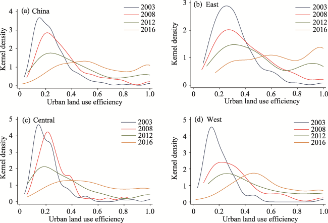
Fig. 3 The dynamic evolution of urban land use efficiency in China
On the regional scale: 1) In terms of location, the center of the kernel density curve in the east moves from the left to the right, indicating that the urban land use efficiency in the eastern region has changed from low value agglomeration to high value agglomeration. The center of the kernel density curve in the central and western regions showed a trend of right-shifting during the study period. The center of the kernel density curve in the central region shifted to the right significantly from 2003 to 2008 and from 2012 to 2016, and it shifted to the left slightly from 2008 to 2012, which shows that the overall level of urban land use efficiency has improved, but the change trend is different. 2) As far as kurtosis is concerned, the heights of the wave crests in the east are always lower than those in the central and west areas, indicating that the distribution of efficiency values in the east is more scattered and the regional differences are greater, the change of wave crest decline in the central region lags behind those in the east and the west, and the kernel density curve in 2008 is similar to that in 2003, which indicates that the change of efficiency value in the central region is slower than that in other regions. 3) As far as the shape is concerned, the kernel density curve in the east changes from a single peak to multiple peaks, and the urban land use efficiency shows polarization, which is mainly due to the further enlargement of the difference of efficiency values between the northeastern region and the southeastern coastal region. There were not multiple peaks in the kernel density curve and no obvious multipolar differentiation in the efficiency values in the study period in the central and western regions.

3.3 Spatial correlation analysis of urban land use efficiency

3.3.1 Global spatial autocorrelation
In order to identify whether there are agglomeration characteristics and evolutionary trends of urban land use efficiency in space, we used ArcGIS to conduct spatial autocorrelation analysis based on the 14 annual sets of efficiency data, which allowed us to characterize the relationship between urban land use efficiency in a given unit and its adjacent units. The inverse distance method was used to construct the spatial weight matrix for calculating the global Moran’s I index of urban land use efficiency (Fig. 4). The results show that the global Moran’s I index of urban land use efficiency is positive at the significance level of 1%, but its value is small. At the beginning of the period, the global Moran’s I index is close to 0, which indicates that the distribution of cities with high (low) urban land use efficiency is non-random and there is a weak spatial agglomeration. On the other hand, the global Moran’s I index volatility increased during the study period, from 0.1014 in 2003 to 0.2217 in 2016, and the positive correlation clustering char-acteristics of urban land use efficiency became increasingly more obvious.
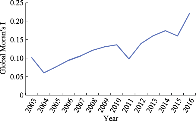
Fig. 4 Global Moran’s I index of urban land use efficiency in China from 2003 to 2016
3.3.2 Local spatial autocorrelation
Global Moran’s I index shows the overall spatial correlation characteristics of urban land use efficiency, but it is unable to determine the specific locations of high and low efficiency values. Therefore, we used the local spatial autocorrelation analysis for further study and mapping of the distribution of aggregation and outliers of urban land use efficiency in different periods (P<0.05). Four clustering types, high-high (H-H), high-low (H-L), low-high (L-H) and low-low (L-L), were identified and their local spatial correlation characteristics are described.
(1) High-High agglomeration areas. The efficiency values of these cities and their surrounding cities are all at a high level, so the differences between adjacent cities are small, and they are mainly distributed in the southeastern coastal areas of Guangdong, Zhejiang, Jiangsu, Shandong, Shanghai, etc. This kind of area has a relatively well-developed economy, good location conditions, and more concentrated capital, technology and population elements. The factor aggregation is conducive to improving the input-output of land units, and promoting the allocation of resources to balance economic development and environmental protection, so that the efficiency of urban land use is always at a higher level. Over time, the spatial spillover effect brought by the external economy has become more obvious, the high-value agglomeration area gradually changed from a scattered distribution to a contiguous distribution, the number of cities involved increased, and the agglomeration became more prominent. It is worth noting that between 2003 and 2008, Kunming and its surrounding areas experienced high value clustering, mainly because the industrial layout of these cities was dominated by the tertiary sector of the economy, and urban development did not depend primarily on the expansion of construction land, so the higher the economic output, the less the environmental pollution. In the later period, under the positive influence of the Yangtze River Delta Economic Zone, the high value agglomeration area further extended to the central region, such as Anhui Province.
(2) High-Low polarized areas. The urban land use efficiency value of this kind of region is high, but the surrounding cities’ efficiency values are low, showing a negative correlation pattern of "oneself is high, periphery is low". Such cities are relatively few, and most of them are provincial capitals in the central and western regions, such as Lanzhou, Xi’an, Zhengzhou, etc. As the core cities in the central and western regions, these cities have a higher priority in the construction and development of the cities. They have relatively concentrated populations and other factors, and have a higher intensity of economic activities, but they have not yet fully experienced the diffusion effect of urban development, and the driving effect on the surrounding cities is not obvious.
(3) Low-High depressed areas. The land use efficiency of these cities is far lower than that of the surrounding cities. The number of cities in this group is small, and they are scattered around the high value gathering areas, mainly in some cities of Guangdong, Jiangsu, Zhejiang and Anhui. Although this kind of city is located in the periphery of a high-value agglomeration area, the urban land use efficiency is not high due to factors such as industrial development, technological innovation ability and population loss, but there is much room for improvement. In the later period, with the influence of industrial transfer and further economic development, some of these cities turned into high-efficiency areas, forming a contiguous distribution pattern of high-value agglomeration areas.
(4) Low-Low homogeneous areas. The land use efficiency of these cities and their adjacent cities are all low, and they are mainly distributed in Gansu, Henan, Shanxi, Shaanxi, Heilongjiang and other central, western and northeastern regions. The economic foundation of such cities is relatively weak, the location advantage is not obvious, they have not broken away from the development pattern of high investment and high pollution for high income, and the ecological benefits of land use have not been paid enough attention. In the later period, with a series of measures to implement the industrial transfer in the east, the central region was the first choice for the transfer of high energy consumption and high pollution industries to inland areas. This role promoted the economic development, but at the same time, the urban construction land expanded further, and the environmental pollution was aggravated. Therefore, the low value gathering areas in Fig. 5 tend to shift from the west to the central region. As a traditional old industrial base, the northeastern region has extensive use of industrial land in old cities, leaving a large amount of idle or inefficient land. While this area is still in the process of economic transformation and development, with insufficient technological innovation capacity and serious population outflow, the slow economic development leads to low efficiency of urban land use and low value agglomeration.
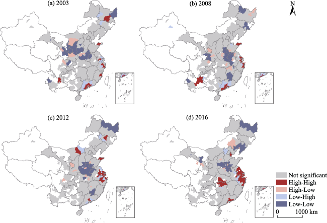
Fig. 5 Local spatial autocorrelation of urban land use efficiency in four typical years in China

4 Discussion

By considering the unexpected output (environmental pollution), this paper establishes an index system for measuring the efficiency of urban land use, and measures the urban land use efficiency under environmental constraints by using the input redundancy of the single element of land in the process of urban development. The results indicate that the urban land use efficiency in China shows a U-shaped spatial distribution with a gradual decrease in the eastern, western and central regions, which is also consistent with the conclusion obtained by Zhang (2014). This paper further compares the spatiotemporal evolution path of urban land use efficiency under a long-term sequence (2003-2016), which reveals the regional differences and the characteristics of differential evolution of urban land use efficiency, and expresses its spatial correlation characteristics in geospatial form. These analyses enrich the research on urban land use efficiency at the national level and provide scientific reference for future regional policy adjustment. However, there are still some deficiencies in this study. Firstly, the evaluation index system of urban land use efficiency involves input and output as well as economic, social and ecological benefits. Due to the limitations of data acquisition, the number of selected indicators is limited, and the selection of evaluation indicators still needs to be improved in combination with the research objectives. Secondly, the factors influencing regional differences in urban land use efficiency have not been further explored, and their quantitative analysis can be adopted in further research. Thirdly, the study of this paper concluded that the spatial agglomeration degree of urban land use efficiency in China has been continuously enhanced, especially in urban agglomerations in high-value agglomerations. In future studies, this result can be further deepened by comparing the land use status of the different urban agglomerations.
Based on the results of the above analysis, in order to improve the efficiency of urban land use, we put forward the following suggestions:
(1) In the process of urban development, it is necessary to strengthen the exploration of the potential of urban stock land and promote the rational flow of production factors. At present, the overall efficiency of urban land use remains at a relatively low level, with considerable room for further optimization. We should change the standard model of urban development of blind expansion, and strictly control the index of new construction land to restrict the speed of urban expansion. In order to tap the potential of urban stock land and improve the level of intensive and economical utilization of urban land, the development path of urban development is forced to turn to the old city reconstruction and the development of idle and land with low effectiveness. At the same time, we are supposed to accelerate the optimization and upgrading of the industrial structure, promote the rational flow of capital and labor, promote the development of emerging industries and the tertiary sector of the economy, enhance the impetus for innovative development, and speed up the construction of high-quality economic development, so as to further improve the efficiency of urban land use.
(2) On the basis of regional differences of urban land use efficiency, regional cooperation mechanisms should be strengthened and policies should be made to improve land use efficiency according to local conditions. High-high agglomeration areas, as the key areas for regional coordinated development, can give full play to their diffusion effects as regional growth centers, and provide their experiences to the other types of areas. There is a large difference in the internal land use efficiency of high-low polarized regions, which are key areas for improving urban land use efficiency. The spatial diffusion effect of core cities should be further utilized, and surrounding cities should be given more technical and industrial support to cultivate new urban agglomerations, and promote regional coordinated development. Low-high depressed areas are mostly located around high-high agglomeration areas, so we should reduce the dependence on capital, land and other factors, change the status quo from a large amount of resource input and strengthen technology input, and when implementing industrial transfer in developed areas, we will take into account the benefits of the ecological environment, raise the threshold for industrial access, and strengthen environmental pollution control. The low-low homogeneous areas should take full advantage of their backwardness, strengthen the endogenous growth power of the city, develop characteristic industries, improve economic benefits, and avoid adverse competition with the big cities. In particular, the old industrial bases in the northeast should actively adjust their industrial structures based on their own good basic conditions, cultivate new economic growth points, and promote the revitalization of the northeast.

5 Conclusions

In this paper, an SBM-undesirable model is used to measure the urban land use efficiency of 275 prefecture-level cities in China from 2003 to 2016. Based on the comparison of urban land use efficiency differences between the eastern, central and western regions of China, the dynamic evolution of spatial differences of urban land use efficiency in those regions are compared through kernel density estimation. Finally, the spatial correlation characteristics of land use efficiency among cities are discussed through spatial autocorrelation analysis, and the conclusions are as follows:
(1) From 2003 to 2016, China’s urban land use efficiency fluctuated and increased, but there were sizeable regional differences. The urban land use efficiency increased from 0.251 to 0.600, but the overall efficiency value remained low, and there was still a large room for improvement. The urban land use efficiency has been gradually decreasing in the eastern, western and central regions. As far as the growth rate is concerned, the west has the fastest growth rate, followed by the central region, and the east is the slowest. From 2003 to 2012, the country’s urban land use efficiency was dominated by low and extremely low grades, and by 2016 it had been converted to high and extremely high grades. In the intervening 14 years, the distribution of efficiency values in the eastern, central, and western regions all changed over time, with the most significant increase in efficiency in the east.
(2) Based on the kernel density function, the evolutionary characteristics of regional differences are summarized. At the national scale, urban land use efficiency has generally increased, but the development speed varies in different periods. At the beginning of the study period, the urban land use efficiency showed low-value agglomeration. In the process of evolution, regional differences were increasing, and the trend of multipolar differentiation appeared at the end of the study period. The overall efficiency levels of the three regions were improved, but their trajectories of change were different. During the entire study period, the position, kurtosis and shape changes of the kernel density curve for each region were different. The regional difference of the east was more obvious than those of the central and western regions, the distribution of efficiency values tended to be polarized, and the change of the central region is slower than those of the other regions.
(3) Urban land use efficiency shows a weak spatial positive correlation, but the degree of spatial agglomeration is increasing. H-H agglomeration regions are mostly distributed in the southeastern coastal areas, and gradually changed from a sporadic distribution to a contiguous distribution, continuously extending to the central region. The number of H-L polarized regional cities is small, and most of them are provincial capitals in the central and western regions. L-H depressed regions are scattered around H-H agglomeration regions, mainly in Guangdong, Jiangsu, Zhejiang and Anhui provinces. Driven by the nearby cities, some of them turned into H-H agglomeration regions. L-L homogeneous regions are mainly distributed in the central, western and northeastern parts of China, and with the shift of industrial gradients, there has been a trend of shifting from the west to the central region.
Generally speaking, during the period of 2003-2016, there are obvious differences in urban land use efficiency among the eastern, central and western regions. However, over time, urban land use efficiency in the various regions has evolved in the direction of improvement. At the same time, within each region, the differentiation of land use efficiency is more obvious, and the efficiency value shows a multi-polarized distribution. Finally, the Yangtze River Delta, Pearl River Delta, Beijing-Tianjin-Hebei and the Urban Agglomeration in the Central Reaches of the Yangtze River are all high-high agglomeration regions.
1
Chen J, Yang S T, Li H W , et al. 2013. Research on geographical environment unit division based on the method of natural breaks (Jenks). ISPRSInternational Archives of the Photogrammetry, Remote Sensing and Spatial Information Sciences, XL- 4/W3:47-50. DOI: 10.5194/is prsarchives-XL-4-W3-47-2013.

2
Fan P F, Feng S Y, Su M , et al. 2018. Differential characteristics and driving factors of land use efficiency in different functional cities based on undesirable outputs. Resources Science, 40(5):946-957. (in Chinese)

3
Huang L, Wu C Q . 2019. Industrial green development efficiency and spatial driven mechanism in cities of the Yangtze River Economic Belt. China Population, Resources and Environment, 29(8):40-49. (in Chinese)

4
Huang Z H, Du X J . 2018. Urban land expansion and air pollution: Evidence from China. Journal of Urban Planning and Development, 144(4):05018017. DOI: 10.1061/(ASCE)UP.1943-5444.0000476.

5
Jin G, Deng X Z, Zhao X D , et al. 2018. Spatio-temporal patterns of urban land use efficiency in the Yangtze River Economic Zone during 2005-2014. Acta Geographica Sinica, 73(7):1242-1252. (in Chinese)

6
Li J, Hu B X, Kuang B , et al. 2017a. Measuring of urban land use efficiency and its dynamic development in China. Economic Geography, 37(8):162-167. (in Chinese)

7
Li L, Dong J, Zhang J F . 2018. Regional difference and formation mechanism of urban land use efficiency in the Yangtze River Economic Belt. Resources and Environment in the Yangtze Basin, 27(8):1665-1675. (in Chinese)

8
Li W B, Wang D Y, Wang Q , et al. 2017b. Impacts from land use pattern on spatial distribution of cultivated soil heavy metal pollution in typical rural-urban fringe of northeast China. International Journal of Environmental Research and Public Health, 14(3):336. DOI: 10.3390/ijerp h14030336.

9
Li Y L, Shu B R, Wu Q . 2014. Urban land use efficiency in China: Spatial and temporal characteristics, regional difference and influence factors. Economic Geography, 34(1):133-139. (in Chinese)

10
Liang L T, Yong Y J, Yuan C G . 2019. Measurement of urban land green use efficiency and its spatial differentiation characteristics: An empirical study based on 284 cities. China Land Science, 33(6):80-87. (in Chinese)

11
Liu H J, Qiao L C, Sun S H . 2020. Spatial distribution and dynamic change of water use efficiency in the Yellow River Basin. Resources Science, 42(1):57-68. (in Chinese)

12
Liu Y S, Zhang Z W, Zhou Y . 2018. Efficiency of construction land allocation in China: An econometric analysis of panel data. Land Use Policy, 74:261-272.

13
Lu X H, Chen D L, Kuang B . 2018a. Coupling effect of industrial integration and urban land use efficiency: Taking the urban agglomeration of the central reaches of the Yangtze River as a case. China Land Science, 32(9):66-73. (in Chinese)

14
Lu X H, Chen D L, Kuang B . 2018b. Indicator system design and regional difference of urban land use efficiency under the background of regional integration: A case of urban agglomeration in the middle reaches of the Yangtze River. China Population, Resources and Environment, 28(7):102-110. (in Chinese)

15
Lu X H, Kuang B, Zhou M . 2016. Spatial inequality and influencing factors of utilization efficiency of urban construction land. China Population, Resources and Environment, 26(11):45-52. (in Chinese)

16
Majumdar D D, Biswas A . 2016. Quantifying land surface temperature change from LISA clusters: An alternative approach to identifying urban land use transformation. Landscape & Urban Planning, 153:51-65.

17
Masini E, Tomao A, Barbati A , et al. 2019. Urban growth, land-use efficiency and local socioeconomic context: A comparative analysis of 417 metropolitan regions in Europe. Environmental Management, 63(3):322-337.

DOI PMID

18
Pastor J T, Lovell C A K . 2005. A global Malmquist productivity index. Economics Letters, 88(2):266-271.

19
Tone K . 2001. A slacks-based measure of efficiency in data envelopment analysis. European Journal of Operational Research, 130(3):498-509.

20
Xie H L, Wang W, Yao G R , et al. 2015a. Spatiotemporal differences and convergence of urban industrial land use efficiency for China’s major economic zones. Acta Geographica Sinica, 70(8):1327-1338. (in Chinese)

21
Xie H L, Wang W . 2015b. Exploring the spatial-temporal disparities of urban land use economic efficiency in China and its influencing factors under environmental constraints based on a sequential slacks-based model. Sustainability, 7(8):10171-10190.

22
Yang Q K, Duan X J, Ye L , et al. 2014. Efficiency evaluation of city land utilization in the Yangtze River Delta using a SBM-undesirable model. Resources Science, 36(4):712-721. (in Chinese)

23
Yang X F, Dai Z Y, Tian S R . 2017. Research on spatiotemporal development and coupling of urbanization and urban land use efficiency: Taking the middle reaches of the Yangtze River Urban Agglomeration as an example. Geomatics & Spatial Information Technology, 40(10):102-104. (in Chinese)

24
Yu J Q, Zhou K L, Yang S L . 2019. Land use efficiency and influencing factors of urban agglomerations in China. Land Use Policy, 88:104143. DOI: 10.1016/j.landusepol.2019.104143.

25
Zhang L X, Zhu D L, Du T , et al. 2017. Spatiotemporal pattern evolvement and driving factors of urban construction land use efficiency using data envelopment analysis. Resources Science, 39(3):418-429. (in Chinese)

26
Zhang W X, Wu Q, Wang B , et al. 2019b. Multidimensional study of specialized agglomeration and diversified agglomeration on urban land use efficiency. China Population, Resources and Environment, 29(11):100-110. (in Chinese)

27
Zhang Y H, Chen J L, Gao J L , et al. 2019a. The impact mechanism of urban land use efficiency in the Yangtze River Delta from the perspective of economic transition. Journal of Natural Resources, 34(6):1157-1170. (in Chinese)

28
Zhang Z H . 2014. Study of Chinese urban land use efficiency. The Journal of Quantitative & Technical Economics, 31(7):134-149. (in Chinese)

29
Zhang Z X, Wen Q K, Liu F , et al. 2016. Urban expansion in China and its effect on cultivated land before and after initiating “Reform and Open Policy”. Science China Earth Sciences, 59(10):1930-1945.

30
Zhao K, Xu T Q, Li P , et al. 2015. Disparities and convergence of land productivity of different scale cities: Based on panel data of 265 cities in China. Journal of Arid Land Resources and Environment, 29(12):1-6. (in Chinese)

31
Zhao X F, Lou J J, Huang X J , et al. 2017. Research progress in urban land use efficiency. Modern Urban Research about Urban Land Intensive Use, ( 6):2-8. (in Chinese)

32
Zhou Y, He C F, Huang Z J , et al. 2013. Geography and urban land use efficiency: Empirical study based on panel data of 277 Chinese cities during 2004-2008. Urban Development Studies, 20(7):19-25, 56. (in Chinese)

33
Zhou Y, Huang X J, Xu G L , et al. 2016. The coupling and driving forces between urban land expansion and population growth in Yangtze River Delta. Geographical Research, 35(2):313-324. (in Chinese)

34
Zhu X H, Zhang P F, Wei Y G , et al. 2019. Measuring the efficiency and driving factors of urban land use based on the DEA method and the PLS-SEM model—A case study of 35 large and medium-sized cities in China. Sustainable Cities and Society, 50:101646. DOI: 10.1016/j.scs.2019.101646.

Outlines

/