
Journal of Resources and Ecology >
Estimation of Grassland Production in Central and Eastern Mongolia from 2006 to 2015 via Remote Sensing
Received date: 2019-06-03
Accepted date: 2019-07-24
Online published: 2019-12-09
Supported by
The Strategic Priority Research Program (Class A) of the Chinese Academy of Sciences(XDA2003020302)
The Strategic Priority Research Program (Class A) of the Chinese Academy of Sciences(XDA19040501)
The Construction Project of the China Knowledge Center for Engineering Sciences and Technology(CKCEST-2019-3-6)
The 13th Five-year Informatization Plan of Chinese Academy of Sciences(XXH13505-07)
Copyright
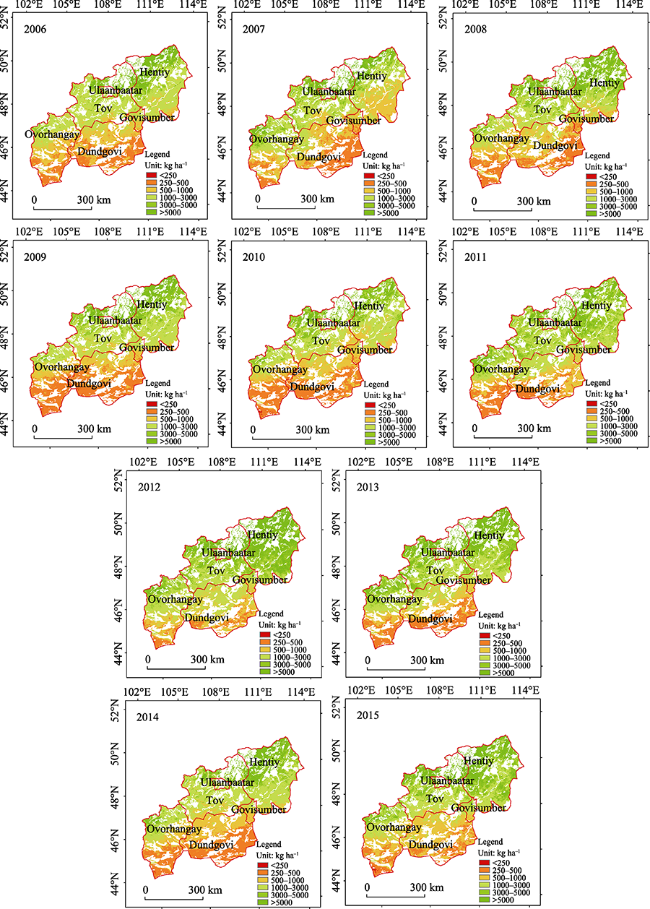
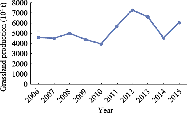
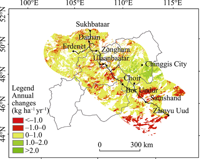
Mongolia is an important part of the Belt and Road Initiative “China-Mongolia-Russia Economic Corridor” and a region that has been severely affected by global climate change. Changes in grassland production have had a profound impact on the sustainable development of the region. Our study explored an optimal model for estimating grassland production in Mongolia and discovered its temporal and spatial distributions. Three estimation models were established using a statistical analysis method based on EVI, MSAVI, NDVI, and PsnNet from Moderate Resolution Imaging Spectroradiometer (MODIS) remote sensing data and measured data. A model evaluation and accuracy comparison showed that an exponential model based on MSAVI was the best simulation (model accuracy 78%). This was selected to estimate the grassland production in central and eastern Mongolia from 2006 to 2015. The results show that the grassland production in the study area had a significantly fluctuating trend for the decade study; a slight overall increasing trend was observed. For the first five years, the grassland production decreased slowly, whereas in the latter five years, significant fluctuations were observed. The grassland production (per unit yield) gradually increased from the southwest to northeast. In most provinces of the study area, the production was above 1000 kg ha -1, with the largest production in Hentiy, at 3944.35 kg ha -1. The grassland production (total yield) varied greatly among the provinces, with Kent showing the highest production, 2341.76×10 4 t. Results also indicate that the trend in grassland production along the China-Mongolia railway was generally consistent with that of the six provinces studied.
Key words: grassland production; MODIS; remote sensing; estimation model; Mongolia
LI Ge , WANG Juanle , WANG Yanjie , WEI Haishuo . Estimation of Grassland Production in Central and Eastern Mongolia from 2006 to 2015 via Remote Sensing[J]. Journal of Resources and Ecology, 2019 , 10(6) : 676 -684 . DOI: 10.5814/j.issn.1674-764X.2019.06.013
Table 1 Ground survey data |
| No. | Latitude (N) | Longitude (E) | Fresh weight of grass (g) |
|---|---|---|---|
| 1 | 47.9721° | 106.5823° | 56.7 |
| 2 | 47.6294° | 106.9654° | 45.0 |
| 3 | 47.4334° | 106.9728° | 75.0 |
| 4 | 47.8030° | 107.5299° | 45.0 |
| 5 | 47.6933° | 108.5277° | 41.7 |
| 6 | 47.4661° | 109.5361° | 53.3 |
| 7 | 47.2799° | 110.8333° | 123.3 |
| 8 | 47.3462° | 111.5222° | 100.0 |
| 9 | 46.3005° | 108.4715° | 33.3 |
| 10 | 46.6880° | 108.0976° | 38.3 |
| 11 | 47.7360° | 106.8914° | 48.0 |
| 12 | 47.6222° | 106.8917° | 29.3 |
| 13 | 47.3096° | 106.6711° | 32.7 |
| 14 | 46.9239° | 106.6290° | 52.7 |
| 15 | 46.5641° | 106.5309° | 27.3 |
| 16 | 46.2120° | 106.4173° | 26.7 |
| 17 | 45.8025° | 106.3062° | 10.0 |
| 18 | 45.4868° | 106.7585° | 8.7 |
| 19 | 45.1543° | 105.5664° | 7.3 |
| 20 | 44.7918° | 105.5927° | 4.0 |
| 21 | 45.4658° | 101.1738° | 15.3 |
| 22 | 45.7006° | 101.3769° | 21.3 |
| 23 | 45.8073° | 101.7643° | 59.3 |
| 24 | 45.9798° | 102.1687° | 34.0 |
| 25 | 46.1417° | 102.6169° | 38.0 |
| 26 | 46.5678° | 103.0513° | 71.3 |
| 27 | 46.8410° | 103.3977° | 21.3 |
| 28 | 47.1718° | 103.6255° | 22.0 |
| 29 | 47.5747° | 104.7149° | 37.3 |
Table 2 Correlation analysis between grassland production and impact factors |
| Element | Precipitation | Temperature | DEM | EVI | MSAVI | NDVI | PsnNet |
|---|---|---|---|---|---|---|---|
| Correlation coefficient | 0.645** | -0.477* | 0.108 | 0.762** | 0.804** | 0.798** | 0.856** |
| P value | 0.001 | 0.022 | 0.625 | 0.000 | 0.000 | 0.000 | 0.000 |
Note: * When the confidence is 0.05, the correlation is significant;** When the confidence is 0.01, the correlation is significant. |
Table 3 Grassland production estimation models based on remote sensing |
| Parameter | Model type | Inversion model | R2 | Sig. | RMSE (kg ha-1) | Accuracy (%) |
|---|---|---|---|---|---|---|
| EVI | Linear model | Y = -19.490+384.791X1 | 0.46 | 0.000 | 423.55 | 66 |
| Exponential model | Y = 4.257exp(12.647X1) | 0.63 | 0.000 | 466.53 | 63 | |
| Multivariate model | Y = -16.655+436.870X1 - 0.049X | 0.47 | 0.002 | 423.91 | 66 | |
| MSAVI | Linear model | Y = -27.370+165.323X2 | 0.57 | 0.000 | 370.00 | 71 |
| Exponential model | Y = 3.594exp(5.224X2) | 0.72 | 0.000 | 279.09 | 78 | |
| Multivariate model | Y = -18.070+239.539X2 - 0.177X | 0.61 | 0.000 | 383.40 | 70 | |
| NDVI | Linear model | Y = -13.940+204.158X3 | 0.56 | 0.000 | 335.37 | 73 |
| Exponential model | Y = 5.728exp(6.300X3) | 0.68 | 0.000 | 306.68 | 76 | |
| Multivariate model | Y = -3.192+264.166X3 - 0.119X | 0.59 | 0.000 | 308.76 | 75 | |
| MOD17A2H PsnNet | Linear model | Y = 0.482+0.403X4 | 0.68 | 0.000 | 389.21 | 69 |
| Exponential model | Y = 12.701exp(0.010X4) | 0.66 | 0.000 | 322.82 | 74 | |
| Multivariate model | Y = 16.944+0.481X4 - 0.106X | 0.70 | 0.000 | 375.42 | 70 |
| 1 |
|
| 2 |
Batunacun,
|
| 3 |
|
| 4 |
|
| 5 |
|
| 6 |
|
| 7 |
|
| 8 |
|
| 9 |
|
| 10 |
|
| 11 |
|
| 12 |
National Development and Reform Commission, Ministry of Foreign Affairs, and Ministry of Commerce of the People’s Republic of China. 2015. Vision and Actions on Jointly Building Silk Road Economic Belt and 21st-Century Maritime Silk Road. Beijing: Foreign Languages Press.
|
| 13 |
National Development and Reform Commission. Planning Outline of a China-Russia-Mongolia economic corridor.[EB/OL].( 2016- 6- 23) http://www.ndrc.gov.cn/zcfb/zcfbghwb/201609/t20160912_818326.html (in Chinese)
|
| 14 |
National Statistics Office of Mongolia. Social and Economic Situation of Mongolia[EB/OL]. ( 2018- 5- 24) http://www.en.nso.mn/index.php .
|
| 15 |
|
| 16 |
|
| 17 |
|
| 18 |
Purevgere. 2012. The Animal Husbandry Sustainable Development Research on Grassland Utilization System. MSc diss., Inner Mongolia Agricultural University. (in Chinese)
|
| 19 |
|
| 20 |
|
| 21 |
|
| 22 |
|
| 23 |
|
| 24 |
Wendurina,
|
| 25 |
|
| 26 |
|
| 27 |
|
| 28 |
|
| 29 |
|
| 30 |
|
| 31 |
|
/
| 〈 |
|
〉 |
