Resources and Environment

Estimation of Travel Climate Comfort Degree in the Cross-border Region between China and Russia based on GIS

  • ZHOU Yezhi 1, 2 ,
  • WANG Juanle , 2, 5, * ,
  • WANG Yi 3 ,
  • Elena A. Grigorieva 4
Expand
  • 1. China University of Mining and Technology (Beijing), Beijing 100083, China
  • 2. State Key Laboratory of Resources and Environmental Information System, Institute of Geographic Sciences and Natural Resources Research, Chinese Academy of Sciences, Beijing 100101, China
  • 3. National Science and Technology Infrastructure Center, Beijing 100862, China
  • 4. Institute for Complex Analysis of Regional Problems, Far-Eastern Branch, Russian Academy of Sciences, Birobidzhan 679016, Russia
  • 5. Jiangsu Center for Collaborative Innovation in Geographical Information Resource Development and Application, Nanjing 210023, China;
WANG Juanle, E-mail:

Received date: 2019-06-03

  Accepted date: 2019-07-24

  Online published: 2019-12-09

Supported by

The Strategic Priority Research Program of the Chinese Academy of Sciences(XDA2003020302)

Construction Project of China Knowledge Center for Engineering Sciences and Technology(CKCEST-2018-2-8)

Special Exchange Program of Chinese Academy of Sciences(Y9X90050Y2)

Copyright

Copyright reserved © 2019

Abstract

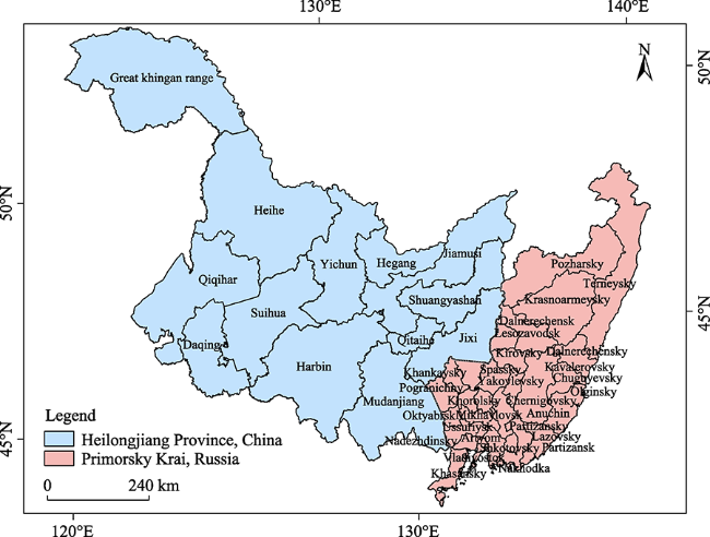
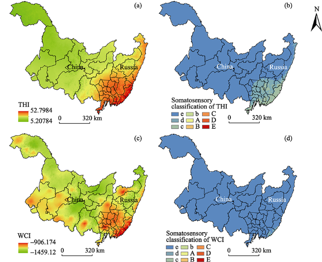
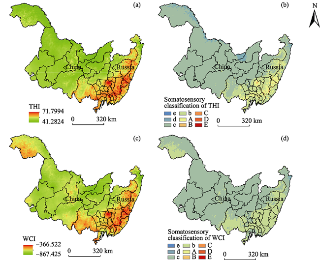
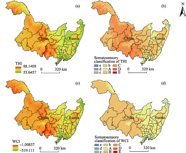
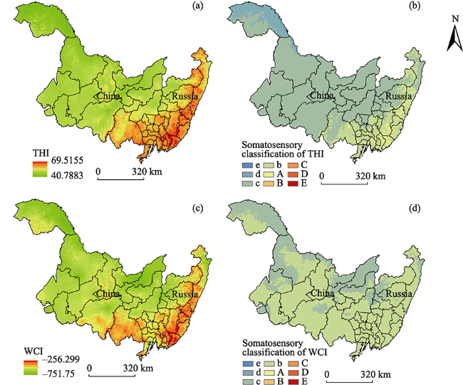
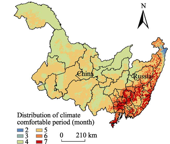
The duration of travel climate comfort degree is an important factor that influences the length of the tourism season and the development of a tourism destination. In this study, we used the monthly average meteorological data for the last 10 years from 46 weather stations in Heilongjiang Province (China) and Primorsky Krai (Russia) to calculate the temperature-humidity index (THI) and wind chill index (WCI) based on ArcGIS software interpolation technology. We obtained the climate comfort charts of the study area with a grid size a 1 km 2 grid size, and analyzed the spatial distribution of comfort for each month. The results show the following: 1) The THI and WCI of the cross-border region gradually decrease from south to north and from low altitude to high altitude. The annual comfortable climate period is longer when analyzed in terms of the WCI rather \than the THI. 2) The travel climate comfortable period of the study area shows significant regional difference and the length of the comfortable period in Heilongjiang Province is 4 to 5 months. Meanwhile, the period in Primorsky Krai decreases from south to north and the length of the comfortable period length in its southern region can reach 7 months. 3) The predominant length of the climate comfortable period in the cross-border area is 5 months per year, and it covers 46.6% of the total area, while areas that have a climate comfortable period of 2 months are the most limited, covering less than 0.3% of the area. The results provide a scientific basis for the utilization and development of a meteorological tourism resources and touring arrangements for tourists in the cross-border region between China and Russia.

Cite this article

ZHOU Yezhi , WANG Juanle , WANG Yi , Elena A. Grigorieva . Estimation of Travel Climate Comfort Degree in the Cross-border Region between China and Russia based on GIS[J]. Journal of Resources and Ecology, 2019 , 10(6) : 657 -666 . DOI: 10.5814/j.issn.1674-764X.2019.06.011

1 Introduction

Travel climate comfort degree is a bio-meteorological index used to measure the thermal comfort of the human body during travel, recreation, sightseeing, and entertainment in areas with different climate conditions from their residence according to the heat exchange theory between the human body and atmospheric environment (Sun and Li, 2015). Northeast China and the Russian Far East share a long border of more than 3000 km. As one of the most important parts of the Sino-Russia border as well as a “China-Mongolia-Russia economic corridor”, transportation and the number of people are increasing day by day. According to statistical data, 353000 Chinese citizens entered Primorsky Krai in the Far East of Russia from January to September 2018, 312000 of whom were tourists. Meanwhile, nearly half of the Russian tourists who travel to China choose to enter from the ports of Heilongjiang Province. Therefore, considering the uncontrollable influence of climate change, it is of profound relevance and applicability to provide a suitable traveling period, location selection, and corresponding risk decision to support the millions of Chinese and Russian travelers through an analysis of the thermal comfort of regional climates for travel.
Research on climate comfort assessment abroad has a history of more than 50 years (De Freitas and Grigorieva, 2015). As early as 1966, Terjung put forward the concept of climate comfort index (Terjung, 1966). In 1973, Oliver established a table of wind chill index on the basis of the bare experiment (Oliver, 1973). The Canadian Weather Bureau established the standard model of climate comfort index assessment (David, 1985). In China, the research on travel climate comfort began during the 1980s. With the in-depth development of tourism climate research, the method of research has developed from a simple qualitative description to a close combination of qualitative research and quantitative analysis and further to the use of mathematical models for evaluation research (Huang et al., 2018). The spatial patterns of Chinese thermal bioclimatic conditions from 1979 to 2014 were investigated by using ERA-Interim reanalysis data and the universal thermal climate index (Ge et al., 2017). In addition, many other scholars have begun using high-resolution data and interpolation technology to perform refined quantitative evaluations. For example, by using high-resolution grid data of climatic elements and taking the tourism climate comfort standard of Guizhou province as the zoning standard, spatial analysis and calculation of the above grid data have been carried out to obtain the spatial and temporal distributions of the thermal comfort in this region (Xiang and Yu, 2010). Based on the evaluation of travel climate comfortable degree, some studies have introduced the concept of travel climate comfortable period (TCCP) to reflect the various climatic resources that make the human body feel comfortable in a study area. This means that the sustainable time range of regional climatic comfortable resources is quantified along with its “qualitative” description (Luo et al., 2018). For example, 44 tourism hotspot cities in China were selected to calculate and evaluate their TCCP from 1971 to 2000 using monthly average meteorological data. According to the length and pattern continuity of the duration, the TCCP was divided into three kinds and two types (Liu, 2007). Ma et al. (2007) selected the monthly average meteorological data of Shaanxi Province from 1971 to 2000 and evaluated the monthly climatic comfort degree. Based on the daily meteorological data collected from the basic meteorological stations within mainland China from 1961 to 2010, the spatial pattern characteristics of the travel climate comfortable days in mainland China as well as its annual and quarterly evolution rules were studied on both national and provincial scales (Li et al., 2017).
The TCCP duration has an important impact on the choice of travel destination by travelers, which directly affects the development of tourism, commerce, and other industries in a certain region. Based on the research status and problems that have arisen, we chose three types of meteorological elements temperature, humidity, and wind speed, which are directly related to the human body and the external environment in terms of heat and moisture exchange, and used a combined evaluation model strategy to assess the travel climate comfort condition and its duration in the study area. The purpose of this study is to show the seasonal differences and evolution rule of travel climate comfort in this region and provide relevant information and decision support for passing travelers.

2 Materials and methods

2.1 General situations in the study area

In this paper, the cross-border region between China and Russia refers to Heilongjiang Province and Primorsky Krai, between 118°53′ and 139°00′E longitude and 42°00′ and 53°33′N latitude (Fig. 1). The total area of this region is 637672.2 km2. According to the Köppen-Geiger climate classification map, the study area has a hot summer continental climate characterized by large seasonal temperature differences; therefore, the region has weather conditions that vary between warm to muggy summer and chilly winter. (Kottek et al., 2006; Peel et al., 2007).

2.2 Data resource

The meteorological data used in this study include the average monthly air temperature, wind speed, and relative humidity collected from 46 meteorological stations in the study area from 2004 to 2013. The data of Heilongjiang Province were obtained from the website of China Meteorological Science Data Sharing Service (http://cdc.cma.gov.cn/) and the data of Primorsky Krai were obtained from the website of the All-Russian Research Institute of Hydrometeorological Information, World Data Center, in Obninsk (http://meteo.ru/). During the pre-processing stage, the missing values were removed and processed using the meteorological average monthly data and all the meteorological elements were unified.

2.3 Research methods

2.3.1 Selection of the evaluation model and the corresponding classification criteria
In the process of selecting the travel climate comfort evaluation model, we found that since the empirical indices such as wind chill index have advantages such as few input parameters, simple structure, and easy data accessibility, they show a considerable application prospect. Moreover, with the development of geographic information technology, which is based on the fusion of digital elevation model and multisource meteorological data, the use of empirical indices to assess climate comfort has become one of the important growing trends in this field (Yan et al., 2013; Rong et al., 2017; Jiang et al., 2018;). Based on the above considerations, we adopted the temperature humidity index (THI) and wind chill index (WCI) in the Terjung evaluation system as the main evaluation indices. The classification standards of the two corresponding indices were used to evaluate the travel climate comfort of the cross-border areas between China and Russia by using a geographic information system platform (ArcGIS) in combination with a digital elevation model (DEM) (Feng et al., 2006).
Fig. 1 Geographical location of the studied area
The THI is a bio-meteorological index proposed by Russian scientists and is determined by using a combination of temperature and humidity to estimate the heat level in the studied area. The physical significance of the model is that it improves the temperature evaluation index by taking into account the humidity (Sun and Li, 2015). The model is expressed as shown in formula below:
THI = t - 0.55(1-0.01RH)(t - 14.5)
The wind chill index (WCI) was proposed by American scientists Siple and Passel (Siple and Passel, 1945). It represents the effect of wind speed and air temperature on human heat dissipation in a cold environment and is used worldwide (Rong et al., 2017). Physically, it represents the heat dissipation per unit area of body surface at a skin temperature of 33 ℃. The model is expressed as shown in formula below:
$WCI=(33-t)(9+10.9\sqrt{v})-v$
In formulas (1) and (2), t is the air temperature (℃), RH is the relative humidity (%), and v is the wind speed (m s-1).
The regional climate comfort evaluation criteria based on the THI and WCI are shown in Table 1.
Table 1 Grade standards of THI and WCI (Zhang et al., 2014)
THI WCI Comfort
classification level
Range of value Somatosensory classification Range of value
(kcal m-2 h-1)
Somatosensory classification
<40 Extremely cold < -1000 Extremely cold wind e
40-45 Chilly -1000 - -800 Cold wind d
45-55 Cold -800 - -600 Little cold wind c
55-60 tending toward cool -600 - -300 Cool wind b
60-65 clear and cool -300 - -200 Comfort wind A
65-70 Warm -200 - -50 Warm wind B
70-75 tending toward heat -50 - 80 Skin feeling unidentified wind C
75-80 Scorching 80-160 Hot wind D
>80 Extremely Scorching >160 Skin discomfort wind E
2.3.2 Spatial interpolation of meteorological elements and data processing flow
(1) Grid of average monthly temperature data in the study area
According to the vertical variation law of temperature (Liao, 2003), the temperatures at different geographical locations are projected onto the virtual sea level (the average temperature decreases 0.65 °C for every 100 m elevation increase). The model expression is shown in formula below:
T0 = Th + 0.0065× h
In this equation, Th is the measured temperature of a certain point (℃), T0 is the measured temperature of a certain point (at the same latitude and longitude) on the virtual sea surface (℃), and h is the altitude (m) of the weather datum station.
Since the changes in air temperature at the same level are continuously considered, the inversed distance weighted (IDW) in the ArcGIS software can be used to interpolate and rasterize the air temperature values at virtual sea level. Finally, the temperature values at virtual sea level are subtracted from the temperature differences because of an elevation increase to obtain the estimated actual surface temperature values. The model expression is shown in formula 4 as follows:
TR = T′0 - 0.0065 × HDEM
In this equation, TR is the actual ground temperature value (°C); T′0 is the grid temperature at virtual sea level (°C); and HDEM is the DEM of the study area.
(2) Grid of average monthly relative humidity and wind speed
Since the relationship between relative humidity and wind speed with changing elevation is correspondingly complex, we adopted the Cokriging method to complete the grid of relative humidity and wind speed for each month. The basic approach was to consider the measured monthly average relative humidity and wind speed of the study area as dependent variables and the altitude provided in the DEM as the synergistic factor. Then, we set the parameters of the overall trend function to conduct a spatial calculation for each meteorological element.
(3) Spatial distribution production of average monthly travel climate comfort degree in the study area
According to the raster data obtained from the interpolation and the aforementioned formulas, the raster calculator of the ArcGIS software was used to substitute the formula and raster images of each meteorological element into the raster images of the THI and WCI in the study area. The images were then graded according to the evaluation criteria to obtain the spatial distribution of the monthly climatic comfort in the study area.
(4) Spatial distribution of average annual TCCP from 2004 to 2013
Combined with the classification standard of the evaluation index, it was stipulated that the climate comfort classification standards of the THI and WCI must be b, A, B, and C and then the month can be assessed as a travel climate comfortable month and the statistics used for the TCCP. Thus, the climatic comfort grade between b, A, B. and C was set to 1 and the remainder to 0. Then, the data for 12 months were summed to obtain the spatial distribution of the average annual TCCP in the study area.

3 Results and analyses

3.1 Spatial pattern of climatic comfort evaluation and travel comfort

Using the method described in section 2.3.2 and combining the spatial distributions of the average monthly air temperature, relative humidity, and wind speed at the actual surface of the study area, a spatial calculation of the average monthly travel climate comfort degree was conducted for the period from 2004 to 2013. Four typical months (1, 4, 7, and 10) were selected to reflect the distribution of the travel climate comfort degree during the four seasons of one year. The spatial distributions of the travel climate comfort for each representative month are shown in Figures 2-5:
In Fig. 2, subfigures a and b are the effect diagrams of the THI and WCI, respectively, and subfigures c and d are the grading diagrams for THI and WCI, respectively. The area can be divided on the basis of THI as follows: 1) 5.3- 40 extremely cold, extremely uncomfortable; 2) 40-45 chilly, uncomfortable; and 3) 45-52.8 cold, comparatively uncomfortable. The division based on WCI is as follows: 1) -1459.12 - -1000 very cold wind, extremely uncomfortable; and 2) -1000 - -906.2 cold wind, uncomfortable.
Fig. 2 THI, WCI, and climatic comfort in January across the studied area
In Fig. 3, subfigures a and b are the effect diagrams of the THI and WCI, respectively, and subfigures c and d are the grading diagrams of the THI and WCI, respectively. The area can be divided on the basis of THI as follows: 1) 41.3- 45 chilly, uncomfortable; 2) 45-55 cold, comparative uncomfortable; 3) 55-60 tending toward cool, comfortable; 4) 60-65 clear and cool, very comfortable; 5) 65-70 warm, comfortable; and 6) 70-71.8 tending toward hot, less comfortable. The classification of the WCI is as follows: 1) -867.4 - -800 cold wind, uncomfortable; 2) -800 - -600 light cold wind, comparatively uncomfortable; and 3) -600 - -366.5 cool wind, comfortable.
Fig. 3 THI, WCI, and climatic comfort in April across the studied area
In Fig. 4, subfigures a and b are the effect diagrams of the THI and WCI, respectively, and subfigures c and d are the grading diagrams of the THI and WCI, respectively. The area can be divided on the basis of THI as follows: 1) 55.6- 60 tending toward cool, comfortable; 2) 60-65 clear and cool, very comfortable; 3) 65-70 warm, comfortable; 4) 70- 75 tending toward hot, comfortable; 5) 75-80 scorching hot, less comfortable; and 6) 80-88.1 extremely scorching hot, uncomfortable. The division based on the WCI is as follows: 1) -519.1 - -300 cool wind, comfortable; 2) -300 - -200 comfortable wind, very comfortable; 3) -200 - -50 warm wind, comfortable; and 4) -50 - -1, skin feeling unidentified wind, less comfortable.
Fig. 4 THI, WCI, and climatic comfort in July across the studied area
In Fig. 5, subfigures a and b are the effect diagrams of the THI and WCI, respectively, and subfigures c and d are the grading diagrams of the THI and WCI, respectively. The area can be divided on the basis of THI as follows: 1) 40.8- 45 chilly, uncomfortable; 2) 45-55 cold, comparatively uncomfortable; 3) 55-60 tending towards cold, comfortable; 4) 60-65 clear and cool, very comfortable; and 5) 65-69.5 warm, comfortable. The division based on the WCI is as follows: 1) -751.75 - -600 light cold wind, less comfortable; 2) -600 - -300 cool wind, comfortable; and 3) -300 - -256.3 comfortable wind, very comfortable.
Fig. 5 THI, WCI, and climatic comfort in October across the studied area
From Figures 2 to 5, it can be seen that the overall distribution trend of THI and WCI in the study area decreases with latitude from south to north and altitude from low to high.

3.2 Analysis of travel climate comfort during seasonally representative months

In January, the study area is at the heart of winter, and most of it is extremely cold because of the northeastern monsoon. In general, the average temperature in this area during this period is between 4.4 ℃ to 35.2 ℃ the relative humidity is between 52% and 72%, and the wind speed is between 0.76 and 6.99 m s-1. According to the adopted climate comfort evaluation model, the whole area belongs to the category of somatosensory discomfort during January. The low temperature and high humidity often make the winters unbearably cold in this region, forcing many people to travel to locations at lower latitudes. However, the low temperature also creates favorable conditions for ice-snow tourism. There are numerous mountain areas around Mudanjiang and central Primorsky Krai. These resources could be used to develop ice-snow tourism and turn disadvantage into advantage.
In April, most of the study area experiences spring. In general, the average temperature of the study area is between 2.5 ℃ and 18.9 ℃, the relative humidity is between 50% and 70%, and the wind speed is between 1.77 and 5.8 m s-1 during this time. According to THI, the climate comfort condition of the Heilongjiang Province gradually improves from north to south while the climatic comfort of most parts remains cold and uncomfortable. Primorsky Krai is a climate comfort region during this except for some mountains in the north that are cold and uncomfortable are classified as at high elevations. Some areas around Spassky and Chuguevsky an extremely comfortable condition. The WEI indicates that except for most of central Heilongjiang Province and northern Primorsky Krai, the study area is climatically comfortable. Therefore, the China-Russia border area is suitable for tourism activities in April. Spring is considered the golden season for outings and flower appreciation under abundant sunshine. All tourist destinations in the region can conduct a series of tourism activities such as field outings according to their actual conditions.
In July, the Heilongjiang Province and Primorsky Krai are in the middle of summer; it is the hottest month for most of the study area Overall, the average temperature is between 13 °C to 32.9 °C, the relative humidity is between 59% and 90%, and the wind speed is between 1.11 and 5.18 m s-1. According to THI, except for the hot and uncomfortable situation in central Heilongjiang Province, the other regions are basically comfortable. In addition, the weather conditions in most regions of Primorsky Krai is warm and comfortable; only parts to the northeast remain cold. According to WCI, the whole study area is a climatic comfort zone during July. Although high temperatures and high relative humidity values are widespread in the region, it can develop mountain summer tourism in the hot summer depending on the existence of favorable conditions on the mountainous terrain, attracting visitors who come from eastern and southern China and other low latitude regions to partake in summer tourism for the favorable factors.
October is represents autumn in the study area. Generally, the average temperature is between 2.61 °C and 22.87 °C, the humidity is between 45.2% and 80%, and the wind speed is between 1.4 and 5.7 m s-1. According to the two climate comfort evaluation models, except for the northern border areas of Heilongjiang Province which are cold and uncomfortable, the areas are in a climatically comfortable and the southern part of Mudanjiang city is the most climatically suitable area for traveling. In Primorsky Krai, all regions have comfortable climate. The central and southern parts of the region and along Mount Sikhote-Alin are the most comfortable. Above all, most regions in the study area have a comfortable and pleasant climate in October. Coinciding with the National day Golden weeks in China, October has become a fabulous period for visitors from China and Russia to relax in this area.

3.3 Analysis of annual average TCCP from 2004 to 2013

According to the method described in section 2.3.2, the average annual tourism climate comfortable period of per square kilometer of the study area based on THI and WCI is shown in Fig. 6.
As shown, significant differences in TCCP occur across the cross-border area between China and Russia. The suitable tourism period gradually shortens from south to north. The area with the longest comfort period (7 months) is in the southern coastal border area where the suitable tourism period is from April to October. There is no hot suitable period for tourism in this region, only a cold one. The area with the shortest comfortable period is at the northern end of the Primorsky Krai (2 months). July and August are the best times for tourism in this region. The maximum scope for optimal tourism in the study area is 5 months across a region accounting for 46.6% of the total area. The suitable tourism periods in most of this region are during April, May, June, September, and October. However, April, May, June, August, and October are also the best months to visit the remaining areas in the study area. A tourism-suitable period of 4 months is also large, second only to the range of 5 months, the period is most concentrated in the northeastern area of Heilongjiang Province which borders Primorsky Krai; the TCCP of this region lasts from May to August. In the southern cities of the Heilongjiang Province, the TCCP also lasts for 4 months but the period is from July to October. A tourism-suitable period of 6 months is mainly distributed across the southern coastal area of the Primorsky Krai and the regions bordering The Heilongjiang Province, such as the Ussuriysk, Krasnoarmeysky, and Khorolsky districts. The climatically comfortable months are from May to October in this region.
Fig. 6 Distribution of the annual average TCCP across the study area from 2004 to 2013

4 Discussion

(1) The results show that the THI and WCI of the cross- border region gradually decrease from south to north and with an increase in altitude. The overall trend is consistent with the geographical and environmental characteristics of the region. According to the DEM, the topography of the southern part in the study area is relatively low; the southern part of the Primorsky Krai is affected by the monsoon climate of medium latitudes throughout the year, resulting in a hot and rainy seasons during spring and summer. This causes this part of the region to be favorable for relatively high travel climate comfort in the corresponding period. The northern part of the study area is surrounded by mountains and has a high altitude. In summer, this area is mainly affected by monsoon continental climate, with cool weather and moderate precipitation. These climatic characteristics make this area a summer resort. In winter, the study area is affected by the northern Siberian cold current for a prolonged time period, which leads to a dry and cold climate and a low climate comfort level for tourism (Zhang, 2015).
(2) The travel climate comfortable period of the study area shows significant regional differences. The highest value (7 months) is found in the south of Primorsky Krai along the Sea of Japan, while the lowest value (2 months) is obtained for the northeast parts of the area. The differences between China and Russia are also significant. The climate comfortable period lasts for four to five months in the Heilongjiang Province, mostly during April, May, June, September, and October. The length of the climate comfort period in Primorsky Krai increases from north to south, with the length in the southern region extending up to seven months. Based on the definition of travel climate comfort period in this paper, there are no months suitable for tourism activities in the study area during winter. These results are similar to those observed by some other scholars in recent years. For example, Li et al. (2009) found that there are numerous climate comfortable days in the Heilongjiang Province during spring and summer, with least number of days in winter, via analyzing the annual change characteristics of human body thermal comfort and its spatial patterns in each season. Generally, a trend of less climate comfortable days in the north and more days in the south is observed, and the number of days varies greatly among cities.
(3) The paper assessed the travel climate comfort conditions of the cross-border region based on the assembled climate comfort evaluation model of THI and WCI. The mode of using the combined model for climate comfort assessment of a certain region has been widely used in previous studies. For example, the spatial distribution and timing characteristics of synthetic climate comfort condition in the coastal area of the Shandong Province were analyzed by calculating the corresponding climate comfort evaluation model (Zhang et al., 2014); Liu et al. (2013) used THI and WCI to establish a comprehensive evaluation model of desert tourism climate comfort, and the monthly climate comfort index of 29 desert tourism potential areas in China was calculated. It follows that using combined evaluation model strategy can not only be applicable to any space-time scale, but can also evaluate the climate comfort condition in different types of travel sites as well.
(4) Some limitations exist as to the methods and potential applications of this study. Regarding the methods, the main influencing factors of climate comfort selected in this study include air temperature, relative humidity, and wind speed. However, other than these, many other climatic factors (such as sudden catastrophic weather factors) affect human
climate comfort (Belen and Martin, 2005). Therefore, for furthering this study, we need to identify and analyze the common extreme climate disaster risks which frequently occur in the study area, and optimize the travel paths incorporating the factors influencing travel climate comfort period and natural disaster risks. In terms of the application of the obtained results, the tourism divisions of each city in the study area can be considered. The construction of these divisions will not only make use of the tourism climate comfort condition generated in this study, but also include the data from various sources in the field of regional ecological environment as well as socio-economic development. These divisions will provide guidance to the travelers in terms of more accurate travelling options and route planning (Yu et al., 2014; Rong et al., 2017; Jiang et al., 2018).

5 Conclusions

The present study was aimed to carry out the assessment of travel climate comfort level in the cross-border region and reflect its characteristics and differences through comparison between China and Russia. The THI and WCI of the study area were calculated using three meteorological data of the study area from 2004 to 2013: temperature, relative humidity, and wind speed. The ArcGIS platform was used to obtain the travel climate comfort evaluation map to analyze and describe the spatial and temporal distribution and trends of the climate comfort conditions. The results show that the overall distribution of the THI and WCI in the China-Russia border area decreases from south to north latitudinally, and with an increase in altitude. The climate comfortable zone based on the WCI is larger than that based on the THI. The predominant length of the climate comfortable period in the cross-border area is five months per year which covers approximately 46.6% of the total area, while areas that have a climate comfortable period for two months are the most limited, covering less than 0.3% of the area. The research is expected to provide the scientific basis and theoretical reference for the utilization and development of meteorological tourism resource in the transboundary area of China and Russia.
1
Belen M, Martin G . 2005. Weather, climate and tourism a geographical perspective. Annals of Tourism Research, 32(3):571-591.

DOI

2
David D H . 1985. Handbook of Applied Meteorology. New York: John Wiley&Sons Inc., 778-811.

3
De Freitas C R, Grigorieva E A . 2015. A comprehensive catalogue and classification of human thermal climate indices. International Journal of Biometeorology, 59:109-120.

DOI PMID

4
Feng X L, Chen Z Z, Lu L C . 2006. The summary of Terjung method for calculating the comfortable climate of Chinese tourism. Ecological Economy, ( 8):67-69. (in Chinese)

5
Ge Q, Kong Q, Xi J , et al. 2017. Application of UTCI in China from tourism perspective. Theoretical and Applied Climatology, 128:551-561.

DOI

6
Huang J, Li L, Tan C , et al. 2018. Mapping summer tourism climate resources in China. Theoretical and Applied Climatology, 137:2289-2302.

DOI PMID

7
Jiang H, Yang Y, Bai Y . 2018. Evaluation of all-for-one tourism in mountain areas using multi-source data. Sustainability, 10:4065.

DOI

8
Kong Q, Zheng J, Fowler H J , et al. 2018. Climate change and summer thermal comfort in China. Theoretical and Applied Climatology, 137(1-2):1077-1088.

DOI PMID

9
Kottek M, Grieser J, Beck C , et al. 2006. World Map of the Köppen-Geiger climate classification updated. Meteorologische Zeitschrift, 15(3):259-263.

DOI

10
Li S, Sun M, Zhang W , et al. 2017. Climate Comfortable Period in Mainland of China (1961-2010) [DB/OL]. Global Change Research Data Publishing & Repository..

11
Li Y B, Wang X M, Li C C . 2009. Preliminary analysis of human comfort climate index in Heilongjiang Province. Heilongjiang Meteorology, 26(2):22-24. (in Chinese)

12
Liao S B, Li Z H, You S C . 2003. Comparition on methods on rasterization of air temperature data. Resources Science, 25(6):83-88. (in Chinese)

13
Liu H Y, Wu Y, Wang N A , et al. 2013. Analysis of climate comfort conditions in the desert tourism zone in China. Resources Science, 35(4):1-3. (in Chinese)

14
Liu Q C, Wang Z, Xu S . 2007. Climate suitability index for city tourism in China. Resources Science, 29(1):133-141. (in Chinese)

15
Luo Y . 2018. Climate comfort region in Chinese Mainland: Its seasonal fluctuation and type pattern. MSc diss., Shanghai: East China Normal University. (in Chinese)

16
Ma L J, Sun G N, Li F L , et al. 2007. Evaluation of tourism climate comfortableness in Shaanxi Province. Resources Science, 29(6):40-44. (in Chinese)

17
Oliver J E . 1973. Climate and Man’s Environment: An Introduction to Applied Climatology. New York: John Wiley &Sons Inc.: 195-206.

18
Peel M C, Finlayson B L, McMahon T A . 2007. Updated world map of the Köppen-Geiger climate classification. Hydrology and Earth System Sciences, 11:1633-1644.

DOI

19
Rong Y L, Zhang X, He Q . 2017. Study and analysis of meteorological effect on Shanghai Sheshan National Tourist Resorts in Shanghai. Journal of Geoscience and Environment Protection, 5:11-22.

20
Siple P A, Passel C F . 1945. Measurements of dry atmospheric cooling in sub-freezing temperatures. Proceedings of the American Philosophical Society, 89:177-199.

DOI PMID

21
Sun M S, Li S . 2015. Empirical indices evaluating climate comfortableness: Review and prospect. Tourism Tribune, 30(12):19-34. (in Chinese)

DOI

22
Terjung W H . 1966. Physiologic climates of the contentious United States: A bioclimatic classification based on man. Annals of the Association of American Geographers, 5(1):141-179.

23
Xiang H Q, Yu F . 2010. High-resolution temporal and spatial distribution of tourism meteorological comfort level in Guizhou mountainous area. Journal of Guizhou Meteorology, 34(8):3-6. (in Chinese)

24
Yan Y C, Yue S P, Liu X H , et al. 2013. Advances in assessment of bioclimatic comfort conditions at home and abroad. Advances in Earth Science, 28(10):1119-1125. (in Chinese)

DOI

25
Yu Z K, Sun G N, Feng Q . 2014. Tourism climate comfort and risk for the Qinghai-Tibet Plateau. Resources Science, 36(11):2327-2336. (in Chinese)

PMID

26
Zhang X M, Yang Q J, He Z M . 2014. Analysis and division of travel climate comfort level in Shandong. Science of Surveying and Mapping, 39(8):140-147. (in Chinese)

27
Zhang L C . 2015. The Analysis and Evaluation of Microclimate for Rural in Northeast Cold Region. MSc diss., Harbin: Harbin Institute of Technology. (in Chinese)

Outlines

/