Human Activities and Ecosystem

Delimitation of Urban Growth Boundary Based on the Coordination of Ecology and Residential Activity Spaces: A Case Study of Jinan, China

  • JIA Kun 1, 2 ,
  • ZHANG Chao 1, 2 ,
  • YANG Yanzhao , 1, 2, 3, * ,
  • YOU Zhen 1
Expand
  • 1.Institute of Geographic Sciences and Natural Resources Research, Chinese Academy of Sciences, Beijing 100101, China
  • 2.University of Chinese Academy of Sciences, Beijing 100049, China
  • 3.Key Laboratory of Carrying Capacity Assessment for Resource and Environment, MNR, Beijing 101149, China
* YANG Yanzhao, E-mail:

Received date: 2019-02-21

  Accepted date: 2019-05-16

  Online published: 2019-10-11

Supported by

National Natural Science Foundation of China(41430861)

Copyright

Copyright reserved © 2019

Abstract

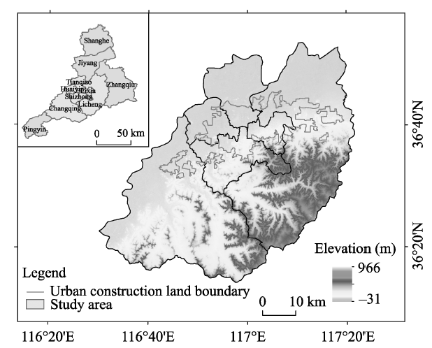
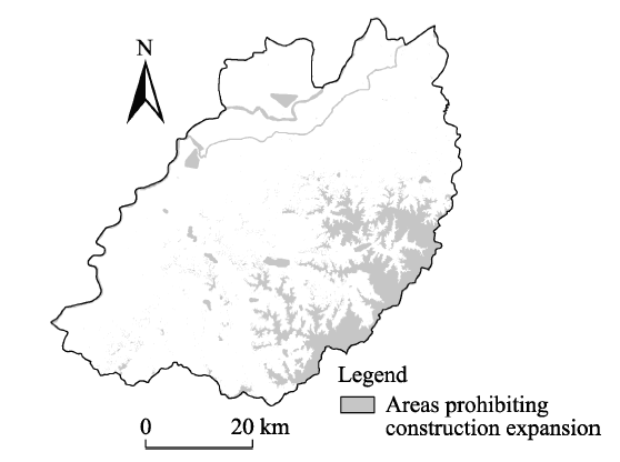
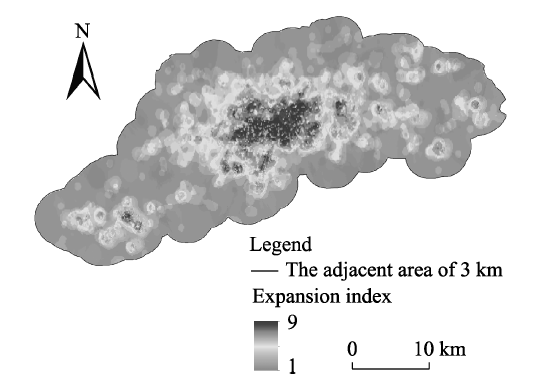
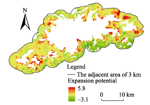
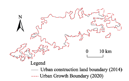
Delimitation of an urban growth boundary (UGB) can effectively curb disorderly urban expansion, optimize urban development space and protect the ecological environment. Eco-environmental sensitivity was evaluated and areas prohibiting construction expansion were extracted by establishing an index system. Point of interest (POI) and microblog data were utilized to analyze the expansion of residential activity space. Urban space expansion potential was calculated using a comprehensive evaluation model, and an urban growth boundary for Jinan in 2020 was delimited combining the predicted urban expansion scale. The results showed that: (1) An evaluation of eco-environmental sensitivity can effectively protect ecological land and provide an ecological basis for urban expansion. Regions with high eco-environmental sensitivities in Jinan are located along the banks of the Yellow River and Xiaoqing River and in southeast mountainous areas, but eco-environmental sensitivities in the central, north and southeast areas are relatively low; (2) The model to evaluate urban residential activity expansion can quantify the spatial distribution of urban residents' activities. Regions with high potential for residential activity space expansion in Jinan are mainly concentrated in the middle of Jinan and most are part of existing built-up areas and surrounding areas; (3) The method that delimits urban growth boundaries based on the coordination of ecology and residential activity space is reasonable. Spatial expansion in Jinan mainly extends towards the east and west wings, and the boundary conforms to the spatial strategy guiding Jinan’s development and is consistent with the overall layout in related plans. Considering both ecological protection and the internal forces driving urban expansion, the method of urban growth boundary delimitation used in this study can provide a reference and practical help for studies and management of urban development in the new era.

Cite this article

JIA Kun , ZHANG Chao , YANG Yanzhao , YOU Zhen . Delimitation of Urban Growth Boundary Based on the Coordination of Ecology and Residential Activity Spaces: A Case Study of Jinan, China[J]. Journal of Resources and Ecology, 2019 , 10(5) : 518 -524 . DOI: 10.5814/j.issn.1674-764X.2019.05.007

1 Introduction

Land is the spatial carrier and support for urban development that leads to urban land expansion and changes of the urban spatial structure. During the expansion process, some cities blindly pursue growth in scale while neglecting digging the urban potential, which results in a disorderly extension of urban land. In addition, an increase in the amount of urban land is usually accompanied by encroachment on superior farmland and important ecological lands, a decrease of cultivated land and a series of eco-environmental problems. Delimitation of an urban growth boundary contributes to reducing the speed of urban land growth from a macro scale, limiting tension with respect to land resources, reversing the lack of a matchup between land urbanization and population urbanization, optimizing urban development space, and improving urban land utilization efficiency.
An urban growth boundary was first proposed and applied in Salem, Oregon, in the United States. It represented a recognition and reflection upon urban spatial development patterns and development quality (Jun, 2006). Although there is not a single understanding of the meaning of urban growth boundary among scholars, all of the existing concepts are of uniform in their connotations and fundamental objectives. Spatial regulation is applied in order to prevent disorderly urban expansion, improve the level of land use intensity in the city area, and protect urban natural resources and the ecological environment.
At present, the delimitation of urban growth boundaries is a research hotspot among scholars (Sinclair, 2014). Many scholars have adopted a multi-factor comprehensive evaluation method with an emphasis on land property and protection of the regional ecological environment (Zhou et al., 2007; Wang et al., 2012; Wu et al., 2015). In regions where data are lacking, remote sensing methods are usually used to analyze urban land use so as to delimit UGBs (Brown et al., 2007). Zhu et al. (2009) analyzed the ecological sensitivity of the land so as to delimit a rigid boundary and an elastic boundary of urban growth. He et al. (2010) used a GIS technique to evaluate construction land suitability based on delimitation of areas prohibiting construction expansion, and then delimited expansion boundaries for construction land from bottom to top by predicting the expansion scale. Another method which has been used extensively is model-based urban development simulation. The city is regarded as a continuously growing organic entity. An artificial neural network (Tayyebi et al., 2011; Fu et al., 2016) or a cellular automaton (Liu, 2009; Long et al., 2009; Li, 2011; Su et al., 2012; Long et al., 2013) method is often used to establish corresponding models to delimit UGBs. Based on a full consideration of the self-organized operational trajectory of the urban system, Tayyebi et al. (2011) integrated techniques such as remote sensing, geographical information systems and artificial neural networks to establish a model built around multiple factors such as roads, slopes and green land. The model was used to delimit a UGB, taking Teheran, Iran, as an example. Zhang et al. (2013) used an urban space orientation method to investigate the delimitation of an urban growth boundary in Hangzhou. Some studies have used spatial heterogeneity research theory to divide the study area into different small areas, establish a pertinent algorithm based on decision-making trees and finally delimit a UGB (Triantakonstantis et al., 2011). Ma et al. (2017) developed an ant colony optimization algorithm by incorporating dynamic processes and planning interventions to delimit UGBs.
Recently, studies focused on the use of big data to understand urban development have emerged (Hashem et al., 2016; Osman, 2019). Big data has been used to explore the relationship between urban growth patterns and urban vitality in order to provide guidance on urban spatial development (He et al., 2018). Utilization of big data can help regulate urban expansion and improve urban resource management (Zeng et al., 2017). Combining traditional data with big data to identify time and space properties provides new ideas for the study of urban expansion and promotes making the delimitation of UGBs more refined, accurate and scientific. In this study of Jinan, full consideration was given to factors limiting urban land expansion, and areas prohibiting construction expansion were extracted based on an eco-environmental sensitivity evaluation, and then POI and Microblog data were combined to analyze the expansion of space for residential activity. Urban expansion potential was calculated based on the coordination of ecology and residential activity space, and GIS spatial analysis technology was used to comprehensively delimit an urban growth boundary.

2 Materials and methods

2.1 Study area

Located in the middle of Shandong Province, Jinan is the provincial capital. Land in the south of Jinan is at high elevations and land in the north at low elevations; the Yellow River flows through the north of Jinan. The middle area of Jinan is a piedmont plain belt and it is close to Mount Tai; the south is hilly and mountainous. Due to its distinct terrain and geological structure, Jinan has numerous springs with unique characteristics, and these should be specially protected during the urban development process. Jinan is located in the Cirum-Bohai Sea Economic Area and at the intersection of the important Beijing-Shanghai economic axis. Moreover, it is a core city in the urban agglomeration of the Shandong peninsula with rapid urban development and continuously expanding construction land. The urbanization rate in Jinan in 2015 reached 57.01%, and the area of construction land was 392 km2. While the urban development is occurring rapidly, resource and environmental pressure in Jinan is increasingly aggravated.

2.2 Datasets

The areas included in this study are Lixia District, Shizhong District, Huaiyin District, Tianqiao District, Licheng District and Changqing District in Jinan (Fig. 1). Landsat 8 OLI remote sensing images and Digital Elevation Model (DEM) for Jinan in 2014 were both derived from the geographical spatial data cloud (http://www.gscloud.cn/). Fundamental statistical data were taken from the Shandong Statistical Yearbook compiled by the Shandong Statistics Bureau. POI and Sina microblog data for Jinan were taken from Baidu map and the official website of the Sina microblog (December, 2016). The scope of the existing built-up areas in Jinan were interpreted and extracted based on remote sensing images. The acquired POI data included middle and primary schools, colleges and universities, large-scale medical treatment and public health facilities, large banks, hypermarkets and shopping malls, movie theaters and parks in the study area. Sina microblog data included user names, microblog sign-in times, longitude and latitude coordinates and microblog text content. Spatial resolution in the related calculation was 30 m ´ 30 m.

2.3 Methods

Delimitation of an urban growth boundary firstly needs to consider urban natural environmental features. Related indexes were selected first in this paper to conduct an eco-environmental sensitivity evaluation and extract areas to prohibit construction expansion as ecological safety baselines for urban expansion. Socio-economic factors and human behaviors are the internal driving forces of urban expansion. Therefore, POI data and microblog data were integrated in this paper to analyze urban infrastructure configuration, spaces for residential social activities and social perception features so as to quantify the probability of residential activity space expansion. Urban expansion potential was finally calculated based on the coordination of the ecological environment and residential activity space, and an urban expansion forecasting model was combined to delimit an urban growth boundary.
2.3.1 Eco-environmental sensitivity evaluation and extraction of areas to prohibit construction expansion
In consideration of the principal natural conditions of urban construction land expansion and eco-environmental limiting factors, and starting from the perspective of eco-environmental protection and sustainable development, an evaluation index system was established based on three first grade indexes―topographic conditions, water sources and bio- inhabitation sensitivity. The actual index system and grading standards are shown in Table 1. It is noteworthy that bio-inhabitation sensitivity is usually evaluated based on species richness in the ecological environment, but it is difficult to realize its spatial quantification. Aboveground vegetations on which species depend were used in this paper for analysis. The normalized differential vegetation index (NDVI) was used to reflect natural state maintenance degree and vegetation growth in the ecological environment. Regions with a high NDVI index are also regions with high ecological value needing key conservation, and their eco-environmental sensitivity is also high (Liu et al., 2015).
Table 1 Classification standards of eco-environmental sensitivity in Jinan
Factors Insensitive Light sensitive Moderate sensitive Highly sensitive Extreme sensitive
Topographic Elevation (m) ≤100 100-150 150-200 200-400 ﹥400
Slope (°) ≤5 5-15 15-25 25-35 ﹥35
Water Distance from river (m) ﹥1000 500-1000 200-500 100-200 0-100
Distance from lakes and reservoirs (m) ﹥2000 1000-2000 500-1000 200-500 0-200
Bio-inhabitation NDVI 0-0.2 0.2-0.4 0.4-0.6 0.6-0.7 0.7-1
Value 1 3 5 7 9
The index system for the comprehensive evaluation of eco-environmental sensitivity is a system consisting of multiple factors such as terrain, water sources and habitats, and the commonly used calculation methods are a weight-based weighing calculation method and an index calculation method. As it is difficult to determine contribution rates of various factors in the study area, the formula for the index calculation method is used in this paper as follows:
. $ES=\sqrt[n]{\prod\limits_{i=1}^{n}{Ci}}$
where ES is the comprehensive sensitivity index for the ecological environment; Ci is the sensitivity grade value of factor i; and n is the number of factors.
The area prohibiting construction expansion has rigid boundaries and an ecological safety baseline for urban expansion (Wang et al., 2015), so it should be strictly protected, and all urban construction activities are prohibited in the area in principle. Delimitation of areas prohibiting construction expansion in this paper is as such: extreme sensitivity areas of each factors are extracted for spatial superposition, and the finally formed scope is namely the area prohibiting construction expansion.
2.3.2 Urban expansion scale forecasting and delimitation of adjacent areas
Urban expansion is a gradual outward expansion processbased on existing built-up areas. Before an urban growth boundary is determined, the anticipated growth of urban construction land growth within a certain future time period should be estimated. This paper adopts a scenario analysis method that simulates several future construction land expansion scenarios based on urban development status and tendency (He et al., 2010). Construction land area and its added value at a point of time in the future are determined based on the area of existing construction land. Although this method is strongly subjective, it can artificially control total urban land expansion.
In consideration of the continuity and integrity of urban expansion, urban expansion during a certain time period is determined within a certain scope outside the existing built-up area. Therefore, based on the urban expansion forecasting scale, the adjacent area is built on up to a certain distance based on the existing built-up area.
2.3.3 Analysis of the expansion of space for residential activity based on POI and microblog data
Humankind is the subject of urban activities, and social behaviors of human beings can influence the speed and direction of urban expansion and urban spatial structure in important ways that affect urban development. Expansions of space for residential activities usually select those areas with favorable urban development bases that have relatively complete infrastructure and are safe. These areas can be more easily transformed into construction land within a certain period of time.
POI data involves various fields of socio-economic development and can be regarded as a comprehensive representation of a given socio-economic development situation. It can be used to characterize intentions with respect to expansions of spaces for residential activities. POI data was used in this paper to reflect spatial differences in aspects of regional development status and infrastructure configuration. The greater the kernel density of POI data, the higher the level of socio-economic development in that area and the more complete the infrastructure, indicating a higher intention to expand the space for residential activity in the area. The spatial density of microblog sign-in data can indicate the distribution of regional residential activity space to some extent. The greater the kernel density of the microblog, the more aggregated the regional residential activities, and the more suitable the area is for urban expansion. This paper used emotional analysis software to conduct semantic analysis of each microblog text so as to judge the emotional attitude of the microblog publisher. The better the emotional attitude value, the stronger the sense of happiness the resident has for this area, the higher the sense of safety, and the less likely that criminal activities or violence will occur, making the area suitable for urban expansion.
Therefore, an evaluation index system for expansion of space for residential activity is established based on POI and microblog data. Details of the index system and the grading standards are shown in Table 2. The index calculation method is used to calculate a comprehensive index for expansion of residential activity space based on POI and microblog data, and the formula is as follows:
$RS=\sqrt[n]{\prod\limits_{i=1}^{n}{Ki}}$
Table 2 Classification and grading standards for expansion of residential activity space in Jinan based on POI and microblog data
Indicators
POI Kernel density 0-6000 6000-30000 30000-80000 80000-160000 ﹥160000
Microblog Kernel density 0-20000 20000-200000 200000-500000 500000-1600000 ﹥1600000
Emotional attitude < -15 -15 - -1 -1-1 1-10 >10
Value 1 3 5 7 9

where RS is the residential activity space expansion index; Ki is expansion grade value of factor I; and n is the number of factors.

2.3.4 Calculation of potential for urban spatial expansion and delimitation of urban growth boundary
Existing construction land area and areas that prohibit construction expansion are excluded. Urban spatial expansion potential is calculated keeping in mind the need to have a low eco-environmental sensitivity value in the region and a high residential activity space expansion index. Based on the principle of balance between land supply and demand, spatial land distribution is implemented according to urban spatial expansion potential based on the urban expansion forecasting model so as to delimit an UGB. The calculation formula for urban spatial expansion potential is as follows:
$P(x,y)=RS(x,y)-ES(x,y)$
where P(x, y) is urban spatial expansion potential of this land unit; RS(x, y) is residential activity space expansion index of this land unit; and ES(x, y) is the comprehensive eco-environmental sensitivity index of this unit.

3 Results

3.1 Eco-environmental sensitivity evaluation and extraction of areas prohibiting construction expansion

Fig. 2 shows the comprehensive evaluation results of eco- environmental sensitivity in Jinan. Fig. 3 shows areas prohibiting construction expansion in Jinan, extracted based on the evaluation results of eco-environmental sensitivity.

Fig. 2 Spatial distribution of eco-environmental sensitivity in Jinan

Fig. 3 Areas prohibiting construction expansion in Jinan

According to Fig. 2 and Fig. 3, areas with high eco-environmental sensitivity values in Jinan are located along the banks of the Yellow and Xiaoqing rivers, and in the southeastern mountainous area. Areas prohibiting construction expansion are also distributed mainly in these areas, while eco-environmental sensitivity values in the central, northern and southwestern parts of Jinan are relatively low.
Future urban expansion needs to be strictly regulated and urban development controlled in the southern mountainous area and the northern Yellow River protected area. The ecological agriculture and tourism can be appropriately developed. Eco-environmental sensitivity is not high on the central plain, and this should be taken as the center point for urban development to form a spatial transverse development axis. Urban land use intensity should be actively improved so as to realize urban aggregation and highly efficient development.

3.2 Urban expansion scale forecasting and residential activity space expansion analysis

The area of existing construction land in Jinan in 2014 was 383 km2. According to relevant studies (He et al., 2010; Zhu and Wang, 2011) and taking into consideration the development status and features of Jinan, construction land in Jinan is expected to increase by 58 km2 (15% increasing scenario) with the total area of construction land reaching 441 km2 in 2020. In consideration of this expansion scale, the scope of adjacent areas of Jinan is set as 3 km in this paper.
The expected expansion of space for residential activity based on POI and microblog data is shown in Fig. 4. Areas with high residential activity space expansion values have favorable overall economic conditions, relatively complete infrastructure and more positive emotions from urban residents. Priority should be given to urban spatial expansion in these areas. Fig. 4 shows that areas with high residential activity space expansion values are distributed mainly in central Jinan, and other existing built-up areas and surrounding areas. Areas with low urban residential activity space expansion values are mainly distributed at the southern and northern sides of Jinan and edge zone of the adjacent areas.

Fig. 4 Index of residential activity space expansion based on POI and microblog data in Jinan

3.3 Analysis of potential for urban spatial expansion and delimitation of an urban growth boundary

According to the analysis of the potential for urban spatial expansion in Jinan (Fig. 5), areas with high potential for spatial expansion are distributed mainly at the fringes of existing urban spaces. The potential for expansion in southern areas of Jinan is generally low, but it is high in eastern and southwestern areas. Based on an estimate of the urban growth scale for Jinan in 2020, an urban growth boundary was delimited based on the potential for urban spatial expansion. Priority was given to closed grouped areas within larger areas, and the area threshold method was used to exclude random patches of small areas. On this basis, an UGB for Jinan in 2020 was generated (Fig. 6).

Fig. 5 Potential for urban spatial expansion in Jinan

Fig. 6 Delimitation of urban growth boundary for Jinan in 2020

The delimited UGB for 2020 bases expansion on existing built-up areas and takes the east and west wings as the main directions for expansion. This is in accordance with Jinan’s urban spatial development strategy of “exploit eastward, forge westward, control the south, cross the north and disperse the center.” It is also consistent with the three-belt spatial development pattern proposed in the urban master plan (2006-2020) for Jinan.

4 Conclusions and discussion

In recent years, many cities have pursued a “metropolis” development strategy and blindly expanded towards surrounding areas. This has not only resulted in the extensive utilization or waste of much land in interior urban spaces, it has also intruded on farmland and damaged the ecological environment. Delimitation of UGBs can not only guide reasonable urban expansion and improve land utilization efficiency, but also protect resources and the environment. After taking into consideration factors that limit urban development, traditional data were combined with POI and microblog data in this paper. Based on an evaluation of eco-environmental sensitivity and an analysis of residential activity space expansion, the potential for urban expansion was comprehensively determined and then an urban growth boundary for Jinan was delimited based on the total scale of urban expansion. This paper’s main conclusions are as follows:
This study evaluated the sensitivity of urban ecological environment and extracted areas that prohibit construction expansion, as these steps can effectively protect ecological land and provide an ecological basis for urban expansion. Areas with high ecological environmental sensitivity values in Jinan are located along the banks of the Yellow and Xiaoqing rivers and in the southeastern mountainous area. A model based on POI and microblog data to evaluate the expansion of urban residential activity spaces can quantify the spatial distribution of urban residents’ activities, and identify the internal driving forces of urban expansion. Areas with high values for the expansion of residential activity space are mainly distributed in the middle of Jinan, and most are in existing built-up areas and surrounding areas. Delimiting an urban growth boundary delimitation based on the coordination of ecology and residential activity space is reasonable. The boundary of Jinan accords with spatial strategies of urban development and is consistent with the overall layout of the city put forward in related municipal plans. Urban expansion in Jinan mainly extends towards east and west wings along the traffic corridor.
New big data sources like POI and microblogs were combined with traditional data sources and utilized in this paper. This study takes into consideration both urban expansion and ecological protection and can serve as a reference for researchers focused on urban expansion in the new era. Generally, evaluations of urban expansion potential are objective, but the final delimitation of an urban growth boundary can be highly subjective in terms of its practical application. The boundary gives decision makers a certain level of flexibility. Rigidly accepting the potential for urban expansion presented in this study is not necessary; factors like policy decisions that influence urban expansion can be taken into consideration. The method proposed in this study for UGB delimitation based on the coordination of ecology and residential activity space can be applied to other cities. However, because each city has unique characteristics in terms of its urban development pattern, land use structure and ecological land resources, it is necessary to select appropriate index systems and determine the corresponding classification and grading standards in accordance with the unique characteristics of the locale. In this way the accuracy and scientific soundness of UGB delimitation can be guaranteed (Zhu and Wang, 2011). Inconsistent evaluation standards limit the reliability of research results, and make it difficult to carry out comparative research among different cities. Furthermore, as the understanding of urban big data increases, it will become increasingly useful to combine greater quantities and more types of big data to provide guidance for urban development in the future.
[1]
Brown D G, Robinson D T, An L , et al. 2007. Exurbia from the bottom-up: modeling multiple actors and their landscape interactions. Geoforum, 39:805-818.

[2]
Fu L, Hu Y C, Zheng X Q . 2016. The prediction of urban growth boundary based on BP artificial neural networks: An application to Beijing. China Land Science, 30(2):22-30. (in Chinese)

[3]
Hashem I A T, Chang V, Anuar N B , et al. 2016. The role of big data in smart city. International Journal of Information Management, 36(5):748-758.

[4]
He C Y, Jia K J, Xu X L , et al. 2010. Planning method for defining the boundary of the urban and rural construction land expansion based on spatial analysis technology of GIS. China Land Science, 24(3):12-18. (in Chinese)

[5]
He Q S, He W S, Song Y , et al. 2018. The impact of urban growth patterns on urban vitality in newly built-up areas based on an association rules analysis using geographical ‘big data’. Land Use Policy, 78:726-738.

[6]
Jun M J . 2006. The effects of Portland’s urban growth boundary on housing prices. Journal of the American Planning Association, 72(2):239-243.

[7]
Li Y H . 2011. Method of determining urban growth boundary from the view of ecology: A case study of Hangzhou. City Planning Review, 35(12):83-90. (in Chinese)

[8]
Liu J H, Gao Z X, Ma S , et al. 2015. Comprehensive evaluation of eco-environmental sensitivity in Inner Mongolia, China. China Environmental Science, 35(2):591-598. (in Chinese)

[9]
Liu Y . 2009. Using SLEUTH model to simulate and assess future scenarios of urban expansion. Economic Geography, 29(10):1661-1664. (in Chinese)

[10]
Long Y, Han H Y, Mao Q Z . 2009. Establishing urban growth boundaries using constrained CA. Acta Geographica Sinica, 64(8):999-1008. (in Chinese)

[11]
Long Y, Han H, Lai S K , et al. 2013. Urban growth boundaries of the Beijing Metropolitan Area: Comparison of simulation and artwork. Cities, 31(2):337-348.

[12]
Ma S F, Li X, Cai Y M . 2017. Delimiting the urban growth boundaries with a modified ant colony optimization model. Computers, Environment and Urban Systems, 62:146-155.

[13]
Osman A M S . 2019. A novel big data analytics framework for smart cities. Future Generation Computer Systems, 91:620-633.

[14]
Sinclair S K . 2014. Methods and considerations for determining urban growth boundaries - An evaluation of the Cape Town experience. Urban Forum, 25(3):313-333.

[15]
Su W Z, Yang G S, Chen S , et al. 2012. Analysis method of urban growth boundary of the Changzhou City in the Yangtze River delta. Journal of Natural Resources, 27(2):322-331. (in Chinese)

[16]
Tayyebi A, Pijanowski B C, Tayyebi A H . 2011. An urban growth boundary model using neural networks, GIS and radial parameterization: An application to Tehran, Iran. Landscape and Urban Planning, 30:35-44.

[17]
Triantakonstantis D, Mountrakis G, Wang J D . 2011. A spatially heterogeneous expert based (SHEB) urban growth model using model regionalization. Journal of Geographic Information System, 3:195-210.

[18]
Wang Y, Gu C L, Li X J . 2015. Preliminary study on urban growth boundary of Suzhou City. Journal of Urban and Regional Planning, 8(2):1-24. (in Chinese)

[19]
Wang Y G, Yin X L, Li G C . 2012. Delimitation of urban growth boundary based on land ecological suitability evaluation: A case of Shenshan Special Corporation Zone. Urban Development Studies, 19(11):76-82. (in Chinese)

[20]
Wu X P, Chen Z J, Jia C Y , et al. 2015. Urban growth boundary of county level towns: Baisha Li Ethnic Minority County. Planners, 31(9):126-132. (in Chinese)

[21]
Zeng C, Yang L D, Dong J N . 2017. Management of urban land expansion in China through intensity assessment: A big data perspective. Journal of Cleaner Production, 153(1):637-647.

[22]
Zhang Z G, Zhang S W . 2013. The ideas and methods of spatial structure-oriented urban growth boundary delimitation - A case study of Hangzhou City. Urban Planning Forum, 57(4):33-41. (in Chinese)

[23]
Zhou J F, Zeng G M, Huang G H , et al. 2007. The ecological suitability evaluation on urban expansion land based on uncertainties. Acta Ecologica Sinica, 27(2):774-783. (in Chinese)

[24]
Zhu X X, Wang H M . 2011. Research methods of expansion scale of urban construction land based on GIS: A case of Fogang County in Guangdong. Economic Geography, 31(4):660-665. (in Chinese)

[25]
Zhu Z W, Mo B, Xie F R . 2009. Delimitation of urban growth boundary based on land ecological suitability evaluation: A case of Fangchenggang. Planners, 25(11):40-44. (in Chinese)

Outlines

/