Human Activities and Ecosystem

Different Irrigation Methods and Their Comparisons Based on the Parametric Evaluation Method in Khosouyeh Dam Subbasin, Iran

  • Masoud MASOUDI , * ,
  • Reza ZARE
Expand
  • Department of Natural Resources and Environmental Engineering, College of Agriculture, Shiraz University, Shiraz 7144165186, Iran
* Masoud MASOUDI, E-mail:

Received date: 2018-11-27

  Accepted date: 2019-04-08

  Online published: 2019-10-11

Copyright

Copyright reserved © 2019

Abstract

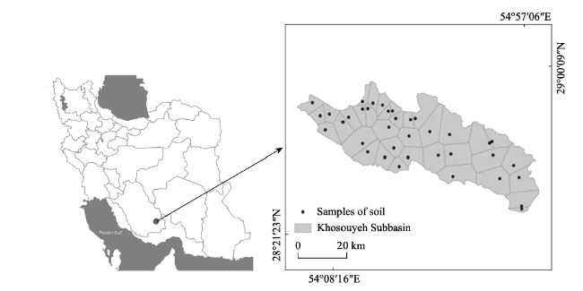
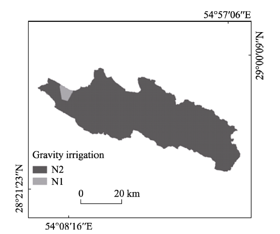
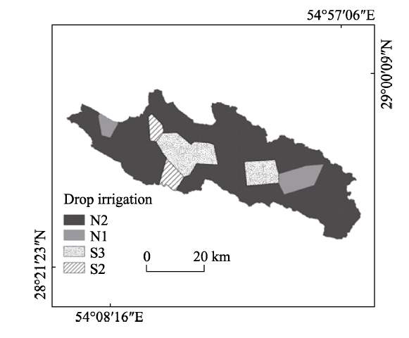
Today, the world's population is rising dramatically, and in line with this increase in the population of food and agricultural products, there must be an increasing in the number of problems associated with this process of agricultural land. Then it is necessary to use the maximum potential of this lands that product maximum yield without any damage. To reach this objective, land suitability evaluation is the most important way that can reach human to this objective. The main objective of this research was to compare different irrigation methods based on a parametric evaluation system in an area of 221402 ha in the Khosouyeh Subbasin of the Fars province, in the south of Iran. After preparing land unit map, 37 points were selected for sampling. Soil properties were evaluated and analyzed. Suitability maps for drop and gravity irrigation were generated using GIS technique. The results revealed land suitability of 98.42% of the case study was classified as permanently not suitable (N2) and 1.52% currently not suitable (N1) for gravity irrigation. On the other hand, land suitability of 77.73% of the case study was classified as permanently not suitability (N2), 6.05% currently not suitable (N1), 12.43% marginally suitable (S3) and 3.79% moderately suitable (S2) for drop irrigation. The limiting factors for both kinds of drop and gravity irrigation are soil depth and slope of land.

Cite this article

Masoud MASOUDI , Reza ZARE . Different Irrigation Methods and Their Comparisons Based on the Parametric Evaluation Method in Khosouyeh Dam Subbasin, Iran[J]. Journal of Resources and Ecology, 2019 , 10(5) : 504 -510 . DOI: 10.5814/j.issn.1674-764X.2019.05.005

1 Introduction

Regardless of the ability of natural resources and its values, it cannot provide humanitarian needs for primary and universal human beings around the world. The result of this way is irreparable damage to natural resource. For preventing damage land suitability should be determined for everywhere. It may not be the only solution, but certainly it is one of the most important and applicable way to challenge with this problem. 15% of agricultural lands are irrigated but it product 50% of agricultural crop and world food. This shows the importance of irrigation in agriculture. In Iran, agriculture consumes 92% of all water supplies per year and more than 80% of the ratio waste because of disuse of advance technology (EECM). That is why important to find those areas with more efficiency in water use. Generally all studies show methods of irrigation with more efficiency like drip and sprinkler methods are better than surface or gravity irrigation. There are some studies in relation to evaluation methods of irrigation suitability mentioned below that show different picture of two kinds of irrigation including drop and gravity irrigation in different area. In these regions suitability classes of irrigation can be increased with drip and sprinkler methods:
Briza et al. (2001) applied a parametric system (Sys et al., 1991) to evaluate land suitability for both surface and drip irrigation in the Ben Slimane Province, Morocco. Results showed that the largest part of the agricultural areas was classified as marginally suitable. Hired et al. (1996) and Bond (2002) improved the classification method for evaluating suitability for effluent irrigation and land suitability for irrigation. Results showed that factors that influenced the land suitability in irrigation practice included soil properties and topography. Tesafi (2002) investigated a land suitability method for gravity (surface) irrigation schemes in the sheeb area of Eritrea. According the result, in surface irrigation practice 16% of the study area was highly to moderately suitable (S1 and S2), 24% was classified moderately suitable (S2), 17% was marginally suitable (S3) and 40% of the area was decided as unsuitable. For surface irrigation, the main limiting factor for surface irrigation was soil salinity. Bazzani and Incerti (2002) also provided a land suitability evaluation for surface and drip irrigation systems in the province of Larche, Morocco, by using parametric evaluation systems. The results showed a large difference between applying the two irrigation methods. Bienvenue et al. (2003) evaluated the land suitability for surface (gravity) and drip (localized) irrigation in this region, in Senegal using the parametric evaluation system proposed by Sys et al. (1991). Results showed that under surface irrigation there was no area classified as highly suitable (S1). Only 20.24% of the study area proved suitable (S2, 7.73%) or slightly suitable (S3, 12.51%). most of the area (55.67%) was classified as unsuitable (N2). The limiting factor to this kind of land use was mainly the soil drainage status and texture that was mostly sandy while surface irrigation generally requires heavier soils. For drop and localized irrigation, a good portion (45.25%) of the area suitable (S2) while 25.03% was classified as highly suitable (S1) land and only a small portion was almost suitable (N1, 5.83%) or unsuitable (N2, 5.83%) in the latter case, the handicap is given by the shallow soil depth, bad texture due, to a large amount of coarse gravel and/or poor drainage. Mbodj et al. (2004) performed a land suitability evaluation for two types of irrigation, i.e., surface irrigation and drip irrigation, in the Tunisian Oued Rmel Catchment using the suggested parametric evaluation. They found that the drip irrigation suitability gave more irrigable areas compared to the surface irrigation practice. Barberis and Minelli (2005) provided land suitability classification for both surface and drip irrigation systems in Shouyang county, Shanxi province, China. The results indicated that due to the unusual morphology, the area suitable for the surface irrigation (34%) is smaller than the land that could be used for the drip irrigation (62%). Dengiz (2006) also compared different irrigation methods including surface and drip irrigation in the pilot fields of I˙kizce central research institute, located in south of Ankara, Turkey. This researcher has concluded that the drip irrigation method increased the land suitability by 38% compared to the surface irrigation method. Liu et al. (2006) evaluated the land suitability for surface and drip irrigation in the Danling County, Sichuan province, China, using a Sys’s parametric evaluation system. Results showed that drip irrigation was everywhere more suitable than surface irrigation due to the minor environmental impact that it caused. Albaji et al. (2007) carried out a land suitability evaluation for surface and drip irrigation in the Shavoor plain, in Iran. The results showed that 41% of the area was suitable for surface irrigation; 50% of the area was highly recommended for drip irrigation. Due to soil salinity and drainage problem the rest was not considered suitable for either irrigation method. Albaji et al. (2010) investigated different irrigation methods based upon a parametric evaluation system in an area of 29300 ha in the Abbas plain located in the Elam province, in the West of Iran. The results demonstrated that by applying sprinkler irrigation instead of surface and drip irrigation methods, the arability of 21250 ha (72.53%) in the Abbas plain will improve. Gholami & Delavari (2012) evaluated the land suitability for drip and surface irrigation methods at Shirin Abad, Shoushtar that located in the province of Khouzestan. The results of parametric evaluation system showed that 83.6% of land is suitable for surface irrigation and 90.8% is suitable for drip irrigation and 6.2% of the land is unsuitable for both irrigation methods and factor of restrictions were introduced in salinity and soil alkalinity. Fatapour and Eslami (2014) investigated comparison of suitability of two methods of sprinkler and drip irrigation based on the parametric method in Kouhdasht plain located in Lorestan province, in the west of Iran. The results showed that all of arable lands were considered suitable for drip irrigation and classified as class S1. Bagherzadeh and Paymard (2015) investigated land capability for different types of irrigation systems including surface, drip, and sprinkler practices by parametric and fuzzy approaches to evaluate the capability of cultivated lands on 6131 km2 of the Mashhad Plain, Khorasan Razavi Province, northeast Iran. Results showed that the land capability indices were in higher classes (S1 to S2) by drip and sprinkler irrigation compared to the surface irrigation system and the soil texture was detected as the most limiting factor for using the surface irrigation system. With respect to current soil and climate conditions in the study area, the most efficient irrigation systems are drip and sprinkler practices. Albaji et al. (2016) evaluated a suitable irrigation plan based upon a parametric evaluation system for an area of 1325 ha in the Ghaleh madreseh plain, Iran. The obtained results showed that sprinkler and drip irrigation were highly appropriate methods for 682.3 ha (51.5%) of the study area. Abd El-Aziz (2018) evaluated Land suitability analysis can help to achieve sustainable crop production with a proper use of the natural resources. The results also revealed that the studied area has a good potential to produce the selected crops under irrigation provided that the water requirements for these crops are met Dengiz and Usul (2018) Land evaluation analysis is a prerequisite to achieving optimum utilization of the available land resources. Finally, after determination of land suitability distribution classes for the study area,. it was found that 15.0% of the study area has highly (S1) and moderately (S2) while, 85% of the study area has marginally suitable and unsuitable coded as S3 and N. Kazemia and Akincib (2018) evaluated analyze the land use suitability of Golestan Province, located in the northeast of Iran, for rainfed farming performance using Geographic Information System (GIS) and Multi-criteria Decisionmaking Analysis (MCDA). According to the results of land suitability analysis, development of rainfed farming is possible for up to 56 percent of the current land of Golestan Province (about 396550.5 ha) in the southern and central areas as a long belt from east to west. The results showed that some climatic variables such as temperature, annual rainfall, and sunshine hours were not limiting factors for rainfed farming in this region.
The main objective of this research was to evaluate and compare land suitability for gravity and drop irrigation methods based on the parametric evaluation system for Khosouyeh Dam Subbasin, Iran. According to mentioned results of literatures in this section and taking into consideration of ecological condition especially soil and topography, it is assumed most of the region is under not suitable but using specific assessment model of suitability for drop irrigation can show parts of regions that are suitable for this kind of irrigation.

2 Materials and methods

This research was conducted in an area of 221402 ha in the Khosouyeh Subbasin of the Fars province, in the south of Iran (Fig. 1). The case study is located 28°26ʹ51ʺ N to 28°54ʹ36ʺ N and 53°58ʹ40ʺ E to 55°01ʹ01ʺ E. The elevation ranges between 1053-2986 m, average annual precipitation is 323.1 mm, average annual evaporation is 2606.7 mm and the current land use is pasture.

Fig. 1 Location of Khosouyeh Subbasin in Iran and their land units based soil samples

Sys et al. (1991) suggested a parametric evaluation system for irrigation method based on physical and chemical soil properties. In their proposed system there are six parameters and has been shown in the equation below:
$CI=A\times \frac{B}{100}\times \frac{C}{100}\times \frac{D}{100}\times \frac{E~}{100}\times \frac{F}{100}$
where A, B, C, D, E and F are soil texture rating, soil depth rating, calcium carbonate content rating, electrical conductivity rating, drainage rating and slope rating, respectively. 37 points were selected for sampling.
In table 1 the range of capability index (CI) and in table 2-7 the factors and their classes are seen. At first, land unit map was prepared by overlaying three maps: elevation, slope and aspect maps. After that according to the land unit map ten points were selected for sampling. The factors are measured and the values were allocated to each of them. When the factors were valued the Capability index for irrigation were calculated and the numerical values of the Capability index were allocated for corresponding suitability classes.
Table 1 Suitability classes for the irrigation capability indices (CI) classes
Capability index Definition Symbol
> 80 Highly Suitable S1
60-80 Moderately Suitable S2
45-59 Marginally Suitable S3
30-44 Currently Not Suitable N1
< 29 Permanently Not Suitable N2
Table 2 Soil depth rating for two kinds of gravity and drop irrigation
Soil depth
(cm)
Rating for gravity irrigation (%) Rating for drop irrigation (%)
<20 30 30
20-50 60 70
50-80 80 90
80-100 90 100
>100 100 100
Table 3 Textural classes rating for two kinds of gravity and drop irrigation
Textural classes Rating for gravity irrigation Rating for drop irrigation
Fine gravel (%) Coarse gravel (%) Fine gravel (%) Coarse gravel (%)
<15 15-40 40-75 15-40 40-75 <15 15-40 40-75 15-40 40-75
Clay Loam (CL) 100 90 80 80 50 100 90 80 80 50
Silty Loam (SiL) 100 90 80 80 50 100 90 80 80 50
Sandy Clay Loam (SCL) 95 85 75 75 45 95 85 75 75 45
Loam (L) 90 80 70 70 45 90 80 70 70 45
Silty Loam (SiL) 90 80 70 70 45 90 80 70 70 45
Silty (Si) 90 80 70 70 45 90 80 70 70 45
Silty Clay (SiC) 85 95 80 80 40 85 95 80 80 40
Clay (C) 85 95 80 80 40 85 95 80 80 40
Sandy Clay (SC) 80 90 75 75 35 95 90 85 80 35
Sandy Loam (SL) 75 65 60 60 35 95 85 80 75 35
loamy Sand (LS) 55 50 45 45 25 85 75 55 60 35
Sandy (S) 30 25 25 25 25 70 65 50 35 35
Table 4 CaCO3 amount rating for two kinds of gravity and drop irrigation
CaCO3 (%) Rating for gravity irrigation Rating for drop irrigation
<0.3 90 90
0.3-10 95 95
10-25 100 95
25-50 90 80
>50 80 70
Table 5 Elecrto-conductivity rating for two kinds of gravity and drop irrigation
EC (ds m-1) Rating for gravity irrigation Rating for drop irrigation
C, SiC, S, SC textures Other
textures
C, SiC, S, SC textures Other
textures
< 4 100 100 100 100
4-8 90 95 95 95
8-16 80 50 85 50
16-30 70 35 75 35
> 30 60 20 65 20

Note: C: clay; SiC: silty clay; S: sand; SC: sandy clay

Table 6 Drainage classes rating for two kinds of gravity and drop irrigation
Drainage classes Rating for gravity
irrigation
Rating for drop
irrigation
C, SiC, SC textures Other
textures
C, SiC, SC textures Other
textures
Well drained 100 100 100 100
Moderately drained 80 90 100 100
Imperfectly drained 70 80 80 90
Poorly drained 60 65 70 80
Very poorly drained 40 65 50 65
Drainage status not known 70 80 70 80

Note: C: clay; SiC: silty clay; SC: sandy clay

Table 7 Slope rating for two kinds of gravity and drop irrigation
Slope classes
(%)
Rating for gravity irrigation Rating for drop irrigation
Non-Terraced Terraced Non-Terraced Terraced
0-1 100 100 100 100
1-3 95 95 100 100
3-5 90 95 100 100
5-8 80 95 90 100
8-16 70 85 80 90
16-30 50 70 60 70
>30 30 50 40 50

3 Results

There is a freshwater river in center of case study and any irrigation system is not seen. Fig. 2 and Fig. 3 show land suitability maps for different irrigation methods. In table 8 for drop irrigation results revealed the most part about 172098 ha (77.73%) are classified as permanently not suitable (N2), 13403 ha (6.05%) Currently not suitable (N1), 27510 ha (12.43%) marginally suitable (S3) and, 8391 ha (3.79%) moderately suitable (S2). Then about 185501 ha of all are classified as not suitable. The average capability index (CI) for drop irrigation is 18.012 that is classified as currently not suitable.

Fig. 2 Land suitability map for gravity irrigation

Fig. 3 Land suitability map for drop irrigation

Table 8 Distribution of gravity and drop irrigation suitability

Suitability
Drop irrigation Gravity irrigation
Area (ha) Ratio (%) Area (ha) Ratio (%)
N2 172098 77.73 218040 98.48
N1 13403 6.05 3362 1.52
S3 27510 12.43
S2 8391 3.79
Total 221402 100 221402 100
Land suitability for gravity irrigation is similar to drop irrigation with a little difference. 218040 ha (98.48%) of the case study was classified as permanently not suitable (N2) and 3362 ha (1.52%) currently not suitable (N1) for gravity irrigation. Then about 221402 ha of all are classified as not suitable. The average capability index (CI) for gravity irrigation is about 6.172 and it means this area are classified as permanently not suitable (N2).
In table 9, for drop irrigation the highest value of capabil- ity index (CI) is 64 that is marginally suitable (S2), but this class has a little area that is related to land unit 7. On the other hand, the lowest value is 1.8 that is permanently not suitable (N2) and this class is related to land unit 14 and 23.
Table 9 CI values and suitability classes in gravity and drop irrigation for each land units
Class of
land unit
Gravity irrigation Drop irrigation Class of
land unit
Gravity irrigation Drop irrigation
CI Suitability class CI Suitability class CI Suitability class CI Suitability class
1 3.27 N2 3.52 N2 20 9.36 N2 10.23 N2
2 7.48 N2 9.50 N2 21 4.68 N2 5.11 N2
3 3.27 N2 3.52 N2 22 4.68 N2 5.11 N2
4 23.30 N2 28.20 N2 23 3.27 N2 1.80 N2
5 3.27 N2 3.52 N2 24 5.46 N2 2.86 N2
6 10.92 N2 9.55 N2 25 6.17 N2 56.90 S3
7 6.48 N2 64.00 S2 26 3.78 N2 50.50 S3
8 2.80 N2 3.78 N2 27 5.76 N2 56.00 S3
9 3.27 N2 3.52 N2 28 3.24 N2 31.50 N1
10 3.27 N2 3.52 N2 29 0.76 N2 16.06 N2
11 5.46 N2 5.88 N2 30 5.18 N2 25.20 N2
12 4.68 N2 59.50 S2 31 2.80 N2 3.78 N2
13 4.16 N2 57.80 S3 32 4.68 N2 6.30 N2
14 2.10 N2 1.80 N2 33 2.80 N2 3.78 N2
15 2.10 N2 2.26 N2 34 30.12 N1 35.28 N1
16 3.27 N2 2.86 N2 35 3.27 N2 28.00 N2
17 4.21 N2 4.60 N2 36 8.73 N2 10.58 N2
18 20.40 N2 24.70 N2 37 5.46 N2 5.88 N2
19 5.46 N2 5.88 N2
For gravity irrigation, the highest value of capability index (CI) is 30.12 that is classified as currently not suitable (N1) and this allocates to land unit 34. The lowest value is 0.76 that is classified as permanently not suitable (N2) and it is related to land unit 29.

4 Discussion and conclusions

The policy of expanding irrigated agriculture is one main cause of soil salinity in Iran. Lack of proper water management, has resulted in low water use efficiency. A combination of 60% conveyance efficiency and 50% application efficiency, leading to an overall efficiency of 30%, is usually reported in official reports (Masoudi, 2010). Drop and sprinkler methods of applying water will work best for increasing water use efficiency. This aim needs land capability evaluation for such irrigation methods. So, classification of land capability using physical and chemical land properties is a prerequisite process for uses management. The land capability evaluation involves multi factors, which are in different scales ranging from nominal to ratio. Geospatial technologies have been utilized for handling such a complex phenomenon for long (Jokar et al. 2015).
The main objective of this work was the implementation and comparison of different irrigation methods based on a parametric evaluation system in order to better planning for water management. Soil properties including soil texture, soil depth, calcium carbonate content, electrical conductivity, drainage and slope were evaluated and analyzed based on the model. This model is evaluated to two kinds of irrigation including “drop and gravity”. Suitability maps for drop and gravity irrigation showed all parts of the study is not suitable for gravity irrigation because of slope limitation but using drop irrigation decrease this limitation and other kinds of problems and make some parts of study area marginally suitable for irrigated agriculture in general, the results showed that the study area is not suitable for irrigation. Of course, these results may be related to the method of evaluation, which is strictly limited and is more rigorous than other methods. On the other hand, results of Gholami and Delavari (2012); Fatapour and Eslami (2014) using the parametric evaluation (Sys et al., 1991) Showed that their study areas are in good condition for irrigation and have relatively good environmental conditions for crop cultivation. Also, such areas will be the area needing immediate attention for remedial measures for reclamation and conservation for each type of degradation like those measures mentioned by Masoudi and Jokar (2017) and Masoudi et al. (2017).
[1]
Abd El-Aziz S . 2018. Evaluation of land suitability for main irrigated crops in the North-Western region of Libya. Eurasian Journal of Soil Science, 7(1):73-86.

[2]
Albaji M, Boroomand Nasab S, Moravej K . 2007. Land Suitability Evaluation for Surface and Drip Irrigation in Shavoor Plain. Iran Journal of Applied Sciences, 8(4):654-659.

[3]
Albaji M, Boroomand Nasab S, Naseri A , et al. 2010. Comparison of different irrigation methods based on the parametric evaluation approach in Abbas plain—Iran. Journal of Irrigation and Drainage Engineering. 136(2):131-136.

[4]
Albaji M, Golabi M, Hooshmand A R , et al. 2016. Investigation of surface, sprinkler and drip irrigation methods using GIS. Jordan Journal of Agricultural Sciences, 12:211-222.

[5]
Bagherzadeh A, Paymard P . 2015. Assessment of land capability for different irrigation systems by parametric and fuzzy approaches in the Mashhad Plain, northeast Iran. Soil and Water Research, 10:90-98.

[6]
Barberis A, Minelli S . 2005. Textbook of land evaluation in the Shenyang County, Shanxi Province, China. Institute of Agronomic Overseas, Florence, Italy, 19:56-94.

[7]
Bazzani F, Incerti F . 2002. Textbook of land evaluation in the province of larache, Morocco. Institute of Agronomic Overseas, Florence, Italy, 17:29-48.

[8]
Bienvenue J S, Ngardeta M, Mamadou K . 2003. Textbook of land evaluation in the province of Thies, Senegal. Institute of Agronomic Overseas, Florence, Italy, 23:112-127.

[9]
Bond W J. . 2002. Assessing site suitability for effluent plantion in: soil physical measurement and interpretative for land evaluation. CSIRO Publishing, 351-359.

[10]
Briza Y, F Dileonardo, Spisni A . 2001. Textbook of land evaluation in the province of Ben Slimane, Morocco. Institute of Agronomic Overseas, Florence, Italy, 21:28-53.

[11]
Chen D, De Bari C, De Santis S , et al. 2006. Land Evaluation in Danling County, Sichuan Province, China. Institute of Agronomic Overseas, Florence, Italy, 26:1-151.

[12]
Dengiz O, Usul M . 2018. Multi-criteria approach with linear combination technique and analytical hierarchy process in land evaluation studies. Eurasian Journal of Soil Science, 7(1):20-29.

[13]
Dengiz O . 2006. A Comparison of different irrigation methods based on the parametric evaluation approach. Turkish Journal of Agriculture and Forestry, 30:21-29.

[14]
Fatapour E, Eslami H . 2014. Locating suitable areas for pressurized irrigation systems using GIS. Bulletin of Environment, Pharmacology and Life Sciences, 3:153-156.

[15]
Gholami A, Delavari A . 2012. Evaluation of the two methods of surface and drip irrigation based on the Parametric System. Journal of Basic and Applied scientific Research, 2(6):5988-5992.

[16]
Hired C, Thamson A, Beer I . 1996. Selection and monitoring of site intended for irrigation whit claimed water in proceedings, water TECH Sydney. Australian water and wastewater association, Sydney, Australia.

[17]
Jokar P, Masoudi M, Fallah Shamsi S R , et al. 2015. Developing a model for ecological capability evaluation of ecotourism—A case study of Jahrom Township, Iran. International Journal of Scientific Research in Environmental Sciences, 3(1):1-8.

[18]
Kazemia H, Akincib H . 2018. A land use suitability model for rainfed farming by Multi-criteria Decisionmaking Analysis (MCDA) and Geographic Information System (GIS). Ecological Engineering, 116:1-6.

[19]
Masoudi M. . 2010. Risk assessment and remedial measures of land degradation, In Parts of Southern Iran. Lambert Academic Publishing (LAP), Germany.

[20]
Masoudi M, Jokar P, Sadeghi M . 2017. Land use planning using a quantitative model and Geographic Information System (GIS) in Darab County, Iran. Journal of Materials and Environmental Sciences, 8:2975-2985.

[21]
Masoudi M, Jokar P . 2017. A new model for desertification assessment using Geographic Information System (GIS) —A case study of Runiz Basin, Iran. Polish Journal of Ecology, 65:236-246.

[22]
Mbodj C, Mahjoub I, Sghaiev N . 2004. Textbook of land evaluation in the Oued Rmel Catchment, Tunisia. Institute of Agronomic Overseas, Florence, Italy, 21:41-72.

[23]
Sys C, Van Ranst E, Debaveye J . 1991. Land evaluation, part l, principles in land evaluation and crop production calculations. Agricultural Publications, Nr. 7, G.A.D.C, Brussels, Belgium.

[24]
Tesafi M . 2002. Land suitability system for spate irrigation schemes in Eritrea. Soil Use and Management, 18:77-78.

Outlines

/