Resources and Ecology in the Qinghai-Tibet Plateau

Quantitative Classification and Ordination of Plant Communities in the Upper and Middle Reaches of the Yarlung Zangbo River Basin

  • WANG Tong , 1, 2 ,
  • WANG Jingsheng , 1, 2, * ,
  • DING Yuke 3 ,
  • LIU Wenjing 4 ,
  • BAO Xiaoting 4 ,
  • LI Chao 1, 2
Expand
  • 1. Qianyanzhou Ecological Research Station, Key Laboratory of Ecosystem Network Observation and Modeling, Institute of Geographic Sciences and Natural Resources Research, Chinese Academy of Sciences, Beijing 100101, China
  • 2. University of Chinese Academy of Sciences, Beijing 100049, China
  • 3. Forest Inventory and Planning Institute of Tibet Autonomous Region, Lhasa 850000, China
  • 4. School of Environment and Natural Resources, Renmin University of China, Beijing 100872, China
*Corresponding author: WANG Jingsheng,

First author: WANG Tong, E-mail:

Received date: 2019-01-07

  Accepted date: 2019-04-10

  Online published: 2019-07-30

Supported by

The 13th Five-year National Key Research and Development Program of China (2016YFC0502006).

Copyright

All rights reserved

Abstract

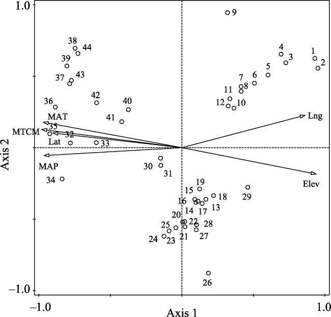
Based on vegetation survey data and environmental data of the Yarlung Zangbo River Basin, we conducted a quantitative ecological analysis of the vegetation community composition and the relationship between species and the environment in the study area. The results showed that 44 sampling sites and 68 plant species in the study area can be classified into seven subtypes: Artemisia minor + Stipa purpurea; Artemisia demissa + Stipa purpurea + Artemisia wellbyi; Kobresia pygmaea; Trikeraia hookeri; Sophora moorcroftiana + Cotoneaster multiflorus + Pennisetum centrasiaticum; Artemisia frigida; Potentilla fruticosa + Orinus thoroldii. Detrended correspondence analysis (DCA) indicated that both longitude and altitude play important roles in site and species distribution patterns. In addition, canonical correspondence analysis (CCA) revealed that in the upper and middle reaches of the Yarlung Zangbo River Basin, changes in temperature and precipitation caused by longitude are the main factors controlling the formation and transition of vegetation community types. Moreover, natural vegetation could be divided into three types: desert steppe community (source area), alpine steppe community (middle reaches region), and shrub community (confluence of Yarlung Zangbo River and Nyangqu River).

Cite this article

WANG Tong , WANG Jingsheng , DING Yuke , LIU Wenjing , BAO Xiaoting , LI Chao . Quantitative Classification and Ordination of Plant Communities in the Upper and Middle Reaches of the Yarlung Zangbo River Basin[J]. Journal of Resources and Ecology, 2019 , 10(4) : 389 -396 . DOI: 10.5814/j.issn.1674-764X.2019.04.006

1 Introduction

The Yarlung Zangbo River originates from the Jemayangzong Glacier in the northern foothills of the Himalayas in southwestern Tibet. It bypasses the Namjagbrawa at the easternmost end of the Himalayas, and exits China via Baxika. After merging with the other two rivers in Assam, India, it is called the Brahmaputra River; and when it flows through Bangladesh, it is called the Jamuna River. Finally, it joins the Ganges River in Guarantokad and enters the Bay of Bengal, with a total length of 2900 km (Zhang et al., 2009). The Yarlung Zangbo River is the longest river plateau in China and one of the highest in the world (Wang et al., 2015). Its drainage area is 2.42×10⁵ km2, which accounts for 20% of the total area of the Tibet Autonomous Region. It is regarded as the “mother river” by Tibetan compatriots.
In recent years, due to the dual effects of human intervention and climate change, the trend of land desertification in the Yarlung Zangbo River Basin has been curbed to somedegree. Meanwhile, the area of severe desertification has decreased slightly, and the utilization rate of lightly desertified land has increased. At present, research on the Yarlung Zangbo River Basin mainly focuses on four aspects: vegetation nutrient elements, biomass dynamics, vegetation cover monitoring, and the impacts of climate change and human disturbance on species as well as landforms (Chen et al., 2012; Yang et al., 2013; Yang et al., 2014; Yu et al., 2015; Wei et al., 2015). In terms of quantitative ecological aspects, correlation studies are relatively rare, and such approaches have only been used previously in Lazi County, Linzhou County, Lhasa Valley, and Shigatse (Li et al., 2004; Shen et al., 2012; La et al., 2014; Yao et al., 2018). In addition, the Yarlung Zangbo River Basin has a wide area and a long coastline. The basin has complex topography and landscape features, and diverse climatic conditions, so the types and distribution characteristics of the vegetation communities are unclear, especially in the source area. Through the classification of vegetation, the local cold-resistant and drought- resistant sand-fixing pioneer species and dominant species that are suitable for the fragile alpine ecosystems can be selected. Combined with the comprehensive analysis of vegetation growth characteristics and climate, such an analysis has a guiding significance for the restoration and reconstruction of sandy vegetation.
Quantitative classification objectively reveals the close relationships between vegetation types, and between vegetation types and the natural environment, which reflects certain ecological laws, provides a theoretical basis for the environmental interpretation of vegetation types, and facilitates the regional management of vegetation resources. As research has continued, new methods are emerging. Currently, the main methods of quantitative classification are hierarchical clustering, hierarchical division, non-hierarchical classification, fuzzy mathematics, community arrangement classification, and external classification (Ahmad, 2011; Saatkamp and Dutoit, 2010; Oldeland et al., 2010; Dale et al., 2007). Two-way-indicator species analysis (TWINSPAN) is the most widely used method for identifying specific ecological conditions according to indicator species and classifying species and samples at the same time (Zang et al., 2010). Ordination methods arrange species, communities or sample sites in low latitude space by reducing latitude, and they explain the relationships between species distribution and the environment according to the ecological gradient reflected by the ordination axis (Suri et al., 2010). The main methods include principal component analysis (PCA), canonical correspondence analysis (CCA), de-trend correspondence analysis (DCA) and de-trend canonical correspondence analysis (DCCA). The DCA ordination method usually uses multiple axes to reflect different ecological gradients, and it combines regression and correlation analyses to interpret the ordination results, which make it superior to other methods in describing community relationships (Ermakov and Makhatkov, 2011). CCA is a sorting method based on the single- peak model. Sample, vegetation and environmental factors are presented together in the same sorted map, which is more conducive to the study of relationships between vegetation and environment. Based on the practical application of vegetation quantity, classification and ordination methods are usually combined, and a variety of different results have been achieved. They are not only widely used in forest, wetland, grassland, shrub, and desert plants (Chen et al., 2014; Wang et al., 2013; Dong et al., 2007; Zhang et al., 2003), but they also play important roles in vegetation regionalization, community succession stage division, ecotype division and other fields. With the continuous development of GIS, remote sensing and other technologies, the combination of classification and ordination along with GIS has become an important means of vegetation ecological research.
Two-way indicator species analysis (TWINSPAN), canonical correspondence analysis (CCA), and de-trend correspondence analysis (DCA) were used in the present study to systematically analyze the species composition, community types, and distribution characteristics of vegetation in the upper and middle reaches of the Yarlung Zangbo River Basin, as well as their relationships with environmental factors. Ultimately, this study contributes to wider efforts to classify sand control vegetation, which will form the basis for strategic conservation planning and management.

2 Data and methods

2.1 Study area

The present study was conducted in the upper and middle reaches of the Yarlung Zangbo River Basin, including the main tributaries of the Maquan River, Dogxung Zangbo River, and Nyangqu River (Fig. 1). The climate in the study area is dry and cold, with scarce precipitation, and it is characterized as a cold temperate zone. Thus, the annual average temperature is between -1.5 ℃ and 8.5 ℃ (Ge et al., 2013), the diurnal extreme temperature is between -44.6 ℃ and 30.3 ℃ (Nie et al., 2012), and the hottest monthly average temperature is below 15 ℃. The mean annual precipitation is about 200 mm to 600 mm (Jia et al., 2008), and the precipitation in the rainy season (May‒October) accounts for about 80% of the annual precipitation. Soil types in this region are diverse, mostly composed of alpine soils, but also including frozen soil, black clay, felt soil, cold calcareous soil, and other types, which show vertical distribution characteristics (Wen et al., 2000). From the middle reaches to the source region, the vegetation types are successively shrub grassland, alpine meadow, alpine grassland, desert grassland, and alpine desert (Zhang et al., 2008). Alpine shrubs are mainly distributed in the Shigaze and the Nyangqu River along the main stream of the Yarlung Zangbo River, with Sophora moorcroftiana, Potentilla parvifolia, and Caragana versicolor being the main species (He et al., 2005). Grassland is mainly represented by Trikeraia hookeri, Orinus thoroldii, Stipa purpurea, and Pennisetum centrasiaticum. The meadow is dominated by Kobresia pygmaea and Kobresia littledalei.
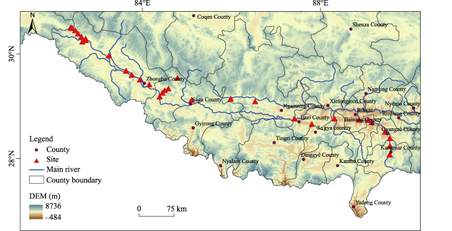
Fig. 1 Schematic diagram of the study area (the upper and middle reaches of the Yarlung Zangbo River) and sampling sites

2.2 Community survey

The two survey routes were as follows: (i) from the source of the Yarlung Zangbo River, along national highway 219 from northwest to southeast, we gradually passed through Hor - Paryang - Zhongba - Saga - Sangsang - Ngamring - Lhatse - Shigaze; and (ii) along provincial highway 204, we passed through Shigaze - Bainang - Gyantse - Kangmar. The sampling sites along the highway were set up every 10 km using the traditional ecological survey method of point-line combination. In addition, the sample sites selected were those with low degrees of human disturbance to the habitat, good representativeness of the community, and close proximity to the river valley. Each site was 20 m × 30 m in size. A 5 m × 5 m shrub quadrat was set along the diagonal line (3 m from the corner) and the central point of the sample sites. A 1 m × 1 m herb quadrat was also set at the central point of the shrub quadrat. There were five duplicates in the shrub and herb quadrats, as shown in Fig. 2.
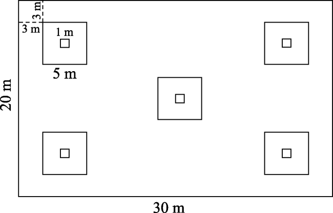
Fig. 2 Sample setting diagram
Basic information such as plant height, coverage, and cluster number were recorded by species. Furthermore, the latitude, longitude, and altitude of each quadrat were measured by GPS, and the slope and aspect of each quadrat were recorded using a Brunton compass.

2.3 Data processing

The formula for calculating the importance of a species in a quadrat was as follows (Shang et al., 2005):
Importance value = (relative coverage + relative height) × 100/2
The field survey was completed in August 2017 during the peak period of biomass. Two matrices were established according to the survey data: a vegetation matrix consisting of 68 importance values of species in 220 quadrats, and an environmental attribute matrix consisting of 44 sampling sites and six environmental parameters. TWINSPAN was conducted to classify the vegetation using WinTWINS software (version 2.3). We then conducted DCA and CCA using Canoco for Windows 5.0 to process the sample and environmental parameters.

3 Results

3.1 Plant community classification

The plant species in 220 quadrats were classified by TWINSPAN. According to the nomenclature principle of plant communities, community types are named by combining the ecological analysis of the survey results and the indicative or dominant species of the community. The classification results indicated that plant communities in the upper and middle reaches of the Yarlung Zangbo River Basin can be divided into seven categories, as shown in Fig. 3.
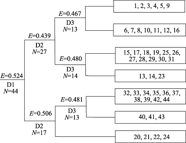
Fig. 3 Dendrogram of the TWINSPAN classification of 44 sites in the Yarlung Zangbo River Basin
3.1.1 Artemisia minor + Stipa purpurea community
There are six sampling sites in total. The established populations are Artemisia minor and Stipa purpurea. The dominant species are Carex moorcroftii, Potentilla asaundersiana, Saussurea tibetica, and Delphinium tangkulaense. This community is distributed in Mayomula, the source of the Yarlung Zangbo River, where the natural conditions are harsh and the altitude ranges from 4970 m to 5200 m. The coldest monthly mean temperature is -11.6 ℃ to 12.93 ℃, and the annual average temperature is 3.4 ℃ to 4.7 ℃. The soil types are gravel soil and rocky beach soil. There is a strong zonality in this community, so the slope has no obvious influence on the community type, and it is distributed at both the foot and top of the slope.
3.1.2 Artemisia demissa + Stipa purpurea + Artemisia wellbyi community
A total of seven sampling sites are included. The established populations are Artemisia demissa, Stipa purpurea, and Artemisia wellbyi. Most of them occur at altitudes of 4600 m to 4900 m (occasionally at 4200 m). The coldest monthly mean temperature is -9.1 ℃ to 9.6 ℃, and the annual average temperature is about 6.5 ℃. This community is mostly distributed in a relatively flat, gently sloping area.
3.1.3 Kobresia pygmaea community
This community is present at as many as 11 sampling sites. In each site, there are many diverse co-dominants, such as Potentilla saundersiana, Potentilla bifurca, Astragalus arnoldii, Elymus nutans, and Poa annua. This community was recorded between altitudes of 4500 m and 5081 m. This community grows in flat, sunny, and semi-positive slopes, and is it distributed at both the foot and middle of the slope. The average temperature of the coldest month is -0.9 ℃ to 7.9 ℃, and the average annual temperature is 7.5 ℃ to 10.9 ℃.
3.1.4 Trikeraia hookeri community
The Trikeraia hookeri community is represented by three sampling sites. The associated species are Elymus nutans, Kobresia tibetica, and Kobresia pygmaea. The community is distributed at an altitude of about 4500 m, and all of them grow in gentle, sandy land. The coldest monthly average temperature is -6.1 ℃ to 8.0 ℃, and the annual average temperature is about 7.5 ℃.
3.1.5 Sophora moorcroftiana + Cotoneaster multiflorus + Pennisetum centrasiaticum community
This community was found at 10 sampling sites. The dominant species is Sophora moorcroftiana, and the co-dominant species include Cotoneaster multiflorus and Pennisetum centrasiaticum. The associated species are Poa annua, Artemisia demissa, Artemisia wellbyi, Artemisia frigida, and several others. This community is mainly distributed in the large area where the Nianchu River and the Yarlung Zangbo River join. The altitude ranges from 3800 m to 4200 m. Flat land, semi-shady slopes, and semi-sunny slopes are all suitable places for growth, and the slope position has no effect on them. The average temperature in the coldest month is -4.5 ℃ to 5.5 ℃, and the annual average temperature is 14.4 ℃ to 16.2 ℃.
3.1.6 Artemisia frigida community
This community is present at three sampling sites. The species composition of this community type is quite variable. However, the habitats are very similar and the distribution is in the range of 4000 m to 4300 m. The only soil type is gravel soil. The coldest month average temperature is 1.7 ℃ to 4.7 ℃, and the annual average temperature is 11.1 ℃ to 14.1 ℃. This community is affected by farming and grazing. Furthermore, some grasses are foraged, so inedible plants such as Artemisia frigida dominate.
3.1.7 Potentilla fruticosa + Orinus thoroldii community
There are four sampling sites in total. The habitat where this community is located is narrow and gentle. The altitude ranges from 4500 m to 4600 m. The coldest month average temperature is 6.3 ℃ to 7.0 ℃, and the annual average temperature is 7.5 ℃ to 7.7 ℃.

3.2 DCA ordination of sampling sites

The DCA ordination results of 44 sampling sites in the upper and middle reaches of the Yarlung Zangbo River Basin are shown in Fig. 4. For the ordination axes, the horizontal axis reflects the trends of community changes with precipitation and longitude. In other words, longitude, precipitation, and temperature gradually increase from left to right. On the vertical axis, with the increase in altitude, the temperature decreases, and the community type changes from a Trikeraia hookeri community to an Artemisia demissa + Stipa purpurea + Artemisia wellbyi community and an Artemisia minor + Stipa purpurea community, which basically illustrates the gradient of altitude change. On the DCA ordination map, the distribution patterns for each community type are obvious: the alpine meadow and desert grassland vegetation community types in the source area of the Yarlung Zangbo River are on the left side of Fig. 4. With the increases in temperature and precipitation along the horizontal axis, the vegetation gradually transitions to the alpine grass-land and shrub grassland types. Furthermore, according to the distance of each community, the correlation between the communities can be judged. For example, the Trikeraia hookeri community is far away from other communities, indicating that it has a large difference in species composition compared with the others. The distribution of sampling sites 40, 41, and 43 is relatively scattered. Although these three sites all belong to the Artemisia frigida community, the species composition of this community is quite variable. However, the results of DCA and TWINSPAN classification revealed that there is no significant staggered distribution phenomenon between the different communities in the DCA ordination map. This shows that these two analyses can clearly distinguish different community structures and habitat characteristics, and that the classification results are credible.
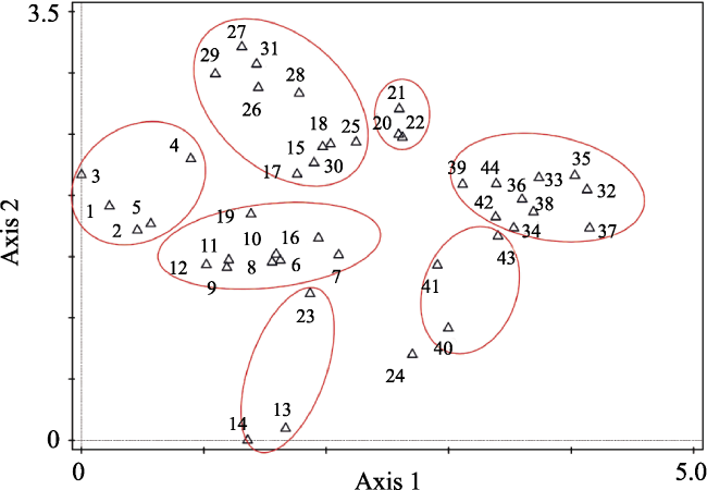
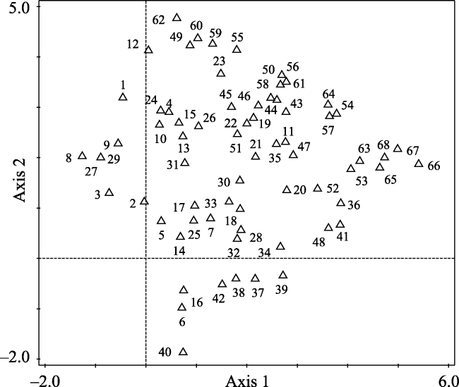
Fig. 4 Two-dimensional DCA ordination diagram of sampling sites in the Yarlung Zangbo River Basin

3.3 DCA ordination of species

According to the importance and frequency of species, DCA analysis was performed after removing the species which occurred only occasionally (those with a frequency of less than 5%). The distribution patterns of species in the DCA ordination map was confoundingly similar to those of community types (Fig. 5). From the horizontal axis of the species DCA ordination map, the left end is occupied by typical species such as Delphinium tangkulaense, Delphinium caeruleum, and Draba oreades, and cushion vegetation like Arenaria pulvinata, Artemisia minor, and Astragalus arnoldii growing in the source area of the Yarlung Zangbo River. While at the right end of the horizontal axis, the spe-cies are Pennisetum centrasiaticum, Fagopyrum tataricum, Carex moorcroftii, and Artemisia hedinii, which indicates that the horizontal axis represents environmental factors such as longitude, precipitation, and temperature. The variety of species across the distribution reflects the changes in climate characteristics from the arid and rainless climate at the source of the Yarlung Zangbo River Basin to the warm and humid climate of the Nyangqu River Basin. Species at the lower end of the vertical axis mainly include Lomatogo- nium carinthiacum, Potentilla anserina, Kobresia tibetica, Hierochloe odorata, Eragrostis pilosa, Aster himalaicus, and Trikeraia hookeri. While at the upper end of the vertical axis, there are mainly cold and drought-resistant species such as Carex brachyathera, Potentilla parvifolia, Pleurospermum hedinii, Blysmus sinocompressus, and Anaphalis xylorhiza. The decreasing trend in species height is obvious (data not shown), so it can be concluded that along the vertical axis, the altitude gradually increases while the temperature decreases.
Fig. 5 DCA ordination diagram of 68 species in the Yarlung Zangbo River
Notes: 1. Pennisetum centrasiaticum 2. Dracocephalum heterophyllum 3. Heteropappus semiprostratus 4. Oxytropis glacialis 5. Incarvillea younghusbandii 6. Artemisia wellbyi 7. Artemisia hedinii 8. Elymus nutans 9. Carex brachyathera 10. Onosma paniculatum 11. Artemisia minor 12. Androsace tapete 13. Pleurospermum hedinii 14. Arenaria pulvinata 15. Potentilla saundersiana 16. Potentilla bifurca 17. Oxytropis gerzeensis 18. Kobresia pygmaea 19. Carex infuscata 20. Orinus thoroldii 21. Androsace graminifolia 22. Blysmus sinocompressus 23. Eragrostis pilosa 24. Potentilla fruticosa 25. Potentilla anserina 26. Fagopyrum tataricum 27. Stipa roborowskyi 28. Delphinium caeruleum 29. Stellera chamaejasme 30. Lomatogonium carinthiacum 31. Poa crymophila 32. Artemisia frigida 33. Pedicularis verticillata 34. Oxytropis sericopetala 35. Lasiocaryum densiflorum 36. Hierochloe odorata 37. Astragalus densiflorus 38. Anaphalis xylorhiza 39. Phlomis younghusbandii 40. Taraxacum mongolicum 41. Heteropappus bowerii) 42. Carex moorcroftii 43. Trikeraia hookeri 44. Chamaerhodos sabulosa 45. Sophora moorcroftiana 46. Arenaria edgeworthiana 47. Delphinium tangkulaense 48. Lepidium capitatum 49. Astragalus arnoldii 50. Pedicularis wallichii 51. Astragalus acaulis 52. Saussurea tibetica 53. Kobresia tibetica 54. Urtica tibetica 55. Poa tibetica 56. Draba oreades 57. Hypecoum leptocarpum 58. Oxytropis pusilla 59. Artemisia demissa 60. Oxytropis microphylla 61. Potentilla parvifolia 62. Potentilla cuneata 63. Aster himalaicus 64. Festuca ovina 65. Rhodiola smithii 66. Dimorphostemon pinnatus 67. Swertia bimaculata 68. Stipa purpurea.

3.4 CCA ordination of sampling sites

The CCA ordination method was used to further quantitatively analyze the relationships between community distribution and environmental factors. The eigenvalue of CCA ordination axis 1 is 0.5227, which accounts for 8.63% of the cumulative variation of species, while the cumulative interpretation rate of the species-environment relationship is 34.41%. The correlation coefficient of the pseudo-canonical correlation is about 0.96. The total eigenvalue of ordination axis 2 is 0.3162, and the pseudo-canonical correlation coefficient is 0.92. Together with ordination axis 1, the cumulative interpretation rate of the species-environment relationship is 55.22%. These values show that, compared with the third and fourth axes, the first and second axes of the CCA ordination not only explain the variation in species and environments well, but they also reflect the change in vegetation types. The longitude and altitude are proportional to the first axis and have a high correlation coefficient. The latitude, the coldest average temperature, the annual average temperature, and the annual average precipitation are inversely proportional to the first axis and have a significant negative correlation. These relationships show that the hydrothermal conditions of the first axis become less favorable from left to right, and the relationships between the environmental factors and the vertical axis are not significant. In addition, altitude has a significant negative correlation with longitude, temperature, and precipitation, while longitude is the opposite, indicating that the change in the elevation and longitude gradient is the main factor affecting the water and thermal environmental conditions in the upper and middle reaches of the Yarlung Zangbo River Basin.
The CCA ordination results in Fig. 6 show that the vegetation in the study area is clearly divided into three large communities due to the differences in longitude. The first set of vegetation types (including sampling sites 1-12) is located in the source area of the Yarlung Zangbo River, which is characterized by the highest altitude, lower longitude, average annual temperature, and average annual precipitation. The second group of vegetation types (including sampling sites 13-31) is located in the middle reaches of the Yarlung Zangbo River. It represents a transitional vegetation from arid and cold regions to warm and humid regions and is composed of alpine grassland communities such as Orinus thoroldii, Artemisia wellbyi, and Carex moorcroftii. The third group of vegetation types (including sampling sites 32-44) is near the confluence of the Yarlung Zangbo River and the Nyangqu River. The elevation there is relatively low and the precipitation (> 400 mm) and temperature (> 8 ℃) are significantly higher than in the other two areas. In this region, the vegetation type is dominated by shrub grassland.
Fig. 6 CCA ordination diagram of sampling sites in the Yarlung Zangbo River Basin
Notes: Elev = elevation; Lat = latitude; MAP = mean annual precipitation; MAT = mean annual temperature; Lng = longitude; MTCM = mean temperature of the coldest month.

4 Discussion and conclusions

4.1 Discussion

4.1.1 Distribution characteristics of vegetation in the upper and middle reaches of the Yarlung Zangbo River Basin
The above results and community characteristics show that the communities in the upper and middle reaches of the Yarlung Zangbo River display distinct longitudinal zonal distribution patterns. With the increase in longitude, the vegetation type gradually evolved from desert steppe to alpine steppe, and then to shrub steppe, which is also consistent with the actual patterns observed. From a species perspective, there are many plants, such as Artemisia, Stipa, Orinus, Trikeraia, and Pennisetum, in the source of the Yarlung Zangbo River (Chen et al., 2016). In the middle reaches, the species are more diverse. In addition to Compositae, Gramineae, and Cyperaceae species, a large number of Rosa species, Sophora moorcroftiana, and other shrubs have become important groups (Li et al., 2013). The classification results in this paper are consistent with the above conclusions.
4.1.2 Longitude and elevation are the main factors influencing vegetation distribution
The distribution patterns of species are affected by various environmental factors. Altitude, topography, and soil have small-scale effects (Zhang et al., 2015), while precipitation and temperature have greater effects (Potter et al., 1998), and latitude, longitude, and altitude are known to determine heat and water distribution patterns (Yang et al., 2010). In the vast upper and middle reaches of the Yarlung Zangbo River basin, with the decrease of longitude, precipitation and temperature also decreased. Carex and Artemisia were gradually replaced by drought-resistant species. The change in the elevation gradient has a significant impact on the vegetation patterns in the Yarlung Zangbo River Basin. Some studies have shown that with an increase in elevation, the number of endemic species also increases (Kessler, 2002). The number of vegetation types decrease after an initial increase. The vegetation types at elevations of 3000-4000 m and 4000-5000 m are the most numerous (Chen et al., 2015). However, some studies suggest that natural and man-made disturbances are the most important factors affecting the current species distribution pattern, and they can significantly affect the changing species pattern on the vertical gradient (Nogués-Bravo et al., 2008). Although the history of human disturbance is relatively short compared with the impacts of long-term climate changes and geological movements on vegetation, it still has a serious impact on the natural ecosystem (Zhao et al., 2005). The main anthropogenic disturbance factors affecting the natural ecosystem in Yarlung Zangbo River Basin are grazing activities and farmland reclamation, which are also the main economic sources for this area. However, the Yarlung Zangbo River Basin has a vast territory, and the land area suitable for human activities is small and relatively concentrated. As a result, the anthropogenic disturbance factors have no significant impact on the distribution pattern of the vegetation communities. Therefore, the community types and their distribution patterns in the classification scheme in this paper basically represent the natural pattern of vegetation types in this region. The changes in hydrothermal conditions caused by longitude and altitude changes are still the key factors controlling the vegetation patterns.

4.2 Conclusions

The natural vegetation communities in the upper and middle reaches of the Yarlung Zangbo River were classified into seven types by the TWINSPAN method: Artemisia minor + Stipa purpurea; Artemisia demissa + Stipa purpurea + Artemisia wellbyi; Kobresia pygmaea; Trikeraia hookeri; Sophora moorcroftiana + Cotoneaster multiflorus + Pennisetum centrasiaticum; Artemisia frigida; Potentilla fruticosa + Orinus thoroldii.
The results of DCA ordination showed that with increases in longitude (horizontal axis), temperature and hydrothermal conditions are better. Furthermore, drought-resistant species communities such as Delphinium caeruleum, Arenaria pulvinata, and Artemisia minor gradually transition to Pennisetum centrasiaticum, Carex moorcroftii, Artemisia hedinii, and other communities. With increasing altitude, the climatic conditions tend to be colder and more humid, and species such as Kobresia pygmaea, Eragrostis pilosa, and Trikeraia hookeri are generally replaced by Carex moorcroftii, Potentilla parvifolia, Pleurospermum hedinii, and Anaphalis xylorhiza.
The CCA ordination results had a high cumulative interpretation rate for the species-environment relationship, and the vegetation is divided into three major community types: desert grassland communities such as Stipa capillata and Artemisia desertorum in the Yajiangyuan area, Orinus thoroldii and Carex moorcroftii alpine communities in the middle reaches of the Yarlung Zangbo River, and shrub and farmland communities which dominate at the confluence of the Yarlung Zangbo River and the Nyangqu River.
[1]
Ahmad S S.2011. Vegetation classification in Ayubia National Park, Pakistan using ordination methods. Pakistan Journal of Botany, 43(5): 2315-2321.

[2]
Chen B, Li H D, Cao X Z, et al.2016. Dynamic changes in vegetation coverage in the Yarlung Zangbo River basin based on SPOT-VGT NDVI.Mountain Research, 34(2): 249-256. (in Chinese)

[3]
Chen B, Li H D, Cao X Z, et al.2015. Vegetation pattern and spatial distribution of NDVI in the Yarlung Zangbo River basin of China.Journal of Desert Research, 35(1): 120-128. (in Chinese)

[4]
Chen P F, Li C L, Kang S C, et al.2012. The geochemical characteristics of sediments of the Yarlung Zangbo River. Geochimica, 41(4): 387-392. (in Chinese)

[5]
Chen Y, Wang H L, Han J W, et al.2014. Numerical classification, ordination and species diversity along elevation gradients of the forest community in Xiaoqinling.Acta Ecologica Sinica, 34(8): 2068-2075. (in Chinese)

[6]
Dale E E, Ware S, Waitman B.2007. Ordination and classification of bottomland forests in the lower Mississippi Alluvial Plain.Castanea, 72(2): 105-115.

[7]
Dong L S, Zhang X D, Zhou J X, et al.2007. Quantitative classification and ordination of shrub species and communities in a loess landscape of western Shanxi.Acta Ecologica Sinica, 27(7): 3072-3080. (in Chinese)

[8]
Ermakov N, Makhatkov I.2011. Classification and ordination of north boreal light-coniferous forests of the West Siberian Plain.Plant Biosystems - An International Journal Dealing with all Aspects of Plant Biology, 145(sup1): 199-207.

[9]
Ge S, Nima J, Ma P F, et al.2013. Temperature variation characteristics of the Yarlung Zangbo River Basin in the past 50 years.Tibet Science and Technology, (1): 46-50. (in Chinese)

[10]
He P, Guo K, Gao J X, et al.2005. Vegetation types and their geographic distribution in the source area of the Yarlung Zangbo.Mountain Research, 23(3): 267-273. (in Chinese)

[11]
Jia J Wi, Lü S Y, Wang Z X.2008.Analyzing the characteristics of the water resources over Yarlung Zangbo River basin.Yangtze River, 39(17): 71-72. (in Chinese)

[12]
Kessler M.2002. Range size and its ecological correlates among the pteridophytes of Carrasco National Park, Bolivia.Global Ecology and Biogeography, 11(2): 89-102.

[13]
La Q, Zhaxi C R, Zhu W D, et al.2014. Plant species-richness and association with environmental factors in the riparian zone of the Yarlung Zangbo River of Tibet, China.Biodiversity Science, 22(3): 337-347. (in Chinese)

[14]
Li H T, He J S, Ni Z C, et al.2004. A study on TWINSPAN classification of meadow plants in Lazi County, Tibet.Acta Agriculturae Universitatis Jiangxiensis, 26(1): 31-36. (in Chinese)

[15]
Li H, Wen X M, Yu S L.2013. Investigation and evaluation on germplasm resources of Vascular plants distributed in Qiangtang Plateau and upper area of Yarlungzangbo River. Plant Diversity, 35(3): 327-334. (in Chinese)

[16]
Nie N, Zhang W C, Deng C.2012. Spatial and temporal climate variations from 1978 to 2009 and their trend projection over the Yarlung Zangbo River Basin.Journal of Glaciology and Geocryology, 34(1): 64-71. (in Chinese)

[17]
Nogués-Bravo D, Araújo M. B, Romdal T, et al.2008. Scale effects and human impact on the elevational species richness gradients.Nature, 453(7192): 216-219.

[18]
Oldeland J, Dorigo W, Lieckfeld L, et al.2010. Combining vegetation indices, constrained ordination and fuzzy classification for mapping semi-natural vegetation units from hyperspectral imagery.Remote Sensing of Environment, 114(6): 1155-1166.

[19]
Potter D U, Gosz J R, Jr M C M, et al.1998. Lightning, precipitation and vegetation at landscape scale.Landscape Ecology, 13(4): 203-214.

[20]
Saatkamp A, Dutoit C R.2010. Plant functional traits show non-linear response to grazing. Folia Geobotanica, 45(3): 239-252.

[21]
Shang Z H, Yao A X, Long R J, et al.2005. Quantitative classification and ordination of the florae in the nuclear production region of Zhongwei goats,Ningxia.Acta Botanica Boreali-Occidentalia Sinica, 25(5): 985-990. (in Chinese)

[22]
Shen W S, Li H D, Lin N F, et al.2012. Screening trial for the suitable plant species growing on sand dunes in the alpine valley and its recovery status in the Yarlung Zangbo River basin of Tibet, China.Acta Ecologica Sinica, 32(17): 5609-5618. (in Chinese)

[23]
Suri G G, Zhang J T, Zhang B, et al.2010. Numerical classification and ordination of forest communities in the Songshan National Nature Reserve.Acta Ecologica Sinica, 30(10): 2621-2629. (in Chinese)

[24]
Wang H L, Zhang H G, Lv G H.2013. Quantitative classification and ordination of plant communities in Ebinur Lake Wetland. Journal of Arid Land Resources and Environment, 27(3): 177-181. (in Chinese)

[25]
Wang R, Yao Z J, Liu Z F, et al.2015. Changes in climate and runoff in the middle course area of the Yarlung Zangbo River Basin. Resources Science, 37(3): 619-628. (in Chinese)

[26]
Wei X, Deng Y, Zhang L L, et al.2015. Analysis of water temperature characteristics in middle reach of the Yarlung Zangbo River.Advanced Engineering Sciences, 47(S2): 17-23. (in Chinese)

[27]
Wen A B, Liu S Z, Fan J R, et al.2000. Soil erosion rate using 137Cs technique in the Middle Yalungtsangpo.Journal of Soil and Water Conservation, 14(4): 47-50. (in Chinese)

[28]
Yang X L, Zhao K T, Ma H P, et al.2010. Ecological studies on vegetation quantity in the semi-arid valley region of Lhasa.Scientia Silvae Sinicae, 46(10): 15-22. (in Chinese)

[29]
Yang Z G, Tang X P, Lu Y H, et al.2013. The changes of potential evaportranspiration over Yarlung Zangbo River Basin during 1961-2010.Acta Geographica Sinica, 68(9): 1263-1268. (in Chinese)

[30]
Yang Z G, Zhuo M, Lu H Y, et al.2014. Characteristics of precipitation variation and its effects on runoff in the Yarlung Zangbo River basin during 1961-2010.Journal of Glaciology and Geocryology, 36(1): 166-172. (in Chinese)

[31]
Yao S C, Wang J S, Ding L B, et al.2018. Quantitative classification and ordination of grassland communities in Lhasa River Valley.Acta Ecologica Sinica, 38(13): 4779-4788. (in Chinese)

[32]
Yu Z S, Tang S Y, Yundan N M.2015. Variation characteristics of climatic growing season in the middle course of Yarlung Zangbo River during 1971-2010.Plateau Meteorology, 34(2): 338-346. (in Chinese)

[33]
Zang R G, Jing X H, Ding Y, et al.2010. Quantitative classification, ordination and environmental analysis of woody plant communities in Xiaodonggou forest area of the Altai Mountain, Xinjiang.Scientia Silvae Sinicae, 46(2): 24-31. (in Chinese)

[34]
Zhang D Q, Xiao C D, Qin D H.2009. Himalayan glaciers fluctuation over the latest decades and its impact on water resources.Journal of Glaciology and Geocryology, 31(5): 885-895. (in Chinese)

[35]
Zhang G L, Zhang J T, Cheng L M.2003. Quantitative classification and ordination of Bothriochloa ischaemum communities in mountain area of south Shanxi.Acta Pratacultural Science, 12(3): 63-69. (in Chinese)

[36]
Zhang J, Tan J L, Deng L L, et al.2008. Investigation and assessment of the terrestrial vegetation in the middle Reaches of the Yarlung Zangbo River in Tibet.Forest Resources Management, 2008(4): 118-123. (in Chinese)

[37]
Zhang Y J, Cui L L, Pang Y Z, et al.2015. Classification and ordination of plant communities and the relationship between species richness and environmental factors in Lhasa valley.Chinese Journal of Ecology, 34(12): 3289-3299. (in Chinese)

[38]
Zhao C M, Chen W L, Tian Z Q, et al.2005. Altitudinal pattern of plant species diversity in Shennongjia Mountains, Central China.Journal of Integrative Plant Biology, 47(12): 1431-1449.

Outlines

/