Forest Ecosystem

Comparison of Soil Moisture in Different Soil Layers between Three Typical Forests in the Upper Reaches of Lijiang River Basin, Southern China

  • LI Haifang , 1, 2 ,
  • LIU Qinghua , 1, * ,
  • LI Shimei 1 ,
  • LI Wei 1 ,
  • YANG Jinming 1
Expand
  • 1. College of Landscape Architecture and Forestry, Qingdao Agricultural University, Qingdao, Shandong 266109, China
  • 2. School of Tourism, Guilin University of Technology, Guilin, Guangxi 541004, China
*Corresponding author: LIU Qinghua, E-mail:

First author: LI Haifang, E-mail:

Received date: 2018-02-04

  Accepted date: 2018-07-30

  Online published: 2019-05-30

Supported by

National Natural Science Foundation of China (41261006)

Copyright

All rights reserved

Abstract

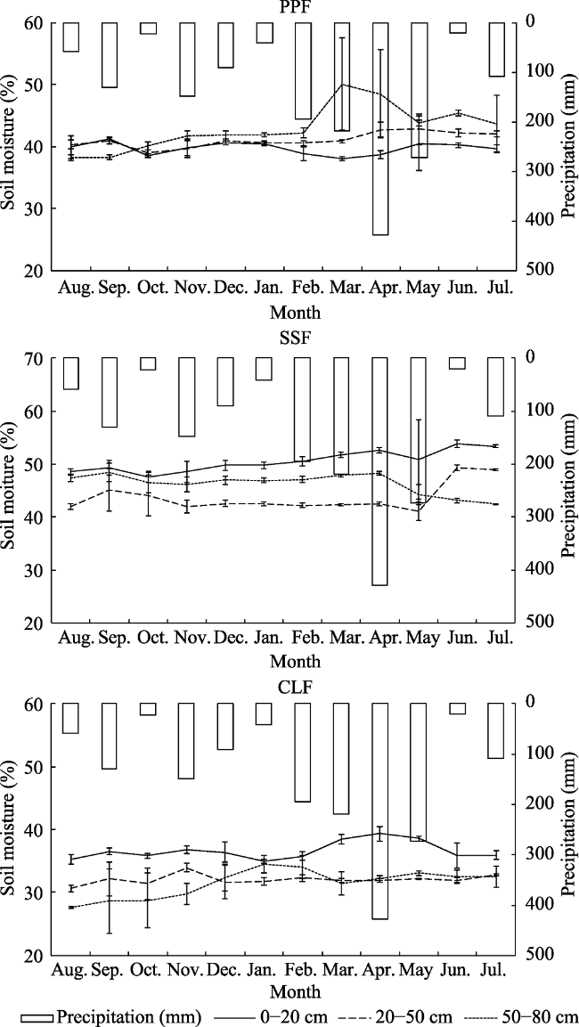
Throughfall, stemflow, evapotranspiration and infiltration are likely to vary with forest types, and consequently affect soil moisture regimes in different soil layers. In this study, the spatial and temporal characteristics of soil moisture were investigated to understand variations in soil moisture in three typical forests, including Phyllostachys pubescens forest (abbreviated as PPF), Schima superba forest (abbreviated as SSF) and Cunninghamia lanceolata forest (abbreviated as CLF) in the upper reaches of Lijiang River basin in southern China. The results showed that, (1) Litterfall and soil physical properties differed significantly in the three typical forests. Infiltration capacity in SSF was more favorable to soil moisture than in PPF and CLF. (2) Large variations were found in soil moisture at different forest stands and depths. Due to complicated vertical structures, there were obvious differences in soil moisture from the 0-20 cm soil layer to the 50-80 cm soil layer. (3) Average soil moisture in each layer was higher in SSF than in PPF and CLF. (4) Soil moisture in different layers correlated closely with precipitation (P<0.01) and the three typical forests had the same change trends with rainfall during the studying period. (5) In topsoil, soil moisture was influenced by soil properties which were mostly determined by litterfall, while in deep soil, soil moisture was affected by variations of soil characteristics, which were mostly determined by root distribution. This study provides a scientific basis for better understanding the relationships between forest vegetation and its hydrological effects, helping to facilitate water resources conservation and achieving wise forest management in the upper reaches of Lijiang River basin.

Cite this article

LI Haifang , LIU Qinghua , LI Shimei , LI Wei , YANG Jinming . Comparison of Soil Moisture in Different Soil Layers between Three Typical Forests in the Upper Reaches of Lijiang River Basin, Southern China[J]. Journal of Resources and Ecology, 2019 , 10(3) : 307 -314 . DOI: 10.5814/j.issn.1674-764X.2019.03.009

1 Introduction

Soil moisture is a key variable of forest ecosystems and is related to hydrological processes (Vereecken et al., 2014). Soil moisture controls the partitioning of rainfall to soil water flow and infiltration rate and, therefore, affects runoff, erosion, solute transport, and land-atmosphere interactions (Aubert et al., 2003). Soil moisture regimes are variable over space and time, and are influenced by a number of factors, such as precipitation (Famiglietti et al., 1998), topography (Wilson et al., 2005), land cover/vegetation (Mahmood and Hubbard, 2007; Fu and Chen, 2000), soil properties (Bell et al., 1980), and soil depth (Gwak and Kim, 2016). These influencing factors are likely to be intertwined in forest ecosystems. Forest types have synergistic effects on soil properties, and consequently exert great impacts on soil water and its spatial distribution patterns (Zimmermann and Elsenbeer, 2008). Since direct or indirect changes to forests regulate soil moisture regimes, quantification of soil water is critical in studies of soil hydrology, surface runoff, and ecological hydrology (He et al., 2012; Wang et al., 2008). However, soil moisture is one of the most difficult variables to measure because of its interactions with numerous factors (Venkatesh et al., 2011), and the differences of soil moisture from surface layer to deep layer in different forest types have not been well documented.
A boat journey down Lijiang River from Guilin to Yangshuo offers the traveler one of the most beautiful and spectacular scenic vistas in southern China (Fig. 1). Due to the special Karst topography and the uneven distribution of rainfall, the runoff in the Lijiang River varies from 12 m3 s‒1 to 12000 m3 s‒1 during a year. When the runoff is lower than 30 m3 s‒1, tourist boats cannot navigate the river for the journey to Yangshuo (Liu et al., 1999). The forest area in the upper reaches of the Lijiang River basin is home to headwater catchments for many streams that are major sources of water supply. Thus, conservation of water resources in this region is an issue of concern to those involved in integrated river basin management (Sun et al., 2015; Zhang et al., 2011). However, these head water catchments have experienced severe degradation due to deforestation, plantation development and other human activities. This change in forest cover is likely to alter soil moisture in different soil layers and, consequently, soil water storage and, finally, runoff in the streams. Therefore, a clear understanding of the effects of forest types on soil properties and soil moisture in different soil layers is especially important with regard to water yield.
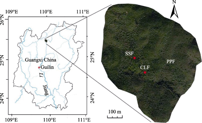
Fig. 1 Location of the study area and soil moisture measuring sites
The objective of this study is to examine the effects of different forest types on soil moisture and annual changes in moisture in different soil layers. The results of the study contribute to the understanding of the relationships between forest types and soil moisture and give useful information for land use planning in the upper reaches of Lijiang River basin. Based on continuous in situ observations of soil moisture dynamics in three typical forests, we aimed to 1) compare the vertical differences of soil properties among three typical forests; 2) understand the temporal and spatial variations of soil moisture under three forest cover conditions; and 3) determine the main factors of soil moisture responses to rainfall and soil characteristics.

2 Study area and methods

2.1 Study area

The study was conducted in the Mao’er Mountain (110°20°- 110°35°E, 25°48°-25°58°N) (Fig. 1) area in the upper reaches of the Lijiang River basin, southern China. The source of the Lijiang River is in the Mao’er Mountain area with a mean elevation of 2100 m. This area has a subtropical monsoon climate affected by winter monsoon or westerly circulation transporting continental air masses and warm moist air from the western Pacific Ocean. Mean annual temperature is 7 ℃, and the highest air temperature is 23 ℃ in June and the lowest air temperature is -19 ℃ in January. Mean annual precipitation is 2100 mm, with approximately 76% of annual precipitation falling from the months of March to August. The majority of rainfall events are short and low intensity. Forest coverage is 96.5% and the dominant forests are bamboo forest, evergreen broadleaf forest, evergreen coniferous and broadleaf mixed forest, evergreen deciduous and broadleaf mixed forest, evergreen coniferous and broadleaf mixed forest, alpine forest and alpine meadow from low elevation to high elevation.

2.2 Methods

2.2.1 Experiment design
We selected three typical forests with tree layers composed mainly of P. pubescens forest (PPF), S. superba forest (SSF) and C. lanceolate forest (CLF). We established two plots in each forest type. Each plot was a plastic board-sided box 20 m long, 10 m wide, and 1 m deep, with a laterally continuous reinforced plastic pipe on the side and bottom to flux soil water. In mountainous regions, topography is a dominant factor in the deep soil layer when lateral water flux shapes the spatial distribution of soil moisture (Brocca et al., 2009). All of experimental plots in this study were, therefore, located on slopes with this characteristic. Variations of forest vertical structure and soil properties of different plots seemed to play a major role in influencing the spatial pattern of soil moisture. Basic information of the three typical forests is shown in Table 1.
Table 1 Forest characteristics for soil moisture in three typical forests
Forest type PPF SSF CLF
Elevation (m) 680 700 710
Slope aspect SW SW W
Slope (°) 35 32 37
Canopy density (%) 90 85 95
Density (trees ha-1) 2250 1200 320
DBH (cm) 8.3 18.4 19.3
Average height (m) 10 7.5 15
Soil types Mountain yellow earths
2.2.2 Soil sampling and analysis
Three soil sampling points were designated by drawing an ‘S’ shape within each plot. Undisturbed soil samples were collected from three depths at each point in each plot. A soil auger was used to sample soils from 0-20, 20-50 and 50-80 cm layers in August 2013. Soil characteristics of the samples were measured in a laboratory using routine methods. Soil bulk density was estimated using a standard method (ISSCAS, 1978; Blake and Hartge, 1986). Total porosity and capillary porosity were determined by a method of ISSCAS (1978) and Liu et al. (2009). Non-capillary porosity was obtained by calculating the difference between total porosity and capillary porosity. Soil infiltration capacity was investigated using the double ring method (Ma et al., 2006). Litterfall within one-meter square in the plots were collected into plastic bags, transported to the laboratory and dried naturally. After drying, maximum water holding capacity was determined by wetting the material to saturation and then comparing difference in weight before and after wetting (Wohlfahrt et al., 2006).
2.2.3 Soil moisture testing and data collection
An Environmental Integration System was installed at each observation site to monitor climatic conditions at 5-min intervals, including air temperature, relative humidity, and precipitation during the study period (He et al., 2012). The probes for a soil moisture observation system (SMR101A-5, MadgeTech, America) were buried in the soil at desired depths with a cable extending to the surface to record soil moisture, soil temperature, maximum and minimum temperature in soil layers at 0-20, 20-50 and 50-80 cm at 5-min sampling intervals from 11 June 2013 to 15 October 2014.
2.2.4 Statistical analysis
The variances in soil moisture and soil properties between different soil layers and forest types were compared by one-way ANOVA, LSD’s test, and t test. The correlation between soil moisture and soil characteristics was analyzed by Spearman correlation analysis. All statistical analyses were conducted using SPSS 16.0 software (SPSS Inc., Windows ver. 16.0).

3 Results

3.1 Characteristics of soil layers in three typical forests

Table 2 summarizes the key physical properties from litterfall layer to deep layer, including litterfall, maximum water holding capacity of litterfall, soil bulk density, cap-illary porosity, non-capillary porosity, total porosity, initial infiltration rate, and steady infiltration rate. Many of these properties differed significantly among the three forest types. Litterfall differed with the mean values of 11.21 t ha-1,14.73 t ha-1, and 13.49 t ha-1 for PPF, SSF and CLF, respec-tively. Litterfall in SSF was significantly higher than that in PPF and CLF; therefore, maximum water holding capacity of litterfall in SSF (32.8 t ha-1) was significantly greater than in PPF (13.8 t ha-1) and CLF (25.7 t ha-1) (Table 2).Bulk density and porosity are important parameters reflect-ing permeability of water and the extension of plant roots (Zheng et al. 1998). The soil bulk density varied significantly in both soil layers and forest types. Soil bulk density increased with increasing soil depth (Table 2). From top layer (0-20 cm) to deep layer (50-80 cm), the soil bulk density increased from 0.85 g cm-3 to 1.09 g cm-3, 0.74 g cm-3 to 0.88 g cm-3, and 0.79 g cm-3 to 0.92 g cm-3 in PPF, SSF and CLF, respectively. Soil total porosity is composed of soil capillary porosity and soil non-capillary porosity. Soil porosity reflects the permeability of air and water, as well as the limit of plant root growth (Liu and Huang 2005). Results of the present study (Table 2) showed significant differences in soil porosity between soil layers in three typical forests. With increasing depth in the soil, the highest values of soil total porosity were observed at 0-20 cm soil layer, 0-20 cm soil layer and 20-50 cm soil layer for PPF, SSF and CLF, respectively. Total porosity in 0-20 cm soil layer was significantly higher in SSF (62.4%) than it was in PPF (57.70%) and CLF (50.21%). Infiltration features reflect the ability of soil to transform surface runoff into interflow or groundwater runoff and obviously affect soil moisture and water conservation (Wu et al. 2004). Results of this study showed no significant difference in the saturated permeability of soil upper and lower strata between the three different forests (Table 2). Most of the initial infiltration rate decreased with increasing depth in the soil, except for PPF, which increased slightly in 50-80 cm soil layer (Table 2).
Table 2 Litterfall and soil physical properties of different layers in three typical forests
Forest type PPF SSF CLF
Litter
layer
Litterfall (t ha-1) 11.21 14.73 13.49
Maximum water holding
capacity (t ha-1)
13.8 32.8 25.7
0-20 cm
soil layer
Soil bulk density (g cm-3) 0.85 0.74 0.79
Capillary porosity (%) 12.74 16.92 10.48
Noncapillary porosity (%) 44.96 45.48 39.73
Total porosity (%) 57.70 62.40 50.21
Initial infiltration rate (mm/min) 6.20 5.85 6.41
Steady infiltration rate (mm/min) 0.70 0.23 0.54
20-50 cm
soil layer
Soil bulk density (g cm-3) 1.02 0.93 0.78
Capillary porosity (%) 9.14 12.78 5.84
Non-capillary porosity (%) 43.54 44.75 50.88
Total porosity (%) 52.68 57.53 56.71
Initial infiltration rate (mm/min) 5.42 5.48 6.38
Steady infiltration rate (mm/min) 0.16 0.18 0.48
50-80 cm
soil layer
Soil bulk density (g cm-3) 1.09 0.88 0.92
Capillary porosity (%) 3.38 17.79 11.22
Noncapillary porosity (%) 49.78 39.89 44.93
Total porosity (%) 53.16 57.68 56.15
Initial infiltration rate (mm/min) 5.48 5.42 5.99
Steady infiltration rate (mm/min) 0.27 0.15 0.55

3.2 Monthly variation of soil moisture in three typical forests

Soil moisture in 0-20 cm, 20-50 cm and 50-80 cm layerswas monitored and analyzed in three typical forests. Theresults showed that soil moisture properties varied with periods (Fig. 2). During the study period, soil moisture in PPF ranged from 38.01 to 41.19%, from 39.04 to 42.78% and from 38.26 to 50.07% in 0-20 cm soil layer, 20-50 cm soil layer and 50-80 cm soil layer, respectively, from 47.55 to 53.84%, from 41.08 to 49.37% and from 42.42 to 48.39% in SSF, and from 35.01 to 38.61%, from 30.61 to 33.97% and from 27.60 to 34.51% in CLF. As expected, the three typical forests had the same change trends in response to rainfall. Soil moisture variations responded well to rainfall and most of the high values for soil moisture emerged in March, April or May during the year of observations. Soil moisture peaked in rainy seasons and then decreased in dry seasons. Although the precipitation was lowest in June, soil moisture was not lowest because soils retained the water obtained during rainy seasons (Fig. 2). The highest values in PPF were 40.33%, 29.29% and 25.95% in 0-20 cm layer, 20-50 cm layer and 50-80 cm layer, respectively, 39.34%, 25.50% and 22.58% in SSF, respectively, and 39.34%, 25.50% and 22.58% in CLF, respectively.
Fig. 2 Monthly variations of soil moisture in three typical forests

3.3 Vertical comparison of soil moisture in three typical forests

Vertical variations of mean monthly soil moisture at 0-20 cm, 20-50 cm and 50-80 cm depths over one-year observation period are presented in Table 3. The results show that soil moisture varied with forest types and soil layers. Soil moisture was lowest (39.71%) at 0-20 cm, and increased to 41.06% at 20-50 cm and to 42.97% at 50-80 cm in PPF, suggesting that soil moisture was mainly sourced from the precipitation infiltration. However, similar patterns were not observed in the other two forest types, SSF and CLF. The high value of soil moisture in SSF was 50.53% at 0-20 cm and the lowest value (43.70%) was found at 20-50 cm, while in CLF the highest value was 36.75% at 0-20 cm and the lowest value was 31.47% at 50-80 cm. The difference of soil moistures at 0-20 cm, 20-50 cm and 50-80 cm depths among three different structures of forest were significant, not only at 0-20 cm (P < 0.01), but also at 20-50 cm (P < 0.01) and 50-80 cm (P < 0.01). In the 0-20 cm layer, the SSF had the highest soil moisture of 50.53%, followed by PPF (39.71%) and CLF (36.75 %) (Table 3).
Table 3 Vertical variations of soil moisture at different depths in three forests
Soil depth
(cm)
PPF SSF CLF Sig.
MEAN±SE max min MEAN±SE max min MEAN±SE max min
0-20 39.71(0.28) 41.19 38.01 50.53(0.58) 53.84 47.55 36.75(0.33) 38.61 35.01 P<0.01
20-50 41.06(0.34) 42.78 39.04 43.70(0.79) 49.37 41.08 32.04(0.23) 33.97 30.61 P<0.01
50-80 42.97(1.05) 50.07 38.26 46.27(0.57) 48.39 42.42 31.47(0.65) 34.51 27.60 P<0.01

Note: Data in brackets are standard errors of means (n=3).

3.4 Relationship between soil moisture, rainfall and soil properties

An analysis was carried out to understand how soil moisture varies with rainfall and soil properties (Tables 4 and 5). The monthly variations of soil moisture were closely related to variations of precipitation at the sites. A high positive correlation was found between precipitation and soil moisture, which proves that rainfall events play a critical role in raising soil moisture in three typical forests. Table 5 shows correlations among soil moisture and soil physical properties, which indicate that soil moisture was greatly affected by capillary porosity (R=0.983, P<0.05), non-capillary porosity (R=0.976, P<0.05), and total porosity (R=0.998, P<0.05). However, correlation analysis showed there was a negative relationship between soil moisture and initial infiltration rate (R=-0.985, P<0.05). Further analysis clearly showed that the soil initial infiltration rate had a positive correlation with non-capillary porosity (R=-0.946, P<0.05), which is consistent with the findings reported by Sharda and Ojaswi (2006). In addition, soil bulk density was significantly correlated with the litterfall (R=-0.983, P<0.05), implying that litterfall may be an important variable in controlling soil bulk density. However, no significant correlations between porosity and litterfall were observed in this study (Table 5).
Table 4 Correlation of soil moisture and monthly precipitation in three typical forests
Forest type Soil layer
(cm)
Correlation of soil moisture and monthly precipitation(R value)
Aug. Sep. Oct. Nov. Dec. Jan. Feb. Mar. Apr. May Jun. Jul.
PPF 0-20 0.152** 0.172** 0.184** 0.081** 0.131** 0.213** 0.093** 0.115** 0.381** 0.185** 0.07** 0.133**
20-50 0.028 0.312** 0.022 0.025* 0.296** 0.068** 0.201** 0.091** 0.178** 0.205** 0.083** 0.224**
50-80 0.106** 0.305** 0.120** 0.247** 0.193** 0.052** 0.280** 0.059** 0.012 0.063** 0.011 0.012
SSF 0-20 0.16** 0.341** 0.078** 0.042** 0.196** 0.120** 0.304** 0.139** 0.255** 0.076** 0.101** 0.117**
20-50 0.118** 0.240** 0.011 0.044** 0.130** 0.004 0.127** 0.01 0.319** 0.055** 0.043** 0.154**
50-80 0.061** 0.228** 0.044** 0.083** 0.071** 0.065** 0.248** 0.041** 0.048** 0.001 0.015 0.098**
CLF 0-20 0.083** 0.251** 0.095** 0.039** 0.130** 0. 19** 0.333** 0.499** 0.553** 0.257** 0. 05** 0.03**
20-50 0.218** 0.263** 0.038** 0.024** 0.003 0.03** 0.632** 0.125** 0.316** 0.097** 0.100** 0.06**
50-80 0.296** 0.198** 0.022 0.099** 0.245** 0.07** 0.250** 0.064** 0.042** 0.045** 0.100** 0.082**

Note: * means correlation significant at the 0.05 level; ** means correlation significant at the 0.01 level.

Table 5 The partial correlation matrix between soil moisture (%), litter stock (t ha-1), maximum water holding capacity of litter layer (t ha-1), soil bulk density (%), capillary porosity (%), non-capillary porosity (%), total porosity (%), initial infiltration rate (mm/min) and steady infiltration rate (mm/min).
` Litterfall Maximum water holding capacity Soil bulk density Capillary
porosity
Non-capillary porosity Total
porosity
Initial infiltration rate Steady infiltration rate Soil moisture
Litterfall 1.000
Maximum water
holding capacity
0.998* 1.000
Soil bulk density -0.983* -0.978* 1.000
Capillary porosity 0.862 0.874 -0.754 1.000
Non-capillary porosity 0.168 0.192 0.017 0.644 1.000
Total porosity 0.633 0.651 -0.479 0.938* 0.870 1.000
Initial infiltration rate -0.478 -0.499 0.307 -0.857 -0.946* -0.982* 1.000
Steady infiltration rate -0.939* -0.947* 0.859 -0.984* -0.497 -0.861 0.751 1.000
Soil moisture 0.623 0.642 -0.467 0.983* 0.976* 0.998* -0.985* -0.854 1.000

Note: * indicate significant at the 0.05 level.

4 Discussion

4.1 Relationships between forest type and soil properties

Soil moisture variation was found in different forest types and soil layers. It is well known that organic matter strongly affects the physical and chemical characteristics of topsoil (Zhang et al., 2010). Since litterfall in SSF was higher than it was in PPF and CLF, the 0-20 cm soil layer has higher organic matter content and soil moisture in SSF than in PPF and CLF (Table 2). Of all the forest stands, the lowest soil bulk density was observed in the SSF, followed by PPF and CLF, which demonstrates that broadleaf forests are more efficient than coniferous forests in improving soil physical properties (Ma et al., 2006). In general, organic matter content has significant positive correlation with total porosity, capillary porosity, and non-capillary porosity, and significant negative correlation with bulk density; these correlations were observed in our study (Table 5). Hu et al. (2003) reported that forest vegetation could improve forest soil porosity and water holding capacity, and enhance the moisture-retaining, infiltration and water conservation functions. Hudson (1994) also found that for each one percent increase in soil organic matter, the available water holding capacity in the soil increased by 3.7%. Similar results were found by Wang et al. (2008), who found that the topsoil layer under high vegetation cover, as with the highly organic fine-grained soils and litter layer, reduced thermal conductivity and increased water infiltration and water hold capacity. Thus, we can conclude that bulk density, capillary capacity and porosity are the key factors affecting the physical and chemical properties of soil. These factors have important functions improving the physical and chemical properties of soil as well as advancing the cycle of soil water in the forest ecosystem.
As mentioned above, changes in soil properties may significantly influence soil infiltration. Under similar climatic and topographic conditions, soil infiltration is mainly controlled by soil properties. Soil infiltration increases with increasing soil sand content, soil porosity and soil organic matter, and decreases with increasing soil bulk density, soil clay content and initial soil water content (Neris et al., 2012; Zhao et al., 2014). Furthermore, our results suggest that soil infiltration may be affected by root expansion. Plants modify soil structure mainly when their roots grow into dense soil layers, and the amount of extension, death and decomposition of plant roots can benefit soil melioration by increasing soil aggregate and improving the soil porosity condition. Plant roots play an important role in soil moisture redistribution (Neumann and Cardon, 2012). In this study, PPF is a shallow root species while SSF and CLF are deep-rooted species. The slightly higher moisture at 50-80 cm in three typical forests (Table 3) might be the result high porosity in SSF and CLF (Table 2), while it may be the result of high lateral flow within the soil layer in PPF. Unfortunately, because of the complexity of root systems in forest systems, the spatial heterogeneity of root biomass distribution was not determined in this study.

4.2 Relationships between soil moisture, precipitation and soil properties

Gaining a better understanding of the interactions between vegetation, soil and water flux is essential to environmental management for enhancing water yield in water-limited environments. Soil water is one of the most important factors controlling hydrological processes (Castillo et al., 2003; Seeger et al., 2004). However, soil moisture is influenced by vegetation structure and soil properties. Vertical structural factors such as tree rooting density and tree canopy can influence the spatial and temporal variability of soil moisture (Staelens et al., 2006; Dalsgaard, 2007). Forest soils tend to be relatively porous and accumulate more organic matter with high infiltration rates because trees loosen the soil. As presented in Table 3, the observation sites in each typical forest exhibited large variations in soil moisture both in space and depth. Significant correlations between soil moisture, precipitation and soil physical properties were observed in this study (Table 4 and 5). Soil moisture changed with rainfall, suggesting that soil moisture was mainly affected by precipitation (Table 4). We found significant Perrson’s correlations (P<0.01) between soil litterfall and soil properties, which confirmed that soil litterfall strongly controls soil properties, especially in the top soil (Zhang et al., 2010). This is supported by the observations reported by Venkatesh et al. (2010). Comparison showed that the soil moisture at 0-20 cm depth was higher in SSF than in PPF and CLF. A possible reason for this difference lies in the fact that the SSF site had very high organic matter content that improved the soil moisture of the soil (Zhao et al., 2006). In the deep layer, there were significant relationships between soil moisture and porosity and infiltration rate in the three typical forests, which was mostly because of the distribution of roots in the soil layers. Much of the soil moisture heterogeneity was resulted from variations in preferential water flow related to root distribution. Moreover, the generation of macrospores and channels by root penetration through soil tends to form preferential flow paths, thus enhancing soil moisture in deep soil (Li et al., 2011; Benegas et al., 2014). In brief, soil moisture was affected by various factors, including topography, precipitation, soil properties and vegetation. Many studies have pointed out that it is difficult to identify the relative contributions of vegetation, soil properties and topography to variations of soil moisture because of strong mutual and multiple influences among these influencing factors (Penna et al., 2009; Wang et al., 2012). All of these factors influence the spatial and temporal variability of preferential water flows in the soil, and on the other hand, bring significant variability in soil moisture regimes (Zheng et al., 2008).

5 Conclusions

The results of this study show that (1) Litterfall and soil physical properties differed significantly among the three typical forests. Infiltration capacity in SSF was more in favor of soil moisture than in PPF and CLF. (2) Strong variations were found in soil moisture at different forest stands and soil depths. Due to the complicated vertical structure of these stands, there were obvious differences in the trends of soil moisture from 0-20 cm soil layer to 50-80 cm soil layer. (3) Average soil moisture in each layer was higher in SSF than it was in PPF and CLF. (4) Soil moisture in different layers correlated closely with precipitation (P<0.01) and the three typical forests had the same change trends with respect to rainfall during the study period. (5) In the topsoil, soil moisture was influenced by soil properties which were mostly determined by litterfall, whereas in the deep soil, soil moisture was affected by variations of soil characteristics which were mostly determined by root distribution.

The authors have declared that no competing interests exist.

[1]
Aubert D, Loumagne C, Oudin L.2003. Sequential assimilation of soil moisture and stream flow data in a conceptual rainfall-runoff model.Journal of Hydrology, 280(1-4): 145-161.

[2]
Bell K R, Blanchard B J, Schmugge T J, et al.1980. Analysis of surface moisture variations within large field sites.Water Resources Research, 16(4): 796-810.

[3]
Benegas L, Ilstedt U, Roupsard O, et al.2014. Effects of trees on infiltrability and preferential flow in two contrasting agroecosystems in Central America.Agriculture, Ecosystems & Environment, 183: 185-196.

[4]
Blake G R, Hartge K N.1986. Bulk density.In: Klute B (ed). Methods of soil analysis. ASA & SSSA, Madison, 363-375.

[5]
Brocca L, Melone F, Moramarco T, et al.2009. Soil moisture temporal stability over experimental areas in Central Italy.Geoderma, 148(3-4): 364-374.

[6]
Castillo V M, Gómez-Plaza A, Martínez-Mena M.2003. The role of antecedent soil water content in the runoff response of semiarid catchments: a simulation approach.Journal of Hydrology, 284(1-4): 114-130.

[7]
Dalsgaard L.2007. Above and below ground gaps-the effects of a small canopy opening on throughfall, soil moisture and tree transpiration in Suserup Skov, Denmark.Ecological Bulletins, 52: 81-102.

[8]
Famiglietti J S, Rudnicki J W, Rodell M.1998. Variability in surface moisture content along a hillslope transect: Rattlesnake Hill, Texas.Journal of Hydrology, 210(1-4): 259-281.

[9]
Fu B, Chen L.2000. Agricultural landscape spatial pattern analysis in the semi-arid hill area of the Loess Plateau, China.Journal of Arid Environments, 44(3): 291-303.

[10]
Gwak Y S, Kim S H.2016. Factors affecting soil moisture spatial variability for a humid forest hillslope.Hydrological Processes, 31(2): 431-445.

[11]
He Z B, Zhao W Z, Liu H, et al.2012. The response of soil moisture to rainfall event size in subalpine grassland and meadows in a semi-arid mountain range: a case study in northwestern China’s Qilian Mountains.Journal of Hydrology, 420: 183-190.

[12]
Hu Z Y, Wang J X, Peng P H, et al.2003. Studies on soil amelioratin of the protection forests in the hilly areas of central Sichuan.Journal of Sichuan Forestry Science and Technology, 24(3): 17-24. (in Chinese)

[13]
Hudson B D.1994. Soil organic matter and available water capacity.Journal of Soil and Water Conservation, 49(2): 189-194.

[14]
ISSCAS(Institute of Soil Sciences, Chinese Academy of Sciences). 1978. Physical and chemical analysis methods of soils. Shanghai:.Shanghai Science Technology Press. (in Chinese)

[15]
Li X Y, Contreras S, Solé-Benet A, et al.2011. Controls of infiltration- runoff processes in Mediterranean karst rangelands in SE Spain.Catena, 86(2): 98-109.

[16]
Liu H Y, Huang J G.2005. Dynamics of soil properties under secondary succession forest communities in Mt. Jinyu.Chinese Journal Applied Ecology, 16(11): 2041-2046. (in Chinese)

[17]
Liu J, Ma D, Shi J.1999. A View of Harnessing Flood Disasters and Water Deficiency in Dry Seasons Along Li River.Carsologica Sinica, 18(2): 159-169. (in Chinese)

[18]
Liu X, Zhang G C, Heathman G C, et al.2009. Fractal features of soil particle-size distribution as affected by plant communities in the forested region of Mountain Yimeng, China.Geoderma, 154(1-2): 123-130.

[19]
Ma Z L, Gong Y B, Hu T X.2006. Characteristic of soil hydro-physical properties and water dynamics under different vegetation restoration types.Wuhan University Journal of Natural Sciences, 11(4): 1009-1014.

[20]
Mahmood R, Hubbard K G.2007. Relationship between soil moisture of near surface and multiple depths of the root zone under heterogeneous land uses and varying hydro climatic condition.Hydrological Processes, 21(25): 3449-3462.

[21]
Neris J, Jiménez C, Fuentes J, et al.2012. Vegetation and land-use effects on soil properties and water infiltration of Andisols inTenerife (Canary Islands, Spain).Catena, 98: 55-62.

[22]
Neumann R B, Cardon Z G.2012. The magnitude of hydraulic redistribution by plant roots: a review and synthesis of empirical and modeling studies.New Phytologist, 194: 337-352.

[23]
Penna D, Borga M, Norbiato D, et al.2009. Hillslope scale soil moisture variability in a steep alpine terrain.Journal of Hydrology, 364(3-4): 311-327.

[24]
Seeger M, Errea M P, Beguería S, et al.2004. Catchment soil moisture and rainfall characteristics as determinant factors for discharge/suspended sediment hysteretic loops in a small headwater catchment in the Spanish Pyrenees.Journal of Hydrology, 288(3-4): 299-311.

[25]
Sharda V N, Ojaswi P R.2006. Hydrological evaluation of forest tree covers in different agro-ecological regions of India. In: Proc. Int. Workshop on Impacts of Reforestation of Degraded Lands on Landscape hydrology in the Asian Region, Roorkee, India. 6-10 March: 1-18.

[26]
Staelens J A, De Schrijver A, Verheyen K, et al.2006. Spatial variability and temporal stability of throughfall water under a dominant beech (Fagus sylvatica L.) tree in relationship to canopy cover. Journal of Hydrology, 330(3-4): 651-662.

[27]
Sun F X, Lu Y H, Wang J L, et al.2015. Soil moisture dynamics of typical ecosystems in response to precipitation: a monitoring-based analysis of hydrological service in the Qilian Mountains.Catena, 129: 63-75.

[28]
Vereecken H, Huisman J A, Pachepsky Y, et al.2014. On the spatio-temporal dynamics of soil moisture at the field scale.Journal of Hydrology, 516: 76-96.

[29]
Venkatesh B, Lakshman N, Purandra B K, et al.2010. Analysis of observed soil moisture patterns under different land covers in Western Ghats, India.Journal of hydrology, 397(3-4): 281-294.

[30]
Venkatesh B, Nandagiri N, Purandara BK, et al.2011. Modelling soil moisture under different land covers in a sub-humid environment of Western Ghats, India.Journal of Earth System Science, 120(3): 387-398.

[31]
Wang G X, Li Y S, Hu H C, et al.2008. Synergistic effect of vegetation and air temperature changes on soil water content in alpine frost meadow soil in the permafrost region of Qinghai-Tibet.Hydrological Processes, 22(17): 3310-3320.

[32]
Wang G X, Liu G S, Li C J.2012. Effects of changes in alpine grassland vegetation cover on hillslope hydrological processes in a permafrost watershed. Journal of Hydrology, 444-445: 22-33.

[33]
Wilson D J, Western A W, Grayson R B.2005. A terrain and data based method for generating the spatial distribution of soil moisture.Advances in Water Resources, 28(1): 43-54.

[34]
Wohlfahrt G, Bianchi K, Cernusca A.2006. Leaf and stem maximum water storage capacity of herbaceous plants in a mountain meadow.Journal of Hydrology, 319(1-4): 383-390.

[35]
Wu Q X, Han B, Li Y Y.2004. Characteristics of soil infiltration in watersheds in Loess Hilly Region.Science of Soil &Water Conservation, 2(2): 1-5. (in Chinese)

[36]
Zhang C S, Xie G D, Fan S H, et al.2010. Variation in vegetation structure and soil properties, and the relation between understory plants and environmental variables under different phyllostachys pubescens forests in southeastern China.Environmental Management, 45(4): 779-792.

[37]
Zhang W G, An S Q, Xu Z, et al.2011. The impact of vegetation and soil on runoff regulation in headwater streams on the east Qinghai-Tibet Plateau, China.Catena, 87(2): 182-189.

[38]
Zhao H L, Yi X Y, Zhou R L, et al.2006. Wind erosion and sand accumulation effects on soil properties in Horqin Sandy Farmland, Inner Mongolia.Catena, 65(1): 71-79.

[39]
Zhao X N, Wu P T, Gao X D, et al.2014. Changes of soil hydraulic properties under early-stage natural vegetation recovering on the Loess Plateau of China.Catena, 113: 386-391.

[40]
Zheng Y S, Chen LG, Hong W.1998. Study on productivity and soil properties of mixed forests of Chinese fir and phyllostachys heterocycla cv. pubescens. Scientia Silvae Sinicae, 34(1): 16-25. (in Chinese)

[41]
Zheng H, Chen F L, Ouyang Z Y, et al.2008. Impacts of reforestation approaches on runoff control in the hilly red soil region of southern China.Journal of Hydrology, 356(1-2): 174-184.

[42]
Zimmermann B, Elsenbeer H.2008. Spatial and temporal variability of soil saturated hydraulic conductivity in gradients of disturbance.Journal of Hydrology, 361(1-2): 78-95.

Outlines

/