Desert Ecosystem

The Scientific Conceptual Framework for Ecological Quality of the Dryland Ecosystem: Concepts, Indicators, Monitoring and Assessment

  • WU Rina 1 ,
  • CONG Weiwei 2 ,
  • LI Yonghua 1 ,
  • LI Siyao 1 ,
  • WANG Dongfang 1 ,
  • JIA Zhiqing , 3, * ,
  • WANG Feng , 1, *
Expand
  • 1. Institute of Desertification Studies, Chinese Academy of Forestry, Beijing 100091, China
  • 2. College of Agronomy, Shenyang Agricultural University, Shenyang 110866, China
  • 3. Research Institute of Forestry New Technology, Chinese Academy of Forestry, Beijing 100091, China
*Corresponding author: JIA Zhiqing, E-mail: ; WANG Feng, E-mail:

Received date: 2018-11-30

  Accepted date: 2019-01-24

  Online published: 2019-03-30

Supported by

National Key Research and Development Program of China (2017YFC0503804)

Chinese Academy of Forestry Science Funds for Distinguished Young Scholar (CAFYBB2017QC007).

Copyright

All rights reserved

Abstract

The dryland ecosystem is the dominant component of the global terrestrial ecosystem since arid regions occupy 45% of the earth’s land area and feed 38% of the world's population. The stability and sustainable development of the dryland ecosystem are critical for achieving the millennium development goal (MDG) in the arid and semiarid areas. However, there is still no scientific guideline for measuring and conserving the health and productivity of dryland ecosystems. Therefore, the purpose of this study is to develop the scientific conceptual framework of defining, monitoring and evaluating the ecological quality of dryland ecosystems. The ecological quality of dryland ecosystems is represented by a system of comprehensive indicators that are each extracted from the ecological elements, and structural and functional indices of the ecosystem. These indicators can be monitored by integrating satellites and unmanned aerial vehicles with ground-based sensor networks at the scale of either observational sites or regional scales. Finally, the ecological quality can be evaluated by evaluation models based on the normalized index values and their thresholds. This paper presents a conceptual framework for monitoring and evaluating the ecological quality of drylands, which provides a way of advancing the monitoring, diagnosis, and evaluation of the ecological quality of the dryland ecosystems.

Cite this article

WU Rina , CONG Weiwei , LI Yonghua , LI Siyao , WANG Dongfang , JIA Zhiqing , WANG Feng . The Scientific Conceptual Framework for Ecological Quality of the Dryland Ecosystem: Concepts, Indicators, Monitoring and Assessment[J]. Journal of Resources and Ecology, 2019 , 10(2) : 196 -201 . DOI: 10.5814/j.issn.1674-764X.2019.02.010

1 Introduction

With the rapid development of the social economy and the continuing aggravation of climate change in China, the problem of ecosystem degradation has become increasingly prominent. To ensure the stability and sustainable development of the ecosystem, it is urgent to strengthen the ability of ecological monitoring to recognize the ecological quality and changing trends of ecosystems in China. Carrying out ecological quality monitoring is the basis for studying the changes in ecosystem functions, ecosystem restoration, biodiversity protection and ecological assessment under the influence of climate change and human activities. There is also a major strategic demand for implementing national- scale ecological environment monitoring, ensuring national ecological security and promoting the construction of ecological civilization.
Trans-scale and standardized networked observations are receiving increasingly attention in global change and ecosystem research. The National Ecosystem Observing Network (NEON), the European Integrated Greenhouse Gas Observing System (ICOS) and the Australian Terrestrial Ecosystem Research Network (TERN) are at the interna-tional forefront in the development of global ecosystem observation networks. Constantly enriching and updating the observational technologies, by emphasizing standardized network observation and strengthening the construction of observation systems from station to regional and even national scales, has become the developmental trend of international ecosystem observation and research networks (Novick et al, 2018; Teeri and Raven, 2002). Through the selection of industrial sector stations in China, the Ministry of Science and Technology led the establishment of the National Ecosystem Observation and Research Network in 2006 (Wang et al, 2015). However, there are significant differences in indicator systems, technical means and data specifications among the stations. There is also a lack of effective station-to-region integration of the observation technology. Therefore, it is urgent to develop multi-level and standardized integrated ecosystem monitoring standards and technical specifications to meet the scientific and technological needs of long-term ecological environmental monitoring and dynamic ecological quality assessment at the national level.
Dryland ecosystem is an ecosystem type that supports rare plant communities in an environment of sparse precipitation, strong evaporation and extreme drought. It is widely distributed throughout the whole biosphere and is an important subsystem of the terrestrial ecosystem (China Desert Ecosystem Functions and Research Team, 2017). It is also the regional space associated with national and regional ecological security. After years of development, China's long-term observation of dryland ecosystems has accumulated abundant data on ecological factors, ecological structure, function and biodiversity factors, but has directed only limited efforts toward research on multi-level and standardized comprehensive assessment of the dryland ecosystem. Following a long period of continuous over-exploitation and utilization, the dryland ecosystem has begun to suffer from structural destruction to functional disorder, resulting in regional shortages of water resources, wind erosion and desertification, and loss of biodiversity, all of which pose serious threats to social stability and ecological security in the arid areas of China (China Desert Ecosystem Functions and Research Team, 2017). Therefore, it is urgent and necessary to carry out ecological quality monitoring of dryland ecosystems by comprehensively applying scientific and technical methods to continuously monitor the components, structures and functions of dryland ecosystems at different scales, to obtain multi-level and high-precision information and to evaluate the quality status and changing trends of China’s dryland ecosystems.
In sum, this study aims to: 1) clarify the concept of ecological quality of dryland ecosystems; 2) determine the multiple indicators reflecting the ecological quality and establish the ecological quality indicator system for dryland ecosystems; 3) define the monitoring techniques and methods for each indicator in the indicator system; and 4) establish an assessment model for evaluating ecological quality to comprehensively evaluate the overall ecological quality of dryland ecosystems.

2 Dryland ecosystem observation and research network

With the rapid development of long-term observational stations and station networks for dryland ecosystems, the number of desert ecological stations in China will reach 47 by 2020, including 6 stations in hyper-arid areas, 9 stations in arid areas, 5 stations in semi-arid areas, 6 stations in sub-humid arid areas, 5 stations in alpine areas on the Qinghai-Tibet Plateau and 16 stations in other special environmental areas (Cui et al, 2017). Relying on the research network of dryland ecosystem positions in China, this research group has carried out the ecological quality monitoring of dryland ecosystems at Kumtag Station located in Dunhuang County in hyper-arid region, Dengkou Station in Bayannaoer in an arid region and Zhenglanqi Station of Duolun County in a semi-arid region.

3 Concepts

The dryland ecosystem is a biological community composed of xerophilic and super-xerophilic small trees, shrubs, subshrubs and dwarf subshrubs, as well as the animals and microorganisms that have adapted to it. It is also a dynamic system that allows for material circulation and energy flow together within its habitat. The dryland ecosystem habitat is characterized by sparse precipitation, a dry climate, abundant wind and sand, and sparse vegetation. The dryland ecosystem is the most fragile ecosystem in the land surface process and a representative ecosystem in the arid areas of northwest China, with a unique structure and function. Due to the continuous long-term over-exploitation and utilization of the dryland ecosystem, it has begun to develop structural destruction and functional disorder, resulting in regional shortages of water resources, wind erosion and desertification and the loss of biodiversity, which now pose serious threats to social stability and ecological security in the arid areas of China (China Desert Ecosystem Functions and Research Team, 2017).
Ecological quality refers to the comprehensive characteristics of the elements, structures and functions of the ecosystem within a certain space-time range. It is mainly reflected by the state, production capacity, structure and function stability, resilience to interference and ability of the ecosystem to recover from disruptions, and shows the advantages and disadvantages of the ecosystem's ability to maintain its nature, stability and self-organization. The ecological quality emphasizes the holistic consideration and quantitative scientific assessment of the structure and function of the ecosystem, and directly serves the restoration of the ecosystem, the protection of biodiversity and the establishment of ecological compensation mechanisms.

4 Monitoring indicator system

4.1 Objectives

In view of the current situation and existing problems of the dryland ecosystem observation and research network, a scientific, reasonable and instructive monitoring indicator system for the ecological quality of the dryland ecosystem is constructed. It is designed to provide guidance for the monitoring and assessment of ecological quality, protection and restoration of the ecological system, the management of the ecological system and other fields, to promote the optimization and upgrading of the existing ecological network, and to provide effective scientific support for national and regional ecological system protection, restoration and the optimization of management decisions.

4.2 Principles

According to the unique structure and function of the dryland ecosystem, we summarize the research results from the construction of relevant indicator systems at home and abroad, draw lessons from related international ecological system observation and research networks, and apply the following principles in the process of constructing the monitoring indicator system.
Be systematic. The indicator system basically covers the overall layout of ecological quality monitoring of dryland ecosystems. Monitoring indicators can be coordinated and unified to ensure the integrity of the monitoring indicator system and they can give full play to their roles.
Be practical. The construction of the indicator system follows the principles of unity, simplification and optimization, and also fully considers the unique structure and function of dryland ecosystems. The selected monitoring indicators are representative and targeted, and they can be applied to other dryland ecosystems (Cui et al, 2017).

4.3 Indicator system

By combing the research of relevant indicator systems constructed at home and abroad and targeted to the comprehensive monitoring and assessment of dryland ecosystems, an indicator system structure closely associated with the management of dryland ecosystems is established, and it is characterized by a sufficient scientific basis, advanced and feasible technology and clear logical relationships. The structure of the indicator system focuses on the basic features and changes in the macro-structure and service function of the ecosystem. Combined with the background characteristics and main problems of desert ecosystems in China as well as ecological conditions of different regions, the indicators with strong relevance which reflect the main characteristics of desert ecosystem are screened out by analyzing, comparing and integrating the indicator structure for monitoring the ecological quality of the dryland ecosystem. Thus, this system can realize the comprehensive monitoring and assessment of dryland ecosystems at different temporal and spatial scales.
According to the objectives and principles of the above- mentioned ecological quality monitoring indicators for dryland ecosystems, and combined with the background characteristics of dryland ecosystems in China, the monitoring indicator system for ecological quality of dryland ecosystems selects some indicators that can reflect the ecological quality of dryland ecosystems from either the regional scale or the station scale, respectively. As shown in Table 1, regional indicators include land use cover change, net primary productivity and soil organic carbon that represent the structure, function and soil conditions of the ecosystem, respectively. At the station scale, vegetation coverage was a highly responsive measure, reflecting land use dynamics that reveals changes in vegetative cover. Species number represents the extent of biodiversity at the local scale. The vegetation biomass reflects the quality of organic matter accumulated in a unit area at a given time. It can be used as the energy base and material source of desert ecosystem. Net primary productivity is the capacity of plants to capture and store solar energy through photosynthesis, which can represent the land productivity of the dryland ecosystem and it captures relatively fast changes in ecosystem function. On the other hand, soil organic carbon reflects slower changes resulting from the net effects of biomass growth and disturbance, and it is an indicator of resilience.
Table 1 Indicator system and method for monitoring the ecological quality of dryland ecosystem in a station area
Spatial
scale
Monitoring indicators Monitoring method
Region Land use cover change
Net primary productivity
Soil organic carbon
Satellite
Station Vegetation coverage
Species Number
Vegetation biomass
Net primary production
Soil organic carbon
Unmanned aerial vehicle monitoring
Unmanned aerial vehicle
Monitoring/Ground investigation
Ground sensor monitoring
Ground monitoring

5 Monitoring methods

With the rapid development of various space technologies, positioning observation technologies and computer technologies, ecological quality monitoring is able to adopt scientific, comparable and mature technical methods to monitor ecosystems at different scales and to obtain multi-level and high-precision information. Long-term spatial information of the dryland ecosystem is obtained by using top-down remote sensing technology, geographic information technology and model simulation technology, as well as bottom-up field observation, field investigation and humanistic empirical investigation (Table 1). Based on the ecosystem observation and research network, the data integration analysis is realized. Through multi-source data fusion, scale conversion and satellite-air-ground integration for mutual data verification, the quality status and changes of the ecosystem are assessed, providing important technical support for the protection and restoration of the regional ecosystem. The ecological quality monitoring of the dryland ecosystem includes both remote sensing monitoring and ground monitoring (Liu, 2016).

5.1 Remote sensing monitoring

5.1.1 High-altitude remote sensing monitoring
The monitoring of ecological quality by high-altitude remote sensing mainly uses information such as images and geographical positions collected by satellites at high altitudes to analyze the shape, structure and function of the ground cover. Satellite images typically contain multispectral and hyperspectral data. The image resolutions cover a wide range from tens of kilometers to 0.1 meters Thus, they can provide powerful data support for obtaining geomorphic and plant structural features at different scales, analyzing material and energy cycles in different ecosystems, and revealing biophysical processes at scales of individual plants, communities and ecosystems (Mu et al., 2018).
At present, continuous time series of satellite images with different resolutions have become important data sources for analyzing the structure, functional state and changes of the ecosystems. Through the interpretation of image data, long-term reliable dynamic data such as land use cover changes, net primary production, and soil organic carbon can be provided for ecological quality monitoring at the regional scale.
5.1.2 UAV and other low-altitude remote sensing monitoring
In the past 10 years, low-altitude UAV monitoring technology has been developing rapidly. Especially with the maturity of civilian light UAV technology, low-altitude UAV remote sensing has gradually become an important tool for ecological environment monitoring research. At present, light UAV can also carry ordinary RGB cameras in addition to multi-spectral, hyperspectral, lidar and other types of cameras. Image resolution can achieve centimeter-level (or even millimeter-level) accuracy, providing a more convenient, accurate and credible data source for ecological monitoring in arid areas and sparse vegetation areas (Han et al, 2018). For dryland ecosystems with few plants and a single habitat, the indicators monitored by UAV remote sensing include the vegetation coverage indicator, the species number indicator and the plant biomass indicator at the station scale through image interpretation (Musib et al., 2017).

5.2 Ground monitoring

There are three methods for obtaining ground monitoring data, namely automatic monitoring by ground sensors, semi-automatic monitoring by combining automatic collection with manual measurement records, and manual monitoring by relying completely on manual investigation and sampling analysis (Grainger, 2015). At present, ecological quality monitoring at the station scale mainly depends on artificial monitoring, including artificial vegetation monitoring with monitoring indicators such as the number of species indicator and the plant biomass indicator, and artificial soil monitoring with monitoring indicators such as the net primary production of plants and soil carbon content. Some of these indicators can realize semi-automatic monitoring, such as soil carbon storage, while others can support automatic monitoring and analysis, such as soil carbon storage and the net primary production of plants. However, for both automatic monitoring and semi-automatic monitoring, the data calculation model is derived from the simulation results of mass manual monitoring data (del Barrio et al, 2016).

6 Ecological quality assessment model

An assessment of ecosystem quality depends on the representative indicators for ecosystem vigor, organization, and resilience (Costanza, 1992). However, as each indicator can be quantified using different units, the values of each indicator need to be normalized. In order to avoid magnifying the indicators when they have different units, it is necessary to neutralize the order of magnitude:
${{M}_{i}}=({{m}_{i}}-{{m}_{\min }})/({{m}_{\max }}-{{m}_{\min }})$ (1)
Where mi is the value of the indicator datasets; and mmin and mmax refer to the minimum value and maximum value of the indicator datasets, respectively.
Both model indicators affect the assessed quality of the ecosystem and they describe different aspects of the ecosystem structure and features. The weights of these different aspects were set according to the Delphi method (Dalkey and Helmer, 1963) and the analytic hierarchy process (AHP) (Saaty, 1977). Firstly, the ecosystem quality indicators were decomposed into different hierarchy levels. Secondly, the correlations among the indicators were weighted based on the opinions of experts. Lastly, the judgment matrices were formulated and the importance of the sub-level indicators for the total indicator and the weights of the indicators were calculated (French et al., 1991). The formula used to calculate the total ecosystem quality is as follows:
$T{{Q}_{i}}=\sum\limits_{j=1}^{n}{{{\beta }_{ij}}{{M}_{ij}}}$ (2)
where TQi is the ecosystem quality score of the ith assessment unit; βij is the weight of the jth indicator of the ith unit; and Mij is the normalized value of the jth indicator of the ith unit. The ecosystem quality grades were classified by the TQ of both assessment units.
In this study, ecosystem quality is modeled at two scales: the regional scale and the station-scale when ecosystem quality was evaluated. The indicators in the model would correspond to the specified scales.

7 Conclusions

This study presents the scientific conceptual framework for monitoring and evaluating the ecological quality of the dryland ecosystem, which includes the concept of ecological quality, an indicator system, monitoring technologies and assessment models. The indicator system consists of 3 indices at the regional scale (land use cover change, net primary production and soil organic carbon) and 5 indices at the station scale (vegetation coverage, species number, plant biomass, net primary productivity of plants, soil carbon content). These indices can be monitored directly by satellite UAV, ground sensor networks and ground measurements at multiple sites. The comprehensive quality of the dryland ecosystem is evaluated by an assessment model that integrates the composite indicators and their weights. Integrated monitoring and assessment planning for ecological quality of dryland could become the tool for dryland ecosystem management to deliver multiple environmental and socio- economic objectives, including the pursuit of the Sustainable Development Goals in arid and semiarid area.
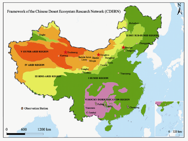
Fig. 1 Map of Chinese desert ecosystem research network

Acknowledgments

We especially thank professor Wang Shaoqiang and Lu Qi for their support and valuable contribution and discussions. We also gratefully thank professor Feng Yiming for the help on Fig. 1.

The authors have declared that no competing interests exist.

[1]
China Desert Ecosystem Functions and Research Team. 2017. Functions Assessment and Services Valuation of Desert Ecosystem in China, In: Li W H. ForewordⅠ. Beijing: Science Press. (in Chinese)

[2]
Costanza R.1992. Toward an Operational Definition of Ecosystem Health. In: Costanza R, Norton B G, Haskell, B D. Ecosystem Health: New Goals for Environmental Management. Washington DC: Island Press, 239-252.

[3]
Cui X H, Lu Q, Guo H, et al.2017. Construction of standard system for long-term observation of Chinese desert ecosystem.Journal of Desert Research, 37(6): 1121-1126. (in Chinese)

[4]
Dalkey N, Helmer O.1963. An experimental application of the Delphi method to the use of experts.Management Science, 9(3): 458-467.

[5]
del Barrio G, Sanjuan ME, Hirche A, et al.2016. Land degradation states and trends in the northwestern Maghreb Dryland, 1998-2008. Remote Sensing, 8: 603.

[6]
French S, Cooke R M, Vogt F.1991. The use of expert judgement in the context of a physical model. In: Bernardo J M, Berger J O, Dawid A P, Smith A F M. Bayesian Statistics. Oxford: Oxford University Press, 617-624.

[7]
Grainger A.2015. Is Land Degradation Neutrality feasible in dry areas?Journal of Arid Environment, 112: 14-24.

[8]
Han D, Wang H Z, Zheng B Y, et al.2018. Vegetation type classidication and fractional vegetation coverage estimation for an open elm (Ulmu pumila) woodland ecosystem during a growing season based on an unmanned aerial vehicle platform coupled with decision tree algorithms. Acta Ecologica Sinica, 38(18): 1-9. (in Chinese)

[9]
Liu J H, Shao Q, Yu X B, et al.2016. Comprehensive monitoring and assessment of China’s terrestrial ecosystem. Beijing: Science Press. (in Chinese)

[10]
Mu Y, Wang F, Zheng B Y, et al.2018. McGET: A rapid image-based method to determine the morphological characteristics of gravels on the Gobi desert surface.Geomorphology, 304: 89-98.

[11]
Musib M, Wang F, Tarselli M A, et al.2017. Artificial intelligence in research.Science, 357: 28-30.

[12]
Novick K A, Biederman J A, Desai A R, et al.2018. The Ameriflux network: A coalition of the willing.Agricultural and Forest Meteorology, 249: 444-456.

[13]
Saaty T L.1977. Erratum: “A scaling method for priorities in hierarchical structures”. Math. Psychol, 15(3): 234-281.

[14]
Teeri J A, Raven P H.2002. A national ecological observatory network.Science, 297(5586): 1445.

[15]
Wang S Q, Huang K, Yan H, et al.2015. Improving the light use efficiency model for simulating terrestrial vegetation gross primary production by the inclusion of diffuse radiation across ecosystems in China.Ecological Complexity, 23: 1-13.

Outlines

/