Preface

A National Key R&D Program: Technologies and Guidelines for Monitoring Ecological Quality of Terrestrial Ecosystems in China

  • WANG Shaoqiang 1, 2 ,
  • WANG Junbang , 1, * ,
  • ZHANG Leiming 1, 2 ,
  • XIAO Zhishu 3 ,
  • WANG Feng 4 ,
  • SUN Nan 5 ,
  • LI Daiqing 6 ,
  • CHEN Bin 1 ,
  • CHEN Jinghua 1, 2 ,
  • LI Yue 1, 2 ,
  • WANG Xiaobo 1, 2 ,
  • WANG Miaomiao 1, 2
Expand
  • 1. Key Laboratory of Ecosystem Network Observation and Modeling, Institute of Geographic Sciences and Natural Resources, Chinese Academy of Sciences, Beijing 100101, China
  • 2. College of Resources and Environment, University of Chinese Academy of Sciences, Beijing 100049, China
  • 3. State Key Laboratory of Integrated Management of Pest Insects and Rodents in Agriculture, Institute of Zoology, Chinese Academy of Sciences, Beijing 100101, China
  • 4. Institute of Desertification Studies, Chinese Academy of Forestry, Beijing 100091, China
  • 5. Key Laboratory of Crop Nutrition and Fertilization, Ministry of Agriculture/Institute of Agricultural Resources and Regional Planning, Chinese Academy of Agricultural Sciences, Beijing 100081, China
  • 6. State Environment Protection Key Laboratory of Regional Eco-process and Function Assessment, State Key Laboratory of Environmental Criteria and Risk Assessment, Chinese Research Academy of Environmental Sciences, Beijing 100012, China
*Corresponding author: WANG Junbang, E-mail:

Received date: 2018-11-21

  Accepted date: 2019-01-15

  Online published: 2019-03-30

Supported by

The National Key Basic Research and Development Program (2017YFC0503800)

Copyright

All rights reserved

Abstract

Ecological quality is defined as the stability, adaptability and resilience of an ecosystem. Monitoring and assessing ecological quality are important bases for China's ecological civilization construction. The national key research and development program “Technologies and guidelines for monitoring ecological quality of terrestrial ecosystems in China”, launched in July 2017, includes plans to study the observation technologies and provide guidelines on the ecological in-situ observation, the regional biodiversity and ecosystem function monitoring and its applications, all of which contribute to national ecological quality assessment. A year after its implementation, some important progress has been achieved, such as building the indicator system for comprehensive monitoring of ecological quality and improvement of the methods, mass data transmission, infrared camera-based monitoring of biodiversity, multi-angle automatic spectral observation systems, and unmanned aerial vehicle (UAV) based desert monitoring. We have organized this special issue and attempted to introduce the monitoring techniques and assessment methods on ecological quality from different perspectives in order to further promote the development of ecology and its observation methods.

Cite this article

WANG Shaoqiang , WANG Junbang , ZHANG Leiming , XIAO Zhishu , WANG Feng , SUN Nan , LI Daiqing , CHEN Bin , CHEN Jinghua , LI Yue , WANG Xiaobo , WANG Miaomiao . A National Key R&D Program: Technologies and Guidelines for Monitoring Ecological Quality of Terrestrial Ecosystems in China[J]. Journal of Resources and Ecology, 2019 , 10(2) : 105 -111 . DOI: 10.5814/j.issn.1674-764X.2019.02.001

1 Introduction

Ecological quality is the comprehensive sum of the characteristics of ecosystem elements, structures and functions within a certain time and space, embodying the status,production capacity, structural and functional stability, adaptability and resilience of ecosystems. The monitoring of ecological quality involves the comprehensive application of scientific, comparative and mature methods to monitor ecosystems on different scales and obtain multi-level and high-precision data, to evaluate the quality of the ecosystems and their changes (Sowin EN.Świerkosz, 2017). In recent years, ecological civilization construction and eco-logical environmental protection, as the core issues to ensure the rapid and healthy development of China’s economy, have been considered as high priorities in the national development strategy, and there is an urgent need to design the methods for multi-scale monitoring and scientific evaluation of China's ecological quality. Therefore, focusing on the national strategic requirements, we try to design the methods and guidelines that will serve to monitor and evaluate ecological quality and realize dynamic monitoring in various management scenarios on the national level.
Standardized technology systems for ecosystem observation provide an important basis for ecosystem network observation. National and regional ecological monitoring networks, represented by the National Ecological Observatory Network (NEON), Integrated Carbon Observation System (ICOS) and The Terrestrial Ecosystem Research Network (TERN), are at the forefront of standardized observation technology systems, and continue to improve with the development of observation technology and research topics (Novick et al., 2018; Teeri and Raven, 2002). The Chinese Ecosystem Research Network (CERN), established in 1988 by the Chinese Academy of Sciences, has achieved institutionalization and standardization of management after years of development (Committe, 2007; Yang et al., 2008; Yu et al., 2014). In 2006, the Ministry of Science and Technology set up the National Ecosystem Observing and Research Network through the selection of industry sector stations, and developed a series of technical guidelines or specifications. The emergence of new ground-based observation instruments, the development of terrestrial spectral networks, and the rapid development of unmanned aerial vehicle (UAV) and satellite remote sensing technologies (Wang et al., 2015) provide new opportunities for ecological quality monitoring and evaluation. Meanwhile, new requirements are being put forward for the observation standards and technical standardization of ecological factors, biodiversity and ecological functions (Lu, 2014; Wang et al., 2013; Wang, 2016; Yan et al., 2013).
There is an urgent need to build upon and improve the current monitoring technology systems and guidelines on ecological quality on the national level. In view of that need, the program that is based on the Chinese Ecosystem Research Network (CERN), the Terrestrial Ecosystem Research Network (TERN), the Soil Fertilizer Monitoring Network and the Biodiversity Observation Network, aims to build the monitoring indicator system and the technical guidelines for network observation on ecological environments, regional biodiversity and ecosystem functions. This program will also provide benchmarks for diagnosing the status and changes of ecosystems. As one of the tasks in the theme of key research and development on vulnerable ecosystems, the program has built a bridge between an upstream program on observational instrumentation and a downstream program on ecosystem assessment. It will vigorously promote the level of resource consolidation and capacity improvement to monitor and assess ecosystems and the environment in China, and will play an important role in the construction of national ecological security and its sustainable development.

2 Overview of the project

2.1 Project objectives

In order to promote the technology level of the network observation and information management on ecological environments, regional biodiversity and ecosystem function, this project has three main objectives. One is to scientifically analyze the effects of ecological environments, biodiversity and ecosystem functions on ecological quality and their relationships. Another is to diagnose the ecological quality of different ecosystems and to build the indicators and technical systems for monitoring ecological quality, through investigating the technology development trends of ecological network observation and the national demands for ecological civilization construction. Finally, the techniques and related guidelines will be suggested for ecological quality monitoring in different disciplines, through multi-level applications and validations in different ecosystems, to provide feasible high-precision methods to support monitoring of the dynamic changes of ecological quality of terrestrial ecosystems in China.

2.2 Proposed main tasks

Based on the present technology and guidelines on the ecosystem observation network, the project proposed to develop site-scale monitoring technology for the ecological environment, and regional-scale integrated monitoring technology for biodiversity and ecosystem functions. These technologies would then be applied to monitor regional and national ecosystem quality, and to explore and design forward-looking, collaborative and scientific monitoring technologies and guidelines, which mainly included the following 5 tasks which are diagrammed in Fig. 1.
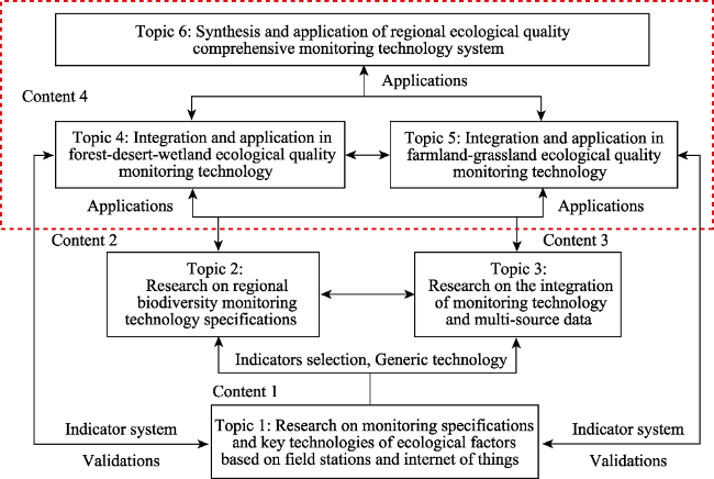
Fig. 1 Research contents and key topics proposed in this project
2.2.1 Technologies and guidelines for ecosystem network observation
To compare and analyze the indicators and technical systems of ecosystem network observation on biodiversity, ecosystem environments and functions; To develop short- duration measurement and in-situ monitoring technologies and ecological information technology applying the Internet of Things; and finally to propose the standardized methods and guidelines on ecosystem network observation in China.
2.2.2 Technologies and guidelines for regional biodiversity monitoring
To develop an intelligent management system for data collection from ground-based biodiversity monitoring; To establish a regional biodiversity monitoring technology system including the multiple levels of community, species, population and inter-species relationships. This task will build a biodiversity index system for regional ecological quality and propose technology guidelines for regional biodiversity monitoring in China.
2.2.3 Technologies and guidelines for regional ecosystem function monitoring
This task integrates in-situ monitoring from ecosystem network observation, multi-scale remote sensing inversion and ecosystem model simulation, aimed at regional ecological quality assessment. It will establish the monitoring technology guidelines for regional ecosystem functions, mainly including ecosystem regulating, supporting and maintaining functions, and will develop multi-source data fusion technology and produce ecosystem data products covering multiple regional scales and the nation.
2.2.4 Applications of technologies and guidelines in specific ecosystems
To comprehensively integrate monitoring indexes and technologies for ecological environment and ecosystem functions, and build multi-dimensional indicators and their thresholds for ecological quality. The integrated technology system will be applied in the different ecosystems, such as those related to topic 4 (forest, desert, and wetland), and topic 5 (farmland and grassland) in Fig. 1. The technology guidelines and standards will be proposed for ecosystem quality monitoring in forestry, agriculture and environmental management systems.
2.2.5 Synthesis of application of technologies and guidelines in key regions
The key monitoring indicators will be selected for comprehensive assessment of regional ecological quality and the monitoring techniques and guidelines will be integrated based on the above studies on biodiversity, ecological environment and ecosystem functions. The case studies will be conducted to comprehensively monitor ecological quality in the national key ecological function areas, and will revise the methods as the national standards and guidelines on the comprehensive monitoring of ecological quality as topic 6 in Fig. 1.

2.3 Proposed research methods

The proposed methods for this project are shown in Fig. 2, and they can be summarized as four key procedures.
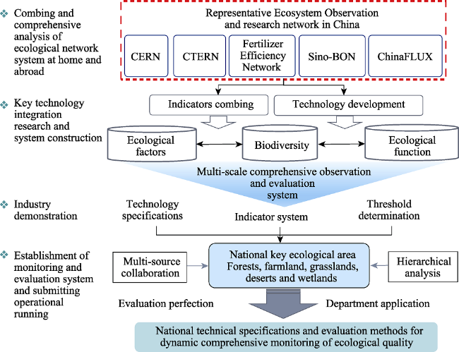
Fig. 2 The proposed framework for the research methods in this project
An indicator system for ecological quality will be built and threshold criteria for assessing ecological quality will be established by considering ecosystem functions for regulating, supporting, and maintaining the biodiversity of vegetation and animals, from field to regional scales, for the main ecosystems of forest, desert, wetland, grassland and cropland.
On the sites of the Chinese Ecosystem Research Network (CERN), the technologies on in-situ observations and the internet of things will be developed, validated and assessed. Then the comprehensive observation guidelines or standards will be proposed and recommended in the Chinese National Ecosystem Research Network (CNERN).
Multi-source data fusion based on in-situ monitoring, UAV observation, satellite based remote sensing, and ecosystem model simulation will be developed for the ecosystem functions of regulating, supporting, and maintaining the biodiversity of vegetation and animals on the regional scale.
The methods and their guidelines will be applied and assessed for their scientific validity, feasibility, and reliability in forest, desert, wetland, cropland and grassland settings.The specific sites for the case studies will include the 18 field stations and the 5 biodiversity monitoring base stations distributed among the 3 key ecological zones as shown in Fig. 3. These sites cover the typical ecosystems types in China, which ensures the spatial representation of the monitoring indicators and method systems.
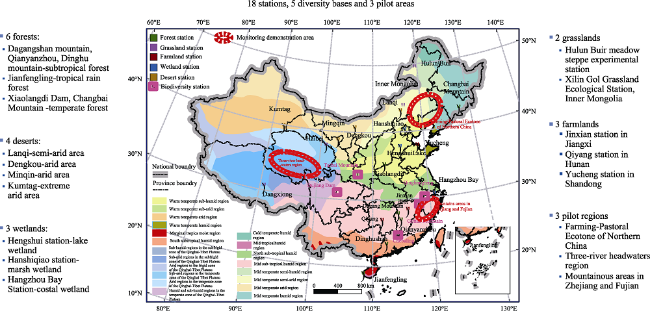
Fig. 3 Sites used for applications and validation of technologies and guidelines on ecosystem network observation of sites, biodiversity monitoring, and ecosystem functioning monitoring on the regional scale
Then the indicator system and monitoring technologies will be comprehensively optimized and applied to ecosystem quality assessment of some typical vulnerable areas and key ecological areas. Guidelines and standards of the methods system, as the final outputs of this project, will be proposed and recommended for application in ecological quality dynamic monitoring and comprehensive evaluation by the management departments of governments.

3 Research progress since the project started

3.1 Construction of a comprehensive monitoring indicator system for ecological quality

The extensive literature on the monitoring and evaluation of ecological quality have been collected and analyzed. The key indicators of ecological quality monitoring have been initially screened. Ecological indicators such as animal and plant diversity, and ecological functions, have been constructed according to the types of ecosystems involved. Nineteen evaluation indicators, including 55 monitoring items, were selected, and a regional ecosystem function monitoring indicator system was initially proposed.

3.2 Selection of Indicator System for the Ecosystem Observation Network

The preliminary program was drafted for the biology observation indicator system for Chinese terrestrial ecosystems at the site scale through the review and analysis of the present observation guidelines running on CERN, which were published in 2008. Based on the guidelines and standards on the environmental quality assessment suggested by the Ministry of Ecology and Environment, and the practice of ecological environment assessment on the county scale, the preliminary draft was completed for the biology monitoring indicator system for ecological quality assessment. We have developed a technology that dynamically monitors vegetation coverage (Song and Cao, 2017), and we are applying for a national utility model patent (Application number: ZL 2017 2 1500278.0) and have authorized a software copyright (Registration number: 2018SR274804). Based on the relaxation vorticity accumulation method, a technique was developed to observe the BVOCs flux released by plants, and its patent for a national utility model is in the application stage (Application number: ZL 2017 11 1362186.7). A technique was developed for the remote transmission of the mass data from the ecosystem network observations of on-ground, airborne and satellite remote sensing devices. The real time transmission of various data can be realized from the technical viewpoint if it is based on present facilities and the Internet, which means that the technology has been built to transmit observed data by a three-node mode from sites to stations and to the data center in Beijing (Wang et al., 2018b).

3.3 Applications of technical guidelines for comprehensively monitoring large- and medium-sized animals on land

Based on the technologies of infrared cameras, “3S” and multi-scale remote sensing, the technical guidelines were applied to comprehensively monitor large- and medium- sized animals on land at more than 70 sites in the nature reserves at Chebaling Guangdong, Gutianshan Zhejiang and Yangtze River Basin. A data management system for infrared camera pictures was built and more than 2 million pictures worth of data were obtained to record more than 100 species of mammals and 180 species of birds (Li et al., 2018a; Xiao et al., 2017). At the same time, the beta version of the intelligent management APP software (referred to as APP for the field survey) for the collection and submission of on-ground biodiversity monitoring data was finished.. It can be applied as the data acquisition terminals for ground surveying and monitoring of multiple species of organisms and use by nature reserves, scientific research units and the general public. The collected items of field investigation APP mainly include infrared camera surveys, animal sample line trace investigations, amphibian and reptile surveys, bird sample line spot surveys, rodent surveys, plant resource surveys, macrofungi surveys and insect sample line surveys. In the course of animal biodiversity monitoring in Chebaling National Reserve, Guangdong Province, since June 2017, the APP collection system has been tested many times, and the suggestions of front-line monitors have been incorporated to improve and update the APP.

3.4 Development and application of the vegetation canopy hyperspectral observation system

The multi-angle automatic spectral observation systems have been installed and debugged in Changbaishan, Dinghushan and Huairou. This remote network real-time monitoring of canopy spectral reflection of forest vegetation has laid a good technical foundation for the automatic observation of the vegetation canopy spectrum. At the same time, the development of the Vegetation Fluorescence System (SIFspec) was carried out. In December 2017 and April 2018, the Vegetation Fluorescence Systems at the Dinghushan Forest Station and the Hongyuan Wetland Station were completed. These systems use a prismatic spectroscopic system instead of a bifurcated fiber optic system, which solves the problem of spectral band drift and reduces the optical signal loss along the optical path (Qian et al., 2018; Wang et al., 2018a).

3.5 Technical integration and application in ecological quality monitoring in forest, desert and wetland

A new method based on unmanned aerial vehicle (UAV) and machine learning algorithms was developed to efficiently determine vegetation structure, coverage and Gobi gravel morphology in arid areas. The results have been published in the review journal Science (2017, 357:28-29) in the form of Letter, and in 2018 a paper on the algorithm research was published in Geomorphology, the core journal of international geomorphology. The software for the UAV High Precision Image Analysis Platform (https://www.uav-hirap. org) is based on this algorithm and it has one authorized software copyright (2017SR558256). It has also been tested and demonstrated at the core monitoring sites in forests, deserts and wetlands (Mu et al., 2017).

3.6 Technical integration and application demonstration for ecological quality monitoring in farmland and grassland

The evolution of characteristics of soil fertility and soil carbon sequestration efficiency have been researched based on long-term experiments. The coupling of nitrogen and water has been explored in typical temperate steppes. These studies have revealed the responses of soil respiration and temperature sensitivity to nitrogen fertilizer, the responses of typical grassland soil microbial communities to nitrogen application, and informed the guidelines for the typical grassland microbial community on soil carbon decomposition (Li et al., 2017; Li et al., 2018b; Ren et al., 2018; Ren et al., 2017; Wu et al., 2017).
A framework was developed to integrate and optimize satellite remote sensing, UAV, the sensor network, and the multi-site ground monitoring, and it was then applied to study cases in farmlands and grasslands. The platform and database were integrated and constructed to monitor ecological quality in farmland and grassland (Gao et al., 2018; Zhu et al., 2018).

3.7 Construction and application demonstration of a comprehensive monitoring technology system for regional ecological quality

An area of grassland degradation and desertification in the ecotone between agriculture and pasture in North China, the Weichang County, Hebei Province, covered mainly by forests and grasses, was selected as the case study area. The indicators for monitoring ecological quality on the regional scale were selected and the methods were applied and assessed, then the method guidelines were proposed. The changes in area of land covers and ecosystems were preliminarily analyzed and its ecological quality was assessed (Gong et al., 2017; Xu et al., 2018a; Xu et al., 2018b).

4 Summaries

Since this Program started in September 2017, we have obtained rich achievements through the construction of the observation index system and improvements and applications of the observation methods. Firstly, a comprehensive indicator system for ecological quality monitoring and assessing, including 19 indicators and 55 items, was constructed. Secondly, many new techniques were developed and applied. Examples include the remote transmission of the mass data from the ecosystem observation network of on-ground, airborne and satellite remote sensing systems, the infrared camera-based comprehensive monitoring of large and medium-sized animals, and the multi-angle automatic spectral observation systems and Vegetation Fluorescence System (SIFspec). Another major development was the new method of unmanned aerial vehicle (UAV) and machine learning algorithm developed to efficiently determine vegetation structure, coverage and Gobi gravel morphology in arid areas. Thirdly, the techniques developed were applied in desert, wetland, grassland, cropland and forest settings, and, especially, in key ecosystem areas to monitor and assess ecological quality, from which some technique guidelines were proposed for the monitoring and observing on the national scale.
Therefore, this special issue was organized on the theme of: “Technology and Evaluation Guidelines on Ecosystem Quality Monitoring”. It aims to introduce ecological quality monitoring and assessment methods from different perspectives. Among the included articles, Guo et al. analyzed the automatic measurement technology for greenhouse gases. Chen et al. analyzed the carbon sequestration function of straw return in farmland at the regional scale and Wang et al. quantified cropland quality and its occupation for urbanization in China from 2000 to 2015. Du et al., Li et al., and Xu et al. carried out application research in typical grasslands. Zhang et al. and Niu et al. discussed ecological quality assessment index systems in wetland and forest ecosystems. Wu Rina et al. reviewed the scientific framework frontier method for ecological quality index systems, monitoring technology and ecological evaluation methods in desert ecosystem. Wu Baiqiu et al. reviewed the cutting-edge methods in ecological evaluation.
In the process of national ecological civilization construction and the implementation of the beautiful China strategy, the national unified monitoring and objective scientific evaluation of ecological quality is not only the foundation, but also the source of the greatest difficulties and challenges. We hope to further inspire relevant research, enhance awareness and promote the development of ecology, resource science and the improvement of the observation methods through the publication of this series of papers.

The authors have declared that no competing interests exist.

[1]
Committe CERNS.2007. China Ecosystem Research Network (CERN) Long-Term Observation Specification Series. Beijing: China Environmental Science Press.

[2]
Gao M, Zhang X, Sun Z, et al.2018. Wheat yield and growing period in response to field warming in different climatic zones in China.Scientia Agricultura Sinica, 51(2): 386-400.

[3]
Gong X, Cao M, Sun X, et al.2017. Valuation of ecosystem services in Wuyishan City.Journal of Ecology and Rural Environment, 33(12): 1094-1101.

[4]
Li J, Xu H, Wan Y, et al.2018a. Progress in Construction of China Mammal Diversity Observation Network (China BON-Mammals).Journal of Ecology and Rural Environment, 34(1): 12-19.

[5]
Li Y, Liu Y, Wu S, et al.2017. Composition and carbon utilization of soil microbial communities subjected to long-term nitrogen fertilization in a temperate grassland in northern China.Applied Soil Ecology, 124: 252-261.

[6]
Li Y, Shi H, Zhou L, et al.2018b. Disentangling climate and LAI effects on seasonal variability in water use efficiency across terrestrial ecosystems in China. Journal of Geophysical Research: Biogeosciences, 123(8): 2429-2443.

[7]
Lu Q.2014. Desert ecosystem function assessment and service value research. Beijing: Science Press.

[8]
Mu Y, Wang F, Zheng B, et al.2017. McGET: A rapid image-based method to determine the morphological characteristics of gravels on the Gobi desert surface.Geomorphology, 304: 89-98.

[9]
Novick K A, Biederman J A, Desai A R, et al.2018. The AmeriFlux network: A coalition of the willing. Agricultural and Forest Meteorology, 249: 444-456.

[10]
Qian Z, Wang S, Chen J, et al.2018. Assessing canopy structure effect on the estimation of light-use efficiency in a subtropical evergreen forest.Journal of Natural Resources, 38(16): 5771-5781. (in Chinese)

[11]
Ren F, Zhang X, Liu J, et al.2018. A synthetic analysis of livestock manure substitution effects on organic carbon changes in China’s arable topsoil. CATENA, 171: 1-10.

[12]
Ren F, Zhang X, Liu J, et al.2017. A synthetic analysis of greenhouse gas emissions from manure amended agricultural soils in China.Scientific Reports, 7(1): 8123.

[13]
Song C, Cao M.2017. Relationships between Plant Species Richness and Terrain in Middle Sub-Tropical Eastern China.Forests, 8(9): 344.

[14]
Sowin EN.Świerkosz B.2017. Application of surrogate measures of ecological quality assessment: The introduction of the Indicator of Ecological Landscape Quality (IELQ). Ecological Indicators, 73: 224-234.

[15]
Teeri J A, Raven P H.2002. A National Ecological Observatory Network. Science, 298(5600): 1893-1893. https://doi.org/DOI10.1126/science.298.5600.1893.

[16]
Wang F, Pan X, Wang D, et al.2013. Combating desertification in China: Past, present and future.Land Use Policy, 31(2): 311-313.

[17]
Wang M, Wang S, Wang J.2018a. Detection of positive gross primary production extremes in terrestrial ecosystems of China during 1982- 2015 and analysis of climate contribution.JGR-Biogeosciences, 123(9): 2807-2823.

[18]
Wang S.2016.Carbon budget of terrestrial ecosystems in China based on remote sensing and model simulation. Beijing: Science Press.

[19]
Wang S, Huang K, Yan H, et al.2015. Improving the light use efficiency model for simulating terrestrial vegetation gross primary production by the inclusion of diffuse radiation across ecosystems in China.Ecological Complexity, 23: 1-13.

[20]
Wang Y, Jiang H, Wu M, et al.2018b. A distributed high efficiency similarity matrix computation method based on users’ mobile network access location.Telecommunications Science, 34(5): 26-38.

[21]
Wu S, Liu Y, Li Y, et al.2017. Effect of temperature and humidity on the alpine meadow soil carbon mineralization under different management in Naqu prefecture in Tibet. Journal of Beijing Normal University (Natural Science), 53(5): 615-623.

[22]
Xiao Z, Li X, Xiang Z, et al.2017. Overview of the Mammal Diversity Observation Network of Sino BON. Biodiversity Science, 25(3): 237-245.

[23]
Xu H, Cui P, Zhu X, et al.2018a. Progress in Construction of China Bird Diversity Obervation Network(China BON-Birds).Journal of Ecology and Rural Environment, 34(1): 1-11.

[24]
Xu H, Wu J, Wu Y, et al.2018b. Progress in Construction of China Amphibian Diversity Obervation Network(China BON- Amphibians).Journal of Ecology and Rural Environment, 34(1): 20-26.

[25]
Yan C, Stenseth N C, Krebs C J, et al.2013. Linking climate change to population cycles of hares and lynx.Global Change Biology, 19(11): 3263-3271.

[26]
Yang P, Yu X, Zhuang X, et al.2008. Current situation and future development of China Ecosystem Research Network (CERN) of Chinese Academy of Sciences.Bulletin of Chinese Academy of Sciences, 23(6): 555-561.

[27]
Yu G, Chen Z, Piao S, et al.2014. High carbon dioxide uptake by subtropical forest ecosystems in the East Asian monsoon region.Proceedings of the National Academy of Science, 111(13): 4910-4915.

[28]
Zhu W, Li S, Zhang X, et al.2018. Estimation of winter wheat yield using optimal vegetation indices from unmanned aerial vehicle remote sensing.Transactions of the Chinese Society of Agricultural Engineering, 34(11): 78-86.

Outlines

/