Orginal Article

Spatial Variation of Soil Inorganic Carbon Reserves of Typical Estuarine Wetlands in Jiaozhou Bay, China

  • SUI Xiaomin ,
  • PANG Mingyue ,
  • LI Yue ,
  • WANG Xiaotong ,
  • KONG Fanlong , * ,
  • XI Min , *
Expand
  • College of Environmental Science and Engineering, Qingdao University, Qingdao, Shandong 266071, China
*Corresponding author: KONG Fanlong, E-mail: ; XI Min, E-mail:

Received date: 2018-08-04

  Accepted date: 2018-11-01

  Online published: 2019-01-28

Supported by

National Natural Science Foundation of China (41771098)

Copyright

All rights reserved

Abstract

The storage of inorganic carbon in estuarine wetlands is of great significance for mitigating global warming. The Dagu River estuary and Yanghe River estuary of Jiaozhou Bay were selected as sampling areas, and data analysis was carried out by Duncan method to explore the distribution characteristics and influencing factors of soil inorganic carbon (SIC) reserves. The results showed that increasing distance from the estuary led to higher reserves in the mudflat along the coastal zone. The scouring action of seawater bodies was the main factor driving this distribution. In the vertical section, the SIC reserves in 40-60 cm depth were relatively high, accounting for 34.11% of the 0-60 cm soil depth, and resulting from the transport of water and salt in seawater. In the river flat along the vertical coastal zone, the SIC reserves first decreased and then increased with increasing distance from the sea, and the SIC reserves in 0-20 cm depth were relatively high in the vertical section, accounting for 38.18% of the 0-60 cm soil depth. These reserves were affected by synergetic factors such as oceanic factors and anthropogenic activities. The invasion of Spartina alterniflora decreased the SIC reserves of wetlands, mainly due to its root transformation and the differences of growth characteristics and years being the main reasons for the observed decreases. Aquaculture activities changed the physical and chemical properties of the soil in aquaculture ponds, and consequently changed the distribution of SIC reserves.

Cite this article

SUI Xiaomin , PANG Mingyue , LI Yue , WANG Xiaotong , KONG Fanlong , XI Min . Spatial Variation of Soil Inorganic Carbon Reserves of Typical Estuarine Wetlands in Jiaozhou Bay, China[J]. Journal of Resources and Ecology, 2019 , 10(1) : 86 -93 . DOI: 10.5814/j.issn.1674-764X.2019.01.011

1 Introduction

Wetlands, as a unique ecosystem formed by the interaction of water and land (Zhao et al., 2010), occupy only 4%-6% of the total land area globally (Kayranli et al., 2010), while wetland soil carbon storage accounts for 12%-20% of the total land carbon pool (Smith et al., 2004), and has attracted wide attention in carbon cycle studies. There are two main parts of wetland soil carbon reserves, namely, organic carbon reserves and inorganic carbon reserves. In recent years, extensive studies have been conducted on the total carbon reserves and organic carbon reserves of wetland soils including those focusing on their distribution characteristics (Owers et al., 2018), influencing factors (Daniel et al., 2017), and revenue and expenditure accounting (Delaune et al., 2018); whereas little attention has been paid to the soil inorganic carbon (SIC) reserves of wetlands, despite the fact that they also play an important role in carbon cycles. On one hand, wetland SIC has a higher accumulation rate than soil organic carbon (SOC); but on the other hand, it is characterized by a short cycle time and a high turnover rate. These two major advantages enhance its role in fostering the dynamic interactions with the atmosphere, plants and soil carbon pools in the long term (Wu et al., 2009). In addition, the dynamics of SIC reserves also have a significant impact on the carbon budgets of wetland ecosystems. Therefore, it is of significant importance to address the wetland soil inorganic carbon pools.
As an important part of wetlands, coastal wetlands have the highest carbon sequestration in the ecosystem, and play an essential role in the carbon cycle (Duan et al., 2008; Gao et al., 2017). Some previous studies on coastal wetland SIC have been carried out. Xu et al. (2009) studied the effect of different land use types on the SIC pool in the Yangtze River Delta. Tang et al. (2012) analyzed the spatial distribution of organic carbon and inorganic carbon in Jiuduansha wetland and the effect of salinity on carbon content. Maher et al. (2013) analyzed the relationship between dissolved inorganic carbon (DIC) and the missing carbon sink under tidal action in a mangrove tidal creek. Guo et al. (2015) explored the seasonal distribution of soil DIC and summarized the contribution of different factors to the control of DIC content. Wang et al. (2018) explored the distribution characteristics and influencing factors of soil DIC content in Jiaozhou Bay estuarine wetland. These studies focused more on the spatial and temporal characteristics of SIC and soil DIC and the comprehensive review of SIC pools. However, the comprehensive analysis of the spatial characteristics of SIC reserves is rarely reported. Therefore, further analysis is needed on the size of SIC pools with the unique geographical conditions of the region.
Estuaries are important parts of coastal wetlands, through which a large amount of inorganic carbon is transported into the coastal area by the river flows. This inorganic carbon influx is deposited in wetland soil together with the carbonate formed by unique hydrological processes in the region (Probst et al., 1994), resulting in an increased proportion of inorganic carbon to the total carbon. Statistical study of the SIC pool in the coastal area estuary wetland is thus of great significance to further improve the soil carbon cycle (Ouyang et al., 2013). In order to better understand the spatial and temporal characteristics of SIC reserves in coastal estuary wetlands, this study selected the coastal estuary wetland of the middle and lower reaches of Dagu River and Yanghe River in Jiaozhou Bay as the main study area. This area is located at the junction of the land and water, and is affected by the oceanic tidal process and the scouring of freshwater rivers that provide good conditions for soil carbon sequestration. Aquaculture activities are unique modes of land use in the mudflat. In addition, Spartina alterniflora is a typical alien invasive species in the estuary. The dual effects of land use and vegetation cover have enabled changes in the original soil properties and affected the reserves of SIC. This study used the comprehensive sampling of three directions (parallel coastal zone, vertical coastal zone, and vertical section) to quantify SIC reserves, analyze the distribution characteristics of SIC reserves, and explore the effects on SIC reserves of factors including the invasion of Spartina alterniflora and aquaculture activities, so as to provide a sound base for decision-makers to improve the accuracy of their carbon flux estimations in the coastal estuary wetland for future quantitative analyses.

2 Materials and methods

2.1 Study area

The Jiaozhou Bay (120º03°-120º25° E, 36º01°-36º15° N) is a semi-closed bay located in the central part of the Yellow Sea and on the south coast of the Jiaodong peninsula. The existing coastal wetlands along the coast are mainly distributed in the north and northwest of the peninsula, with a total area of 348 km2. It is the largest wetland along the estuarine bay in the Shandong Peninsula and has been included in the “national important wetland directory”. The coastal estuary wetland of Jiaozhou Bay and its vicinities are in the warm temperate continental monsoon climate zone, which is regulated by the ocean monsoon. The annual average temperature is 12.2°C, and the annual average rainfall is approximately 900 mm. The annual frost-free period is about 220 d. The tide is a typical semidiurnal tide with an average tidal range of 2.71 m and a maximum tidal range of 6.87 m. The flood tide duration is less than that of the ebb tide. Jiaozhou Bay is the mother bay of Qingdao, linking five main rivers including Dagu River, Jiaolai River, Yanghe River, Baisha River, and Ink River. The experimental area is the estuarine tidal flat wetland located in the middle and lower reaches of the Dagu River and the Yanghe River in Jiaozhou Bay. Among them, the Dagu estuarine tidal flat wetland is located in the middle and lower reaches of the Dagu River Basin, where the wide tidal flats, with fertile water quality and suitable salinity, have been developed into a typical aquaculture area (mainly including prawns and clams). The Yanghe River is a large river flowing into the Jiaozhou Bay, with a total length of 49 km and a basin area of 303 km2 (Xi et al., 2017). Since the introduction of Spartina alterniflora from abroad in 1979, a typical Spartina alterniflora marsh has formed in the Yanghe River estuary, and serves as a representative area for the study of alien species invasion.

2.2 Samples collection

According to the hydrogeological conditions and the distribution of vegetation in the Jiaozhou Bay, the field soil samples were collected in the study area in July 2016, and four representative wetland types, including mudflat, river flat, Spartina alterniflora marsh and aquaculture ponds (Fig.1), were selected to analyze the characteristics of SIC reserves distribution. Each wetland type was set up with a different number of sampling sites. Specifically, the first group of samples was collected from the mudflat along the coastal zone (No. 1-7); the second group was collected from the river flat along the vertical coastal zone (No. 8-14, with distances of 0, 0.3, 0.7, 1.1, 2, 2.8 and 3.5 km from the sea, respectively); the third group was collected at the Dagu estuary and the Yangkou estuary, including aquaculture ponds (No. 15-17), nearshore Spartina alterniflora marsh (No. 18), and the surrounding mudflat (No. 19), the far shore Spartina alterniflora marsh (No. 7, No. 7 is part of the first group of samples, but is also part of the Spartina alterniflora marsh), and the surrounding mudflat (No. 20). A total of 20 sample sites were selected in the three parts. Three parallel soil profiles at depths of 0-20 cm, 20-40 cm, and 40-60 cm at each sample site were collected. After air-drying, the parallel soil profiles were mixed with the same depth to represent the corresponding soil sample. All soil samples were placed in zip-lock bags immediately and transported to the laboratory. After drying at room temperature, the visible plant and animal residues were removed from the soil samples. Additionally, all soil samples were sieved, and then stored prior to the next processing step.
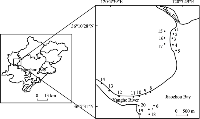
Fig. 1 Distribution of sampling sites in the Jiaozhou Bay

2.3 Chemical analysis

SIC includes HCO3- in soil solution, CO2 in the soil air, and CaCO3 deposited in soil, but CaCO3 is the dominant one present in large quantities. The content of CaCO3, salt content, and soil bulk density were determined according to the Methods of Soil Agricultural Chemical Analysis (Lu, 2000). The CaCO3 in the soil was measured through the gas volume method. The salt content was determined through the mass method. The soil bulk density was measured through the cutting ring method. All the samples were prepared as 1:5 soil:water ratio extracts.
SIC content is calculated by the following formula:
$\text{ }\!\!\omega\!\!\text{ }CaC{{O}_{3}}=\frac{\left( V-{{V}_{0}} \right)\times r\times 2.27}{m\times {{10} ^{6}}}\times 100\% (1)$
where V is the volume of carbon dioxide, mL; r is the density of carbon dioxide, g mL-1; 2.27 is the coefficient of mass conversion of carbon dioxide to calcium carbonate; and m is the weight of the soil sample, g.
The SIC reserves are calculated through the method of stratified cumulative summation calculation as follows:
$SIC=\sum\limits_{i=1}^{n}\, SI{{C}_{i}}\times {{D}_{i}}\times {{H}_{i}} (2)$
where SIC is the soil inorganic carbon reserves, kg m-2; i represents the soil of layer i; n is the number of soil layers; SICi is the soil inorganic carbon content of layer i, g kg-1; Di is the bulk density of layer i, g cm-3; and Hi is the thickness of layer i, cm.
The SIC reserves of the four representative wetland types are calculated based on formula (2). Descriptive statistics of SIC reserves in different types of wetlands are shown in Table 1.
Table 1 Statistics of SIC reserves in the different types of wetlands
Sampling site Maximum
(kg m-2)
Minimum
(kg m-2)
Mean
(kg m-2)
Standard
deviation
Variation
coefficient (%)
Kurtosis Skewness
Mudflat 0.8462 0.4792 0.6946 0.0971 13.97 0.0494 -0.6346
River flat 0.9288 0.4076 0.6691 0.1478 22.08 -0.9929 0.0520
Spartina alterniflora 0.6599 0.4193 0.5421 0.0944 17.41 -1.4547 0.0502
Aquaculture ponds 0.8751 0.6842 0.7911 0.0680 8.59 -0.9152 -0.6225

2.4 Data processing

Microsoft Excel 2010 was used to collate the experimental data, SPSS 17.0-Duncan analysis was used to test the difference of data between groups, and Origin 8 and CorelDRAW 12 were used to draw figures.

3 Results

3.1 Distribution characteristics of SIC reserves in the horizontal direction

3.1.1 Mudflat
The variation coefficient (CV) of SIC reserves in the mudflat is 13.97% (Table 1). The soil variability is divided according to the CV (Zi et al., 2016), and the variability of the mudflat is characterized as moderate variability. Therefore, the spatial distribution of SIC reserves in the mudflat is substantially different.
In the horizontal direction (Fig. 2), the differences of SIC reserves of the mudflat are significantly different. The SIC reserves of No. 1-5 sample sites in the Dagu river tidal flat wetland and No. 6-7 sample sites in the Yanghe River tidal flat wetland are all at the lowest values in the estuary, suggesting that the farther away from the estuary a site is, the larger its SIC reserves are. As for the distribution trend, the SIC reserves of Dagu River tidal flat wetland are larger than those of Yanghe River tidal flat wetland on the whole.
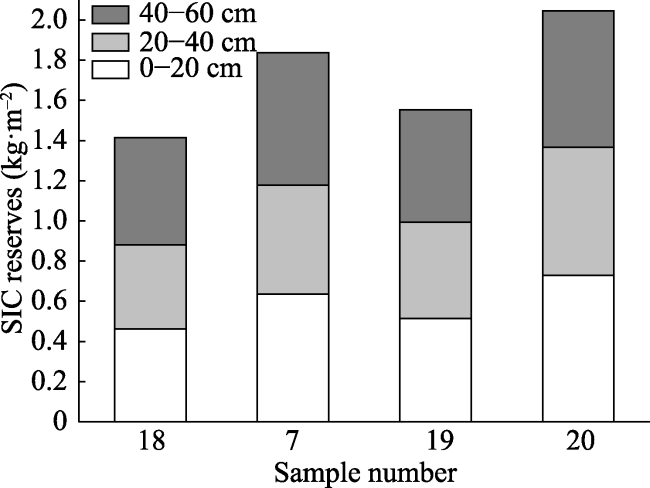
Fig. 2 Horizontal variation of SIC reserves in the mudflat
3.1.2 River flat
The variation coefficient of SIC reserves in the river flat is 22.08% (Table 1). According to the result of the division, the variability of the river flat is characterized as moderate variability. This suggests that the spatial distribution of SIC reserves in the river flat is quite different.
In the horizontal direction (Fig. 3), the SIC reserves of the river flat at different distances from the sea are not significantly different. The soil stored at the sea entrance (0 km from the sea) has the highest inorganic carbon. As the distance from the sea increases, the reserves of SIC decrease, and they achieve the minimum value at 0.7 km from the sea. Then at greater distances, the SIC reserves increase with the increase in distance from the sea and reach the second- highest value at the farthest distance from the sea (3.5 km).
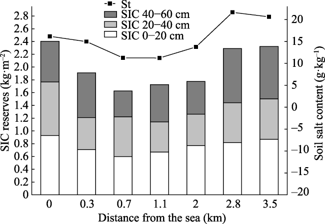
Fig. 3 Horizontal variation of SIC reserves and salt content (St) in the river flat
Note: 0 km is the critical point of the sea tide for submerging the soil during sampling.

3.2 Distribution characteristics of SIC reserves in the vertical sections

3.2.1 Mudflat
In the vertical section (Fig. 4), the difference of SIC reserves among different soil layers is not obvious, indicating that the SIC reserves are not closely related to the soil depth.
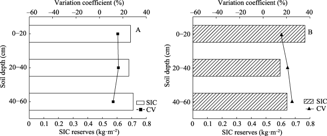
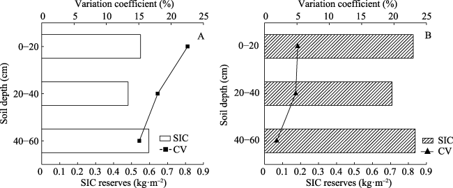
Fig. 4 Profile variation of SIC reserves in the mudflat (A) and river flat (B)
Note: CV is Variation coefficient
With the deepening of the soil layer, the SIC reserves of the mudflat first decrease and then increase. The SIC reserves in 0-20 cm, 20-40 cm and 40-60 cm depths account for 33.21%, 32.68% and 34.11% of the total SIC reserves in 0-60 cm, respectively, suggesting that the deep soil is the main place for SIC sequestration in the mudflat.
3.2.2 River flat
As was found for the mudflat, there is no significant difference in SIC reserves among different soil layers in the river flat (Fig. 4). The SIC reserves in 0-20 cm, 20-40 cm and 40-60 cm depths account for 38.18%, 29.73% and 32.09% of the total SIC reserves in 0-60 cm, respectively. Here, the SIC reserves in the surface soil are the highest.

3.3 The impacts of Spartina alterniflora invasion and aquaculture activities on SIC reserves

3.3.1 Spartina alterniflora marsh
The variation coefficient of SIC reserves in Spartina alterniflora marsh is 17.41%. According to the result of the division, it falls in the moderate variability category, representing the heterogeneous spatial distribution of SIC reserves.
In the horizontal direction (Fig. 5), the effect of species invasion on the SIC reserves of the wetland is analyzed by comparing SIC reserves between Spartina alterniflora marsh and the surrounding mudflat in the Yanghe River estuary. The SIC reserves of the Spartina alterniflora marsh and surrounding mudflat can be ranked as follows: the far shore mudflat > the far shore Spartina alterniflora marsh, and the near shore mudflat > the near shore Spartina alterniflora marsh. The overall distribution trend shows that the SIC reserves in the mudflat are larger than that in the Spartina alterniflora marsh, and the SIC reserves of both of them are significantly affected by the distance from the sea.
In the vertical section (Fig. 6), the SIC reserves in 0-20 cm, 20-40 cm and 40-60 cm depths account for 33.81%, 29.53% and 36.66% of the total SIC reserves in 0-60 cm, respectively. The deep soil is the main area for SIC sequestration.
Fig. 5 Horizontal variation of SIC reserves in the Spartina alterniflora marsh and nearby mudflat
3.3.2 Aquaculture ponds
The variation coefficient of SIC reserves of aquaculture ponds is 8.59%, which falls in the range of weak variation. The SIC reserves in the aquaculture ponds have a small spatial distribution difference.
In the horizontal direction (Fig. 7), the SIC reserves of the aquaculture ponds and surrounding mudflat of Dagu River estuary are compared to analyze the effects of anthropogenic activities on the reserves of SIC. The results show that the SIC reserves in the aquaculture ponds are higher than the SIC reserves of the surrounding mudflat on the whole. In the vertical section (Fig. 6), the SIC reserves in 0-20 cm, 20-40 cm and 40-60 cm depths account for 34.81%, 29.87% and 35.31% of the total SIC reserves in 0-60 cm, respectively. More SIC is stored in surface soil and deep soil than in intermediate depth soil.
Fig. 6 Profile variation of SIC reserves in the Spartina alterniflora marsh (A) and aquaculture ponds (B)
CV: Variation coefficient
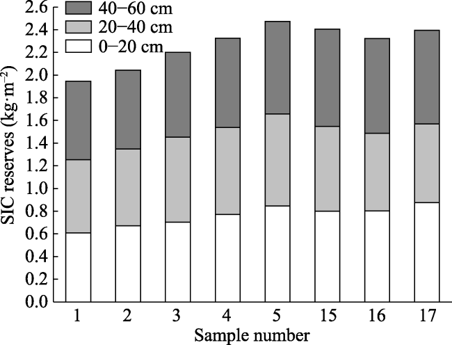
Fig. 7 Horizontal variation of SIC reserves in the aquaculture ponds and nearby mudflat

4 Discussion

4.1 Spatial distribution characteristics of SIC reserves in coastal wetland of Jiaozhou Bay

The mudflat and the river flat are both located in the delta region of the river flowing into the sea. It is a typical estuarine wetland which is formed by the interaction of sea and land, and it is strongly affected by the tidal effects of the ocean. The hydrologic process is thus an important factor for SIC reserves. As the media between inshore and coastal wetland ecosystems, tidal effects can contribute to transverse material migration and energy transformation between estuarine, wetland and coastal areas (Bauer et al., 2013). Under the effects of hydrological processes, the large water flow at the entrance to the sea and the strong scouring effects facilitate the reaction between CO2 in soil and seawater. As a result, the generated H2CO3 decreased the pH, causing the dissolution of CaCO3 and reduction of SIC (Yang et al., 2010). Moreover, suspended sediment will carry a significant amount of material during the tidal period, which will be deposited under flocculation. At distances farther away from the estuary, the flow velocity becomes smaller. Nevertheless, the strength of the water disturbance cannot resuspend the sediment in the flat surface, causing the accumulation of SIC, and this effect is the main factor leading to the variation of SIC reserves in the horizontal direction of the mudflat (Duan et al., 2008). In the vertical section, there is no vegetation cover in the light beach, and the interference intensity of the ocean tides is greater. This not only affects the lateral migration of the land and water, but also accelerates the deposition rate of the material. The Ca2+ of the soil surface is combined with the carbonated phase produced from the dissolved CO2 in the air or the decomposition of the plants and plant residues to form Ca(HCO3)2, which then moves downward by seawater leaching, and is deposited in the middle and lower soil profiles in the form of calcium deposits (Mi et al., 2008).
Salinity is an important ecological factor in the estuarine environment. It will directly or indirectly affect many physical, chemical, biological and biogeochemical processes. Frequent periodic seawater tides will cause changes in soil salinity (Liu et al., 2012). The carbon sequestration is achieved by affecting plant growth and vegetation growth structure in wetland ecosystems. Yu et al. (2015) confirmed that salinity is an important hydrochemical factor affecting inorganic carbon in surface sediments. Therefore, we measured the soil salt content of the 7 sampling sites of the river flat, and analyzed the relationship between the SIC reserves and the soil salt content. The results showed that both SIC reserves and soil salt content present similar distribution trends with distance from the sea on the whole. However, SIC reserves first increased and then decreased with the increase of soil salt content. This phenomenon indicates that the salt content below a certain critical value, the increase of salt content will provide the required ions for the formation of SIC, and above that value, it will affect the processes of respiration, digestion and decomposition of plants and microorganisms in the soil, thus reducing the activity of soil organisms and slowing down the process of organic matter to inorganic matter transformation in the soil, and inhibiting the production of carbonate (Setia et al., 2011; Li et al., 2017; Zhao et al., 2017). These trends are not only related to the dissolution of seawater in estuaries, but are also related to the mineralization phenomena caused by anthropogenic activities. Because of the factories, residential areas and other buildings located in the inland part of the region, the disturbances to wetland soil are obvious, leading to the increase of exogenous substances entering the surface soil, the acceleration of the deposition rate, and the deposition of SIC (Duan et al., 2008). In addition, studies have shown that inorganic carbon content in sediments is affected by different material sources, sedimentary environments, redox processes, and other factors. Moreover, the physical and chemical coagulation, such as the marine redox conditions, the organism metabolism and the physical and chemical agglomerates, also affect SIC reserves in offshore areas (Yates et al., 2006). Therefore, the changes of SIC reserves in the river flat reflect the effects of both hydrologic and anthropogenic factors on SIC migration, and have great complexity.

4.2 The effects of Spartina alterniflora invasion and aquaculture activities on SIC reserves

Spartina alterniflora is the most representative invasive species in Jiaozhou Bay. The mulching effect of plant leaves and the water conservation effect of roots can effectively reduce water evaporation, increase soil moisture content, and form an environment of soil anoxia (Tang et al., 2014). This anoxic environment can cause roots to be exposed to the surface, which weakens the flow velocity of the tidal water and deposits the carried SIC. Then plants transform the SIC into organic matter through photosynthesis, decreasing the reserves of SIC. The growth of vegetation is also an important factor affecting the carbon sequestration capacity (Bernal et al., 2012). Studies have found that short-term Spartina alterniflora invasion will decompose carbon pools for plant uptake and utilization (Yang et al., 2010), which results in low SIC reserves in the soil of nearshore Spartina alterniflora marshes. Through these processes, differences in plant growth characteristics and years can lead to variations in SIC reserves.
The planting of Spartina alterniflora can change soil structure and soil colloid state (Liu et al., 2011). The wetland soil transition layer is generally about 30 cm underground; and it is hard for the plant roots to penetrate into deeper soil where fewer roots can be found (Liu et al., 2003). Accordingly, the densely packed soil layer has low SIC reserves. In addition, the decomposition of SOC by Spartina alterniflora promoted the dissolution of inorganic carbon in surface soil, which caused SIC to move down with the increase of soil depth (Pan et al., 1997), and led to the low value of SIC in the upper and middle soil. In deep soil, organic matter decomposition and root and microbial respiration release a large amount of CO2. The CO2 interacts with soil water to form H2CO3 solution, which causes the precipitation of CaCO3 and resulting increase of SIC (Yang et al., 2010).
Aquaculture is one of the main anthropogenic activities in Jiaozhou Bay. In the process of sterilization and alkalization of aquaculture ponds, the large number of additives added into the ponds will increase the content of many different kinds of ions and nutrients in the soil and cause the salinization of the soil. This process leads to the increase in various forms of inorganic carbon, which is beneficial to the accumulation of SIC (Liu et al., 2015). Moreover, the algae resources in the aquaculture ponds are abundant, and their photosynthesis will change the physical and chemical properties of the water body, which is also one of the main factors that lead to the over saturation of calcium carbonate to produce carbonate precipitation (Obst et al., 2009). The complex and diverse management measures will affect soil SIC reserves as well. When the ponds are abandoned, the salt ions in the water accumulate on the surface of the soil under evaporation and increase the SIC reserves in the surface soil (Hren et al., 2012). Meanwhile, the biomass in aquaculture ponds is high. The decomposition activities of microorganisms can speed up the transformation of primary carbonate to secondary carbonate in surface soil, which also increases the surface SIC reserves. The leaching of water remains the main reason for the high SIC reserves in the deep soil. Additionally, related studies have shown that aquaculture activities will change the physical and chemical properties of soil in aquaculture ponds, resulting in low SIC solubility in deep sediments, which is beneficial to the retention of SIC in this layer (Quan et al., 2015).

5 Conclusions

In the horizontal direction, the SIC reserves of the mudflat are the lowest in the estuary. At increasing distances from the estuary, the reserves in the mudflat along the parallel coastal zone increase, suggesting the impact of tidal scouring action on SIC reserves at the estuary. The SIC reserves of the river flat first decrease and then increase with the increasing distance from the sea. Due to the different distances from the sea, SIC reserves are affected by synergetic factors such as the dissolution by seawater and anthropogenic activities. In the vertical section, more SIC is stored in the deep soil of mudflat due to the surface SIC replenishing to the deep soil under ocean tidal leaching. The SIC in the surface soil of the river flat is relatively high, indicating the effects of hydrologic and anthropogenic factors on SIC migration.
The invasion of Spartina alterniflora can decrease the SIC reserves of the wetland through the cover of leaves and the water retention of roots. The difference of plant growth and period is also an important factor affecting the low value of the SIC reserves. In addition, aquaculture activities have an impact on SIC reserves. The use of additives in aquaculture ponds and the biological effects of algae lead to the higher SIC reserves. The effects on ion concentrations caused by water evaporation, the decomposition activities of microorganisms and the leaching effect of seawater also comprehensively affect the vertical distribution of SIC reserves.

The authors have declared that no competing interests exist.

[1]
Bauer J E, Cai W J, Raymond P A, et al.2013. The changing carbon cycle of the coastal ocean.Nature, 504(7478): 61-70.

[2]
Bernal B, Mitsch W J.2012. Comparing carbon sequestration in temperate freshwater wetland communities.Global Change Biology, 18(5): 1636-1647.

[3]
Daniel D W, Smith L M, Mcmurry S T.2017. Effects of sediment removal and surrounding land use on carbon and nitrogen storage in playas and watersheds in the rainwater basin region of Nebraska.Soil and Tillage Research, 174: 169-176.

[4]
Delaune R D, White J R, Elsey-Quirk T, et al.2018. Differences in long-term vs short-term carbon and nitrogen sequestration in a coastal river delta wetland: implications for global budgets.Organic Geochemistry, 123: 67-73.

[5]
Duan X N, Wang X K, Lu F, et al.2008. Carbon sequestration and its potential by wetland ecosystems in China.Acta Ecologica Sinica, 28(2): 463-469. (in Chinese)

[6]
Gao M Y, Kong F L, Xi M, et al.2017. Effects of environmental conditions and aboveground biomass on CO2 budget in phragmites australis wetland of Jiaozhou Bay, China.Chinese Geographical Science, 27(4): 539-551.

[7]
Guo X S, Lv Y C, Sun Z G, et al.2015. Spatial-temporal distributions of dissolved Inorganic carbon and its affecting factors in the Yellow River estuary.Environmental Science, 36(2): 457-463. (in Chinese)

[8]
Hren M T, Sheldon N D.2012. Temporal variations in lake water temperature: Paleoenvironmental implications of lake carbonate δ18O and temperature records. Earth and Planetary Science Letters, 337-338: 77-84.

[9]
Kayranli B, Scholz M, Mustafa A, et al.2010. Carbon Storage and Fluxes within Freshwater Wetlands: a Critical Review.Wetlands, 30(1): 111-124.

[10]
Li Q F, Xi M, Wang Q G, et al.2017. Characterization of soil salinization in typical estuarine area of the Jiaozhou Bay, China.Physics and Chemistry of the Earth, Parts A/b/c, 103: 51-61.

[11]
Liu J S, Yang J S, Yu J B, et al.2003. Study on vertical distributon of soil organic carbon in wetlands Sanjiang Plain.Journal of Soil and Water Conservation, 17(3): 5-8. (in Chinese)

[12]
Liu L P, Long X H, Shao H B, et al.2015. Ameliorants improve saline-alkaline soils on a large scale in northern Jiangsu Province, China.Ecological Engineering, 81: 328-334.

[13]
Liu P P, Bai J H, Ding Q Y, et al.2012. Effects of water level and salinity on TN and TP contents in marsh soils of the Yellow River Delta, China.Clean-Soil Air Water, 40(10): 1118-1124.

[14]
Liu X D, Qiao Y N, Zhou G Y.2011. Controlling action of soil organic matter on soil moisture retention and its availability.Chinese Journal of Plant Ecology, 35(12): 1209-1218. (in Chinese)

[15]
Lu R K.2000. Methods of Soil Agricultural Chemical Analysis. China Agriculture Scientech Press. (In Chinese)

[16]
Maher D T, Santos I R, Golsby-Smith L, et al.2013. Groundwater-derived dissolved inorganic and organic carbon exports from a mangrove tidal creek: The missing mangrove carbon sink?Limnology and Oceanography, 58(2): 475-488.

[17]
Mi N, Wang S Q, Liu J Y, et al.2008. Soil inorganic carbon storage pattern in China.Global Change Biology, 14(10): 2380-2387.

[18]
Obst M, Wehrli B, Dittrich M.2009. CaCO3 nucleation by cyanobacteria: laboratory evidence for a passive, surface-induced mechanism.Geobiology, 7(3): 324-347.

[19]
Ouyang X G, Lee S Y.2013. Carbon accumulation rates in salt marsh sediments suggest high carbon storage capacity.Biogeosciences Discussions, 10(12): 19155-19188.

[20]
Owers C J, Rogers K, Woodroffe C D.2018. Spatial variation of above-ground carbon storage in temperate coastal wetlands.Estuarine Coastal and Shelf Science, 210: 55-67.

[21]
Pan G X, Tao Y X, Shun Y H, et al.1997. Some features of carbon cycling in humid subtr opical karst region: an ex ample of Guilin Yaji karst experiment site.Chinese Geographical Science, 7(3): 48-57.

[22]
Probst J L, Mortatti J, Tardy Y.1994. Carbon river fluxes and weathering CO2 consumption in the Congo and Amazon river basins. Applied Geochemistry, 9(1): 1-13.

[23]
Quan W, Ying M M, Kang H J, et al.2015. Spatial distribution of sediments carbon in Dongtou offshore aquaculture waters.Journal of Applied Oceanography, 34(4): 580-585. (in Chinese)

[24]
Setia R, Marschner P, Baldock J, et al.2011. Salinity effects on carbon mineralization in soils of varying texture.Soil Biology and Biochemistry, 43(9): 1908-1916.

[25]
Smith L C, Macdonald G M, Velichko A A, et al.2004. Siberian peatlands a net carbon sink and global methane source since the early Holocene.Science, 303(5656): 356-355.

[26]
Tang B, Long J P, Zhang W Yet al.2014. A review on the carbon sequestration capacity of coastal wetlands and its research progress in China.Marine Science Bulletin, 33(5): 481-490. (in Chinese)

[27]
Tang Y S, Wang L, Xi X F, et al.2012. The spatial distribution characteristics of organic and inorganic carbon content of intertidal water in Jiuduansha wetland.Journal of Agro-Environment Science, 31(12): 2459-2465. (in Chinese)

[28]
Wang X T, Kong F L, Xi M, et al.2018. Distribution characteristics of dissolved inorganic carbon in soil of typical estuarine wetlands in Jiaozhou Bay, China.Chinese Journal of Applied Ecology, 29(6): 2043-2050. (in Chinese)

[29]
Wu H B, Guo Z T, Gao Q O, et al.2009. Distribution of soil inorganic carbon storage and its changes due to agricultural land use activity in China.Agriculture Ecosystems and Environment, 129(4): 413-421.

[30]
Xi M, Zi Y Y, Wang Q G, et al.2017. Assessment of the content, structure, and source of soil dissolved organic matter in the coastal wetlands of Jiaozhou Bay, China. Physics and Chemistry of the Earth, Parts A/b/c, 103:35-44.

[31]
Xu N Z, Zhang T L, Wang X X, et al.2009. Statistical calculation of soil inorganic carbon stock in the Yangtze Delta region.Resources and Environment in the Yangtze Basin, 18(11): 1038-1044. (in Chinese)

[32]
Yang Y, Fang J, Ji C, et al.2010. Soil inorganic carbon stock in the Tibetan alpine grasslands. Global Biogeochemical Cycles, 24(4): GB4022, doi: 10.1029/2010GB003804.

[33]
Yates K K, Halley R B.2006. Diurnal variation in rates of calcification and carbonate sediment dissolution in Florida Bay.Estuaries and Coasts, 29(1): 24-39.

[34]
Yu Z T, Wang X J, Zhao C Y, et al.2015. Spatial variations of inorganic carbon and isotopes in the surface sediment of the Lake Bosten.Journal of Lake Sciences, 27(2): 250-257. (in Chinese)

[35]
Zhao Q Q, Bai J H, Lu Q Q, et al.2017. Effects of salinity on dynamics of soil carbon in degraded coastal wetlands: implications on wetland restoration.Physics and Chemistry of the Earth, Parts A/B/C, 97: 12-18.

[36]
Zhao W T, Liu B, Zhang Z H.2010. Water requirements of maize in the middle Heihe River basin, China.Agricultural Water Management, 97(2): 215-223.

[37]
Zi Y Y, Xi M, Kong F L, et al.2016. Temporal and spatial distribution of soil organic carbon and its storage in the coastal wetlands of Jiaozhou Bay, China.Chinese Journal of Applied Ecology, 27(7): 2075-2083. (in Chinese)

Outlines

/