Orginal Article

Transportation Accessibility of Central Towns in Important Agricultural Heritage Systems Sites in Mountainous Areas and Its Impact on Local Economic Development: A Case Study of Honghe Hani Rice Terraced System, Yunnan

  • ZHANG Yongxun 1 ,
  • LI Xiande 1 ,
  • MIN Qingwen , 2, 3, *
Expand
  • 1. Institute of Agricultural Economics and Development, Chinese Academy of Agricultural Sciences, Beijing 100081, China
  • 2. Institute of Geographic Sciences and Natural Resources Research, Chinese Academy of Sciences, Beijing 100101, China
  • 3. University of Chinese Academy of Sciences, Beijing 100049, China
*Corresponding author: MIN Qingwen, E-mail:

Received date: 2018-01-20

  Accepted date: 2018-05-30

  Online published: 2019-01-28

Supported by

The International Exchange and Cooperation Project of Ministry of Agriculture “Conservation of Globally Important Agricultural Heritage Systems (GIAHS) in China in 2018”

The Third-party Monitor and Assessment on Honghe Hani Rice Terraces Systems in 2018.

Copyright

All rights reserved

Abstract

Transportation as a means to support industrial development can impact the economic development of important agricultural heritage sites. Because the central towns in mountainous areas have weak economic interactions with each other, an appropriate method is needed to evaluate their transportation accessibility. This paper takes the Honghe Hani Rice Terraced System (HHRTS) as a study area and develops a model to determine shortest time-distances from central towns in the study area to the nearest high-grade city as a way to evaluate transportation accessibility (TA). We then analyze the relationship between the accessibility of these towns and their economies. The study finds that the TA of the central towns in HHRTS is not good as a whole. More than 70% of the towns are more than 1 hour away from their nearest high-grade city. Of the four counties in the study area, Yuanyang County has the best traffic conditions, while Lvchun County has the worst traffic conditions. The central towns in the northern and middle regions have better TA than those in the west, southwest and east margin regions. The small-scale rural economy has little dependence on the transportation network, while secondary industries are obviously impacted by the transportation network. In the future, to support the integrated development of industries in HHRTS, traffic conditions in each town should be improved appropriately according to the industrial orientation of the town, but excessive investments to construct roads irrespective of eco-environmental impacts and economic benefits should be avoided. Especially in the case of ecologically vulnerable towns, the building high-grade roads should be banned.

Cite this article

ZHANG Yongxun , LI Xiande , MIN Qingwen . Transportation Accessibility of Central Towns in Important Agricultural Heritage Systems Sites in Mountainous Areas and Its Impact on Local Economic Development: A Case Study of Honghe Hani Rice Terraced System, Yunnan[J]. Journal of Resources and Ecology, 2019 , 10(1) : 29 -38 . DOI: 10.5814/j.issn.1674-764X.2019.01.004

1 Introduction

In the 21st century, with globalization of the economy and high levels of informatization, interregional population migration and the exchange of goods and services have become the major forms of interregional trade. These are also the approach to promoting regional economic development. Transportation, as an important means of carrying migrating populations, moving cargo, and facilitating information exchanges, is a basis for developing regional industries. Transportation accessibility (TA) thus directly impacts the economic level of a region (Gulyás and Kovács, 2016; Wang et al., 2016a; Munnell, 1990). Generally, a region with low accessibility has a traditional agricultural system and agricultural culture still intact and has been little impacted by modern technologies and socio-culture. Because of this, Important Agricultural Heritage Systems (IAHS)11IAHS are usually taken to include the Globally Important Agricultural Heritage Systems (GIAHS) and Nationally Important Agricultural Heritage Systems (NIAHS). The GIAHS was launched by FAO in 2002 and by the end of 2016, 37 GIAHS in 16 countries had been designated by FAO. The first NIAHS was initiated by China in May 2012, and since then, South Korea began to grant their NIAHS designations in December 2012 and Japan in February 2016.) are usually distributed in those mountainous areas with low TA. Therefore, TA is an important concern that must be taken into consideration when planning agricultural heritage protection and development.
Because IAHS sites have poor infrastructure and traditional agriculture offers low returns, agricultural heritage systems are losing young people and becoming unsustainable. Using the resource advantages of IAHS sites to support regional economic development is widely seen as an effective strategy to protect the sites (Zhang et al., 2015; Wang et al., 2016b; Sun et al., 2011; Min et al., 2016; Qiu et al., 2014). To date, there have been many studies of industrial development at IAHS sites, including research on resource development and utilization patterns (Zhang et al., 2016; Tian et al., 2016), assessment of the developmental potential and capacity for tourism (Sun et al., 2011, Tian et al., 2015) as well as studies focused product development and branding of IAHS sites (Yiu, 2014). The infrastructure like TA needed to support industrial development, however, continues to get little attention from researchers.
Transportation is an extremely important aspect of IAHS conservation. It can exert multiple influences, either direct or indirect, on IAHS in areas like economic development, local culture and social structure (Shrestha et al., 2014). For example, poor traffic conditions restrict the development of resources in IAHS and hinder the release of regional economic potential (Sun et al., 2009). Finally, this results in population outmigration and farmland abandonment (Zhang et al., 2014; Ge et al., 2012). Population outmigration can make it difficult to sustain traditional agricultural systems and technologies, and socio-culture. Moreover, road network construction that is not part of a scientific planning effort may lead eventually to the destruction of an IAHS because of increasing pressure from modern culture and the over-development of new industries. As a result, it is very important that traffic links are based on scientific planning and address the needs both for socio-economic development and the protection of IAHS sites.
TA is defined as the degree of interaction opportunity between different nodes in a traffic network. It was first proposed as a quantitative index representing regional traffic conditions by Hansen in 1959 (Hansen, 1959). Many studies have shown that TA is able to accurately present a regional traffic network’s structure and evolution (Holl, 2007; Li et al., 2001) and that TA can have a significant influence on regional economic development and population change (Liu et al., 2008; Kotavaara et al., 2011). Therefore, TA is a valuable reference point for regional industrial arrangements and traffic planning. Currently, there are many methods of assessing TA. These can be classified into two categories. The first is to calculate the degree of traffic convenience of a place, including, for example, the density of road network, the sum of the shortest path from one place to other places in one area, and the average shortest path from one place to other places in one area (Wu et al. 2016). The second is to measure the probability that population or goods arrive at a place, including calculations of, for instance, weighted mean travel time (Gutiérrez, 2001) and minimization of travel cost (Meng and Yang, 2002.). However, these calculating measures are mainly used to evaluate the accessibility of cities in plain areas, but are inappropriate to assess the TA in the mountainous areas.
China has a great deal of mountainous and hilly territory. In these mountainous and hilly areas, road links between central towns and cities are poor due to rugged topography. In an area like Honghe Hani Rice Terraces System (HHRTS)2(2Honghe Hani Rice Terraces System was designated as a Globally Important Agricultural Heritage System (GIAHS) in 2009 by the Food and Agriculture Organization of the United Nations (FAO) and as a World Cultural Heritage (WCH) site by United Nations Educational, Scientific, and Cultural Organization (UNESCO) in 2013.) in the Yunnan-Kweichow Plateau in southwestern China, there are virtually no high-grade roads like superhighways or national highways between central towns because of high construction costs due to bad natural conditions and low population density. Narrow, winding and rough roads that severely limit vehicle speeds constitute the main part of the traffic network in these rural areas (Crossley, 1981). Besides, the economic connections between different towns are very low owing to the low income of farmers and lack of industries (Odoki et al., 2001). These features require to create a new methodology for evaluating the TA of central towns in the HHRTS sites.
This paper aims to explore an appropriate method to evaluate the TA of central towns of IAHS sites in mountainous areas. Local governments can depend on the results produced by this TA evaluation method to upgrade roads and arrange industries scientifically. Also, taking the central towns in HHRTS as objects, we evaluate their TA and analyze the relationship between their TA and their level of economic development to reveal the impact TA has on HHRTS. Finally, we provide some suggestions on industrial arrangements and transportation improvements for local governments.

2 Materials and methods

2.1 Study area and data sources

The study area is located in the southern section of Ailao Mountain on the south bank of the upstream area of the Yuanjiang River at 101°8°4"-103°39°4"E, 22°26°4"-23°27°4"N. It includes Honghe County, Yuanyang County, Lvchun County and Jinping County in Honghe Hani and Yi Autonomous Prefecture (Fig. 1). The four counties contain 49 central towns. The geomorphology of this area is very complex, comprised of mountains, valleys and rivers with almost no plains areas. The elevation of the study area is between 1000 and 2000 m and the terrain slopes from southeast to northwest. In this area, the highest elevation is the summit of Xilong Mountain at 3074 m and lowest elevation is the estuary of Longbo River at 105 m in Jinping County. The climate is a subtropical hilly monsoon type with obvious vertical changes in temperature and precipitation, with average temperatures in the four counties ranging from 18-25℃ and the annual precipitation gradually increasing from 700-900 mm along the Red River in the northern area to more than 2300 mm in the southern mountainous area. There are considerable seasonal differences in rainfall amounts from year to year. Generally, it is very dry in winter and spring and rainy in summer and autumn. Spring droughts are common disasters for this area.
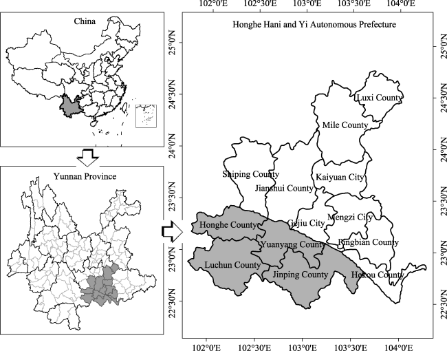
Fig. 1 Location of the study area
Honghe County, Yuanyang County, Lvchun County and Jinping County are areas with ethnic minority populations; the minority population in each county is above 87%. The Hani nationality is the largest ethnic group in the study area, followed by the Yi nationality, and then the Miao nationality and the Yao nationality. All four counties are agricultural counties and have been designated national-level poverty-stricken counties. The agricultural population comprises 91.1% (Honghe County), 87.8% (Yuanyang County), 91.5% (Lvchun County) and 90.2% (Jinping County) of total population in the four counties, and farmland area per capita is 0.051 ha (Honghe County), 0.063 ha (Yuanyang County), 0.055 ha (Lvchun County), 0.072 ha (Jinping County) in the four counties. The industrial structure of the four counties is as follows: Honghe County, agriculture 32.5%, secondary industries 29.9% and tertiary industries 37.5%; Yuanyang County, agriculture 32.2%, secondary industries 29.8% and tertiary industries 38%; Lvchun County, agriculture 32.8%, secondary industries 40.8% and tertiary industries 26.4%; and Jinping County agriculture 21.9%, secondary industries 50.4% and tertiary industries 27.7%.
In order to analyze the impact of TA on socio-economic conditions, we collected socio-economic indices and road data for each town in the HHRTS. The socio-economic indices for Gross Output Value of Agriculture Per Capita (GOVAPC) and Industrial Income Per Capita (IIPC) were for the year 2014 and were taken from the economic statistics bulletin of the four countries. The road data were obtained by analyzing vector maps using the network analysis function of ArcGIS software. The vector map data (Fig. 2) were based on an administrative map of Honghe County made in 2011, an administrative map of Yuanyang County made in 2014, an administrative map of Lvchun County made in 2013, and an administrative map of Jinping County made in 2012. The road data were also updated based on a digitial map from Baidu in May 2016. The DEM data were taken from the database of Institute of Geographic Sciences and Natural Resources Research, Chinese Academy of Sciences. The actual speeds of vehicles traveling on different grade roads were measured by the authors during visits to the study area in 2015 and 2016.
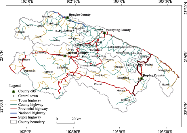
Fig. 2 The transportation map of HHRTS

2.2 Methods

2.2.1 Methods of TA
Roads in the study area are generally winding, and as a result, using the density of the road network as an index indicating the TA of each town in HHRTS is not a particularly scientific approach. Towns in the area have hardly any positive functions in economic development with other towns because the area does not form an integrated regional economic zone. Towns in the area have few economic connections with each other. The shortest path sum and average shortest path are thus not suitable methods for measuring regional TA. Because the level of development in the towns is generally low and the local economies depend largely on agriculture, the economic development of these towns is usually dependent on the nearest high-grade city, a city where the county or prefectural government is located. The key aim of this paper is to analyze the relationship between TA and the local economic level of towns and, thus, to do so this paper constructs a new transportation accessibility index (TAI). This index is based on the shortest time distance from a central town to the high-grade city nearest the town. The smaller the shortest time distance is, the better TA. Time distance (TD) is calculated using this equation:
$TD=\underset{i=1}{\overset{5}{\mathop \sum }}\,{{L}_{i}}/{{S}_{i}} (1)$
TD is the distance between two places, expressed in hours (h); i represents the grade of the roads. There are 5 grades in Hani terraces (Table 1); ${{L}_{i}}$ is the length of the i grade road between two places, expressed in kilometers (km); ${{S}_{i}}$ is the actual mean speed of a car traveling on a i grade road, km/h.
There are numerous roads connecting each town to the nearest high-grade city, and thus, the TD of a town may be denoted by $T{{D}_{mnk}}$:
$T{{D}_{mnk}}=\underset{i=1}{\overset{5}{\mathop \sum }}\,{{L}_{imnk}}/{{S}_{imnk}} (2)$
where m means the number of the town in HHRTS, m = 1, 2, 3, …, 49; n means the number of the high-grade city in HHRTS, n=1, 2, 3, 4; k means the number of the selectable roads from m central town to n city, k=1,2,…,+∞; $T{{D}_{imnk}}$ is the time distance of the k type of selectable roads from m central town to n city; ${{L}_{imnk}}$ is the length of the i grade road of the k type of selectable roads from m central town to n city; ${{S}_{imnk}}$ is the speed of the i grade road of the k type of selectable roads from m central town to n city.
Table 1 The speed of vehicles traveling on different grade roads
Grade Superhighway National highway Provincial highway County highway Town road
Speed(km/h) 110 80 65 30 20
The shortest time distance from m central town to n city can be denoted as $ST{{D}_{mn}}$, and the $ST{{D}_{mn}}$ can be calculated with following equation:
$ST{{D}_{mn}}=\text{min}\left( T{{D}_{mnk}} \right) (3)$
In this study, we use the shortest time distance from one central town to the nearest high-grade city to denote the town’s TAI. So, the transportation accessibility index of m town ($TA{{I}_{m}}$) can be calculated using following equation:
$TA{{I}_{m}}=\text{min}\left( ST{{D}_{mn}} \right) (4)$
A town with a low TAI has better TA, while a town with a high TAI has poor TA.
2.2.2 Data analysis methods
The Network Analyst module was used to calculate the TAI of each town and the Inverse Distance Weighted (IDW) of the Spatial Analyst module in ArcGIS software was used to make the TAI spatial distribution map. The TAI, GOVAPC and IIPC are not usually normal distribution, thus the Spearman correlational analysis is applied to the distribution results. The relationship between the TAI, the GOVAPC and IIPC in 2014 was analyzed and tested using SPSS 18.0 software with the Spearman Correlational Analysis method.

3 Results

3.1 TA of the towns in HHRTS

According to the equation (1), (2), (3) and (4), the TAI of each town was calculated. The TAIs of these towns in HHRTS are very different. The towns near the city with the county government have lower TAIs, meaning that these towns also have higher TAs. As shown in Table 2, the Yisa town, Nansha town, Daxing town and Jinhe town have TAIs below 0.1 of TAI and the four central towns are also the places where county governments (high-grade cities) seat. Sancun town has a TAI of 3.78, which is the highest of all. There are 14 towns with TAIs of less than 1, accounting for 28.5% of all the towns; 12 towns with TAIs between 2 and 3, accounting for 24.5% of all towns; and 3 towns with TAIs above 3, accounting for 6.2% of all towns. The average TAI is 1.47. Table 2 shows that more than 70% of the towns are more than 1 hour away from the nearest city, indicating that the TAs of central towns in HHRTS are not good as a whole.
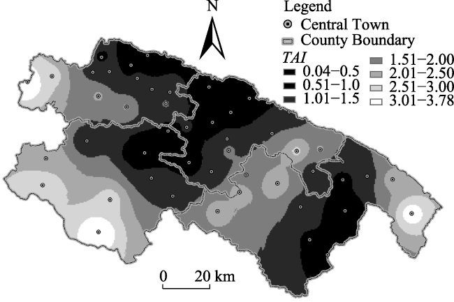
Table 2 TAI of each town in Hani terraces areas
Order Town name County TAI Order Town name County TAI Order Town name County TAI
1 Yisa Honghe 0.04 18 Jiaying Honghe 1.07 35 Fengchunling Yuanyang 2.04
1 Nansha Yuanyang 0.05 19 Baohua Honghe 1.13 36 Luoenxiang Honghe 2.05
1 Daxing Lvchun 0.05 19 Niukong Lvchun 1.13 37 Jiache Honghe 2.09
1 Jinhe Jinping 0.06 21 Shitouzhai Honghe 1.16 38 Dashuigou Lvchun 2.17
5 MaJie Yuanyang 0.59 21 Langdi Honghe 1.16 39 Mentqiao Jinping 2.24
6 Ezha Yuanyang 0.61 23 Daping Yuanyang 1.22 40 Laojizai Jinping 2.26
7 Leyu Honghe 0.63 24 Panzhihua Yuanyang 1.24 41 Zhemi Jinping 2.27
8 Niujiazhai Yuanyang 0.64 25 Sanmeng Lvchun 1.26 42 Yingpan Jinping 2.42
9 Xinjie Yuanyang 0.65 26 Shayipo Jinping 1.32 43 Xiaoxinjie Jinping 2.62
10 Adebo Jinping 0.66 27 Tongchang Jinping 1.36 44 Diema Honghe 2.71
11 Jinshuihe Jinping 0.72 28 Dazhai Jinping 1.37 45 Qimaba Lvchun 2.74
12 Gekui Lvchun 0.88 29 Chegu Honghe 1.47 46 Daheishan Lvchun 2.97
13 Dayangjie Honghe 0.92 30 Pinghe Lvchun 1.49 47 Maandi Jinping 3.28
14 Mengla Jinping 0.93 31 Ganiang Yuanyang 1.50 48 Banpo Lvchun 3.61
15 Shangxincheng Yuanyang 1.00 32 Azhahe Honghe 1.57 49 Sacun Honghe 3.78
16 Huangcaoling Yuanyang 1.01 33 Huangmaoling Yuanyang 1.63
17 Shalatuo Yuanyang 1.03 34 Laomeng Jinping 1.65
A comparison of the four counties (Table 3) shows that Yuanyang County has the lowest TAI, and Lvchun County has the highest TAI with a value 1.6 times greater than that of Yuanyang. Honghe County and Jinping County have similar TAIs. However, the amount of variability among different towns in the same county is based on the variable coefficient of the TAI for each county. There are large differences in the TAs of towns in Honghe County and Lvchun County, while the towns in Jinping County and the towns Yuanyang County have TAs that are roughly the same. Traffic conditions in Jinping County and Yuanyang County are better overall than they are in Honghe County and Lvchun County.
In terms of spatial distribution, the central towns in the northern and middle regions have a lower TAI than those in the west, southwest and east margin regions. Moreover, most of the central towns are located in the northern part of the study area, or put another way, the northern region has a higher density of central towns (Fig. 3).
Table 3 Comparison of traffic accessibility of the four counties in the Hani terraces area
County Mean Maximum Minimum Standard Deviation Variable Coefficient
Honghe 1.52 3.78 0.04 0.96 0.6314
Yuanyang 1.13 2.62 0.05 0.66 0.5844
Lvchun 1.81 3.61 0.05 1.14 0.6300
Jinping 1.57 3.28 0.06 0.89 0.5616
Fig. 3 Spatial distribution of TAI in the Hani terraces areas

3.2 The economic developmental level of the towns in HHRTS

The towns in every county were sequenced based on an ascending sort of TAI (Fig. 4, Fig.5, Fig.6, Fig.7). There is obvious consistency between the level of economic development and the TAI for each town in the same county. In Honghe County, Yisa town had an advantage over other towns in both GOVAPC and IIPC. With respect to the change trend, towns with a higher TAI usually tended to have a higher IIPC, but this characteristic was not found in the relationship between GOVAPC and TAI. There was no obvious correlation between GOVAPC and TAI (Fig. 4).
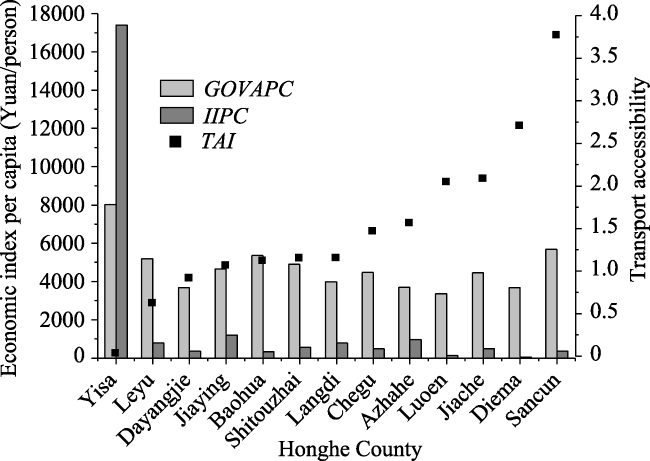
Fig. 4 Economic situations and TAIs of towns in Honghe County in 2014
There was not a big difference between the GOVAPC of the towns in Yuanyang County. Ganiang town, Niujiaozhai town and Huangmaoling town had GOVAPCs a little greater than other towns. With respect to the change trend, towns with a high TAIs did not always have high GOVAPCs (Fig. 5). This indicates that the GOVAPC of a town had low dependence on its TAI in Yuanyang County.
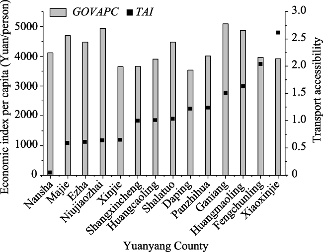
Fig. 5 Economic situations and TAIs of towns in Yuanyang County in 2014
The change trend of TAIs for towns in Lvchun County, was similar to that of GOVAPCs, with the GOVAPCs increasing from towns on the left to towns on the right in Fig. 6. The GOVAPCs of Banpo town, Qimaba town, and Niukong town were first, second and third in Lvchun County. Gekui town had the least GOVAPC in the county.
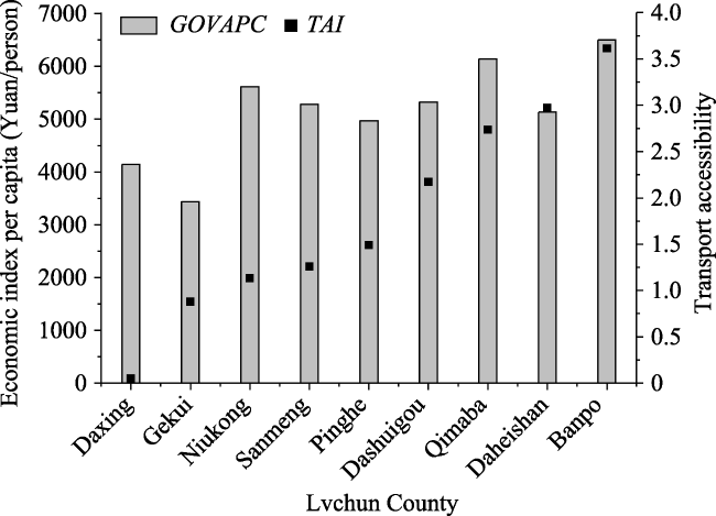
Fig. 6 Economic situations and TAIs of towns in Lvchun County in 2014
In Jinping County, GOVAPCs varied considerably from town to town. Mengqiao Township had the highest GOVAPC, and Mengla Township and Zhemi Township relatively high GOVAPCs. As far as the IIPC was concerned, Jinshuihe Township and Mengla Township enjoyed higher values than other towns. As a whole, the change trend of TAIs was opposite that of IIPC’s (Fig. 7).
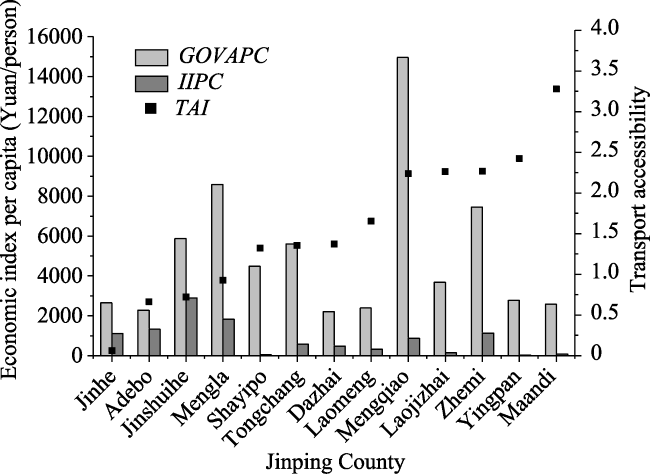
Fig. 7 Economic situations and TAIs of towns in Jinping County
Table 4 Correlativity between TAI and economic indices
TAI GOVAPC IIPC
Honghe -0.38 -0.567*
Yuanyang -0.088
Lvchun 0.667*
Jinping 0.038 -0.615*

Note: * means that the correlation test is significant at level 0.05.

In the four counties, the economy of Honghe County showed the feature of high urban primacy ratio. Economic level of Yisa town the county government is stationed was far higher than other towns. However, Yuanyang County, Lvchun County, and Jinping County had different economic features and the towns the county government is stationed did not show a more advantage than other towns in the economic level (shown by GOVAPC or IIPC). Therefore, geographic location did not seem to play an important role in the economic development of these towns. For example, Mengla Township, Mengqiao Township and Zhemi Township in Jinping County had GOVAPCs that were far higher than other towns due to the planting tropical crops such as banana trees and rubber trees on a large-scale.

3.3 Impacts of TA on economic development in HHRTS

We analyzed the correlation between TAI and economic index of each county, taking into consideration the differences in statistical scopes and indicators between the counties. Results showed a non-significantly negative correlation between GOVAPC and TAI in Honghe County and in Yuanyang County, but an extremely significant positive correlation in Lvchun County and a non-significantly positive correlation in Jinping County. For the counties that had industrial data, Honghe County and Jinping County, TAI and IIPC had a significantly negative correlation. In sum, the correlation between GOVAPC and the TAI was not consistent, but IIPC and TAI had a consistently negative correlation. This indicates that industries have a great dependence on TA, but agriculture does not.

4 Discussion

Hani terraced areas are typical of traditional agricultural areas, and agriculture is the pillar of the economies of the towns. Owing to the limited amount of land that can be cultivated, the agricultural products produced by local farmers just meet the demands of local people. In fact, some of the meat, eggs, milk, and vegetables used in the towns needs to be bought from other areas (Cao et al., 2015). Therefore, although the towns in this area have semblable natural conditions and economic features, they cannot form an economic zone in which the towns can promote each other. Moreover, residents of central towns usually must go to the nearest high-grade city to buy better quality consumer goods or sell surplus agricultural products. The minimum time distance from a central town to the nearest high-grade city is an appropriate index to reflect objectively the real TA of each town. Thus, this paper constructed a method using the shortest time distance to calculate and assess TAs of the towns in HHRTS. The relationship between TAI and IIPC is consistent with that found in other studies (Henry and Johnson, 1993; Ades and Glaeser, 1999). However, the functions of the high-grade cities outside HHRTS but near to these central towns in HHRTS may be excluded, because they were not considered when assessing the TAIs of the central towns. Considering actual traffic links in HHRTS (Fig. 2), the exclusion of high-grade cities outside of HHRTS did not have an important impact on the assessment results for TAI, but these cities must be considered in evaluating the TA of other regions in future.
In terms of spatial distribution, central towns in the northern and the middle regions of HHRTS have higher TAIs and denser transportation networks than central towns in other parts of the region. These distribution characteristics are the result of two factors. The first is topography and climate. As shown in Fig. 8, most towns are situated on the sides of mountains at elevations of 1200 to 2000 m. This is because the climate in low elevation valleys is very hot and wet owing to that fact that HHRTS is located south of the Tropic of Cancer. These valleys are not well-suited for human inhabitation. The central towns have gradients of less than 25°(Fig. 9). The topography in the northern and the middle regions is relatively level and this benefits production and life. The second factor is that no arterial traffic passes through this area because HHRTS is located in a border area. The low-grade traffic links mainly serve local people. The places with denser concentrations of villages and cities also have denser traffic links; that is, they have higher TAIs. Therefore, the TA in this area is influenced by the natural features and location conditions.
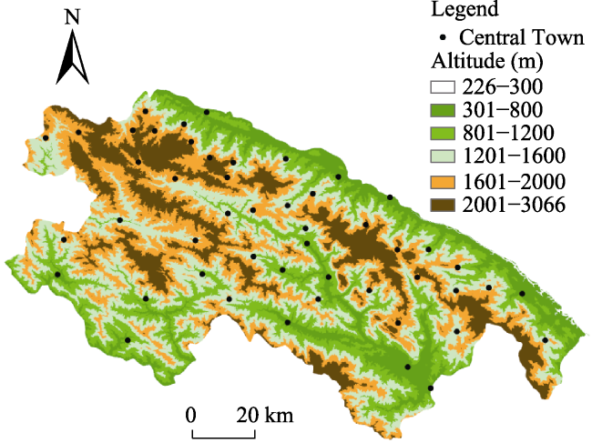
Fig. 8 Altitude distribution of HHRTS
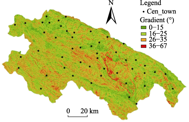
Fig. 9 Gradient distribution of HHRTS
TAI has an obvious impact on the level of industrial development of towns in HHRTS, but not on the level of their agricultural development. This is because the agricultural products produced in HHRTS are mainly for local consumption, with only a fraction of agricultural products being traded in the markets of the central towns. Additionally, technological progress has increased the length of time agricultural products can be kept after harvest (for example, bananas can now be kept for more than 15 days after harvest according to surveys) and decreases the dependence of agricultural products’ transportation on the TA of a place. Hence, agricultural products have a low sensitivity to changes of TA. For secondary industries, owing to the importance of transportation costs on production and product marketing, TA is a crucial factor in selecting the location of a factory. This explains why IIPC has a negative correlation with TAI for towns in a county.
The systems that town-level governments in China use to gather statistics are not optimal and this limits the availability of statistical data, and this limitation has resulted in inadequacies of the analyses in this study. Firstly, we collected data on secondary industries only from Honghe County and Jinping County; we collected no data on tertiary industries from any of the four countries. Thus, we were only able to fully analyze the relationship between TA and agriculture and to provide a partial analysis of the relationship between TA and secondary industries. Secondly, the planting structure of crops can impact the relationship between agriculture and TAI. For example, the GOVAPC of Mengla Township in Jinping County is far higher than GOVAPCs in other towns because of the planting of rubber and banana trees in the township (Fig. 7). Thirdly, the development of tourism industry is playing an important role in the development of local economies in the area (Gao and Wu, 2017). Exploring the relationship between TA and tertiary industries has a crucial significance for understanding development in mountainous areas. Lack of data on tertiary industries means we cannot assess the impact of TA on tertiary industries such as tourism. Finally, owing to the inconsistency of data collection methods used in different towns, this study only analyzes correlations of the relationships between TAI and GOVAPC and IIPC in the four counties. The results show the relative relationships between the counties, but do not show cause-effect relationships.
Studies of town-level TA are very rare because of lack of data, and thus assessment methods for the TA of central towns have not been adequately explored. Actually, transportation assessments of central towns in rural areas are very different from assessments of county-level cities and other urban areas due to differences in natural conditions, economic structure, socio-culture conditions, and regional functions (Shrestha et al, 2014; Athanasenas, 1997). Half of China’s population lives in rural areas and the Chinese government has formulated policies to integrate industries in rural areas, making these important human settlements an increasing focus of research. The impact of TA is a crucial factor that must be considered in industrial distribution. Scientific TA assessment methods will be considered from different perspectives and continue to be improved in the future.
Besides, other than the relationship between TA and economic development, we must consider other impacts of TA, especially for those special areas. For example, in ecologically fragile regions and IAHS sites, whether to construct high-grade roads needs to be considered discreetly because the TA improvement may induce indirectly natural disasters, eco-environmental degradation, or heritage system destruction (Trombulak and Frissell, 2000; Kasaei and Salman, 2016). Because HHRTS is a GIAHS, a China national wetland park and a World Cultural Heritage location, building high-grade roads based on economic consideration only is inappropriate against a background of low population density and unstable geological conditions. A holistic approach and extensive study is needed to formulate a suitable road construction scheme for the area.

5 Conclusions and suggestions

The TA of central towns in HHRTS area is not good as a whole. More than 70% of the towns are more than 1 hour away from the nearest high-grade city. In the four counties, Yuanyang County has the best traffic condition and Lvchun County has the worst traffic conditions and the differences in traffic conditions between the towns in the county are the greatest of the four counties. Honghe County has a better traffic conditions, but difference in conditions between towns is very large. The central towns in the northern and middle regions have better TA than in the west, southwest and east margin regions. The small-scale agricultural operations that characterize the area have a low dependence on TA, while secondary industries have a high dependence on TA. Thus traffic conditions must be considered as an important determinant when considering a developmental direction for industries in a locale.
According to the results of this study, a definite development direction should be determined by each town in HHRTS based on its resource advantages and traffic conditions. As a way to keep transportation costs low and ensure that products are carried to markets as quickly as possible, the development of processing and manufacturing industries in towns with better TAs should be prioritized. At the same time, prefecture governments should develop and implement holistic transportation network plans that take into consideration the developmental orientation and current traffic conditions of each town in HHRTS. Road construction for towns with rich resources to support the development of secondary and tertiary industries should be promoted. However, the building of high-grade roads should be banned in areas that are or will be designated ecological protection zones or that have highly fragile ecologies.

The authors have declared that no competing interests exist.

[1]
Ades A, Glaeser E.1999. Evidence on growth, increasing returns and the extent of the market.Quarterly Journal of Economics, 114(3): 1025-1046.

[2]
Athanasenas A.1997. Traffic simulation models for rural road network management.Transportation Research Part E, 33(3): 233-243.

[3]
Cao Z, Min Q W, Liu M C, et al.2015. Ecosystem-Service-based ecological carrying capacity: concept, content, assessment model and application.Journal of Natural Resources, 30(1): 1-11. (in Chinese)

[4]
Crossley C P.1981. Rural road characteristics and vehicle operating costs in developing countries.Journal of Terramechanics, 18(4): 209-228.

[5]
Gao J, Wu B H.2017. Revitalizing traditional villages through rural tourism: A case study of Yuanjia Village, Shaanxi Province, China.Tourism Management, 63: 223-233.

[6]
Ge L, Gao M, Hu Z, et al.2012. Reasons of cultivated land abandonment in mountainous area based on farmers' persperctive.Chinese Journal of Agricultural Resources & Regional Planning, 33(4): 42-46.

[7]
Gulyás A, Kovács Á.2016. Assessment of transport connections based on accessibility.Transportation Research Procedia, 14: 1723-1732.

[8]
Gutiérrez J L.2001. economic potential and daily accessibility: an analysis of the accessibility impact of the high-speed line Madrid-Barcelona- French border.Journal of Transport Geography, 9(4): 229-242.

[9]
Hansen W G.1959. How accessibility shapes land use.Journal of the American Institute of Planners, 25(2): 73-76.

[10]
Henry M, Johnson T G.1993. The contribution of transportation to rural economic development.Sdrc, 1993: 35-46.

[11]
Holl A.2007. Twenty years of accessibility improvements. the case of the Spanish motorway building programme.Journal of Transport Geography, 15(4): 286-297.

[12]
Kasaei M, Salman F S.2016. Arc routing problems to restore connectivity of a road network.Transportation Research Part E, 95: 177-206.

[13]
Kotavaara O, Antikainen H, Rusanen J.2011. Population change and accessibility by road and rail networks: GIS and statistical approach to Finland 1970-2007.Journal of Transport Geography, 19(4): 926-935.

[14]
Li S M, Shum Y M.2001. Impacts of the national trunk highway system on accessibility in China.Journal of Transport Geography, 9(1): 39-48.

[15]
Liu H L, Bao A M, Chen X., et al.2008. The effect of transportation accessibility on regional economic performance.Acta Geographica Sinica, 63(4): 428-436. (in Chinese)

[16]
Liu M, Xiong Y, Yuan Z, et al.2014. Standards of ecological compensation for traditional eco-agriculture: Taking rice-fish system in Hani terrace as an example.Journal of Mountain Science, 11(4): 1049-1059.

[17]
Meng Q, Yang H.2002. Benefit distribution and equity in road network design.Transportation Research Part B, 37(4): 345-363.

[18]
Min Q W, Zhang Y X, Jiao W J, et al.2016. Responding to common questions on the conservation of agricultural heritage systems in China.Journal of Geographical Sciences, 26(7): 969-982.

[19]
Munnell A.1990. How does public infrastructure affect regional economic performance? New England Economic Review, (8/9): 11-33.

[20]
Odoki J B, Kerali H R, Santorini F.2001. An integrated model for quantifying accessibility-benefits in developing countries.Transportation Research Part A, 35(7): 601-623.

[21]
Qiu Z. M., Chen B. X., Takemoto K.2014. Conservation of terraced paddy fields engaged with multiple stakeholders: the case of the Noto GIAHS site in Japan.Paddy Water Environment, 12: 275-283.

[22]
Shrestha J K, Benta A, Lopes R B.et al.2014. A multi-objective analysis of a rural road network problem in the hilly regions of Nepal.Transportation Research Part A, 64: 43-53.

[23]
Sun Y H, Min Q W, Cheng S K, et al.2009. The temporal and spatial suitability assessment in the tourism resources development of agricultural heritage system.Resources Science, 31(6): 942-949. (in Chinese)

[24]
Sun Y, Jansen-Verbeke M, Min Q, et al.2011. Tourism Potential of Agricultural Heritage Systems.Tourism Geographies An International Journal of Tourism Space Place & Environment, 13(1): 112-128.

[25]
Tian M, Min Q W, Jiao W J, et al.Agricultural Heritage Systems Tourism: definition, characteristics and development framework.Journal of Mountain Science, 13(3): 440-454.

[26]
Tian M, Min Q W,Lun F, et al.2015. Evaluation of tourism water capacity in agricultural heritage sites.Sustainability, 7(11): 15548-15569.

[27]
Trombulak S C, Frissell C A, 2000. Review of ecological effects of roads on terrestrial and aquatic communities Conservation.Biology, 14: 18-30.

[28]
Wang B, Min Q W, Jiao W J.2016b. Status, Potentials and Development Strategies of Agricultural Heritage Systems in Zhejiang Province.Journal of Resources and Ecology, 7(3): 155-162.

[29]
Wang Lvhua, Liu Yongxue, Sun Chao, et al.2016a. Accessibility impact of the present and future high-speed rail network: A case study of Jiangsu Province, China.Journal of Transport Geography, 54: 161-172.

[30]
Wu P, Wu J F, Zhou F R, et al.2016. Research on the method of the evaluation about the traffic accessibility of the destination inner part—Xi’an as the Example.Journal of Zhejiang University (Science Edition), 43(3): 345-356. (in Chinese)

[31]
Yiu E.2014. Noto Peninsula after GIAHS Designation: Conservation and Revitalization Efforts of Noto’s Satoyama and Satoumi,Journal of Resources and Ecology, 5(4):364-369.

[32]
Zhang Y X, Liu M C, Min Q W, et al.2015. Calculation of price compensation of agriculture products in the period of organic conversion in agricultural heritage sites—taking paddy rice of Hani terrace in Honghe County of Yunnan Province as an example.Journal of Natural Resources, 30(3): 374-383. (in Chinese)

[33]
Zhang Y X, Min Q W, Jiao W J, et al.2016. Values and conservation of Honghe Hani Rice Terraces System as a GIAHS site.Journal of Resources and Ecology, 7(3): 197-204.

[34]
Zhang Y, Li X, Song W.2014. Determinants of cropland abandonment at the parcel, household and village levels in mountain areas of China: A multi-level analysis.Land Use Policy, 41: 186-192.

Outlines

/