Facing the impacts of climate change and the ecological environmental problems caused by urbanization, urban-rural resilience is a new value goal of territorial space development. Blue-green space is an interconnected network system of natural and artificial green space and water bodies, which can dissolve the internal and external pressures of the system by way of mitigatory acceptance and adaptive interaction, reduce the impact of climate change and artificial construction disturbances, and provide diversified composite functions. By recognizing the connotation of the concept of blue-green space, its composite ecological functionality and its relationship with the value of urban-rural resilience, this paper constructs a conceptual framework for the integrated planning of blue-green space in urban and rural areas with “resilient objectives, resource identification, integrated configuration, differentiated regulation”. The paper proposes an integrated and coordinated multi-scale practicable approach of blue-green space planning (i.e., the construction of the blue-green corridor network, the configuration of blue-green open space, the allocation of blue-green infrastructure) and the regulation-based urban-rural transect, with the aim of improving the hydroecological performance and composite functional services in order to realize urban and rural resilience.
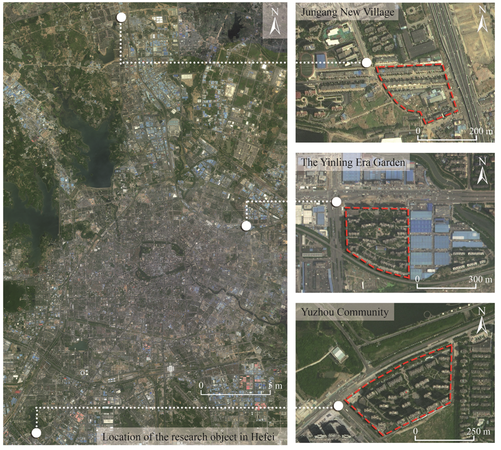
In the context of disaster normalization, the concept of “resilience” has been gradually introduced into the field of disaster prevention and mitigation in urban communities. In order to resist the increasingly frequent disasters caused by extreme weather, it is necessary to shift the focus of building resilient urban communities to the level of stormwater management. Community resilience is a disaster prevention and mitigation capability based on community resources. In order to solve the deficiency of storm and flood management in the current construction of resilient communities in China, it is necessary to establish a quantitative evaluation system to evaluate it. This paper uses the analytic hierarchy process and Delphi method to establish a community resilience evaluation system from the perspectives of community material space level, community management level and individual level. Then three communities in Hefei City, Anhui Province are selected for practical application of the system, and corresponding optimization and transformation strategies are proposed. The results show that: (1) The resilience of community stormwater management is closely related to the integrated environment of the community, the allocation of flood control facilities and the daily disaster prevention and mitigation management; (2) The ability of disaster prevention and mitigation and the awareness of public participation of the residents in all communities are relatively weak, and the communities invest less in the popularization of stormwater management wisdom; and (3) Resilient communities should not only pay attention to the construction of non-engineering disaster prevention measures, but also to the application of small-scale green infrastructure oriented toward stormwater management.
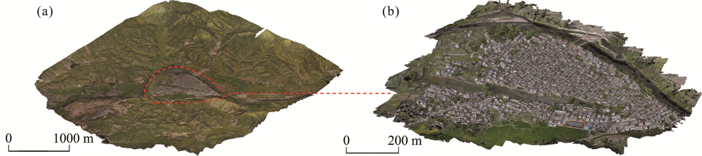
During the long-term construction and development process of eliminating water disasters and promoting water conservancy in traditional settlements, a set of mature strategies that have simple ecological wisdom in water layout have been formed by adapting to the natural water environment and utilizing the regional water system. This study conducted a qualitative and quantitative analysis of the water layout strategies and their effects on Liukeng Village from three aspects: deciphering the water systematic pattern, calculating the spatial characteristics and quantifying the water environment, to explore the technical assistance and potential of water layout research in traditional rural settlements. The results indicated that Liukeng has an unambiguously systematic water layout pattern of source diversion, middle drainage and end purification of the water. Through 3D point cloud computing, it was shown that the site selection made accurate use of micro-topography and adopted the strategy of a multi-source water management. It formed an organic water system pattern, which provided sufficient water sources for all kinds of needs of Liukeng Village.The Dragon Lake in Liukeng held 83.0% of the precipitation, and the vegetation area accounted for 34.7% of the total area of Liukeng, which had high surface permeability and good middle drainage effects. Water detection showed that the Dragon Lake provided good water quality and purification. The purposes of this study are to fill the gap in previous non-quantitative research on water layout in traditional rural settlements, excavate the hidden information and value of settlements, and deepen our understanding of the ecological wisdom of the overall planning, layout and construction of water conservancy in traditional rural settlements. This knowledge can assist the win-win situation of water conservancy cultural heritage protection and modern utilization. It also provides useful inspiration and reference for properly dealing with the problems of rain and flooding, realizing the sustainability of water resources, and protecting the ecological environment in the process of the development and construction of village settlements in China.
China's urban expansion, food security, and energy transition are in a critical situation. One solution is to tap into the green production potential of the built urban environment and explore new ways to save land space and alleviate ecological pressure through food and solar energy production. This paper differs from previous ecological compensation studies, which mostly focus on key ecological functional areas or fiscal compensation mechanisms, in that it innovatively establishes an ecological compensation mechanism within the urban space. In this paper, we propose the "green productive area" of cities as a way to measure the ecological carrying capacity improvement potential of cities from the perspective of urban ecology, and it is based on converting the green resource income of cities into the ecological footprint area they could save under the same conditions. First, a typological approach was used to establish a compensation strategy for green production. Second, a spatial inventory was taken of all elements of the built environment and an analysis of their green production potential was carried out. Finally, it was necessary to establish a unified accounting standard for the ecological land saving benefits of different green production options, which could be converted into green productive land area indicators. In the case of Xuefu Street in Nankai District, Tianjin, the available rooftops and idle land were used for green production, which supplemented the ecological carrying capacity provided by the natural land occupied by 12% of the buildings in the district.
Cropland abandonment is spreading from developed countries to developing countries such as China. Cropland abandonment in China commonly occurs in mountainous areas due to their specific natural and geographical conditions. However, due to the lack of dependable monitoring methods via medium-high-resolution remote sensing images, the scale of abandoned cropland in many mountainous areas of China is unclear, and the mechanisms driving cropland abandonment have not been clearly identified. To overcome these limitations, we took Zhong County of Chongqing in China as an example, and used Landsat 8 OLI_TIRS remote sensing image data to develop a method for mapping abandoned cropland in mountainous areas based on annual land use change monitoring. At the same time, the ridge regression method was adopted to analyze the factors influencing cropland abandonment. These analyses showed that the cropland abandonment rate in Zhong County of Chongqing was as high as 7.86%, while the overall accuracy of identifying abandoned cropland was as high as 90.82%. Among the social and economic factors that affect cropland abandonment, the rural population, economic development, and livestock husbandry development were the most important ones. At the land parcel scale, large-scale cropland abandonment occurred in areas at elevations above 650 m or with slopes of more than 15°.
Cultivated land pressure is often used to reflect the shortage of cultivated land resources. By using the methods of the Cultivated Land Pressure Index, coefficient of variation and cold-hot spot analysis, this paper analyzes the spatial-temporal differentiation pattern and dynamic change processes of cultivated land pressure in the counties of the Pearl River-Xijiang Economic Zone from 2008 to 2017, and measures the factors which influence cultivated land pressure by using Principal Component Analysis. The results show that the cultivated land pressure in the Pearl River-Xijiang Economic Zone has been in a “high pressure” state, and the Cultivated Land Pressure Index has been rising continuously from 2008 to 2017. The coefficient of variation of the Cultivated Land Pressure Index in the Pearl River-Xijiang Economic Zone and various prefecture-level cities is fluctuating and rising, which indicates that the overall spatial differences in the cultivated land pressure in this region are expanding and polarization is obvious. In addition, the area where the municipal district of the provincial capital city is located is the core area of urban development and also the area with the greatest cultivated land pressure. The spatial pattern of cultivated land pressure cold-hot spots in the Pearl River-Xijiang Economic Zone is obviously heterogeneous, in which the Pearl River Economic Zone is the main hot spot gathering area and the Xijiang Economic Zone is the main cold spot gathering area. Farmers' income, investment in fixed assets, GDP, population and other socio-economic factors are the main factors driving the changes in the cultivated land pressure in the Pearl River-Xijiang Economic Zone. Furthermore, farming production factors, such as the multiple cropping index and grain yield per unit area, will also have an important impact on the changes in the cultivated land pressure.
Total nitrogen (TN), total phosphorus (TP), total potassium (TK), and soil organic matter (OM) can significantly affect forest growth. However, these soil properties are spatially heterogeneously distributed, complicating the prescription of forest management strategies. Thus, it is imperative to obtain an in-depth understanding of the spatial distribution of soil properties. In this study, soils were sampled at 181 locations in the Tropical Forest Research Center in the southwestern Guangxi Zhuang Autonomous Region in southern China. We investigated the spatial variability of soil OM, TN, TP, and TK using geostatistical analysis. The nugget to sill ratio indicated a strong spatial dependence of soil TN and a moderate spatial dependence of soil OM, TP, and TK, suggesting that TN was primarily controlled by intrinsic factors (e.g., soil texture, parent material, vegetation type, and topography), whereas soil OM, TP, and TK were controlled by intrinsic and extrinsic factors (e.g., cultivation practices, fertilization, and planting systems). Based on the spatial variability determined by the geostatistical analysis, we performed ordinary kriging to create thematic maps of soil TN, TP, TK, and OM. Model validation indicated that the thematic maps were reliable to inform forest management.
In this paper, the life cycle assessment (LCA) method is used to evaluate and quantify the energy consumption and environmental impacts of biodegradable polylactic acid (PLA) plastic packaging from the five stages of raw material acquisition, raw material transportation, product production, products use and final disposal. Seven impact categories were selected for the impact analysis: abiotic depletion potential fossil fuels (ADP), global warming potential (GWP), acidification potential (AP), eutrophication potential (EP), photochemical ozone formation potential (POCP), human toxicity potential (HTP), and terrestrial ecotoxicity potential (TETP). The results of the LCA are discussed and the results show that production of products is the highest stage of the environmental impact. Meanwhile, in the entire life cycle, the top three environmental impact categories are GWP, ADP and HTP, which account for 32.63%, 24.83% and 14.01%, respectively. The LCA results show that the environmental impact can be reduced in several ways: reducing the consumption of electricity, increasing the input of new energy, increasing the conversion rate of materials in the production process, using organic and water-soluble fertilizers instead of conventional fertilizers, using environment-friendly fuels and establishing a sound recycling system.
Sustainable Livelihood Security (SLS) remains a rarely considered yet important issue for rural sustainability and natural resource management. Particularly in China, rural SLS research in a typical area is urgently needed, but insufficient under the background of National Rural Revitalization and Ten-year Fishing Ban of Yangtze River. Focusing on the policy-targeted inland lake area, we proposed a Livelihood Security Analysis (LSA) framework by establishing an adaptive indicator system and integrating multiple econometrical and geographical methods. This study aims to evaluate the SLS in Poyang Lake Eco-economic Zone comprehensively from the three aspects of ecology, economy and society, analyze their spatial patterns, identify the main constraints, and finally give specific suggestions for improving rural sustainability management. The results showed that rural SLS in the inland great lake area tended to be vulnerable mainly due to the lagging economic efficiency and unbalanced social equality, and mediated by regional ecological characteristics. The overall SLS and Ecological Security Index (ESI) were higher in the north and lower in the south, while Economic Efficiency Index (EEI) and Social Equality Index (SEI) were at the middle level and circularly distributed around Nanchang City. The dominating factors which have greatly shaped the spatial pattern of SLS include rural per capita electricity consumption, fishery breeding area, population dependency ratio, urbanization rate, and fishery population. The obstacle degree is ranked as economic system > social system > ecological system. An outdated economy and incomplete social services are the main constraints, characterized by weak electricity consumption, limited beds in hospitals, low urbanization rate, deficient agricultural machinery power, and a small agricultural output value. Therefore, one urgent need is to activate the rural economy by reinforcing rural electric power facilities and promoting agricultural mechanization. In addition, transforming the peasants/fishermen to the non-agricultural sector should be accelerated, which will help to reduce ecological pressure, boost urban-rural integration and narrow the income gap.
By studying the structural characteristics and carbon storage of the mangrove island ecosystem in the Beibu Gulf, this study provides a scientific basis for mangrove ecological compensation in the coastal areas of Guangxi, South China Sea. On the basis of the unmanned aerial vehicle remote sensing images and a sample plot survey, the object-oriented multi-scale segmentation algorithm is used to extract the mangrove community type information, and one-way analysis of variance is conducted to analyse the structural characteristics of the mangrove community. The carbon storage and carbon density of different mangrove ecosystems were obtained based on the allometric growth equation of mangrove plants. The analysis yielded four main results. (1) The island group covers about 27.10 ha, 41.32% (11.20 ha) of which represents mangrove areas. The mangrove forest is widely distributed in the tidal flats around the islands. (2) The main mangrove types were Aegiceras corniculatum, Kandelia obovata + Aegiceras corniculatum, Avicennia marina + Aegiceras corniculatum and Avicennia marina communities. (3) Amongst the mangrove plants, Avicennia marina had the highest biomass (18.52 kg plant-1), followed by Kandelia obovata (7.84 kg plant-1) and Aegiceras corniculatum (3.85 kg plant-1). (4) The mangrove carbon density difference was significant. Kandelia obovata had the highest carbon density (148.03 t ha-1), followed by Avicennia marina (104.79 t ha-1) and Aegiceras corniculatum (99.24 t ha-1). The carbon storage of the mangrove island ecosystem was 1194.70 t, which was higher than in other areas with the same latitude. The carbon sequestration capacity of the mangrove was relatively strong.
With increasing numbers and types of nature reserves (NRs), objective evaluation and comparison of the effects of different nature NRs on conservation efforts are of great importance for protecting species diversity, ensuring reasonable national economic input, and adjusting government management schemes. Developing a method for the combined assessment of flagship or umbrella species and ecosystem quality will improve the evaluation of NRs. However, it is also important to establish a new framework for rapid evaluation of ecosystem quality, supported by the advantages of scientific, economic, and regular principles. Here, we proposed a new framework that incorporates the novel concept of ideal references into evaluation systems, which will facilitate the comparison of results from different periods and regions. Furthermore, from the perspective of making the framework as objective, rapid, and economical as possible, we recommended some key ecological indicators, such as net primary productivity, soil organic matter, plant diversity, for use in the new evaluation framework. The new framework, referred to as “ideal reference and key indicators” (IRKI), can sufficiently meet the requirements for the rapid evaluation of ecosystem quality both regionally and nationally. Furthermore, IRKI can identify the restoration potential and restoration periods of NRs, thus facilitating the rational distribution of resources and enhancing the protective effect. There are many types of NRs in China, and it is necessary to partially alter the assessment methods or parameters for different types of NRs. Overall, IRKI provides a simple, clear, and comparable framework that will strongly enhance the conservation of protected areas (PAs) and facilitate the standardization of management practices.
The alpine treeline ecotone is defined as a forest-grassland or forest-tundra transition boundary either between subalpine forest and treeless grassland, or between subalpine forest and treeless tundra. The alpine treeline ecotone serves irreplaceable ecological functions and provides various ecosystem services. There are three lines associated with the alpine treeline ecotone, the tree species line (i.e., the highest elevational limit of individual tree establishment and growth), the treeline (i.e., the transition line between tree islands and isolated individual trees) and the timber line (i.e., the upper boundary of the closed subalpine forest). The alpine treeline ecotone is the belt region between the tree species line and the timber line of the closed forest. The treeline is very sensitive to climate change and is often used as an indicator for the response of vegetation to global warming. However, there is currently no comprehensive review in the field of alpine treeline advance under global warming. Therefore, this review summarizes the literature and discusses the theoretical bases and challenges in the study of alpine treeline dynamics from the following four aspects: (1) Ecological functions and issues of treeline dynamics; (2) Methodology for monitoring treeline dynamics; (3) Treeline shifts in different climate zones; (4) Driving factors for treeline upward shifting.
The snow leopard (Panthera uncia) inhabits a human-altered alpine landscape and is often tolerated by residents in regions where the dominant religion is Tibetan Buddhism, including in Qomolangma NNR on the northern side of the Chinese Himalayas. Despite these positive attitudes, many decades of rapid economic development and population growth can cause increasing disturbance to the snow leopards, altering their habitat use patterns and ultimately impacting their conservation. We adopted a dynamic landscape ecology perspective and used multi- scale technique and occupancy model to better understand snow leopard habitat use and coexistence with humans in an 825 km2 communal landscape. We ranked eight hypothetical models containing potential natural and anthropogenic drivers of habitat use and compared them between summer and winter seasons within a year. HABITAT was the optimal model in winter, whereas ANTHROPOGENIC INFLUENCE was the top ranking in summer (AICcw≤2). Overall, model performance was better in the winter than in the summer, suggesting that perhaps some latent summer covariates were not measured. Among the individual variables, terrain ruggedness strongly affected snow leopard habitat use in the winter, but not in the summer. Univariate modeling suggested snow leopards prefer to use rugged land in winter with a broad scale (4000 m focal radius) but with a lesser scale in summer (30 m); Snow leopards preferred habitat with a slope of 22° at a scale of 1000 m throughout both seasons, which is possibly correlated with prey occurrence. Furthermore, all covariates mentioned above showed inextricable ties with human activities (presence of settlements and grazing intensity). Our findings show that multiple sources of anthropogenic activity have complex connections with snow leopard habitat use, even under low human density when anthropogenic activities are sparsely distributed across a vast landscape. This study is also valuable for habitat use research in the future, especially regarding covariate selection for finite sample sizes in inaccessible terrain.
Gross ecosystem product (GEP) is the gross value of all ecosystem products and services provided by ecosystems for human society. In practice, GEP measures the ecosystems' contributions to human well-being and constitutes one of the core issues in the construction of ecological civilization systems. Currently, GEP accounting faces a series of problems, such as the inconsistency of accounting subjects and a lack of accounting standards, the result of which is the non-reproducibility and weak applicability of accounting results. In this paper, mainstream models for ecosystem service valuation are summarized in a systematic manner. On this basis, eight basic principles are established for screening accounting indicators: biological productivity, human benefits, production territoriality, current increment, actual effectiveness, physical metrizability, data availability, and harmlessness. Next, a series of ecosystem service subjects are identified that need to be excluded from accounting, and the detailed reasons for their exclusion are presented. Finally, three ideas for improving GEP accounting are offered from the perspectives of the relationship between biological production and human production, the circulation-transport relationship and spatial differences, and harms to the ecosystem carrying capacity. The purpose is to provide positive considerations aimed at promoting the socio-economic applications of accounting and to contribute to the scientific quantification of the values of ecological products.
Eco-agriculture is the principal measure for addressing the environmental issues caused by agriculture and an essential direction for agriculture in the future. Meanwhile, the development of eco-agriculture is inseparable from its technical support. At present, the eco-agricultural technologies commonly used in China can be divided into three categories according to their theoretical basis and practical types: the technologies used to realize the precision input of material resources, the technologies used to improve material circulation efficiency, and the technologies that use the principle of species symbiosis. Although these technologies provide essential support for developing eco-agriculture in China, there are also problems associated with their implementation, such as poor technical application and a low level of industrialization. Therefore, in the future development of eco-agriculture technology in China, the technologies producers should take the actual problems as guide and pay attention to the popularization, industrialization, and application of the technologies.
Urban biodiversity is now recognized as playing a critical role in supporting global biodiversity. However, it is important to note that biodiversity is a systematic and holistic concept and prior studies have not generally focused on cross-border or multi-scale management problems. On one hand, the ecosystems of cities are interconnected with adjacent cities by natural landscapes, so they are like mosaics instead of being isolated. Urban biodiversity research demands the consideration of the continuity within an ecosystem. On the other hand, both active protection and passive restoration strategies for urban biodiversity should not only be developed by researchers or municipal government agencies, but more importantly, they should consider the real ecosystem management problems faced by multi-scale departments in order to build a practicable Pressure-State-Response (PSR) model. The solutions for these issues should be included in the analysis to form a complete and more effective urban biodiversity strategy. The study in this paper offers an answer to whether different scales of cities or districts should adopt the same biodiversity strategy; and therefore, the decision depends on whether the places are of the same importance to the global or regional ecosystem, or whether the ecological elements are connected to the adjacent cities/districts and the problems that multiple stakeholders care about.
In the early 1980s, to control soil and water loss in the rainy season and problems of water shortages in the dry season in the red soil hilly region of central Jiangxi, the academician team of Li Wenhua from Qianyanzhou Station of the Chinese Academy of Sciences proposed a comprehensive muti-dimensional agriculture development mode known as the “Qianyanzhou Mode”. Since then, models for the forest-livestock-food ecosystem, forest-fruit-economy ecosystem, and land-water compound muti-dimensional system and others have been tested, demonstrated, promoted and used to solve major issues in ecological restoration and agricultural production. With the dawn of the new era, the Qianyanzhou Mode is being given new connotations. In order to reduce the use of pesticides and eliminate the use of antibiotics for improving the quality of agricultural products, increasing farmers' income, and assisting in strategies for rural vitalization, Qianyanzhou Station is currently focusing on the development of experiments and demonstrations of green agricultural development modes, such as forest-fruit-fowl, hybrid paper mulberry-pig-fruit, grass-sheep(cattle)-fertilizer-fruit, hybrid paper mulberry-fish-goose, paddy-shrimp, and others. The goal of this new effort is to apply the wisdom of Qianyanzhou to the construction of the ecological civilization, including ecological environment protection and the prosperity of farmers in the old revolutionary base areas in central Jiangxi Province.
Basic oxygen furnace (BOF) slag, the solid waste produced in the steelmaking process, is reused in industry, agriculture and environmental treatment. However, as an adsorbent for wastewater, the removal effect of BOF slag on anionic pollutants needs to be improved. In this study, acid and alkali were used to modify BOF slag, and the removal efficiency and mechanism of arsenic(V) with modified BOF slag in solution were studied. The effects of the As(V) initial concentration, solution pH and reaction time on the removal efficiency were determined by batch experiments, and the removal mechanism of As(V) using modified BOF slag was studied by an adsorption kinetic model and isothermal adsorption model and the Fourier transform infrared spectroscopy (FTIR) and X-ray photoelectron spectroscopy (XPS) spectral analysis. The results showed that the slag modified by 15% sulfuric acid had the best removal effect on As(V), while the removal effect of As(V) by alkali-modified slag was not ideal. The removal rate of As(V) by acid-modified slag increased with the increase in the initial concentration, decreased slowly with the increase in pH and reached equilibrium in 180 min. The adsorption kinetic model and isothermal adsorption model of As(V) by acid-modified BOF slag showed that the chemical adsorption was the limiting step. The FTIR and XPS analysis results showed that the silicate and ferrite in the acid-modified slag could remove As(V) in the solution by ion exchange to form an arsenate precipitate. Therefore, modified BOF slag can be used as a potential adsorbent for large scale arsenic polluted waterbody to realize the ecological utilization of industrial solid waste.